yogyakarta city transport service planning for integration
TRANSCRIPT
1
ISSN 2089-6131 (print)ISSN 2443-1311 (Online)DOI 10.22146/teknosains.34699https://jurnal.ugm.ac.id/teknosains
YOGYAKARTA CITY TRANSPORT SERVICE PLANNING FOR INTEGRATION WITH EXISTING TRANSPORT
Siti Malkhamah1*, Almira Pavita Eska1, and Alvian Mustafa1
1Department of Civil and Environmental Engineering,Faculty of Engineering, Universitas Gadjah Mada
Submitted: 12-04-2018; Revised: 24-08-2018; Accepted: 26-08-2018
ABSTRAKBus pariwisata dianggap sebagai salah satu penyebab kemacetan di Kota Yogyakarta ketika libur panjang. Penelitian ini dilakukan bertujuan untuk merencanakan angkutan wisata yaitu Trans Jogja Wisata yang terintegrasi dengan angkutan yang ada untuk mengakomodasi wisatawan menuju ke lokasi wisata dari lokasi park and ride. Pengumpulan data dilakukan dengan melakukan survei wawancara pada wisatawan di Tempat Khusus Parkir di Kota Yogyakarta. Data yang dikumpulkan meliputi data tujuan wisata wisatawan, jalan masuk bus pariwisata ke Kota Yogyakarta, dan kondisi lingkungan. Berdasarkan hasil perencanaan Trans Jogja Wisata yang terintegrasi dengan Angkutan yang ada, terdapat 4 trayek yang digunakan untuk mengakomodasi wisatawan untuk berwisata ke Kota Yogyakarta, yaitu Trayek 1, Trayek 2, Trayek 3, dan Trayek 4. Trayek-trayek tersebut terintegrasi dengan angkutan seperti Trans Jogja, becak, andong, serta “si Thole”.
Kata Kunci: Bus Pariwisata; Integrasi; Trans Jogja Wisata.
ABSTRACTThe presence of tourist buses is considered to be a factor in Yogyakarta’s traffic congestion in long holiday season. Research was conducted to plan a tourism transportation, called Trans Jogja Wisata that is integrated with other public transport services to accommodate tourist movement from park and ride locations to tourist attractions. Data collection was done by carrying out surveys and interviews at a parking location in Yogyakarta. The data collected included tourist destinations, bus gateways to Yogyakarta, and environmental conditions. Based on the analysis results for planning Trans Jogja Wisata’s integration with existing public transport, there are four designated routes that can be used to accommodate tourists in getting to their destinations: Route 1, Route 2, Route 3, and Route 4. These routes are fully integrated with the Trans Jogja bus system, becak or pedicabs, andong or horse drawn carriages and Si Thole mini buses.
Keywords: Integration; Tourism Bus; Trans Jogja Wisata.
*Corresponding author: [email protected] © 2018 THE AUTHOR(S).This article is distributed under a Creative Commons Attribution-Share Alike4.0 International license.
VOLUME 8 No. 1, 22 Desember 2018 Halaman 1-88
JURNAL TEKNOSAINS

INTRODUCTIONYogyakarta Special Province (DIY) is
a Javanese province famous for its tourism. The city of Yogyakarta is the region most vi-sited by tourists in the province every year. According to the Tourism Office, in 2016 as many as 5,520,952 tourists came to visit the city of Yogyakarta. Travel destinations of-fered include the Yogyakarta Palace, Malio-boro, Beringharjo Market, Vredeburg Fort Museum, Taman Sari, Smart Park, Puro Pak-ualaman, Gembira Loka Zoo, Kotagede and Yogyakarta Animal and Ornamental Mar-ket (PASTY) (Tourism Office of DIY, 2017). Every year during the long holiday, traffic in the city of Yogyakarta becomes denser and causes congestion. One reason for this congestion is the manoeuvres made by the tourist buses when executing u-turns at the entrances and exits of parking areas. This is because the tourist buses often have to stop and wait to be able to perform the manoeu-vre (Bappeda Kota Yogyakarta, 2016).
There are several scenarios that can be envisaged to overcome congestion problems during long holidays in Yogyakarta. One of them is the park and ride scenario (Bappeda Kota Yogyakarta, 2016). This scenario does not allow tourist buses to enter and park in the city of Yogyakarta. To ferry tourists to the tourist attractions in the city requires a desig-nated tourist transport. In providing tourist transportation, it is necessary to consider the routes of tourist transport that will serve and integrate with existing modes of transporta-tion so tourists can easily reach their destina-tions.
The differences between this study and the Bappeda (2016 and 2017) studies are in the route planning and the planned inte-gration details. According to Malkhamah (2014), one important indicators of integra-tion is connectivity and good connectivity means that 75% of origins and destinations are connected by public transport. Therefore, research has been done to plan tourist trans-port routes to accommodate tourists from park and ride areas to tourist sites and to in-tegrate these routes with existing transporta-
tion modes. The tourist transportation used in this research is Trans Jogja Wisata.
Research PurposeThe purposes of this research are:
• to plan tourist transport routes to accom-modate travellers from park and ride areas to integrated tourist sites,
• to analyze the connectivity by measuring the distribution of tourist destinations by distance,
• to plan the integration of tourist transport with existing modes of transport to im-prove connectivity.
Literature ReviewIn a tourist destination, according to
Provincial Regulation DIY No. 1 of 2012, in addition to a tourist attraction, there must also be tourist facilities and accessibility. The direction of tourism transportation acces-sibility policy includes the development of transportation modes, transportation infra-structure, and transportation systems in sup-porting tourism development.
According to the Yogyakarta Provin-cial Regulation No. 4/2010 concerning the Implementation of Tourism, a special busi-ness that provides transportation for tourism needs and activities, and which is not regu-lar transport, is called a tourism transporta-tion service business. The business fulfills the purpose of transporting tourists or groups to and from tourist destinations or other places, and provides types of transport which can be either motorized or non-motorized.
Special regular tourism transportation in DIY can be realized to increase tourist vis-its. The benefits of regular tourism transpor-tation are manifested in increases in tourist numbers, reduction of congestion in tourist areas, reduction of the potential for accidents, savings in travel costs and energy and reduc-tions in pollution (Basuki and Setiadi, 2015).
In the city of Yogyakarta, existing trans-portation modes include the Trans Jogja bus service, non-motorized vehicles and the tour-ist transport known as ‘si Thole’ (minibuses). Trans Jogja is a part of the Bus Rapid Transit
| VOL 8, NO.1, Desember 2018; 1-12
2
JURNAL TEKNOSAINS

implementation program launched by the Republic of Indonesia Ministry of Transpor-tation. This system began operations in early March 2008 for the Department of Transpor-tation of DIY. Trans Jogja currently has 105 buses serving 15 routes. There are 113 perma-nent stops and 90 portable stops.
Non-Motorized Vehicles (NMV) operat-ing in the city of Yogyakarta, among others, are becaks and horse drawn carriages. De-velopment of an ID card for handling tourist transportation in Yogyakarta city based on the National Transportation System includes NMV Abu Bakar Ali pool, NMV Pakualaman pool, NMV Alun-alun Selatan (south square) pool and NMV XT-Square pool. ‘si Thole’ is a shuttle type transport which uses mini-buses with a capacity for 7 passengers. Run with the collaboration of the Government of Yogyakarta City and the Cooperative Fo-rum Communication of Alun-alun Utara (north square) (FCAAU), it was launched on November 25, 2014. This transport operates within a short distance of the Jeron Beteng, or palace area and has two service routes.
Based on Government Regulation no. 74 2014 for Road Transportation, the criteria of public transportation services for public transport on the routes are as follows:a. Should have fixed and regular routes,b. have scheduled, starting, terminating, and
embarking and disembarking of passengers in terminals for intercity and state border crossings,
c. should embark and disembark passengers at designated places for rural and urban transport.
In addition, the route network and public motor vehicle needs are prepared based on:a. spatial layout,b. the level of demand for freight services,c. ability to provide transportation services,d. availability of road and road transport
networks,e. conformity with road class,f. investment in integration of transport,g. integration between modes of transport.
Basuki and Malkhamah, 2008 summa-rize the various measures of urban transport performance as presented in Table 1.
Tabel 1.Standards of urban transport service
Urban Transport Service Standards from Various Aspects of InterestPassenger Operator Regulator Non Users
• waiting time• Walking distance to
bus stop• Switch between routes
and services• Travel time• Travel speed• Travel financing• Safety and security• Reliability• Range of service• Information• Cleanliness• Service coverage• Number of services
• Fleet utilization• Breakdown service• Fuel consumption• Accident rate• Bus condition• Responsiveness• Competence• Courtesy• Credibility• Passenger load• Number of
complaints• Comfort• Speed• Image• Operating Ratio• Appearance of
transportation facilities
• Stop facility• Path• Ticket system• Managing organization• Bus priority applications• Accessibility• Ratio of length of city road to
population• Ratio of vehicle numbers to
number of urban residents• Ratio between vehicle operating
costs per passenger per km• Proportion of use of public
transport in urban areas• Maintenance and construction• Making law enforcement rules• Seating capacity per year• Creation of integrated land
transportation development
• Pollution• Travel
disturbance• Congestion• Accident
rate
Source: Basuki and Malkhamah, 2008
SITI MALKHAMAH ,ALMIRA PAVITA ESKA, AND ALVIAN MUSTAFA YOGYAKARTA CITY TRANSPORT SERVICE PLANNING FOR INTEGRATION WITH EXISTING TRANSPORT
3

MethodIn this research, data retrieval was done
in the following way:1. Interview Interviews were conducted at 3 locations
of tourism bus parking in Yogyakarta City, namely TKP Abu Bakar Ali, Senopati TKP, and Ngabean TKP. Interviews were intended for drivers / tour bus conductors. The number of respondents was 120. At each parking location there was a surveyor interviewing respondents to discover:a. tour group origin,b. route taken to enter the city of
Yogyakarta,c. number of buses used to take tour group,d. time length of tour in Yogyakarta city,e. tourist attractions visited while in
Yogyakarta.
2. Survey of travel time The travel time survey was conducted
by measuring the travel time required to complete 1 route circuit. The vehicle used was set at 30 km / h during the trip. Travel time was measured using stopwatch. The time recorded by stopwatch was time of travel. The research by interview survey of respondents took place in 3 locations of tourism bus parking lots and 1 tourist location that provides tourism bus parking, i.e.a. Special Place Abu Bakar Ali Parking lot;b. Special Place Senopati Parking;c. Special Place Ngabean Parking.
Interview data from Gembira Loka Parking used secondary data from the Urban Transportation Study of Yogyakarta City 2016.
3. Data Analysis The data were then analysed to plan tourist
transport routes by taking into account the origin and destination of the travels and the routes taken. The connectivity of the routes were analysed by measuring the walking distance from the nearest bus stops to the
tourist destinations. Furthermore bus stops location were planned in such a way that they were integrated with Trans Jogja Wisata, Trans Jogja, no-motorised vehicles and si Thole (the local public transport inside the Beteng Area).
RESULTS AND DISCUSSIONTrans Jogja Route Planning of Tours Integrated with Other Transport Based in the Tourist Destination of Yogyakarta City
In planning a route network for Trans Jogja Wisata, it was necessary to know the lo-cations that have become tourist destinations of choice in the city of Yogyakarta to enable the Trans Jogja Tour route to access these locations. To determine tourist destinations of choice, survey interviews of respondents were conducted in the city of Yogyakarta.
The percentage of tourist destination choice in Yogyakarta City was obtained and is presented in Figure 1.
Figure1. Percentage Chart of Tourist Destinations of
Choice
Based on percentage chart in Figure 1, it can be seen that the most popular tourist des-tination of choice is Malioboro with 45.13%. From the percentage chart in Figure 1 and maps of tourist destinations in Yogyakarta city, a grouping of tourist destinations can be made as is presented in Figure 2.
| VOL 8, NO.1, Desember 2018; 1-12
4
JURNAL TEKNOSAINS
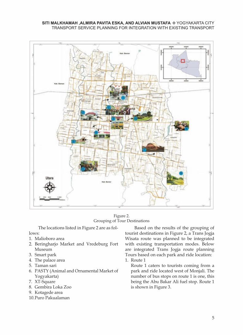
Figure 2. Grouping of Tour Destinations
The locations listed in Figure 2 are as fol-lows:1. Malioboro area2. Beringharjo Market and Vredeburg Fort
Museum3. Smart park4. The palace area5. Taman sari6. PASTY (Animal and Ornamental Market of
Yogyakarta)7. XT-Square8. Gembira Loka Zoo9. Kotagede area10. Puro Pakualaman
Based on the results of the grouping of tourist destinations in Figure 2, a Trans Jogja Wisata route was planned to be integrated with existing transportation modes. Below are integrated Trans Jogja route planning Tours based on each park and ride location:1. Route 1 Route 1 caters to tourists coming from a
park and ride located west of Monjali. The number of bus stops on route 1 is one, this being the Abu Bakar Ali fuel stop. Route 1 is shown in Figure 3.
SITI MALKHAMAH ,ALMIRA PAVITA ESKA, AND ALVIAN MUSTAFA YOGYAKARTA CITY TRANSPORT SERVICE PLANNING FOR INTEGRATION WITH EXISTING TRANSPORT
5

Figure 3. Route Map 1
2. Route 2 Route 2 serves tourists coming from a park
and ride located at the Adisucipto Airport Parking lot. Four shelters are available on Route 2, namely the local shelters, Pakualaman shelters, Senopati shelters and Abu Bakar Ali shelters. Route 2 is presented in Figure 4.
Figure 4. Route Map 2
3. Route 3 Route 3 serves tourists coming from
the park and ride located at Terminal
Giwangan. There are 6 bus stops on Route 3, namely Kotagede shelter, Gembira Loka shelter, Pakualaman shelter, Senopati shelter, Ngabean shelter and XT-Square shelter. Route 3 is shown in Figure 5.
Figure 5. Route Map 3
4. Route 4 Route 4 caters to tourists coming from a
park and ride located in Pasar Niten. The number of bus stops/shelters on Route 4 is 3 pieces, i.e. Pasty shelter 1, Ngabean shelter and Pasty shelter 2. Route 4 is shown in Figure 6.
Figure 6. Route Map 4
| VOL 8, NO.1, Desember 2018; 1-12
6
JURNAL TEKNOSAINS
Shown By Walking Distance (Connectivity)
Basuki and Malkhamah, 2009, used a matrix of the importance of performance method and the impact score method to ob-tain a priority scale as input for improve-ments to the urban transport service based on an assessment by urban transportation passengers in Yogyakarta of existing service standards and desired service expectations.
The order of the scale of importance for service performance is different between the two methods. Matrix importance performance method is useful in seeing how far the expec-
tations differ from reality that exists, based on assessment by urban transport passengers. So that can be taken as a benchmark in the scale of priority improvement based on service cri-teria that are still far from the expectations of respondents. The impact score method sepa-rates the urban transport respondents who assess the service criteria from their personal experiences, whether they have had prob-lems directly with the criteria of the service assessed. Hence, their judgment will be more profound and more detailed. The following is the order of priority scale of assessment of ser-vice criteria presented in Table 2.
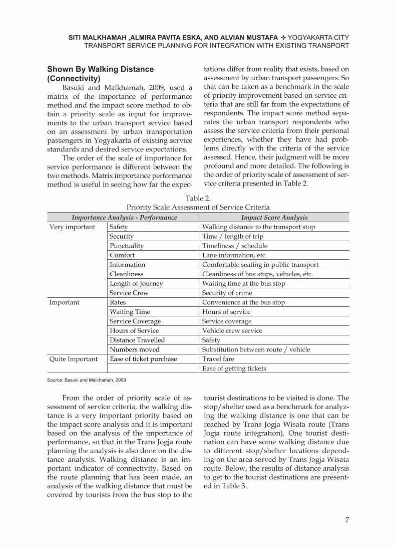
Table 2.Priority Scale Assessment of Service Criteria
Importance Analysis - Performance Impact Score AnalysisVery important Safety Walking distance to the transport stop
Security Time / length of tripPunctuality Timeliness / scheduleComfort Lane information, etc.Information Comfortable seating in public transportCleanliness Cleanliness of bus stops, vehicles, etc.Length of Journey Waiting time at the bus stopService Crew Security of crime
Important Rates Convenience at the bus stopWaiting Time Hours of serviceService Coverage Service coverageHours of Service Vehicle crew serviceDistance Travelled SafetyNumbers moved Substitution between route / vehicle
Quite Important Ease of ticket purchase Travel fareEase of getting tickets
Source: Basuki and Malkhamah, 2009
From the order of priority scale of as-sessment of service criteria, the walking dis-tance is a very important priority based on the impact score analysis and it is important based on the analysis of the importance of performance, so that in the Trans Jogja route planning the analysis is also done on the dis-tance analysis. Walking distance is an im-portant indicator of connectivity. Based on the route planning that has been made, an analysis of the walking distance that must be covered by tourists from the bus stop to the
tourist destinations to be visited is done. The stop/shelter used as a benchmark for analyz-ing the walking distance is one that can be reached by Trans Jogja Wisata route (Trans Jogja route integration). One tourist desti-nation can have some walking distance due to different stop/shelter locations depend-ing on the area served by Trans Jogja Wisata route. Below, the results of distance analysis to get to the tourist destinations are present-ed in Table 3.
SITI MALKHAMAH ,ALMIRA PAVITA ESKA, AND ALVIAN MUSTAFA YOGYAKARTA CITY TRANSPORT SERVICE PLANNING FOR INTEGRATION WITH EXISTING TRANSPORT
7

Table 3.Travel Destination Distribution Based on Walking Distance (Connectivity) *
No Walking Distance (m) Tourist Destination Halt Stop/Shelter %1 0 - 100 Area of Malioboro Abu Bakar Ali 18%
Taman Pintar SenopatiPASTY PASTY 1, 2Gembira Loka Gembira Loka
2 100 - 200 Benteng Vredeburg Senopati 5%3 200 - 300 Beringharjo Market Senopati 9%
XT-Square XT-Square4 300 - 400 Puro Pakualaman Pakualaman 5%5 > 400 Beringharjo Market Abu Bakar Ali 64%
Vredeburg FortTaman PintarKawasan KeratonTaman SariPASTYXT-SquareGembira LokaKotagede Puro PakualamanPalace Area SenopatiArea of Malioboro NgabeanBeringharjo MarketVredeburg FortTaman PintarPalace AreaTaman SariKotagede Kotagede
Total 100%* description: Good connectivity is measured by a walking distance ≤ 400 meters
Based on Table 3, it is known that most tourist sites located in Yogyakarta City have to be reached by walking more than 400 m from the stop. Stops that have a walking distance of more than 400 m to tourist des-tinations are Abu Bakar Ali stop/shelter, Se-nopati shelter, Ngabean stop, and Kotagede shelter.
Based on the Technical Guidance of Places of Public Passenger Vehicle Stops (Department of Transportation, 1996), tour-ist destinations in Yogyakarta City can be categorized as zone 2 with a maximum stop distance of 300 - 400 m so the maximum dis-tance from stop to tourist destination is 400
m. Abu Bakar Ali stop/shelter, Senopati shelter, Ngabean stop/shelter and Kotagede shelter have a walking distance of more than 400 m to the tourist destinations so that inte-gration is required in addition to integration with Trans Jogja Wisata.
One indicator of the success of DIY transportation (Malkhamah, 2014) is 75% of tourism activity centers on connection by public transport. By looking at Table 3, this indicator has not been reached, as only 36% are connected with a walking distance of ≤ 400 meters. Therefore integration needs to be done between Trans Jogja Wisata routes. Trans Jogja Wisata integrating with Trans
| VOL 8, NO.1, Desember 2018; 1-12
8
JURNAL TEKNOSAINS

Jogja and the integration of Trans Jogja Wisa-ta with Non Motorized Vehicles (KTB) de-scribed below.
Planning Trans Jogja Wisata Integration with Existing Modes of Transportation. Integration between Trans Jogja Wisata routes
To be able to reach tourist destinations that cannot be served by one route, the Trans Jogja Wisata route, planning of integration between Trans Jogja Wisata routes is need-ed. In an integration system between Trans Jogja tourist routes, passengers of Trans Jogja Wisata can switch between routes at bus stops. Below, tourist destinations that re-quire integration between Trans Jogja Wisata routes are presented in Table 4.
Table 4.Travel Destination and Integration Between Trans Jogja Wisata Routes
No Tourist Destination Early RouteTransit
Stop/Shelter Halt Route Destination Halt1. PASTY Route 3 Ngabean Route 4 PASTY 22. Kotagede Route 4 Ngabean Route 3 Kotagede3. Gembira Loka Route 4 Ngabean Route 3 Gembira Loka4. Pakualaman Route 4 Ngabean Route 3 Pakualaman
Integration of Trans Jogja Wisata with Trans Jogja
If one of the Trans Jogja Tour routes is not integrated directly with other Trans Jog-ja Tour routes but passes by the Trans Jogja network, integration between Trans Jogja Wisata and Trans Jogja can be planned to go directly to the tourist destination or to the
transit stop/halt for the Trans Jogja travel route. Trans Jogja routes that can be inte-grated with Trans Jogja Tour routes. Trans Jogja routes are paths 1A, 1B, 2A, 2B, 3A, and 3B. Integration that can occur between Trans Jogja Wisata routes and Trans Jogja routes is presented in Table 5.
Table 5. Integration that can occur between Trans Jogja Wisata Routes and Trans Jogja Routes
No Tourist Destination Early RouteTransit
Transit Halt Route Destination Halt1. Gembira Loka Route1 Abu Bakar Ali Line
1 AGedung Juang
2. Pakualaman Route 1 Abu Bakar Ali Line1A
Pakualaman
3. Taman Pintar Route 1 Abu Bakar Ali Line1A
Taman Pintar
4. Kotagede Route 1 Abu Bakar Ali Line 3A Ngabean5. PASTY Route 1 Abu Bakar Ali Line
3ANgabean
6. XT-Square Route 1 Abu Bakar Ali Line 3A Ngabean
Integration of Trans Jogja Wisata with Non-Motorized Vehicles (NMV)
To be able to reach tourist destinations that are far from Trans Jogja Wisata stops and
tourist destinations that cannot be accessed by Trans Jogja Wisata transportation due to bus restrictions, integration between Trans Jogja Wisata and Non-Motorized Vehicles in
SITI MALKHAMAH ,ALMIRA PAVITA ESKA, AND ALVIAN MUSTAFA YOGYAKARTA CITY TRANSPORT SERVICE PLANNING FOR INTEGRATION WITH EXISTING TRANSPORT
9

the form of pedicabs and horse carriges can be planned. In addition, NMV integration can be used to connect between Transit shel-ters / Trans Jogja shelters where no modes connect both. The location of NMV services is in the area of the Palace, Taman Pintar, Malioboro, Taman Sari, KH Ahmad Dahlan Street, the Flower Market, Pakualaman, XT-Square, Gembira Loka, and Kotagede. For NMV, pools can be built at Ngabean, Alun-alun Kidul (South Square), Senopati Area, Abu Bakar Ali, Pakualaman, Gembira Loka, XT-Square, Kotagede.
Integration of Trans Jogja Wisata with “si Thole”
To be able to reach tourist destinations that cannot be accessed by Trans Jogja Wisata transportation due to buses being prohibited from entering areas such as Jeron Beteng, in-tegration was planned between Trans Jogja Wisata and special transport operated by Jer-on Beteng “Thole”. The following integration that can occur between Trans Jogja Wisata routes and “si Thole” is presented in Table 6.
Table 6.Integration between Trans Jogja Tour and “si Thole”
No Tourist Destination Early RouteTransit
Transit Halt Route Thole Halt1. Taman Pintar Route 4 Ngabean Thole route 2 Senopati2. Palace Area Route 2, 3, and 4 Senopati, Ngabean Thole route 2 and 1 Palace3. Taman Sari Area Route 2, 3 Senopati Thole route 2
Thole route 1Taman Sari
Route 4 Ngabean Thole route 1
Integration between Trans Jogja Wisata, Trans Jogja, and Non Motorized Vehicles
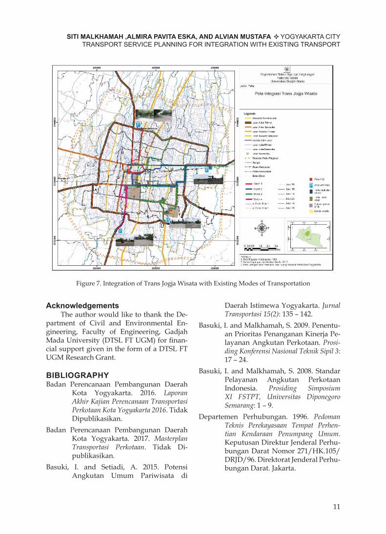
Based on the route map of Trans Jogja Wisata in Figure 3, a route network has been established to serve the routes. This route network is then integrated with ex-isting transportation modes, namely Trans Jogja, Non-Motorized Vehicles (NMV) in the form of pedicabs and horse carriages and “si Thole”. A map of Trans Jogja Wisata integra-tion with existing modes of transportation, as desrcribed above and as presented in Tables 5 and 6 is shown in Figure 7.
CONCLUSIONTrans Jogja route planning for a network
integrated with existed modes of transport is based on tourist destinations of choice ac-cording to interviews, the Tourism Destina-tion Guide to Yogyakarta Special Region as well as locations that allow integration. Each park and ride is served by 1 route so there
are 4 routes serving Route 1, Route 2, Route 3, and Route 4.
The distance analysis is based on a route map of Trans Jogja Wisata. Abu Bakar Ali shelter, Senopati shelter, Ngabean shelter and Kotagede shelter have walking distances of more than 400 m to the tourist destinations so that integration is required in addition to integration with Trans Jogja Wisata.
The Trans Jogja Wisata route network is integrated with the existing transportation modes of Trans Jogja, Non-Motorized Vehi-cles (NMV) in the form of pedicabs and horse carriages and “si Thole”. Zoning of service area KTB was conducted so as not to impede the flow of other vehicle traffic. This integra-tion is to achieve the connection indicator of 75% of tourist destinations (connectivity) based on Malkhamah (2014).
Implementation of the planning in this research result is suggested, with continued monitoring and evaluation so that comfort-able and affordable travel to tourist destina-tions can be fulfilled and traffic jams reduced.
| VOL 8, NO.1, Desember 2018; 1-12
10
JURNAL TEKNOSAINS
AcknowledgementsThe author would like to thank the De-
partment of Civil and Environmental En-gineering, Faculty of Engineering, Gadjah Mada University (DTSL FT UGM) for finan-cial support given in the form of a DTSL FT UGM Research Grant.
BIBLIOGRAPHYBadan Perencanaan Pembangunan Daerah
Kota Yogyakarta. 2016. Laporan Akhir Kajian Perencanaan Transportasi Perkotaan Kota Yogyakarta 2016. Tidak Dipublikasikan.
Badan Perencanaan Pembangunan Daerah Kota Yogyakarta. 2017. Masterplan Transportasi Perkotaan. Tidak Di-publi kasi kan.
Basuki, I. and Setiadi, A. 2015. Potensi Angkutan Umum Pariwisata di
Daerah Istimewa Yogyakarta. Jurnal Transportasi 15(2): 135 – 142.
Basuki, I. and Malkhamah, S. 2009. Penentu-an Prioritas Penanganan Kinerja Pe-layanan Angkutan Perkotaan. Prosiding Konferensi Nasional Teknik Sipil 3: 17 – 24.
Basuki, I. and Malkhamah, S. 2008. Standar Pelayanan Angkutan Perkotaan Indonesia. Prosiding Simposium XI FSTPT, Universitas Diponegoro Semarang: 1 – 9.
Departemen Perhubungan. 1996. Pedoman Teknis Perekayasaan Tempat Perhentian Kendaraan Penumpang Umum. Keputusan Direktur Jenderal Per hu-bungan Darat Nomor 271/HK.105/DRJD/96. Direktorat Jenderal Perhu-bungan Darat. Jakarta.
Figure 7. Integration of Trans Jogja Wisata with Existing Modes of Transportation
SITI MALKHAMAH ,ALMIRA PAVITA ESKA, AND ALVIAN MUSTAFA YOGYAKARTA CITY TRANSPORT SERVICE PLANNING FOR INTEGRATION WITH EXISTING TRANSPORT
11
Departemen Perhubungan Republik Indo nesia. 2002. Pedoman Teknis Penyelenggaraan Angkutan Penumpang Umum di Wilayah Perkotaan Dalam Trayek Tetap dan Teratur. Keputusan Direktur Jenderal Perhubungan Darat Nomor SK.687/AJ.206/DRJD/2002. Direktorat Jenderal Perhu bungan Darat. Jakarta.
Dinas Pariwisata Daerah Istimewa Yogya-karta. 2017. Destinasi Wisata Jogja. Dinas Pariwisata DIY. Yogyakarta.
Dinas Pariwisata Daerah Istimewa Yogyakarta. 2017. Statistik Kepariwisa ta an 2016. Dinas Pariwisata DIY. Yogyakarta.
Kementerian Perhubungan. 2015. Studi Sistranas Pada Tataran Transportasi Lokal (Tatralok) di Kota Yogyakarta. Sekretariat Badan Penelitian dan Pengembangan Perhubungan. Jakarta.
Malkhamah. 2014. Transportasi sebagai Sumber Permasalahan atau sebagai Motor Penggerak Perekonomian dan Kehidupan Masyarakat. Dalam Bunga Rampai Dewan riset daerah DIY 2014. Pemerintah Daerah Istimewa Yogyakarta dan DRD DIY.
Peraturan Daerah Kota Yogyakarta Nomor 4 Tahun 2010. Penyelenggaraan Kepariwisataan. 2 Juli 2010. Lembaran Daerah Kota Yogyakarta Tahun 2010 Nomor 4. Yogyakarta.
Peraturan Daerah Provinsi Daerah Istimewa Yogyakarta Nomor 1 Tahun 2012. Rencana Induk Pembangunan Kepariwisataan Daerah Provinsi Daerah Istimewa Yogyakarta Tahun 2012 2025. 14 Maret 2012. Lembaran Daerah Provinsi Daerah Istimewa Yogyakarta Tahun 2012 Nomor 1. Yogyakarta.
Peraturan Pemerintah Republik Indonesia Nomor 74 Tahun 2014. Angkutan Jalan. 14 Oktober 2014. Lembaran Negara Republik Indonesia Tahun 2014 Nomor 260. Jakarta.
| VOL 8, NO.1, Desember 2018; 1-12
12
JURNAL TEKNOSAINS