laporan praktek lapangan akhir pemetaan geologi pegunungan jiwo bayat
DESCRIPTION
assssssssssssssssdddddddddddddddddTRANSCRIPT
LAPORAN PEMETAAN GEOLOGI DAERAH PERBUKITAN JIWO TIMURKECAMATAN BAYAT
KABUPATEN KLATEN
PEMETAAN GEOLOGI BAYAT 2012
Disusun Oleh:
AGUSTINA PUTRI P. (XII GPA/12966)
CATUR GUNAWAN (XII GPA/12982)
CYRILUS ARYO YUNANTO (XII GPA/12983)
FAJAR ANANG PRASETYA (XII GPA/12991)
RIZKY DARMAWAN (XII GPB/13016)
YANUARDHI SATRIA N. (XII GPB/13023)
PROGRAM KEAHLIAN GEOLOGI PERTAMBANGAN
SMK NEGERI 2 DEPOK SLEMAN YOGYAKARTA
2012
LEMBAR PENGESAHAN
Diajukan Guna Memenuhi Persyaratan Kelulusan Mata Jurusan Perpetaan dan Kenaikan ke Kelas XIII yang Diselenggarakan oleh Program Keahlian Geologi
Pertambangan SMK Negeri 2 Depok Sleman
Yogyakarta, 5 Juni 2012
Penyusun Kelas/NIS Tanda tanganAGUSTINA PUTRI P. (XII GPA/12966) 1.CATUR GUNAWAN (XII GPA/12982) 2.CYRILUS ARYO YUNANTO (XII GPA/12983) 3.FAJAR ANANG PRASETYA (XII GPA/12991) 4.RIZKY DARMAWAN (XII GPB/13016) 5.YANUARDHI SATRIA N. (XII GPB/13023) 6.
Menyetujui,
KPK Geologi Pertambangan
Drs. Agung Widyatmoko, M. Pd.NIP. 19611006 198803 1 004
Guru Pembimbing
HeriNIP.
2LAPORAN PRAKTIKUM JIWO TIMUR BAYAT
KATA PENGANTAR
Assalamu'alaikum wr.wb.
Dengan mengucap puji syukur kehadirat Allah SWT yang telah melimpahkan rahmat dan Hidayah-Nya, sehingga "LAPORAN PEMETAAN GEOLOGI DAERAH PERBUKITAN JIWO TIMUR KECAMATAN BAYAT KABUPATEN KLATEN" ini dapat kami selesaikan dengan baik dan tepat pada waktunya.
Dalam penyelesaian laporan ini tentunya tidak dapat kami selesaikan sendiri, kami mendapatkan bantuan dari berbagai pihak, untuk itu kami mengucap syukur dan terima kasih kepada:
1. Allah SWT atas segala rahmat dan hidayah-Nya sehingga laporan ini dapat terselesaikan.2. Orang tua yang memberikan dukungan moril maupun materiil.3. Segenap Gurupembimbing yang telah membimbing kami dalam praktik pemetaan di lapangan
maupun ketika pembelajaran teori di laboratorium.4. HAMMAST (Himpunan Alumni Mahasiswa Stembayo) yang telah memberikan dukungan dan
pengarahannya yang baik kepada kami.5. Semua pihak yang membantu proses penyelesaian laporan ini.
Tiada gading yang tak retak, sebagaimana laporan kami pun tidak terlepas dari kesalahan dan kekurangan,untuk itu kritik dan saran yang bersifat konstruktif sangat kami harapkandemi kesempurnaan laporan dimasa mendatang.
Semoga laporan ini dapat bermmanfaat bagi kita semua,.Amin.
Wassalamu'alaikum wr.wb.
Yogyakarta, Mei 2012
Penyusun
3LAPORAN PRAKTIKUM JIWO TIMUR BAYAT
SARI
Bayat adalah sebuah kecamatan di Kabupaten Klaten, Jawa Tengah. Kecamatan ini berbatasan dengan Kabupaten Gunung Kidul, Daerah Istimewa Yogyakarta di sebelah selatan. Bayat memiliki luas 39,43 km2dengan jumlah penduduk ±56.040 jiwa.
Secara fisiografis Perbukitan Bayat merupakan suatu inlier dari batuan Pra Tersier dan Tersier di sekitar endapan Kuarter, yang terutama terdiri dari endapan flufio-vulkanik dari Merapi.Elevasi tertinggi dari puncak-puncak yang ada tidak lebih dari 400 meter diatas muka laut, sehingga perbukitan tersebut dapat disebut perbukitan rendah.Perbukitan itu tersebar menurut jalur yang arahnya berbeda. Di bagian barat (Jiwo Barat), jalur puncak-puncak bukit berarah utara selatan, yang diwakili oleh puncak-puncak Jabalkat, Kebo, Merak, Cakaran, Budo Sari, dan Tugu dengan di bagian paling utara membelok ke arah barat, yaitudaerah perbukitan Kampak. Di sebelah timur (Jiwo Timur) arah jalurnya adalah barat-timur, dengan puncak-puncak Konang, Pendul dan Temas, dengan percabangan kearah utara, yang terwakili oleh puncak Jokotuo dan Bawak.
Urutan– urutan stratigrafi mulai dari satuan Metamorfi berumur Pre Tersier sampai satuan berumur Miosen Tengah tersingkap dengan baik. Di Perbukitan Jiwo, di atas Satuan Morfologi berumur Pra Tersier terletak secara tidak selaras satuan-satuan batugamping dan batupasir laut dangkal yang berumur Eosen Tengah, Formasi Wungkal, dan Formasi Gamping. Secara tidak selaras di atas Formasi Gamping terletak satuan-satuan endapan turbidit laut dalam yang berumur Oligosen Akhir sampai Miosen Awal ( zona N.2 – N8) yaitu formasi Kebo, Formasi Butak, Formasi Semilir, dan Formasi Nglanggran, satuan-satuan mana terletak pada zona Pegunungan Selatan Jawa Timur. Semua satuan tersebut, secara tidak selaras ditutupi oleh satuan batugamping yang berumur Mosen Tengah ( zona N-12), yaitu Formasi Oyo. Di Daerah penelitian juga terjadi pengintrusian diorit dan diabas diperkirakan terjadi pada awal Miosen Tengah dan intrusi diorit yang diperkirakan terjadi pada kala Pliosen.Struktur-struktur geologi yang berkembang di daerah penelitian adalah struktur lipatan dan sesar-sesar naik, turun, dan sesar mendatar. Struktur Geologi tersebut berkembang diperkirakan akibat bekerjanya gaya kompresi berarah hampir utara-selatan yang kemungkinan berlangsung dalam dua periode, pada awal kala Miosen Tengah sebelum Formasi Oyo diendapkan dan pada kala Pliosen setelah Formasi Oyo diendapkan. Bahan Galian yangterdapat di daerah penelitian yang memiliki nilai ekonomis adalah marmer,batugamping, lempung, breksi tufaandanbatuanbeku.
4LAPORAN PRAKTIKUM JIWO TIMUR BAYAT
DAFTAR ISI
Halaman Judul........................................................................................................................
Halaman Pengesahan.............................................................................................................
Kata Pengantar.......................................................................................................................
Sari..........................................................................................................................................
Daftar Isi.................................................................................................................................
Daftar Gambar........................................................................................................................
Bab I Pendahuluan
I.1 Latar Belakang..............................................................................................................8
I.2 Maksud dan Tujuan......................................................................................................8
I.3 Waktu dan Lokasi.........................................................................................................9
I.4 Peralatan......................................................................................................................9
I.5 Darsar Toeri…..............................................................................................................10
Bab II Geologi Regional
II.1 Geomorfologi………………………………………………………………………….20
II.2 Stratigrafi… ………………………………………………………………………..23
II.3 Structure Regional… ………………………………………………………………24
Bab III Data, Analisa
III.1 Data… ……………………………………………………………………………………26
III.2 Analisa……………………………………………………………………………………….54
Bab IV Penutup…………………………………………………………………………………………..57
5LAPORAN PRAKTIKUM JIWO TIMUR BAYAT
DAFTAR GAMBAR
Gambar 10.2 : Ekspresi Hukum “V”
Gambar 10.3 : Pendekatan real Ekspresi Hukum “V” pada blok peta kontur
Gambar 10.4 : Cara mendapatkan apparent dip dengan Alignment Diagram
Gambar 10.5 : Kenampakan penyebaran batuan pada penampang tegak lurus strike dan kenampakan urutan stratigrafinya
Gambar 10.6 : Peta geologi terintegrasi
Gambar 2.0 : singkapan gamping
Gambar 2.1 : Singkapan batuan Joko Tuo
Gambar 2.2 :kenampakan singkapan di belakang Puskesmas
Gambar 2.3 : batuan gamping di temas
Gambar 2.4 : singkapan di gunung lanang
Gambar 2.5 : singkapan di belakang SMA Bayat
Gambar 2.6 : singkapan gamping numulite
Gambar 2.7 : singkapan lanau di Pendhul
6LAPORAN PRAKTIKUM JIWO TIMUR BAYAT
BAB I
PENDAHULUAN
A. Latar Belakang
Permukaan bumi merupakan salah satu bagian yang harus dipelajari dalam penguasaan
ilmu geologi karena ekspresi topografi dapat menunjukkan keadaan geologi baik struktur
maupun litologinya. Dengan demikian, geomorfologi sangat terkait dalam mempelajari geologi
struktur. Bentukan-bentukan morfologi yang kita jumpai sekarang merupakan hasil dari gaya
yang bekerja baik itu berasal dari dalam maupun dari luar bumi. Bentukan-bentukan tersebut
akan berbeda-beda bentuknya tergantung dari sistem yang mempengaruhinya. Misalnya,
perkembangan sistem tektonik di suatu daerah akan memberikan konstribusi bagi
perkembangan struktur geologi yang secara langsung maupun tidak langsung akan terilustrasi
dipermukaan.
Pada sisi lain litologi juga berperan dalam mengekspresikan topografi. Nilai resisten dan
tidaknya litologi akan memberikan relief yang berbeda-beda di permukaan. Litologi yang keras
(resisten) cenderung membentuk relief yang lebih menonjol (tinggi) daripada daerah dengan
litologi yang lebih lunak (kurang resisten). Misalnya daerah yang disusun oleh litologi
batugamping (resisten) akan membentuk suatu pola bentang alam "karst topography" sebagai
pola yang sangat khas (tersendiri). Bentukan yang berlainan dari kedudukan litologi dan bentuk
morfologi mengakibatkan terbentuknya pola penyebaran litologi di permukaan atau disebut
pola singkapan.
Dalam membaca dan memahami dasar-dasar pembuatan peta geologi dibutuhkan pengertian
unsur-unsur pendukung peta geologi.
B. Maksud dan tujuan
a. Memahami definisi peta geologi dan unsur-unsurnya.
b. Memahami pola singkapan, tebal, kedalaman dan pembuatan penampang geologi
c. Membaca dan memahami dasar-dasar pembuatan peta geologi.
7LAPORAN PRAKTIKUM JIWO TIMUR BAYAT
C. Letak dan Kesampaian Daerah
Lokasi praktek lapangan ini di daerah prbukitan jiwo timur, bayat, klaten, jawa
tengah.Siswa mengunakan kendaraan bermotor untuk mencapai lokasi tersebut. Jarak antara
stm pembangunan dengan lokasi praktek berkisar kurang lebih 80km. Jarak tersebut dapat
dicapai dengan waktu satu setengah jam dengan kecepatan rata rata 70 km/jam. Kegiatan
praktek dilaksanakan selama lima hari. Siswa menjadikan rumah penduduk sebagai basecamp
selama lima hari kerja. Selama praktek siswa juga menggunakan kendaraan bermotor (jika
medan memungkinkan) untuk mempersingkat waktu perjalanan.
D. Peralatan kerja
1. Sepatu lapangan2. Pakaian lapangan3. Palu geologi4. Kompas geologi5. Hardboard6. Alat tulis7. Spidol8. Kantong sampel9. Busur, penggaris10. Peta topografi11. Kendaraan bermotor12. Palu geologi13. GPS (global positioning sistem)14. Alat komunikasi15. Kalkulator16. Meteran
8LAPORAN PRAKTIKUM JIWO TIMUR BAYAT
E. DASAR TEORI
DEFINISI
a. Pemetaan
Pemetaan adalah proses pengukuran, perhitungan dan penggambaran permukaan bumi (terminologi geodesi) dengan menggunakan cara dan atau metode tertentu sehingga didapatkan hasil berupa softcopy maupun hardcopypeta yang berbentuk vektor maupun raster.
b. Peta geologi
Peta geologi adalah bentuk informasi geologi suatu daerah / wilayah / kawasan dengan tingkat
kualitas yang tergantung pada skala peta dan menggambarkan informasi tektonik, stratigrafi,
struktur, jenis dan sifat batuan yang disajikan dalam bentuk gambar dengan warna, simbol dan
corak atau gabungan ketiganya.
c. Pola singkapan
Perpotongan antara bidang litologi dan bidang permukaan bumi.
d. Peta lintasan
Suatu peta yang menggambarkan lintasan, lokasi pengamatan, dan hasil pengamatan lapangan
(litologi, struktur, pengambilan sample dan gejala geologi yang lain, misalnya mata air, gerakan
tanah, penambangan).
e. Penampang geologi
Gambaran secara vertikal bawah permukaan geologi suatu daerah, sehingga dari gambaran ini
akan diketahui hubungan antara satu dengan yang lain.
f. Legenda
Keterangan litologi yang disusun secara stratigrafis.
g. Keterangan
9LAPORAN PRAKTIKUM JIWO TIMUR BAYAT
Menjelaskan simbol-simbol dalam peta.
h. Tebal lapisan
Jarak terpendek antara dua bidang sejajar yang merupakan batas bawah dan atas (top &
bottom) lapisan tersebut.
i. Kedalaman
Jarak vertikal dari ketinggian tertentu (umumnya permukaan bumi) ke arah bawah terhadap
suatu titik, garis atau bidang.
Hukum "V" (V Rule)
Hukum ini menyatakan hubungan antara lapisan yang mempunyai kemiringan dengan
relief topografi yang menghasilkan suatu pola singkapan. Hukum tersebut sebagai berikut :
10LAPORAN PRAKTIKUM JIWO TIMUR BAYAT
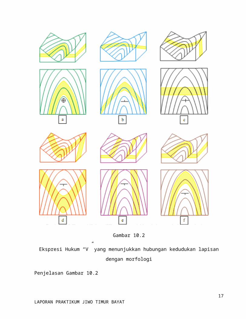
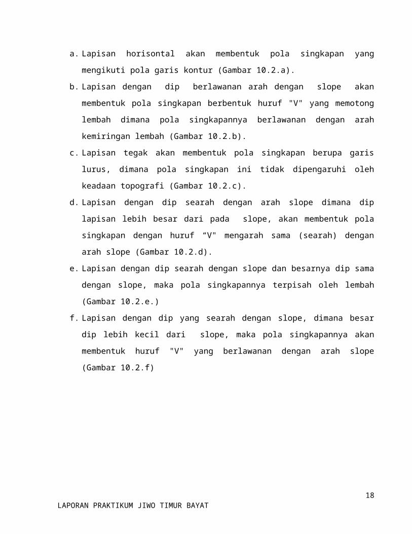
Gambar 10.2
Ekspresi Hukum “V” yang menunjukkan hubungan kedudukan lapisan dengan morfologi
Penjelasan Gambar 10.2
a. Lapisan horisontal akan membentuk pola singkapan yang mengikuti pola garis kontur
(Gambar 10.2.a).
11LAPORAN PRAKTIKUM JIWO TIMUR BAYAT
b. Lapisan dengan dip berlawanan arah dengan slope akan membentuk pola singkapan
berbentuk huruf "V" yang memotong lembah dimana pola singkapannya berlawanan
dengan arah kemiringan lembah (Gambar 10.2.b).
c. Lapisan tegak akan membentuk pola singkapan berupa garis lurus, dimana pola singkapan
ini tidak dipengaruhi oleh keadaan topografi (Gambar 10.2.c).
d. Lapisan dengan dip searah dengan arah slope dimana dip lapisan lebih besar dari pada
slope, akan membentuk pola singkapan dengan huruf “V" mengarah sama (searah)
dengan arah slope (Gambar 10.2.d).
e. Lapisan dengan dip searah dengan slope dan besarnya dip sama dengan slope, maka pola
singkapannya terpisah oleh lembah (Gambar 10.2.e.)
f. Lapisan dengan dip yang searah dengan slope, dimana besar dip lebih kecil dari slope,
maka pola singkapannya akan membentuk huruf "V" yang berlawanan dengan arah slope
(Gambar 10.2.f)
12LAPORAN PRAKTIKUM JIWO TIMUR BAYAT
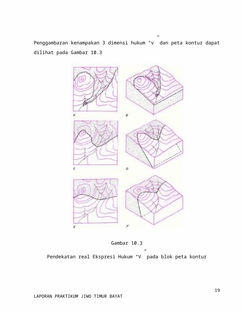
Penggambaran kenampakan 3 dimensi hukum “v” dan peta kontur dapat dilihat pada Gambar
10.3
Gambar 10.3
Pendekatan real Ekspresi Hukum “V” pada blok peta kontur
13LAPORAN PRAKTIKUM JIWO TIMUR BAYAT

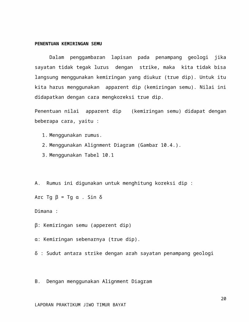
PENENTUAN KEMIRINGAN SEMU
Dalam penggambaran lapisan pada penampang geologi jika sayatan tidak tegak lurus
dengan strike, maka kita tidak bisa langsung menggunakan kemiringan yang diukur (true dip).
Untuk itu kita harus menggunakan apparent dip (kemiringan semu). Nilai ini didapatkan dengan
cara mengkoreksi true dip.
Penentuan nilai apparent dip (kemiringan semu) didapat dengan beberapa cara, yaitu :
1. Menggunakan rumus.
2. Menggunakan Alignment Diagram (Gambar 10.4.).
3. Menggunakan Tabel 10.1
A. Rumus ini digunakan untuk menghitung koreksi dip :
Arc Tg β = Tg α . Sin δ
Dimana :
β: Kemiringan semu (apperent dip)
α: Kemiringan sebenarnya (true dip).
δ : Sudut antara strike dengan arah sayatan penampang geologi
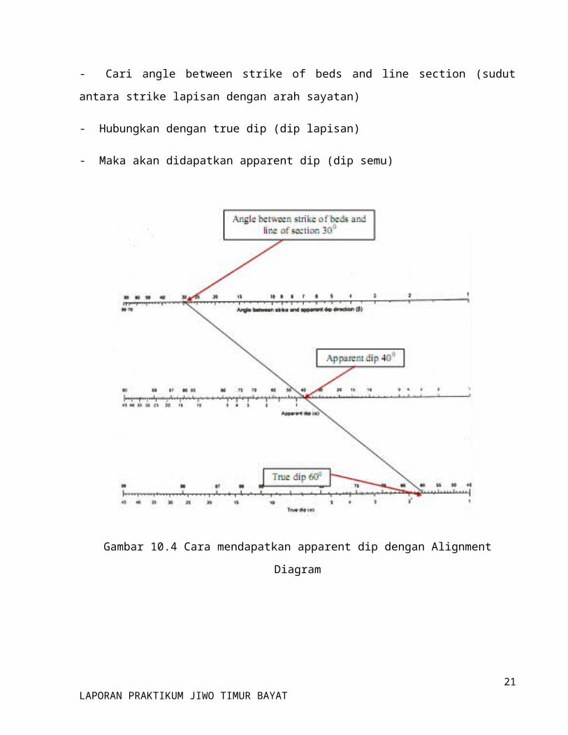
B. Dengan menggunakan Alignment Diagram
- Cari angle between strike of beds and line section (sudut antara strike lapisan dengan arah
sayatan)
- Hubungkan dengan true dip (dip lapisan)
- Maka akan didapatkan apparent dip (dip semu)
14LAPORAN PRAKTIKUM JIWO TIMUR BAYAT
Gambar 10.4 Cara mendapatkan apparent dip dengan Alignment Diagram
15LAPORAN PRAKTIKUM JIWO TIMUR BAYAT
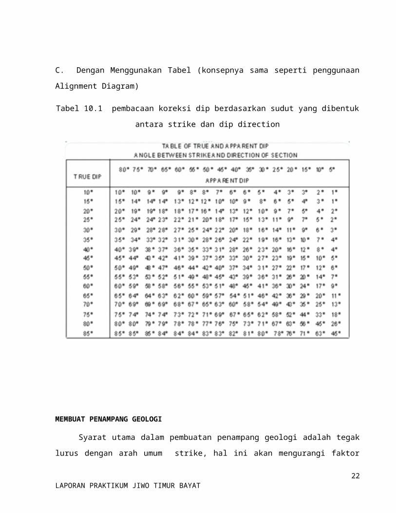
C. Dengan Menggunakan Tabel (konsepnya sama seperti penggunaan Alignment Diagram)
Tabel 10.1 pembacaan koreksi dip berdasarkan sudut yang dibentuk antara strike dan dip
direction
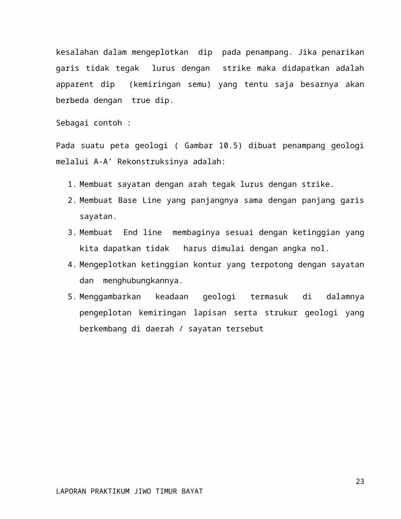
MEMBUAT PENAMPANG GEOLOGI
Syarat utama dalam pembuatan penampang geologi adalah tegak lurus dengan arah umum
strike, hal ini akan mengurangi faktor kesalahan dalam mengeplotkan dip pada penampang. Jika
penarikan garis tidak tegak lurus dengan strike maka didapatkan adalah apparent dip
(kemiringan semu) yang tentu saja besarnya akan berbeda dengan true dip.
Sebagai contoh :
16LAPORAN PRAKTIKUM JIWO TIMUR BAYAT
Pada suatu peta geologi ( Gambar 10.5) dibuat penampang geologi melalui A-A’
Rekonstruksinya adalah:
1. Membuat sayatan dengan arah tegak lurus dengan strike.
2. Membuat Base Line yang panjangnya sama dengan panjang garis sayatan.
3. Membuat End line membaginya sesuai dengan ketinggian yang kita dapatkan tidak
harus dimulai dengan angka nol.
4. Mengeplotkan ketinggian kontur yang terpotong dengan sayatan dan
menghubungkannya.
5. Menggambarkan keadaan geologi termasuk di dalamnya pengeplotan kemiringan lapisan
serta strukur geologi yang berkembang di daerah / sayatan tersebut
Gambar 10.5
Kenampakan penyebaran batuan pada penampang tegak lurus strike dan kenampakan urutan
stratigrafinya
17LAPORAN PRAKTIKUM JIWO TIMUR BAYAT
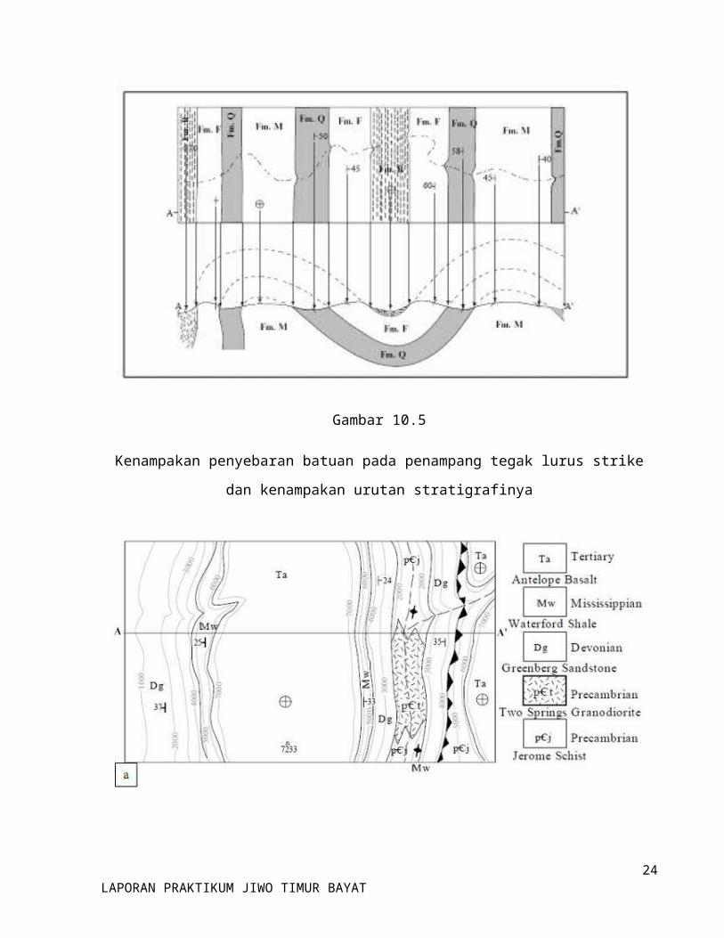
Gambar 10.6
a) Peta geologi terintegrasi dengan, b) penampang geologi, c) kolomstratigrafi
18LAPORAN PRAKTIKUM JIWO TIMUR BAYAT
BAB II
GEOLOGI REGIONAL DAERAH BAYAT
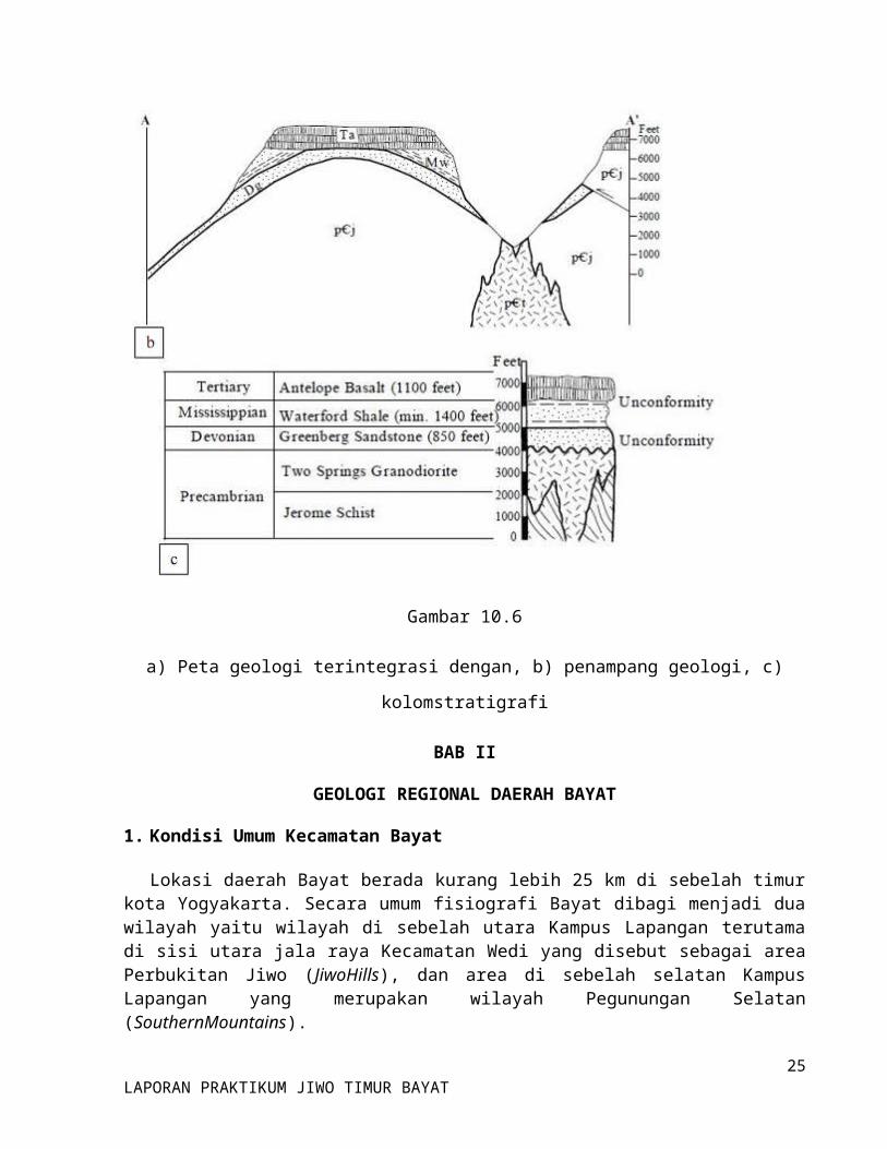
1. Kondisi Umum Kecamatan Bayat
Lokasi daerah Bayat berada kurang lebih 25 km di sebelah timur kota Yogyakarta. Secara umum fisiografi Bayat dibagi menjadi dua wilayah yaitu wilayah di sebelah utara Kampus Lapangan terutama di sisi utara jala raya Kecamatan Wedi yang disebut sebagai area Perbukitan Jiwo (JiwoHills), dan area di sebelah selatan Kampus Lapangan yang merupakan wilayah Pegunungan Selatan (SouthernMountains).
2. Geomorfologi Regional
a. Perbukitan Jiwo
Perbukitan Jiwo merupakan inlier dari batuan Pre-Tertiary dan Tertiary di sekitar endapan Quartenary, terutama terdiri dari endapan fluvio-volcanic yang berasal dari G. Merapi.Elevasi tertinggi dari puncak-puncak yang ada tidak lebih dari 400 m di atas muka air laut, sehingga perbukitan tersebut merupakan suatu perbukitan rendah.
Perbukitan Jiwo dibagi menjadi dua wilayah yaitu Jiwo Barat dan Jiwo Timur yang keduanya dipisahkan oleh Sungai Dengkeng secara antecedent.Sungai Dengkeng sendiri mengalir mengitari komplek Jiwo Barat, semula mengalir ke arah South-Southwest, berbelok ke arah East kemudian ke North memotong perbukitan dan selanjutnya mengalir ke arah Northeast.Sungai Dengkeng ini merupakan pengering utama dari dataran rendah di sekitar Perbukitan Jiwo.Pembagian fisiografi daerah Bayat di mana Perbukitan Jiwo Barat dan Timur dipisahkan oleh Sungai Dengkeng
Dataran rendah ini semula merupakan rawa-rawa yang luas akibat air yang mengalir dari lembah G. Merapi tertahan oleh Pegunungan Selatan.Genangan air ini, di utara Perbukitan Jiwo mengendapkan pasir yang berasal dari lahar. Sedangkan di selatan atau pada bagian lekukan antarbukit di Perbukitan Jiwo merupakan endapan air tenang yang berupa lempung hitam, suatu sedimen Merapi yang subur ini dikeringkan (direklamasi) oleh pemerintah Kolonial Belanda untuk dijadikan daerah perkebunan. Reklamasi ini dilakukan degan cara membuat saluran-saluran yang ditanggul cukup tinggi sehingga air yang datang dari arah G. Merapi akan tertampung di sungai sedangkan daerah dataran rendahnya yang semula berupa rawa-rawa berubah menjadi tanah kering yang digunakan untuk perkebunan. Sebagian dari rawayang semula luas itu disisakan di daerah yang dikelilingi Puncak Sari, Tugu, dan Kampak di Jiwo Barat, dikenal sebagai Rawa Jombor.Rawa yang disisakan itu berfungsi sebagai tendon untuk keperluan irigasi darah perkebunan di dataran sebelah utara Perbukitan Jiwo Timur.
Untuk mengalirakan air dari rawa-rawa tersebut, dibuat saluran buatan dari sudut Southwest rawa-rawa menembus perbukitan batuan metamorfik di G. Pegat mengalir ke timur melewati Desa Sedan dan memotong Sungai Dengkeng lewat aqueduct di sebelah seatan Jotangan menerus ke arah timur.
19LAPORAN PRAKTIKUM JIWO TIMUR BAYAT
Daerah perbukitan yang tersusun oleh batugamping menunjukkan perbukitan memanjang dengan punggung yang tumpul sehingga kenampakan punca-puncak tidak begitu nyata.Tebing-tebing perbukitannya tidak terlalu terbiku sehingga alur-alurnya tidak banyak dijumpai (Perbukitan Bawak-Temas di Jiwo Timur dan Tugu-Kampak di Jiwo Barat).Untuk daerah yang tersusun oleh batuan metamorfik perbukitannya menunjukkan relief yang lebih nyata dengan tebing-tebing yang terbiku kuat.Kuatnya hasil penorehan tersebut menghasilkan akumulasi endapan hasil erosi di kaki perbukitan ini yang dikenal sebagai colluvial.Puncak-puncak perbukitan yang tersusun dari batuan metamorfik terlihat menonjol dan beberapa diantaranya cenderung berbentuk kerucut seperti puncak Jabalkat dan puncak Semanggu.Daerah degan relief kuat ini dijumpai daerah Jiwo Timur mulai dari puncak Konang kea rah timur hingga puncak Semanggu dan Jokotuo.Daerah di sekitar puncak Pendul merupakan satu-satunya tubuh bukit yang seluruhnya tersusun oleh batuan beku.Kondisi morfologinya cukup kasar mirip perbukitan metamorfik namun relief yang ditunjukkan puncaknya tidak sekuat perbukitan metamorfik.
a) Daerah Jiwo Barat
Jiwo Barat terdiri dari deretan perbukitan G. Kampak, G. Tugu, G. Sari, G. Kebo, G. Merak, G. Cakaran, dan G. Jabalkat. G. Kampak dan G. Tugu memiliki litologi batugamping berlapis, putih kekuningan, kompak, tebal lapisan 20 – 40 cm. Di daerah G. Kampak batugamping tersebut sebagian besar merupakan suatu tubuh yang massif, menunjukkan adanya asosiasi dengan kompleks terumbu (reef). Di antara G. Tugu dan G. Sari batugamping tersebut mengalami kontak langsung dengan batuan metamorfik (mica schist).
Daerah Jiwo Barat memiliki puncak-puncak bukit berarah utara-selatan yang diwakili oleh puncak Jabalkat, Kebo, Merak, Cakaran, Budo, Sari, dan Tugu dengan di bagian paling utara membelok ke arah barat yaitu G. Kampak.
Batuan metamorf di daerah ini mencakup daerah di sekitar G. Sari, G. Kebo, G. Merak, G. Cakaran, dan G. Jabalkat yang secara umum berupa sekis mika, filit, dan banyak mengandung mineral kuarsa. Di sekitar daerah G. Sari, G. Kebo, dan G. Merak pada sekis mika tersebut dijumpai bongkah-bongkah andesit dan mikrodiorit. Zona-zona lapukannya berupa spheroidal weathering yang banyak dijumpai di tepi jalan desa. Batuan beku tersebut merupakan batuan terobosan yang mengenai tubuh sekis mika .singkapan yang baik dijumpai di dasar sungai-sungai kecil yang menunjukkan kekar kolom (columnar joint).
Batuan metamorfik yang dijumpai juga berupa filit sekis klorit, sekis talk, terdapat mieral garnet, kuarsit serta marmer di sekitar G. Cakaran, dan G. Jabalkat. Sedangkan pada bagian puncak dari kedua bukit itumasih ditemukan bongkah-bongkah konglomerat kuarsa. Sedangkan di sebelah barat G. Cakaran pada area pedesaan di tepian Rawa Jombor masih dapat ditemukan sisa-sisa konglomerat kuarsa serta batupasir. Sampai saat ini batuan metamorfik tersebut ditafsirkan sebagai batuan berumur Pre-Tertiary, sedagkan batupasir dan konglomerat dimasukkan ke dalam Formasi Wungkal.
Di daerah ini dijumpai dua inlier (isolated hill) masing-masing di bukit Wungkal dan bukit Salam.Bukit Wungkal semakin lama semakin rendah akibat penggalian penduduk untuk mengambil batu asah (batu wungkal) yang terdapat di bukit tersebut.
20LAPORAN PRAKTIKUM JIWO TIMUR BAYAT
b) Daerah Jiwo Timur
Daerah ini mencakup sebelah timur Sungai Dengkeng yang merupakan deretan perbukitan yang terdiri dari Gunung Konang, Gunung Pendul, Gunung Semangu, Di lereng selatan Gunung Pendul hingga mencapai bagian puncak, terutama mulai dari sebelah utara Desa Dowo dijumpai batu pasir berlapis, kadang kala terdapat £ragmen sekis mika ada di dalamnya. Sedangkan di bagian timur Gunung Pendul tersingkap batu lempung abu-abu berlapis, keras, mengalami deformasi lokal secara kuat hingga terhancurkan.
Hubungan antar satuan batuan tersebut masih memberikan berbagai kemungkinan karena kontak antar satuan terkadang tertutup oleh koluvial di daerah dataran.Kepastian stratigrafis antar satuan batuan tersebut barn dapat diyakini jika telah ada pengukuran umur absolut.Walaupun demikian berbagai pendekatan penyelidikan serta rekontruksi stratigrafis telah banyak dilakukan oleh para ahli.
Daerah perbukitan Jiwo Timur mempunyai puncak-puncak bukit berarah barat-timur yang diwakili oleh puncak-puncak Konang, Pendul dan Temas, Gunung J okotuo dan Gunung T emas.
Gunung Konang dan Gunung Semangu merupakan tubuh batuan sekis-mika, berfoliasi cukup baik, sedangkan Gunung Pendul merupakan tubuh intrusi mikrodiorit.Gunung Jokotuo merupakan batuan metasedimen (marmer) dimana pada tempat tersebut dijumpai tanda-tanda struktur pense saran.Sedangkan Gunung Temas merupakan tubuh batu gamping berlapis.
Di sebelah utara Gunung Pendul dijumpai singkapan batu gampmg nummulites, berwarna abu-abu dan sangat kompak, disekitar batu gamping nummulites tersebut terdapat batu pasir berlapis.Penyebaran batugamping nummulites dijumpai secara setempat-setempat terutam di sekitar desa Padasan, dengan percabangan ke arah utara yang diwakili oleh puncak Jokotuo dan Bawak.
Di bagian utara dan tenggara Perbukitan Jiwo timur terdapat bukit terisolir yang menonjol dan dataran aluvial yang ada di sekitamya.Inlier (isolited hill) ini adalah bukit Jeto di utara dan bukit Lanang di tenggara.Bukit Jeto secara umum tersusun oleh batu gamping Neogen yang bertumpu secara tidak selaras di atas batuan metamorf, sedangkan bukit Lanang secara keseluruhan tersusun oleh batu gamping Neogen.
21LAPORAN PRAKTIKUM JIWO TIMUR BAYAT
3. Statigrafi Regional
Batuan tertua yang tersingkap di daerah Bayat terdiri dari batuan metamorf berupa filtit, sekis, batu sabak dan marmer.Penentuan umur yang tepat untuk batuan malihan hingga saat ini masih belum ada.Satu-satunya data tidak langsung untuk perkiraan umurnya adalah didasarkan fosil tunggal Orbitolina yang diketemukan oleh Bothe (1927) di dalam fragmen konglomerat yang menunjukkan umur Kapur.Dikarenakan umur batuan sedimen tertua yang menutup batuan malihan tersebut berumur awal Tersier (batu pasir batu gamping Eosen), maka umur batuan malihan tersebut disebut batuan Pre-Tertiary Rocks.
Secara tidak selaras menumpang di atas batuan malihan adalah batu pasir yang tidak garnpingan sarnpai sedikit garnpingan dan batu lempung, kemudian di atasnya tertutup oleh batu gamping yang mengandung fosil nummulites yang melimpah dan bagian atasnya diakhiri oleh batu gamping Discocyc1ina, menunjukkan lingkungan laut dalarn. Keberadaan forminifera besar ini bersarna dengan foraminifera plangtonik yang sangat jarang ditemukan di dalam batu lempung gampingan, menunjukkna umur Eosen Tengah hingga Eisen Atas. Secara resmi, batuan berumur Eosen ini disebut Formasi Wungkal-Garnping.Keduanya, batuan malihan dan Formasi Wungkal-Gamping diterobos oleh batuan beku menengah bertipe dioritik.
Diorit di daerah Jiwo Timur merupakan penyusun utama Gunung Pendul, yang terletak di bagian timur Perbukitan Jiwo.Diorit ini kemungkinan bertipe dike.Singkapan batuan beku di Watuprahu (sisi utara Gunung Pendul) secara stratigrafi di atas batuan Eosen yang miring ke arah selatan.Batuan beku ini secara stratigrafi terletak di bawah batu pasir dan batu garnping yang masih mempunyai kemiringan lapisan ke arah selatan. Penentuan umur pada dike! intrusi pendul oleh Soeria Atmadja dan kawan-kawan (1991) menghasilkan sekitar 34 juta tahun, dimana hasil ini kurang lebih sesuai dengan teori Bemmelen (1949), yang menfsirkan bahwa batuan beku tersebut adalah merupakan leher/ neck dari gunung api Oligosen. Mengenai genetik dan generasi magmatisme dari diorit di Perbukitan Jiwo masih memerlukan kajian yang lebih hati-hati.
Sebelum kala Eosen tangah, daerah Jiwo mulai tererosi.Erosi tersebut disebabkan oleh pengangkatan atau penurunan muka air laut selama peri ode akhir oligosen. Proses erosi terse but telah menurunkan permukaan daratan yang ada, kemudian disusul oleh periode transgresi dan menghasilkan pengendapan batu garnping dimulai pada kala Miosen Tengah. Di daerah Perbukitan Jiwo tersebut mempunyai ciri litologi yang sarna dengan Formasi Oyo yang tersingkap lenih banyak di Pegunungan Selatan (daerah Sambipitu Nglipar dan sekitarnya).
Di daerah Bayat tidak ada sedimen laut yang tersingkap di antara Formasi Wungkal-Gampingan dan Formasi Oyo.Keadaan ini sangat berbeda dengan Pegunungan Baturagung di selatannya.Di sini ketebalan batuan volkaniklastik-marin yang dicirikan turbidit dan sedimen hasil pengendapan aliran gravitasi lainnya tersingkap dengan baik.Perbedaan-perbedaan ini kemungkinan disebabkan oleh kompleks sistem sesar yang memisahkan daerah Perbukitan Jiwo dengan Pegunungan Baturagung yang telah aktif sejak Tersier Tengah.
22LAPORAN PRAKTIKUM JIWO TIMUR BAYAT
Selama zaman Kuarter, pengendapan batu gamping telah berakhir. Pengangkatan yang diikuti dengan proses erosi menyebabkan daerah Perbukitan Jiwo berubah menjadi daerah lingkungan darat. Pasir vulkanik yang berasal dari gunung api Merapi yang masih aktif mempengaruhi proses sedimentasi endapan aluvial terutama di sebelah utara dan barat laut dari Perbukitan Jiwo.
Keadaan stratigrafi Pegunugan Selatan, dari tua ke muda yaitu :
1. Formasi Kebo, berupa batu pasir vulkanik, tufa, serpih dengan sisipan lava, umur Oligosen (N2-N3), ketebalan formasi sekitar 800 meter.
2. Formasi Butak, dengan ketebalan 750 meter berumur Miosen awal bagian bawah (N4), terdiri dari breksi polomik, batu pasir dan serpih.
3. Formasi Semilir, berupa tufa, lapili, breksi piroklastik, kadang ada sisipan lempung dan batu pasir vulkanik. Umur N5-N9. Bagian tengah meJ1iari dengan Formasi Nglanggran.
4. Formasi Nglanggran, berupa breksi vulkanik, batu pasir vulkanik, lava dan breksi aliran.
5. Dari puncak Baturagung ke arah selatan, yaitu menuju dataran Wonosari akan dijumpai Formasi Sambipitu, Formasi Oyo, Formasi Wonosari danFormasi Kepek.
4. Struktur Geologi Regional
Di selatan Bayat, terdapat dataran rendah yang berarah memanjang barat-timur, sejajar dengan kaki Pegunungan Selatan yang berada di selatannya. Dataran Bukit ini terpotong oleh sesar dan singkapan batuan metamorf tergeser ke arah timur laut di daerah Padasan, G. Semangu dan berbelok ke utara hingga daerah Jokotuo, dijumpai marmer yang merupakan kantong diantara filit.Di bagian utara dari Jiwo Barat yaitu di G. Tugu, G. Kampak dan daerah Ngembel serta bagian utara, timur dan tenggara dari Jiwo Timur, msing-masing di G. Jeto, G. Bawak, G. Temas dan di G. Lanang, tersingkap batugamping yang menumpang secara tidak selaras di atas batuan yang lebih tua. Di bagian tenggara G. Kampak dan di G. Jeto, batugamping ini menumpang di atas batuan metamorf, sedang di Temas menumpang di atas batuan beku.Batugamping ini terdiri dari dua fasies yang berbeda.Fasies yang pertama terdiri dari batugamping algae, kenampakan perlapisan tidak begitu jelas.Algae membentuk struktur onkoid dalam bentuk bola-bola berukuran 2 hingga 5 cm. Fasies seperti ini dijumpai di G.Kampak, bagian selatan G.Tugu, G. Jeto, G. Bawak dan di bagian barat G.Temas.Fasies yang kedua berupa batugamping berlapis, yang merupakan perselingan antara kalkarenit dengan kalsilutit.Fasies batugamping berlapis ini dijumpai di Ngembel, utara G. Tugu, bagian timur G. Temas dan di G. Lanang. Di beberapa tempat kalsilutitnya menebal kearah lateral dan berubah menjadi napal, seperti yang terdapat di utara G. Tugu. Fasies ini tidak menunjukkan struktur alga dan kaya akan kandungan foraminifera plangon, kemungkinan diendapkan di dangkalan karbonat yang lebih dalam ditandai dengan adanya struktur nendatan (slump structures) seperti yang terlihat di bagian timur Temas dan di G. Lanang. Di selatan G. Temas dijumpai kontak antara batuan beku dengan batugamping.Batuan
23LAPORAN PRAKTIKUM JIWO TIMUR BAYAT
bekunya sudah sangat lapuk, menunjukkan tanda-tanda retakan yang kebanyakan telah terisi oleh oksida besi (limonit) dan sebagian terisi oleh kalsit.Retakan pada batuan beku tersebut tidak menerus pada batugamping.Hal ini menunjukkan bahwa sebelum pengendapan batugamping, batuan bekunya telah mengalami retakan, terisi oleh hasil pelapukannya sendiri yang berupa limonit.Setelah terjadi pengendapan batugamping, sebagian dari karbonatnya mengisi celah akibat retakan tersebut membentuk urat kalsit.Belakangan setelah batugamping terangkat dan tererosi, sebagian dari urat kalsit pada batuan beku ini bersama batuan bekunya tersingkap dan mengalami pelapukan, membentuk tanah.Urat kalsit yang ada mengalami pelarutan dan pengendapan kembalidalam bentuk caliche, seperti yang banyak dijumpaidi barat G. Temas dan lereng timur dan selatan G.Pendul.
Berdasarkan kandungan fosilnya, batugamping neogen di Perbukitan Jiwo ini menunjukkan umur N12 atau Miosen Berdasarkan atas umur ini maka batugamping tersebut dapat dikorelasikan dengan Formasi Wonosari untuk fasies batugamping algae , sedangkan fasies batugamping berlapis adalah sepadan dengan formasi Oya.Setelah pengendapan batugamping, di Perbukitan Jiwo tidak diketemukan lagi batuan lain yang berumur Tersier. Jaman Kuarter terwakili oleh breksi lahar, endapan pasir fluvio-vulkanik Merapi serta endapan lempung hitam dari lingkungan rawa.Breksi lahar dijumpai pada bagian utara dari perbukitan Ngembel, berupa breksi dengan fragmen andesit yang berukuran aneka ragam, mulai dari kerikil hingga bongkah.Fragmen tersebut tersebar umumnya mengapung pada matriks yang berukuran lanau sampai pasir halus, bersifat tufan.Gejala perlapisan dan fosil tida ditemukan pada breksi ini.Breksi ini diduga berasal dari aktifitas aliran lahar dari G. Merapi dari arah barat laut, yang berhenti karena membentur bukit batugamping Ngembel, dan terjadi pada kala Pleistosen.
24LAPORAN PRAKTIKUM JIWO TIMUR BAYAT
BAB III
DATA, SINTESA, ANALISA
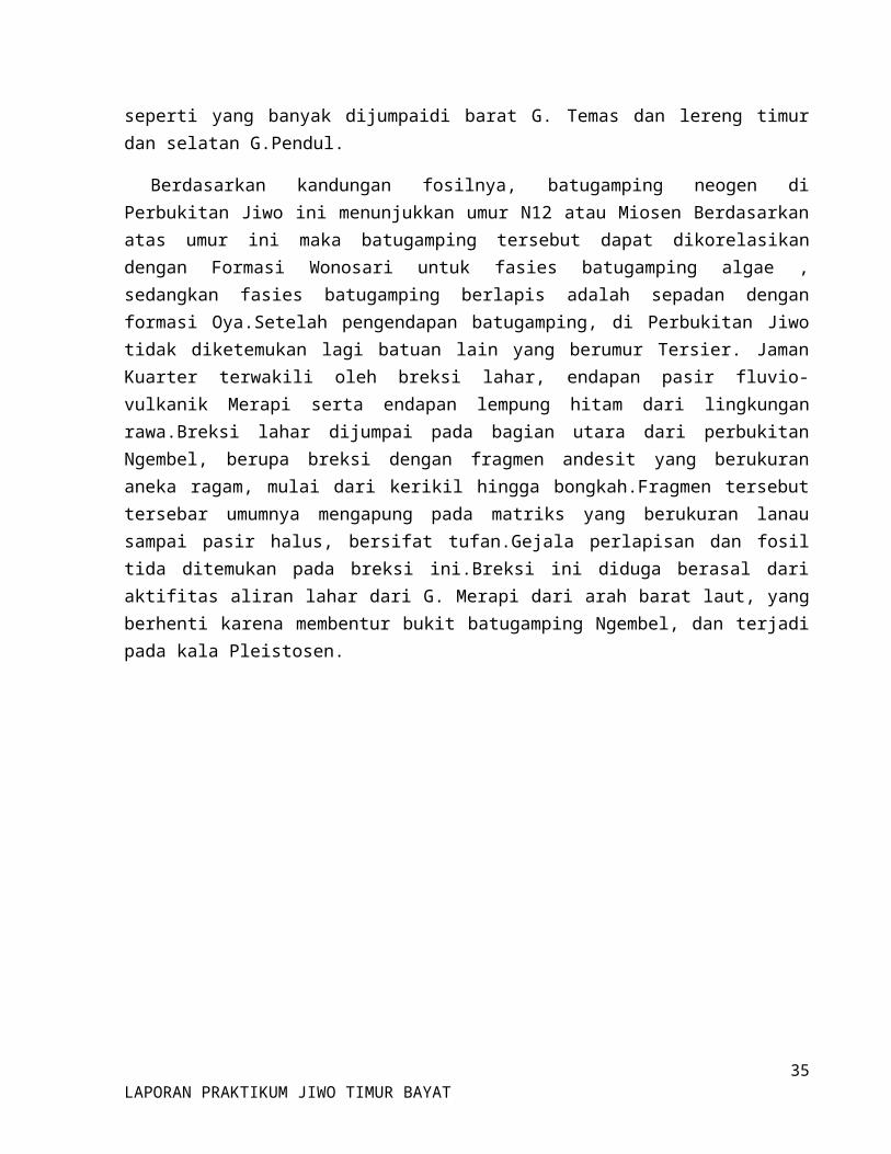
1. Lokasi : Gunung JetoPlotting : S 07° 45’ 16,8”
E 110° 40’ 08 ”
Hasil Pengukuran : - Strike / dip : N 21°E /8°- Slope : 30°- Arah Slope : N 205°E
Dijumpai singkapan Batu Gamping dengan ketebalan 16 meter.
Gambar 2.0 :singkapan gamping
25LAPORAN PRAKTIKUM JIWO TIMUR BAYAT
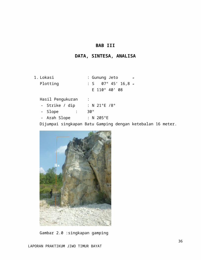
2. Lokasi : Gunung Joko TuaPlotting : S 07° 45’ 37,2”
E 110° 40° 29,6”
Hasil Pengukuran : - Liniasi (Batuan Metamorf skiss) : N 155°E- Batas antara Batuan Metamorf Gamping :
Koordinat : S 07° 45’ 41 ” E 110° 40’ 29,6”
Elevasi : 138 m
Gambar 2.1 : Singkapan batuan Joko Tuo
26LAPORAN PRAKTIKUM JIWO TIMUR BAYAT
- Kekar Joko Tua
1. N 95°E / N 140°E2. N 118°E / N 240°E3. N 216°E / N 248°E4. N 213°E / N 231°E5. N 200°E / N 260°E6. N 265°E / N 302°E7. N 19°E / N 322°E8. N 130°E / N 56°E9. N 300°E / N 255°E10. N 95°E / N 95°E11. N 140°E / N 80°E12. N 28°E / N 80°E13. N 19°E / N 74°E14. N 116°E / N 180°E15. N 32°E / N 85°E
16. N 19°E / N 320°E17. N 56°E / N 144°E18. N 74°E / N 178°E19. N 229°E / N 312°E20. N 95°E / N 140°E21. N 240°E / N 314°E22. N 10°E / N 88°E23. N 160°E / N 70°E24. N 65°E / N 18°E25. N 105°E / N 32°E26. N 23°E / N 250°E27. N 100°E / N 30°E28. N 235°E / N 300°E29. N 269°E / N 210°E30. N 259°E / N 198°E
- Terdapat Batuan Metamorf :1. Marmer2. Skiss3. Filit4. Gneiss
27LAPORAN PRAKTIKUM JIWO TIMUR BAYAT
3. Lokasi : Belakang Puskesmas BayatPlotting : S 07° 45’ 57,2“
E 110° 40’ 23,9”Hasil Pengukuran :- Strike / dip: N 55°E / 40°
N 43°E / 46° N 101°E / 38°
- Dijumpai :1. Intrusi Batuan Beku (Dionite membentuk Sill)2. Mylonite3. Grafit
- Dilokasi ini mayoritas sangat britle/mudah hancur karena diduga daerah ini merupakan daerah structur.
Gambar 2.2 :kenampakan singkapan di belakang Puskesmas
28LAPORAN PRAKTIKUM JIWO TIMUR BAYAT
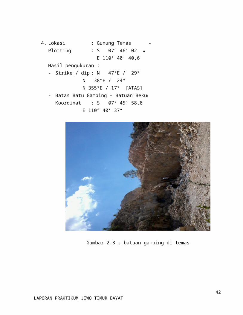
4. Lokasi : Gunung TemasPlotting : S 07° 46’ 02 ”
E 110° 40’ 40,6”Hasil pengukuran :- Strike / dip: N 47°E / 29°
N 38°E / 24° N 355°E / 17° [ATAS]
- Batas Batu Gamping – Batuan BekuKoordinat : S 07° 45’ 58,8”
E 110° 40’ 37“
Gambar 2.3 : batuan gamping di temas
29LAPORAN PRAKTIKUM JIWO TIMUR BAYAT

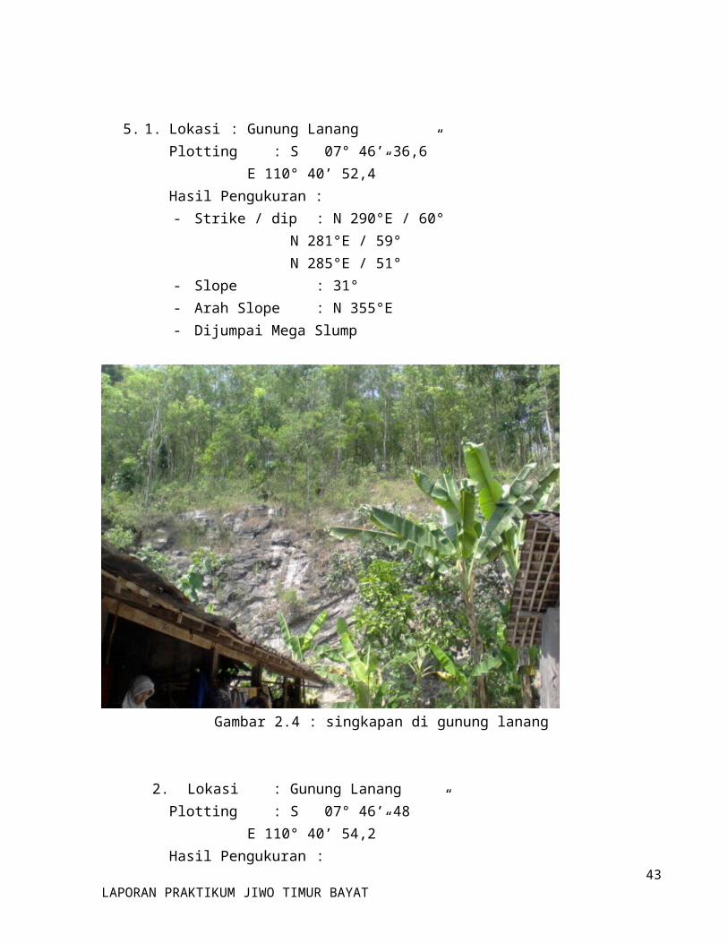
5. 1. Lokasi : Gunung LanangPlotting : S 07° 46’ 36,6”
E 110° 40’ 52,4”Hasil Pengukuran :- Strike / dip : N 290°E / 60°
N 281°E / 59° N 285°E / 51°
- Slope : 31°- Arah Slope : N 355°E- Dijumpai Mega Slump
Gambar 2.4 : singkapan di gunung lanang
2. Lokasi : Gunung LanangPlotting : S 07° 46’ 48 ”
E 110° 40’ 54,2”Hasil Pengukuran :- Strike / dip : N 20°E / 19°
N 25°E / 16°
30LAPORAN PRAKTIKUM JIWO TIMUR BAYAT
N 40°E / 21°
- Slope : 50°- Arah Slope : N 93°E- Dijumpai batuan gamping dan batu pasir dengan ketebalan 15,7 meter.
6. 1. Lokasi : Depan SMA BayatPlotting : S 07° 46’ 52,2”
E 110° 40’ 45,3”Hasil Pengukuran :- Strike / dip : N 190°E / 79°
N 350°E / 78° - Daftar Kekar SMA Bayat :
1. N 170°E / N 235°E2. N 75°E / N 165°E3. N 175°E / N 246°E4. N 210°E / N 140°E5. N 335°E / N 20°E6. N 200°E / N 260°E7. N 110°E / N 160°E8. N 175°E / N 240°E9. N 160°E / N 210°E10. N 165°E / N 250°E
11. N 145°E / N 185°E12. N 98°E / N 170°E13. N 220°E / N 300°E14. N 49°E / N 96°E15. N 74°E / N 149°E16. N 11°E / N 80°E17. N 5°E / N 94°E18. N 102°E / N 33°E19. N 343°E / N 287°E20. N 56°E / N 317°E
31LAPORAN PRAKTIKUM JIWO TIMUR BAYAT
2. Lokasi : Belakang SMA BayatPlotting : S 07° 46’ 57,8”
E 110° 40’ 49,4”
Gambar 2.5 : singkapan di belakang SMA Bayat
Hasil Pengukuran Kekar :1. N 295°E / N 42°E2. N 65°E / N 308°E3. N 310°E / N 245°E4. N 320°E / N 60°E5. N 340°E / N 300°E6. N 300°E / N 15°E7. N 235°E / N 334°E8. N 25°E / N 70°E9. N 320°E / N 40°E10. N 280°E / N 35°E11. N 235°E / N 334°E
12. N 60°E / N 345°E13. N 85°E / N 20°E14. N 315°E / N 60°E15. N 70°E / N 320°E16. N 320°E / N 70°E17. N 246°E / N 320°E18. N 296°E / N 214°E19. N 280°E / N 238°E20. N 240°E / N 335°E21. N 238°E / N 315°E22. N 255°E / N °325E
32LAPORAN PRAKTIKUM JIWO TIMUR BAYAT
7. Lokasi : Gunung MacanPlotting : S 07° 47’ 05,5”
E 110° 40’ 12,5”Kedudukan :
- N 129°E / 33°N 9°E / 29°N 310°E / 32°
- N 110°E / 40°N 98°E / 33°
- N 140°E / 21°N 160°E / 16°N 170°E / 34°
Intrusi : S 07° 47’ 7,1” E 170° 40’ 13,9”
Kekar :1. N 0°E / N 62°E2. N 179°E / N 128°E3. N 70°E / N 347°E4. N 55°E / N 355°E5. N 81°E / N 120°E6. N 98°E / N 123°E7. N 279°E / N 320°E8. N 250°E / N 144°E9. N 189°E / N 300°E10. N 357°E / N 50°E
11. N 130°E / N 156°E12. N 55°E / N 100°E13. N 215°E / N 245°E14. N 317°E / N 272°E15. N 341°E / N 289°E
16. N 5°E / N 300°E17. N 280°E / N 212°E18. N 356°E / N 287°E19. N 334°E / N 290°E20. N 147°E / N 100°E
33LAPORAN PRAKTIKUM JIWO TIMUR BAYAT
8. Lokasi : Watu PrauPlotting : S 07° 46’ 0,08”
E 110° 40’ 14,5 ”Terdapat Gamping Numulites, Lempung, Pasir,Intrusi Skiss dan Serpihan Kuarsit.
Kedudukan Batu PasirN 50°E / 34°N 67°E / 28°N 60°E / 29°
Gambar 2.6 : singkapan gamping numuliteBatasNumulites – Skiss
1. S 07° 46’ 10 ”E 110° 39’ 59,1”
2. S 07° 45’ 59,8”E 110° 40’ 15 “
3. S 07° 46’ 39,1”E 110° 40’ 14,1”
4. S 07° 46’ 59,1”E 110° 40’ 14,2”
5. S 07° 46’ 00,9”34
LAPORAN PRAKTIKUM JIWO TIMUR BAYAT
E 110° 40’ 00 “9. Lokasi : Sumber Rejo (Belakang Rumah)
Plotting : S 07° 46‘ 35,9 “ E 110° 40‘ 23,2“
Hasil Pengukuran- Strike / dip : N 65°E / 35°
N 55°E / 40° N 70°E / 21° N 309°E / 18° N 304°E / 19°
- Kekar :1. N 322°E / N 255°E2. N 347°E / N 289°E3. N 300°E / N 11°E4. N 324°E / N 224°E5. N 262°E / N 161°E6. N 160°E / N 194°E7. N 112°E / N 175°E8. N 26°E / N 312°E9. N 84°E / N 158°E10. N 282°E / N 8°E
11. N 188°E / N 133°E12. N 130°E / N 176°E13. N 146°E / N 123°E14. N 133°E / N 181°E15. N 145°E / N 216°E16. N 30°E / N 80°E17. N 350°E / N 275°E18. N 11°E / N 90°E19. N 118°E / N 180°E20. N 130°E / N 176°E
10. Lokasi : JerukanPlotting : S 07° 46’ 34,6”
E 110° 40’ 5,8”Data :
- Strike / dip : N 35°E / 42° N 37°E / 43°
- Batas Sedimen-Beku : S 07° 46’ 35,1” E 110° 40’ 5,8”
- Dijumpai Intrusi Batuan Beku dan Lanau
35LAPORAN PRAKTIKUM JIWO TIMUR BAYAT
11. Lokasi : Gunung PendulPlotting : S 07° 46’ 18,2”
E 110° 40’ 20,5”Hasil Pengukuran :
- Strike / dip : N 47°E / 15° N 50°E / 35°
- Slope : N 178°E- Arah Slope : 15°- Dijumpai Intrusi Batuan Beku, Mylonite- Dijumpai Batuan Metamorf & liniasi N 35°E- Batas Lanau & Filit : S 07° 46’ 18,2”
E 110° 40’ 20,4”- Metamorf N 63°E- Urat kalsit ± 5mm- Koordinat Batas
1. S 07° 46‘ 20,6“E 110° 40‘ 15,6“
2. S 07° 46‘ 21,0“E 110° 40‘ 16,0“
3. S 07° 46‘ 19,4“E 110° 40‘ 19,4“
4. S 07° 46‘ 19,2“E 110° 40‘ 21,6“
5. S 07° 46‘ 20,2“E 110° 40‘ 22,1“
36LAPORAN PRAKTIKUM JIWO TIMUR BAYAT
Gambar 2.7 : singkapan lanau di Pendhul- Kekar :
1. N 355°E / N 305°E2. N 98°E / N 170°E3. N 245°E / N 315°E4. N 203°E / N 149°E5. N 122°E / N 192°E6. N 190°E / N 266°E7. N 90°E / N 24°E8. N 65°E / N 135°E9. N 185°E / N 165°E10. N 116°E / N 197°E11. N 183°E / N 249°E12. N 126°E / N 58°E13. N 270°E / N 192°E14. N 122°E / N 192°E15. N 90°E / N 122°E16. N 65°E / N 135°E17. N 162°E / N 236°E18. N 106°E / N 30°E19. N 125°E / N 20°E20. N 110°E / N 200°E
37LAPORAN PRAKTIKUM JIWO TIMUR BAYAT
DESKRIPSI BATUAN PER STASIUN
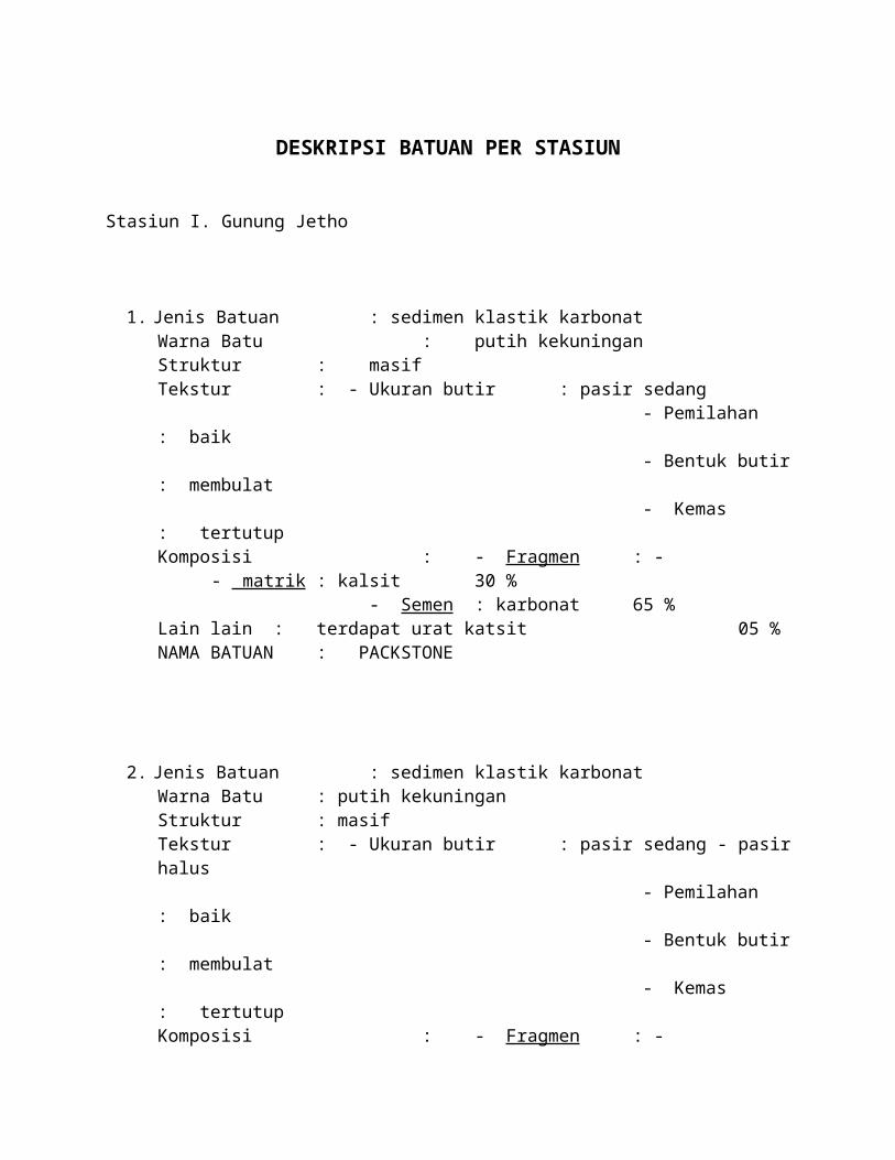
Stasiun I. Gunung Jetho
1. Jenis Batuan : sedimen klastik karbonatWarna Batu : putih kekuninganStruktur : masifTekstur : - Ukuran butir : pasir sedang - Pemilahan : baik - Bentuk butir : membulat - Kemas : tertutupKomposisi : - Fragmen : -
- matrik : kalsit 30 %- Semen : karbonat 65 %
Lain lain : terdapat urat katsit 05 %NAMA BATUAN : PACKSTONE
2. Jenis Batuan : sedimen klastik karbonatWarna Batu : putih kekuninganStruktur : masifTekstur : - Ukuran butir : pasir sedang - pasir halus - Pemilahan : baik - Bentuk butir : membulat - Kemas : tertutupKomposisi : - Fragmen : -
- matrik : kalsit 25 %- Semen : karbonat 75%
Lain lain :NAMA BATUAN : WACKSTONE
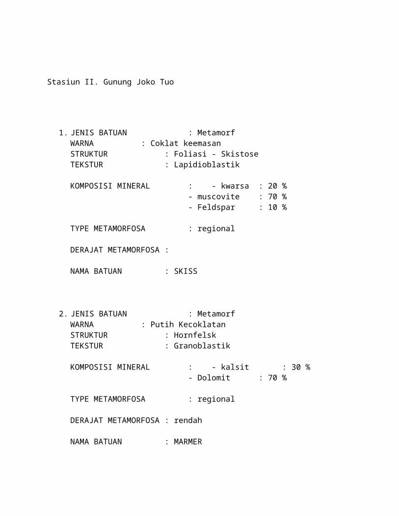
Stasiun II. Gunung Joko Tuo
1. JENIS BATUAN : MetamorfWARNA : Coklat keemasanSTRUKTUR : Foliasi - Skistose TEKSTUR : Lapidioblastik
KOMPOSISI MINERAL : - kwarsa : 20 %- muscovite : 70 %- Feldspar : 10 %
TYPE METAMORFOSA : regional
DERAJAT METAMORFOSA :
NAMA BATUAN : SKISS
2. JENIS BATUAN : MetamorfWARNA : Putih KecoklatanSTRUKTUR : HornfelskTEKSTUR : Granoblastik
KOMPOSISI MINERAL : - kalsit : 30 %- Dolomit : 70 %
TYPE METAMORFOSA : regional
DERAJAT METAMORFOSA : rendah
NAMA BATUAN : MARMER

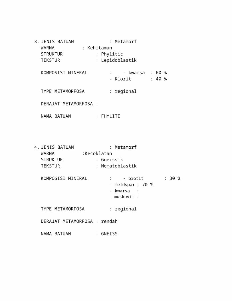
3. JENIS BATUAN : MetamorfWARNA : KehitamanSTRUKTUR : PhyliticTEKSTUR : Lepidoblastik
KOMPOSISI MINERAL : - kwarsa : 60 %- Klorit : 40 %
TYPE METAMORFOSA : regional
DERAJAT METAMORFOSA :
NAMA BATUAN : FHYLITE
4. JENIS BATUAN : MetamorfWARNA :KecoklatanSTRUKTUR : GneissikTEKSTUR : Nematoblastik
KOMPOSISI MINERAL : - biotit : 30 %- feldspar : 70 %- kwarsa : - muskovit :
TYPE METAMORFOSA : regional
DERAJAT METAMORFOSA : rendah
NAMA BATUAN : GNEISS

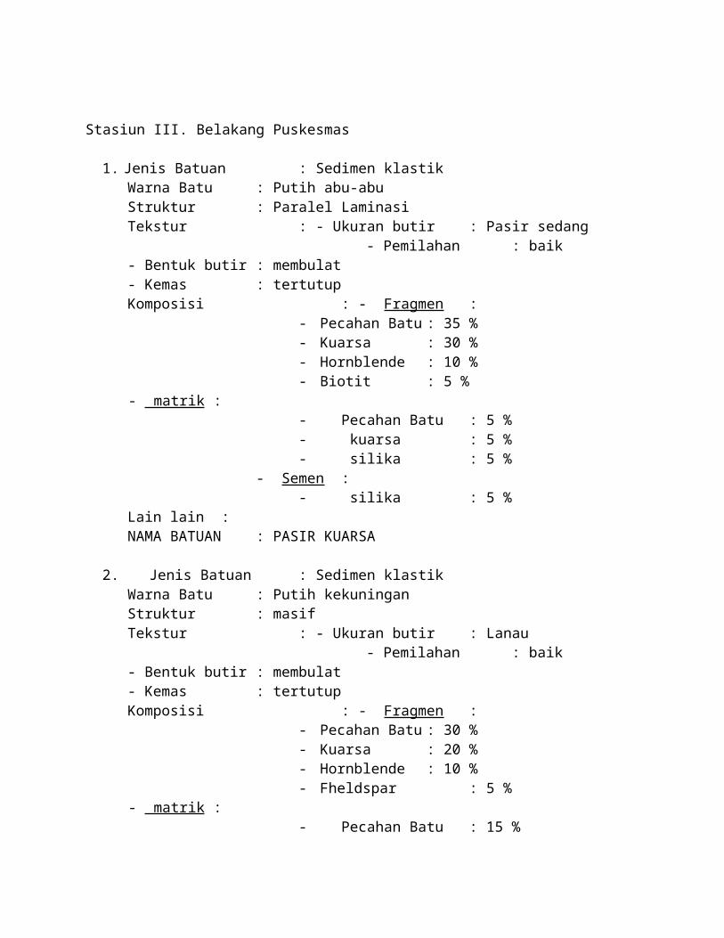
Stasiun III. Belakang Puskesmas
1. Jenis Batuan : Sedimen klastikWarna Batu : Putih abu-abuStruktur : Paralel LaminasiTekstur : - Ukuran butir : Pasir sedang - Pemilahan : baik- Bentuk butir : membulat- Kemas : tertutupKomposisi : - Fragmen :
- Pecahan Batu : 35 %- Kuarsa : 30 %- Hornblende : 10 %- Biotit : 5 %
- matrik :- Pecahan Batu : 5 %- kuarsa : 5 %- silika : 5 %
- Semen :- silika : 5 %
Lain lain : NAMA BATUAN : PASIR KUARSA
2. Jenis Batuan : Sedimen klastikWarna Batu : Putih kekuninganStruktur : masifTekstur : - Ukuran butir : Lanau - Pemilahan : baik- Bentuk butir : membulat- Kemas : tertutupKomposisi : - Fragmen :
- Pecahan Batu : 30 %- Kuarsa : 20 %- Hornblende : 10 %- Fheldspar : 5 %
- matrik :- Pecahan Batu : 15 %- kuarsa : 25 %
Lain lain : NAMA BATUAN : LANAU
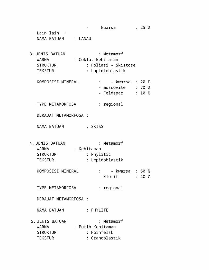
3. JENIS BATUAN : MetamorfWARNA : Coklat kehitamanSTRUKTUR : Foliasi - Skistose TEKSTUR : Lapidioblastik
KOMPOSISI MINERAL : - kwarsa : 20 %- muscovite : 70 %- Feldspar : 10 %
TYPE METAMORFOSA : regional
DERAJAT METAMORFOSA :
NAMA BATUAN : SKISS
4. JENIS BATUAN : MetamorfWARNA : KehitamanSTRUKTUR : PhyliticTEKSTUR : Lepidoblastik
KOMPOSISI MINERAL : - kwarsa : 60 %- Klorit : 40 %
TYPE METAMORFOSA : regional
DERAJAT METAMORFOSA :
NAMA BATUAN : FHYLITE
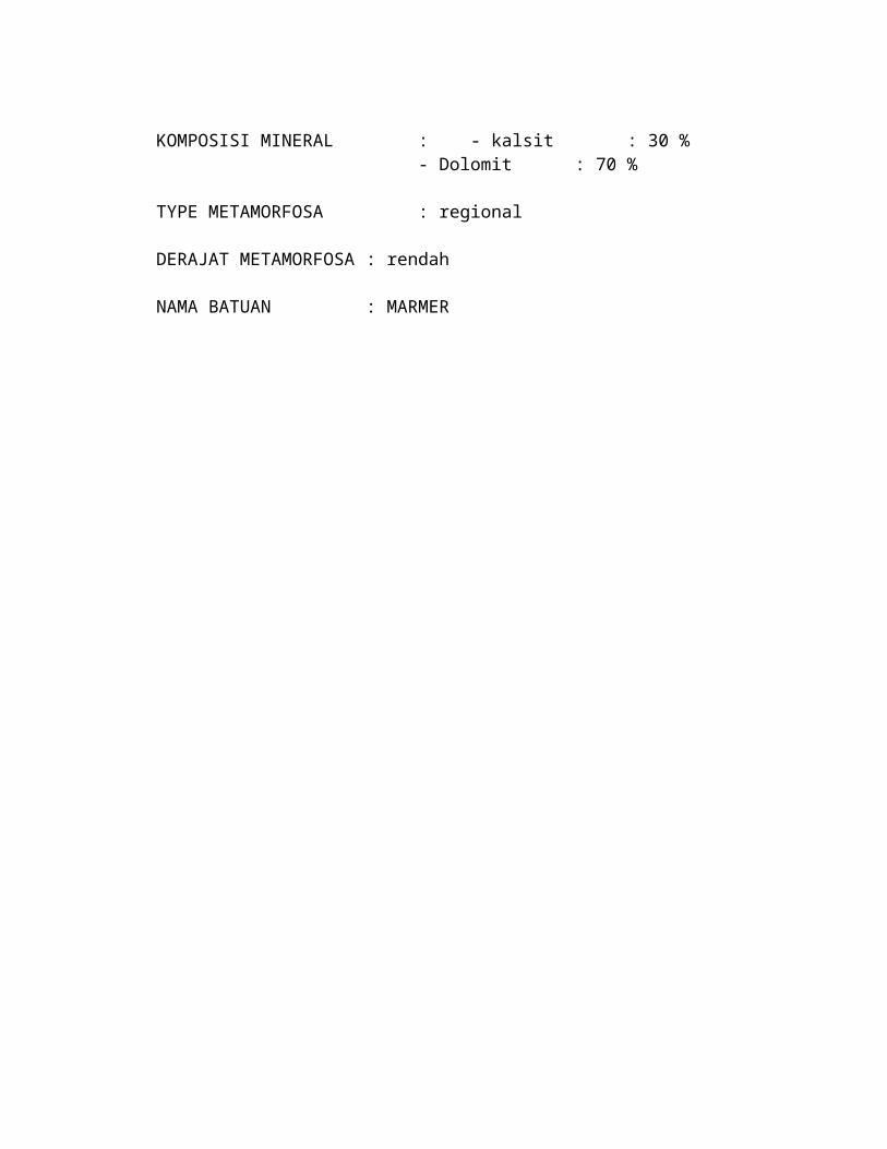
5. JENIS BATUAN : MetamorfWARNA : Putih KehitamanSTRUKTUR : HornfelskTEKSTUR : Granoblastik
KOMPOSISI MINERAL : - kalsit : 30 %- Dolomit : 70 %
TYPE METAMORFOSA : regional
DERAJAT METAMORFOSA : rendah
NAMA BATUAN : MARMER
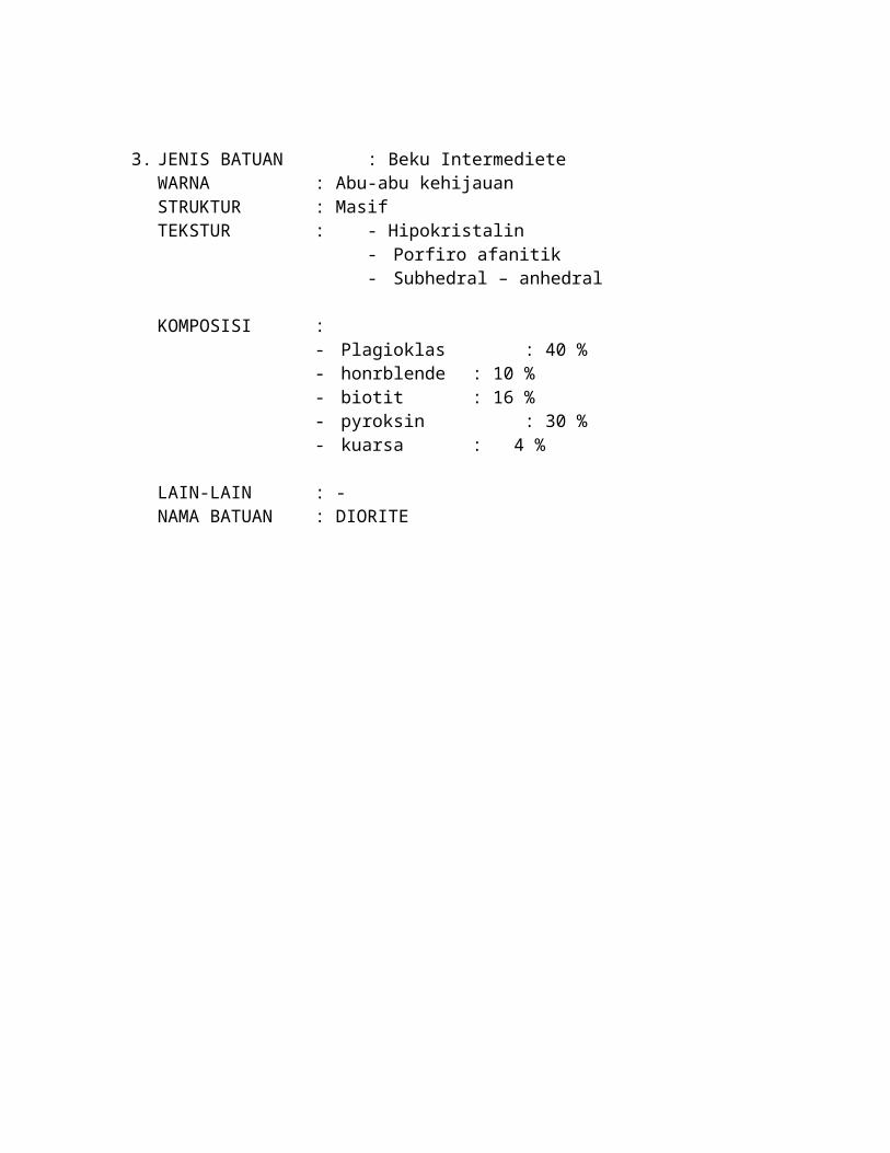
6. JENIS BATUAN : Beku IntermedieteWARNA : Abu-abu kehijauanSTRUKTUR : MasifTEKSTUR : - Hipokristalin
- Porfiro afanitik- Subhedral – anhedral
KOMPOSISI :- Plagioklas : 40 %- honrblende : 10 %- biotit : 16 %- pyroksin : 30 %- kuarsa : 4 %
LAIN-LAIN : -NAMA BATUAN : DIORITE
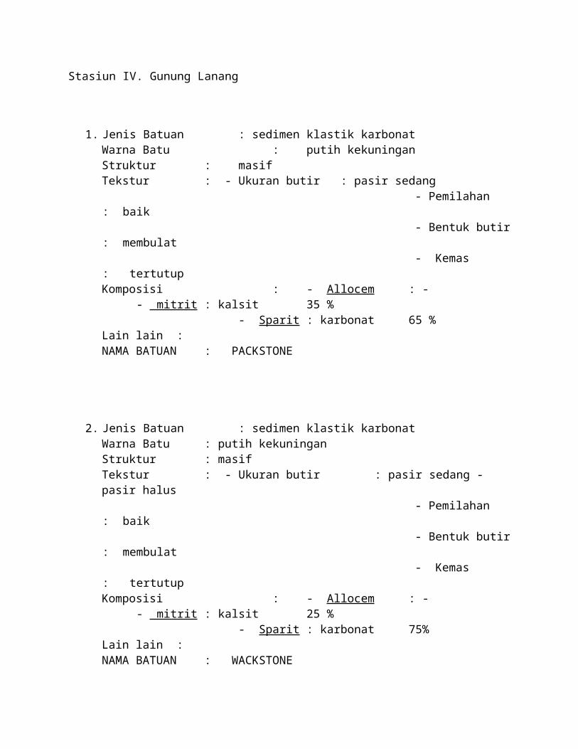
Stasiun IV. Gunung Lanang
1. Jenis Batuan : sedimen klastik karbonatWarna Batu : putih kekuninganStruktur : masifTekstur : - Ukuran butir : pasir sedang - Pemilahan : baik - Bentuk butir : membulat - Kemas : tertutupKomposisi : - Allocem : -
- mitrit : kalsit 35 %- Sparit : karbonat 65 %
Lain lain : NAMA BATUAN : PACKSTONE
2. Jenis Batuan : sedimen klastik karbonatWarna Batu : putih kekuninganStruktur : masifTekstur : - Ukuran butir : pasir sedang - pasir halus - Pemilahan : baik - Bentuk butir : membulat - Kemas : tertutupKomposisi : - Allocem : -
- mitrit : kalsit 25 %- Sparit : karbonat 75%
Lain lain :NAMA BATUAN : WACKSTONE
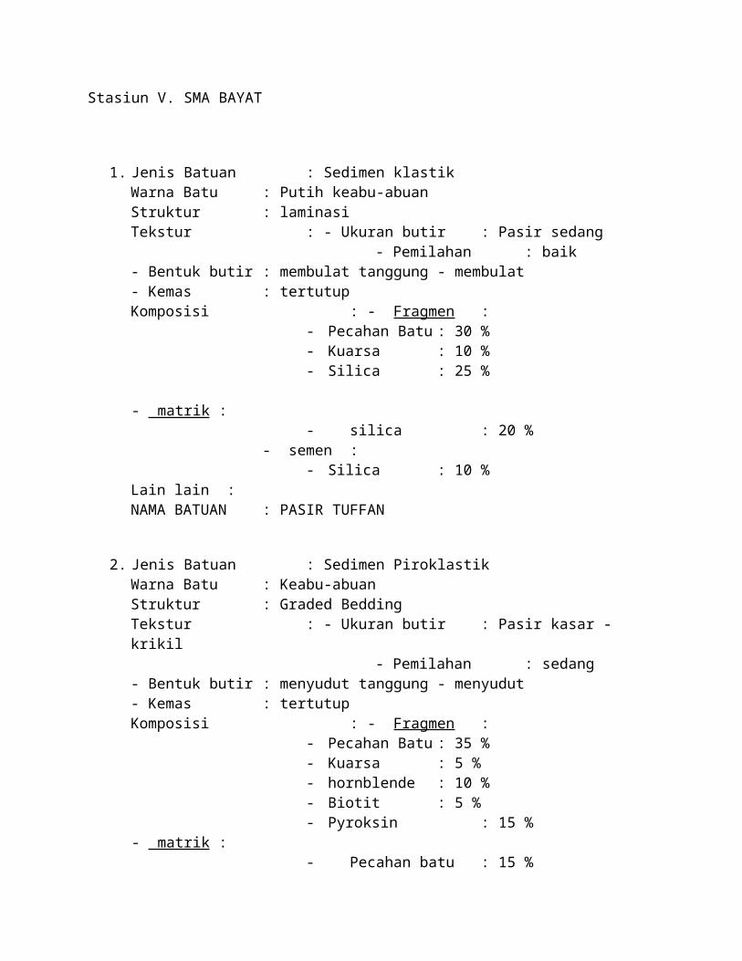
Stasiun V. SMA BAYAT
1. Jenis Batuan : Sedimen klastikWarna Batu : Putih keabu-abuanStruktur : laminasiTekstur : - Ukuran butir : Pasir sedang - Pemilahan : baik- Bentuk butir : membulat tanggung - membulat- Kemas : tertutupKomposisi : - Fragmen :
- Pecahan Batu : 30 %- Kuarsa : 10 %- Silica : 25 %
- matrik :- silica : 20 %
- semen :- Silica : 10 %
Lain lain : NAMA BATUAN : PASIR TUFFAN
2. Jenis Batuan : Sedimen PiroklastikWarna Batu : Keabu-abuanStruktur : Graded BeddingTekstur : - Ukuran butir : Pasir kasar - krikil - Pemilahan : sedang- Bentuk butir : menyudut tanggung - menyudut- Kemas : tertutupKomposisi : - Fragmen :
- Pecahan Batu : 35 %- Kuarsa : 5 %- hornblende : 10 %- Biotit : 5 %- Pyroksin : 15 %
- matrik :- Pecahan batu : 15 %- Kuarsa : 5 %
- semen :- Silica : 10 %
Lain lain : NAMA BATUAN : BREKSI TUFFAN
Stasiun VI. Gunung Macan
1. Jenis Batuan : Sedimen klastikWarna Batu : Putih keabu-abuanStruktur : laminasiTekstur : - Ukuran butir : Pasir sedang - Pemilahan : baik- Bentuk butir : membulat tanggung - membulat- Kemas : tertutupKomposisi : - Fragmen :
- Pecahan Batu : 30 %- Kuarsa : 10 %- Silica : 25 %
- matrik :- pecahan batu : 20 %- Silica : 5 %
- semen :- Silica : 10 %
Lain lain : NAMA BATUAN : PASIR TUFFAN
2. Jenis Batuan : Sedimen klastikWarna Batu : Putih kekuninganStruktur : masifTekstur : - Ukuran butir : Lanau - Pemilahan : baik- Bentuk butir : membulat- Kemas : tertutupKomposisi : - Fragmen :
- Pecahan Batu : 30 %- Kuarsa : 20 %- Hornblende : 10 %- Fheldspar : 5 %
- matrik :- muscovite : 15 %- kuarsa : 25 %
Lain lain : NAMA BATUAN : LANAU
3. JENIS BATUAN : Beku IntermedieteWARNA : Abu-abu kehijauanSTRUKTUR : MasifTEKSTUR : - Hipokristalin
- Porfiro afanitik- Subhedral – anhedral
KOMPOSISI :- Plagioklas : 40 %- honrblende : 10 %- biotit : 16 %- pyroksin : 30 %- kuarsa : 4 %
LAIN-LAIN : -NAMA BATUAN : DIORITE
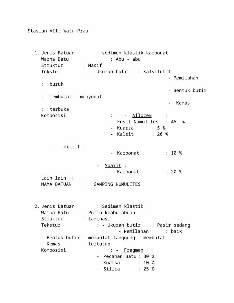
Stasiun VII. Watu Prau
1. Jenis Batuan : sedimen klastik karbonatWarna Batu : Abu - abuStruktur : MasifTekstur : - Ukuran butir : Kalsilutit - Pemilahan : buruk - Bentuk butir : membulat - menyudut - Kemas : terbukaKomposisi : - Allocem :
- Fosil Numulites : 45 %- Kuarsa : 5 %- Kalsit : 20 %
- mitrit :- Karbonat : 10 %
- Sparit :- Karbonat : 20 %
Lain lain : NAMA BATUAN : GAMPING NUMULITES
2. Jenis Batuan : Sedimen klastikWarna Batu : Putih keabu-abuanStruktur : laminasiTekstur : - Ukuran butir : Pasir sedang - Pemilahan : baik- Bentuk butir : membulat tanggung - membulat- Kemas : tertutupKomposisi : - Fragmen :
- Pecahan Batu : 30 %- Kuarsa : 10 %- Silica : 25 %
- matrik :- pecahan batu : 20 %- Silica : 5 %
- semen :- Silica : 10 %
NAMA BATUAN : BATU PASIR
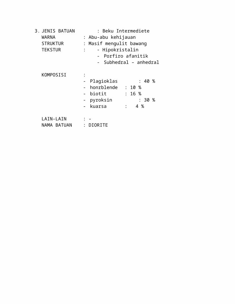
3. JENIS BATUAN : Beku IntermedieteWARNA : Abu-abu kehijauanSTRUKTUR : Masif mengulit bawangTEKSTUR : - Hipokristalin
- Porfiro afanitik- Subhedral – anhedral
KOMPOSISI :- Plagioklas : 40 %- honrblende : 10 %- biotit : 16 %- pyroksin : 30 %- kuarsa : 4 %
LAIN-LAIN : -NAMA BATUAN : DIORITE
Stasiun VII. Gunung Pendhul
1. JENIS BATUAN : Beku IntermedieteWARNA : Abu-abu kehijauanSTRUKTUR : Masif (mengulit bawang)TEKSTUR : - Hipokristalin
- Porfiro afanitik- Subhedral – anhedral
KOMPOSISI :- Plagioklas : 40 %- honrblende : 15 %- biotit : 11 %- pyroksin : 30 %- kuarsa : 4 %
LAIN-LAIN : -NAMA BATUAN : DIORITE
2. Jenis Batuan : Sedimen klastikWarna Batu : Putih keabu-abuanStruktur : laminasiTekstur : - Ukuran butir : Pasir sedang - Pemilahan : baik- Bentuk butir : membulat tanggung - membulat- Kemas : tertutupKomposisi : - Fragmen :
- Pecahan Batu : 30 %- Kuarsa : 10 %- Silica : 20 %- Hornblende : 5 %
- matrik :- pecahan batu : 20 %- Silica : 5 %
- semen :- Silica : 10 %
NAMA BATUAN : BATU PASIR
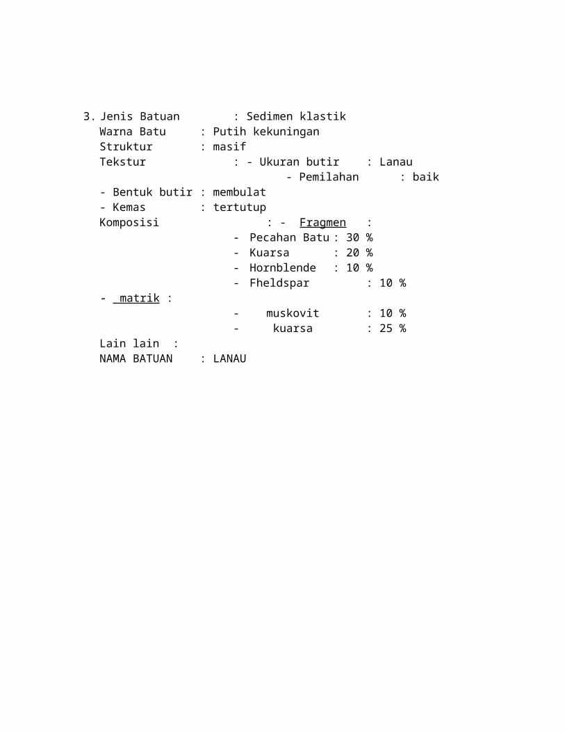
3. Jenis Batuan : Sedimen klastikWarna Batu : Putih kekuninganStruktur : masifTekstur : - Ukuran butir : Lanau - Pemilahan : baik- Bentuk butir : membulat- Kemas : tertutupKomposisi : - Fragmen :
- Pecahan Batu : 30 %- Kuarsa : 20 %- Hornblende : 10 %- Fheldspar : 10 %
- matrik :- muskovit : 10 %- kuarsa : 25 %
Lain lain : NAMA BATUAN : LANAU
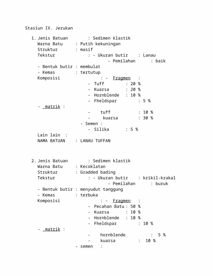
Stasiun IX. Jerukan
1. Jenis Batuan : Sedimen klastikWarna Batu : Putih kekuninganStruktur : masifTekstur : - Ukuran butir : Lanau - Pemilahan : baik- Bentuk butir : membulat- Kemas : tertutupKomposisi : - Fragmen :
- Tuff : 20 %- Kuarsa : 20 %- Hornblende : 10 %- Fheldspar : 5 %
- matrik :- tuff : 10 %- kuarsa : 30 %
- Semen :- Silika : 5 %
Lain lain : NAMA BATUAN : LANAU TUFFAN
2. Jenis Batuan : Sedimen klastikWarna Batu : KecoklatanStruktur : Gradded bading Tekstur : - Ukuran butir : krikil-krakal - Pemilahan : buruk- Bentuk butir : menyudut tanggung- Kemas : terbukaKomposisi : - Fragmen :
- Pecahan Batu : 50 %- Kuarsa : 10 %- Hornblende : 10 %- Fheldspar : 10 %
- matrik :- hornblende : 5 %- kuarsa : 10 %
- semen :- Silika : 5 %
Lain lain : NAMA BATUAN : BREKSI ALAS
ANALISA
TABEL DIAGRAM KIPAS
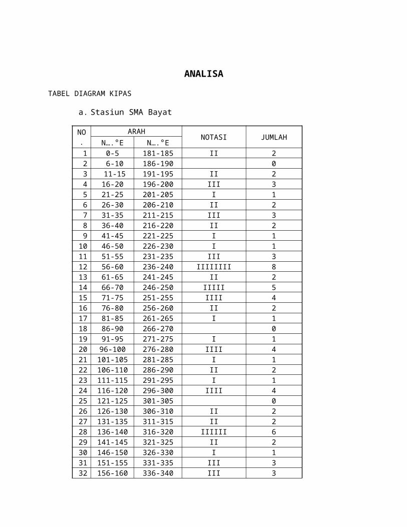
a. Stasiun SMA Bayat
NO.ARAH
NOTASI JUMLAHN….°E N….°E
1 0-5 181-185 II 22 6-10 186-190 03 11-15 191-195 II 24 16-20 196-200 III 35 21-25 201-205 I 16 26-30 206-210 II 27 31-35 211-215 III 38 36-40 216-220 II 29 41-45 221-225 I 1
10 46-50 226-230 I 111 51-55 231-235 III 312 56-60 236-240 IIIIIIII 813 61-65 241-245 II 214 66-70 246-250 IIIII 515 71-75 251-255 IIII 416 76-80 256-260 II 217 81-85 261-265 I 118 86-90 266-270 019 91-95 271-275 I 120 96-100 276-280 IIII 421 101-105 281-285 I 122 106-110 286-290 II 223 111-115 291-295 I 124 116-120 296-300 IIII 425 121-125 301-305 026 126-130 306-310 II 227 131-135 311-315 II 228 136-140 316-320 IIIIII 629 141-145 321-325 II 230 146-150 326-330 I 131 151-155 331-335 III 332 156-160 336-340 III 333 161-165 341-345 IIII 434 166-170 346-350 III 335 171-175 351-355 II 236 176-180 356-360 0
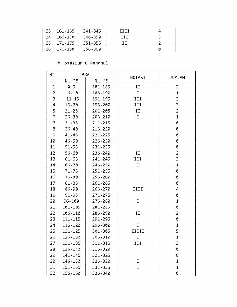
b. Stasiun G.Pendhul
NO.ARAH
NOTASI JUMLAHN….°E N….°E
1 0-5 181-185 II 22 6-10 186-190 I 13 11-15 191-195 III 34 16-20 196-200 III 35 21-25 201-205 II 26 26-30 206-210 I 17 31-35 211-215 08 36-40 216-220 09 41-45 221-225 0
10 46-50 226-230 011 51-55 231-235 012 56-60 236-240 II 213 61-65 241-245 III 314 66-70 246-250 I 115 71-75 251-255 016 76-80 256-260 017 81-85 261-265 018 86-90 266-270 IIII 419 91-95 271-275 020 96-100 276-280 I 121 101-105 281-285 022 106-110 286-290 II 223 111-115 291-295 024 116-120 296-300 I 125 121-125 301-305 IIIII 526 126-130 306-310 I 127 131-135 311-315 III 328 136-140 316-320 029 141-145 321-325 030 146-150 326-330 I 131 151-155 331-335 I 132 156-160 336-340 033 161-165 341-345 II 234 166-170 346-350 I 135 171-175 351-355 036 176-180 356-360 0

Gambar diagram kipas G. Pendhul
Gambar diagram kipas G. SMA BAYAT
PENUTUP
A. Kesimpulan
Perbukitan jiwo timur terdapat 3 jenis batuan yaitu; batuan beku (intrusi), batuan sedimen dan batuan metamorf. Batuan beku menerobos batuan lainnya (sill, dike) terutama batuan sedimen. Dengan begitu batuan beku menjadi batuan termuda setelah alluvial, kemudian disusul batuan sedimen yaitu batu gamping numulites, batu pasir dan batu lanau. Kemudian ditemukan batuan breksi alas, menjadikan batuantersebut menjadi batuan tertua sebelim batuan metamorf.
Dari data yang kita dapat kemungkinan besar daerah Jiwo Timur banyak terdapat structure geologi (sesar, lipatan, patahan,dll) karena ditemukan tanda-tanda adanya zona hancuran(milonitik), adanya intrusi yang menunjukan adanya zona lemah dan dijumpai batuan yang kompleks dalam suatu lokasi yang terbilang tidak luas.
Perlu adanya penelitian lebih lanjut supaya pemetaan geologi atau pengungkapan sejarah daerah Jiwo timur, bayat bisa memperoleh hasil yang maksimal.
B. Kendala selama kegiatan
Untuk kendala yang besar, alhamdulilah kami tidak mengalaminya. Hanya kendala kecil saja yang kami dapatkan selama kegiatan ini, diantaranya :
a. Ban sepeda motor bocorb. Terlalu banyak bercandac. Kehilangan pengarisd. Gps kehabisan battrey
C. Kritik dan SaranKami memiliki beberapa kritik sebagai berikut:
a. Seharusnya bapak/ibu guru mengawasi langsung para siswa ketika praktikum di lapangan
b. Untuk teman-teman ketika praktikum jangan banyak bercandac. Peta lapangan sebaiknya dikasih lebih banyak untuk cadangand. Tempat mandi kurang banyake. Untuk teman-teman ketika berkendara jangan ugal-ugalan
Kami memiliki beberapa saran sebagai berikut:

a. Sebelum ke lapangan sebaiknya siswa dibekali ilmu secara matang supaya ketika praktikum dapat maksimal
b. Perlu adanya penelitian lebih lanjut supaya pemetaan geologi atau pengungkapan sejarah daerah Jiwo timur, bayat bisa memperoleh hasil yang maksimal.
DAFTAR PUSTAKA
Holidi. Diktat Pemetaan Geologi. Tidak diterbitkan. Yogyakarta: SMK Negeri 2 Depok Sleman.
EAST REGIONAL GEOLOGY hills JiwoBayat DISTRICT, DISTRICT KLATEN
CENTRAL JAVA PROVINCE
Map of Indonesia RBI Cawas Map Sheet Map No. 140 ....
GEOLOGICAL MAPPING THE SELF 2012
Prepared by:
AGUSTINA PUTRI P. (XII GPA/12966)
CATUR GUNAWAN (XII GPA/12982)
CYRILUS ARYO YUNANTO (XII GPA/12983)
FAJAR ANANG PRASETYA (XII GPA/12991)
RIZKY DARMAWAN (XII GPB/13016)
YANUARDHI SATRIA N. (XII GPB/13023)
PROGRAM KEAHLIAN GEOLOGI PERTAMBANGAN
SMK NEGERI 2 DEPOK SLEMAN YOGYAKARTA
2012
CERTIFICATION SHEET
In order to fulfill graduation requirements proposed Eyes Mapping Programs to Increase Class XIII and administered by the Program of Mining Geology SMK Negeri 2 Depok Sleman
Yogyakarta, June 5, 2012
Constituent classes / NIS Signature
XII GP 1.XII GP 2.XII GP 3.XII GP 4.XII GP 5.XII GP 6.
Approve,
KPK Mining Geology
Drs. Agung Widyatmoko, M. Pd.NIP. 19611006 198803 1004
Supervising Teachers
HeriNIP.
ABSTRACT
Bayat is a district in Klaten, Central Java. This district is bordered by South Mountain District, Yogyakarta Special Region in the south. Bayat has an area of 39.43 ± km2dengan population of 56 040 inhabitants.In Physiographic Hills Bayat is an inlier of Tertiary and Tertiary rocks Pre around the Quaternary deposits, which mainly consists of volcanic deposits from Merapi.Elevasi flufio-highest of the peaks are no more than 400 meters above sea level, so the hills can be rendah.Perbukitan hills called the spread according to a direction different pathways.In the western part (West Jiwo), line the hilltops north-south trending, which is represented by peaks Jabalkat, Kebo, Merak, scratches, Budo Sari, and the monument to the northern most part turned to the west, the hills yaitudaerah ax. On the east (East Jiwo) direction is east-west track, with peaks Konang, pendul and Temas, with branching towards the north, which are represented by peaks and Bawak Jokotuo.
Stratigraphic sequences ranging from Pre Tertiary age Metamorfi unit to Middle Miocene units exposed properly. In the hills Jiwo, on the Morphology Unit Pre-Tertiary age situated not aligned units shallow marine limestones and sandstones of the Middle Eocene, Wungkal Formation, and Formation Dalkeith. Is not aligned on the Formation of Dalkeith lies units turbidit marine sediments in the Late Oligocene to Miocene age Early (N.2 zone - N8), namely the formation of Kebo, Butak Formation, Formation breeze, and the Formation Nglanggran, where units are located at zone of the Southern Mountains of East Java. All of these units, are not aligned limestone unit is covered by the old Central Mosen (zone N-12), namely Oyo Formation. The research also happening in diorite and diabase pengintrusian estimated to occur in early and Middle Miocene diorite intrusion is estimated to occur in Pliocene time.
Geological structures that develop in the area of research is the structure of fold and fault-fault up, down, and a horizontal fault. Geological structure is expected to grow due to the operation of the compression force is almost north-south trending is likely to take place in two periods, in the early Middle Miocene time before Oyo Formation was deposited and the Pliocene time after the Oyo Formation was deposited. Minerals yangterdapat in research areas that have economic value are marble, limestone, clay, breccia tufaa and igneous rocks.

LIST OF CONTENTS
Page Title
Ratification of the page
Foreword
Pollen
List of contents
List of Figures
Chapter I Introduction
Background
Purpose and Objectives
Regional location and accomplished
Work equipment
Basic Theory
Chapter II Geology Regional
General conditions of Bayat district
Regional geomorphology
Regional Geological Structure
Chapter III Data, Synthesis, Analysis
List of Figures
CHAPTER I
INTRODUCTION
A. Background
The earth's surface is one part that should be studied in the mastery of the science of
geology as topographic expression can indicate the state of geological structure and
litologinya. Thus, geomorphology is very involved in studying the geological
structure.Morphological formations we encounter today is the result of forces acting both
from within and from outside the earth. These formations will vary depending on the
shape of the system that influence it. For example, the development of the tectonic
system in a region will contribute to the development of geological structures that are
directly or indirectly be illustrated on the surface.
On the other hand lithology also play a role in expressing the topography. Value and the
least resistant lithology will provide different relief on the surface. Lithology is hard
(resistant) tend to form more prominent relief (higher) than the lithology of the area with
softer (less resistant). For example, the area prepared by the limestone lithology
(resistant) to form a landscape pattern of "karst topography" as a very typical pattern
(alone). Shape that is different from the position of lithology and morphology resulting in
the formation lithology distribution pattern is called pattern on the surface or outcrop.
In reading and understanding the basics of understanding the geological map required
elements supporting the geological map.
B. Purpose and objectives
a. Understand the definition of a geological map and its elements.
b. Understanding the pattern of outcrop, thickness, depth and geological cross-section
manufacture
c. Read and understand the basics of making a geological map.
C. Regional location and accomplished
Location of the practice field in the eastern Jiwo hills, Bayat, Klaten, Central Java.
Students use vehicles to reach the location. The distance between the location of the
practice development stm range of approximately 80km. This distance can be achieved

with a half hour with an average speed of 70 km / h. Activities undertaken during the
five-day practice. Students make homes as a base camp for five days. During the
practice students also use a motor vehicle (if the terrain allows) to shorten the travel
time.
D. Work equipment
1.Tennis shoes
2. Battle dress
3. Geological hammer
4. Geological compass
5. Hardboard
6. Stationery
7. Markers
8. Sample bags
9. Arc, a ruler
10. Topographic maps
11. Motor vehicle
12. Geological hammer
13. GPS (global positioning system)
14. Communication tools
15. Calculator
16. Meteran
E. BASIC THEORY
DEFINITION
a. Mapping
Mapping is the process of measurement, calculation and depiction of the earth's surface
(geodetic terminology) using the means or method that results obtained in the form of
soft and shaped hardcopypeta vector and raster.
b. Geological map
Geological map is a form of geological information of a region / area / region with a level
of quality depends on the scale of the map and information describing the tectonics,
stratigraphy, structure, rock types and properties are presented in the form of an image
with colors, symbols and patterns or a combination of all three.

c. Outcrop pattern
The intersection between the field and the field of the earth's surface lithology.
d. Map trajectories
A map depicting the trajectory, the location of the observation, and field observations
(lithology, structure, geological sampling and other symptoms, such as springs, ground
movement, mine).
e. Geological cross-section
Picture vertically below the surface geology of a region, so that from this picture will be
known relationship to one another.
f. Legend
Description arranged in stratigraphic lithology.
g. Information
Explain the symbols in the map.
h. Thick layer of
The shortest distance between two parallel planes which are lower and upper bounds
(top & bottom) layer.
i. Depth
Vertical distance from a certain height (usually the earth's surface) downward to a point,
line or area.

Law "V" (Rule V)This law states the relationship between the layers that have a slope with topographic relief
that produces an outcrop pattern. Law is as follows:

Figure 10.2Expressions Law "V" which shows the relationship status of the layer with the morphologyExplanation of Figure 10.2a. Horizontal layer will form the outcrop pattern that follows the pattern of contour lines (Figure 10.2.a).b. Layer with a dip in the opposite direction to the slope-shaped outcrop pattern will form the letter "V" cutting patterns singkapannya valley where the slope of the valley opposite direction (Fig. 10.2.b).c. Vertical layers will form the outcrop pattern of straight lines, where the outcrop pattern is not influenced by topography (Fig. 10.2.c).d. Layer with a dip direction of the slope where the dip coating is greater than the slope, will form the outcrop pattern with the letter "V" towards the same (unidirectional) with the slope direction (Figure 10.2.d).e. Layer with a dip direction of the slope and magnitude equal to the slope dip, then separated by a valley singkapannya pattern (Figure 10.2.e.)f. Layer with a dip direction of the slope, where a large dip is smaller than the slope, then the pattern will singkapannya form the letter "V" as opposed to the direction of slope (Fig. 10.2.f)
Appearance of three-dimensional depiction of the law "v" and the contour map can be seen in Figure 10.3
Figure 10.3
Approach to real expression of the Law "V" on a contour map of the block
The slope of the pseudo-DETERMINATION
In the drawing layer of the geologic cross section if the incision is perpendicular to the
strike, then we can not directly use the measured slope (true dip). For that we need to
use the apparent dip (apparent dip). This value is obtained by correcting the true dip.
Determination of the apparent dip (slope of the quasi-) obtained in several ways, namely:
A. Using the formula.
2. Using the Alignment Diagram (Figure 10.4.).
3. Using Table 10.1
A. This formula is used to calculate the dip correction:
Arc Tg Tg β = α. Sin δ
Where:
β: slope of the pseudo (apperent dip)
α: The slope of the actual (true dip).
δ: angle between the direction of strike of geological cross-section incision
B. By using the Alignment Diagram
- Find the angle Between the strike of beds and line section (the angle between the
direction of the incision layers strike)
- Connect to the true dip (dip coating)
- Then we will get apparent dip (apparent dip)
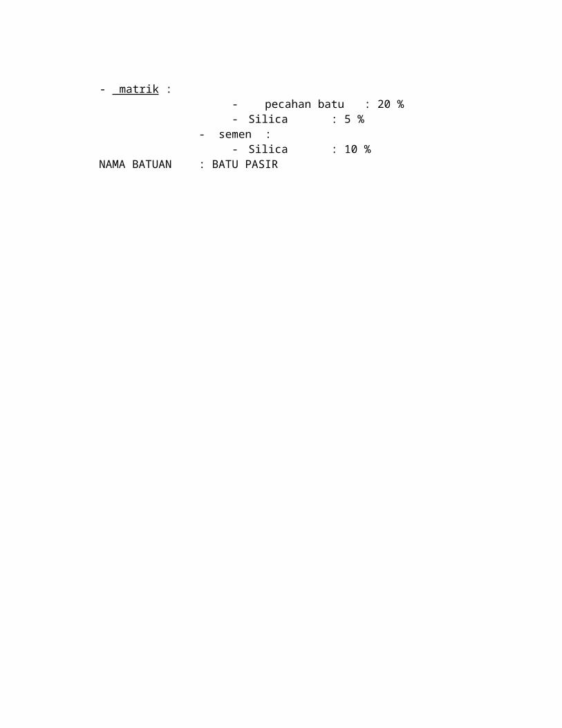
Figure 10.4 How to obtain the apparent dip to the Alignment Diagram
C. Using the table (the same concept as the use of Alignment Diagram)
Table 10.1 reading dip correction based on the angle formed between the strike and dip
direction
MAKE A cross section of GEOLOGY
The main requirement in the manufacture of geological cross sections are perpendicular to the
direction of the general strike, this will reduce the error factor in mengeplotkan dip in cross
section. If the withdrawal line is not perpendicular to the strike so obtained are apparent dip
(slope of the quasi-) which of course will vary with the amount of true dip.
For example:
On a geological map (Figure 10.5) made the geological cross section through A-A
'reconstruction are:
A. Making an incision in the direction perpendicular to the strike.
2. Creating a Base Line length as the incision line.
3. Creating End line split according to the height that we get does not have to start with a zero.
4. Mengeplotkan elevation contour cut and connecting it with the incision.
5. Describes the state geological pengeplotan including slope and structure of geological layers
that develop in the area / incision is
Figure 10.5
The appearance of the spread of rock on the cross section perpendicular to strike and the
appearance of order the stratigraphic.

Figure 10.6
a) integrated with the geological maps, b) geological cross section, c) stratigraphic columnar
CHAPTER II
GEOLOGY REGIONAL of BAYAT
A. General conditions of Bayat district
Location Bayat area is approximately 25 miles to the east of the city of Yogyakarta.Bayat
is generally divided into two physiographic regions namely the north of the Campus
Square, especially on the north side netting highway known as the Wedi Subdistrict Hills
area Jiwo (JiwoHills), and the area south of the Field Campus is a region of the Southern
Mountains (SouthernMountains).
B. Regional geomorphology
1. Hills Jiwo
Jiwo hills is inlier of Pre-Tertiary rocks and Tertiary sediments around Quartenary,
mainly composed of fluvio-volcanic sediments derived from G. Merapi.Elevasi
highest peaks there are no more than 400 m above sea level, so the hill is a
complete low hills.
Jiwo hills are divided into two regions, namely Jiwo Jiwo West and East are both
separated by a river in antecedent.Sungai Dengkeng own Dengkeng Jiwo complex
flows around the West, initially flowing towards South-Southwest, turned toward the
East and the North cut off the hills and the subsequent flow Northeast.Sungai
direction Dengkeng is the main dryer from the lowlands around Jiwo.Pembagian Hills
physiographic region Jiwo Bayat where East and West Hills are separated by the
River Dengkeng
This was originally a low-lying swampy area due to water flowing from the valley of
G.Merapi Mountain Selatan.Genangan water held back by this, in the northern hills
of sand Jiwo precipitate derived from the lava. Whereas in the south or in the
grooves in the hills Jiwo antarbukit is still water in the form of deposits of black loam,
a fertile sediment that Merapi is dried (reclaimed) by the Dutch colonial government
to serve the plantation.Reclamation is done degan how to create channels ditanggul
high enough so that water coming from the direction of G. Merapi will be collected in
the river while the low-lying areas of the original form of the marshes turned into dry
land used for plantations. Much of the area's original rawayang left in an area
surrounded by Puncak Sari, Monument, and the ax in the West Jiwo, known as the
Swamp Jombor.Rawa who left it to function as a tendon for the purpose of blood
irrigation farm on the plains north of East Hills Jiwo.
To flow the water from the swamp, made the artificial channel of the Southwest
corner of the swamp through the hills of metamorphic rock in G. Pegat flows east
through the village of Sedan and the river cut through the aqueduct next Dengkeng
seatan Jotangan again to the east.
The hills are composed of limestone hills extending to the back showed a blunted so
that the appearance of stem-peak-climbing is not so nyata.Tebing terbiku foothill not
so much plot-plot not found (Bawak-Temas hills in the East and the monument Jiwo-
ax in Jiwowest). For the region composed of metamorphic rocks foothill show more
tangible relief with cliffs terbiku kuat.The strength of draws result produces the
accumulation of sediment erosion at the foot of these hills are known as
colluvial.Puncak-top hills composed of rocks metamorphic stand out and some of
them tend to be shaped like a cone peak and peak Semanggu.Daerah Jabalkat
degan strong relief is found from the East Jiwo Konang peak to peak towards the
east and Jokotuo.Daerah Semanggu pendul around the summit is the only body that
hill entirely composed of rock beku.Kondisi pretty rough morphology similar
metamorphic hills, but relief is not as strong as indicated peak metamorphic hills.
a) Regional West Jiwo
West Jiwo consists of a row of hills G. Axes, G. Monument, G. Sari, G. Kebo,
G.Peacock, G. Scratches, and G. Jabalkat. G. Ax and G. The monument has a
layered limestone lithology, yellowish white, compact, thick layer of 20-40 cm. In the
area of G. Ax is mostly limestone is a massive body, suggesting an association with
the complex reef (reef). Between G. Monument and G. Sari limestones are having
direct contact with metamorphic rocks (mica schist).
Jiwo area West has hilltops north-south trending, represented by the peak Jabalkat,
Kebo, Merak, scratches, Budo, Sari, and the monument to the northern most part
turned to the west, namely G. Axes.

Metamorphic rocks in this area includes the area around G. Sari, G. Kebo,
G. Peacock, G. Scratches, and G. Jabalkat the general form of mica schist, filit, and
many contain mineral quartz. Around the region G. Sari, G. Kebo, and G. Peacock
on the mica schist found chunks of andesite and mikrodiorit. Lapukannya zones of
spheroidal weathering are often found at the edge of the village street. Igneous
rocks is a breakthrough that the body of mica schist. Good outcrops found at the
bottom of the small rivers that show stocky columns (columnar joints).
Metamorphic rocks are found also in the form of chlorite schist filit, talc schist, garnet
mieral there, quartzite and marble in G. Scratches, and G. Jabalkat. While at the top
of the hill itumasih found chunks of quartz conglomerate. While to the west of
G. Scratches in the rural area on the banks of Swamp Jombor still found the
remnants of quartz conglomerates and sandstones. To date the metamorphic rocks
are interpreted as the age of Pre-Tertiary rocks, sandstones and conglomerates but
put in Wungkal Formation.
In this area found two inlier (isolated hill) respectively in the hills and dunes
Salam.Bukit Wungkal Wungkal increasingly low due to the excavation of the
population to take a sharpening stone (stone wungkal) found on the hill.
b) Regional East Jiwo
This area includes the east of the Dengkeng which is a row of hills consisting of
Konang Mountain, Mount pendul, Mount Semangu, on the southern slope of Mount
pendul to reach the top, especially starting from the north of the Village Dowo found
sandstone layers, sometimes there is a £ ragmen mica schist in it. Whereas in the
eastern part of Mount pendul exposed stone gray clay-coated, hard, strong local
deformation of up to indestructible.
The relationship between rock units are still delivering a variety of possibilities for
contacts between units are sometimes covered by koluvial in dataran.Kepastian
stratigraphic rock units between the barn can be believed if it has any age absolut.
Althought measurements such diverse approaches as well as the reconstruction of
stratigraphic investigations have been carried out by the experts.
Jiwo hilly eastern hill-tops have an east-west trending, represented by peaks
Konang, pendul and Temas, J Mountain and Mount Jokotuo gold.
Konang mountain and Mount Semangu a body of rock-mica schist, berfoliasi quite
well, while Mount pendul an intrusive body is a rock metasedimen
mikrodiorit.Gunung Jokotuo (marble) where the place is found signs of Mount
Temas. But Pensee structure is a body of stone layered limestone.
In the north of Mount pendul gampmg nummulites found a rock outcrop, gray and
very compact, the surrounding limestone nummulites berlapis.Spreading sandstone
limestone are found in the local-nummulites local Padasan chiefly around the
village, with branching to the north, represented by peak Jokotuo and Bawak.
In the north and the south east there are hills Jiwo isolated hill that stands out and
alluvial plains nearby. Inlier (isolited hill) is a hill in the north and hills Jeto Lanang in
tenggara.Bukit Jeto generally composed of limestone, which is based Neogen is not
aligned in the metamorphic rocks, while the hill is composed entirely Lanang by
Neogen limestone.
2. Regional Statigrafi
The oldest rocks exposed in the Bayat area consists of metamorphic rocks form filtit,
schist, slate and marmer.Penentuan the right age for metamorphic rocks is still not
ada.Satu only indirect data to estimate its age is based on a single fossil that
Orbitolinafound by Bothe (1927) in the fragment conglomerate are showing age
Kapur. Because of the age of the oldest sedimentary rocks that cover metamorphic
rocks are early Tertiary age (Eocene limestone, sandstone), the age of metamorphic
rocks is called the Pre-Tertiary Rocks.
Is not aligned on a ride in metamorphic rocks are sandstone garnpingan not sarnpai
little limonite clay and stone, then on top of it covered by limestone containing
abundant fossil nummulites and the top terminated by Discocyclina limestone,
showing the marine environment dalarn. The existence of this large forminifera
bersarna with plangtonik foraminifera are very rare in the calcareous clay stone,
menunjukkna age of Middle Eocene to Upper Eisen. Officially, Eocene rocks are
called Wungkal-Garnping.Keduanya Formation, and Formation metamorphic rocks
Gamping Wungkal-intermediate igneous rocks intruded by type dioritik.
Diorite in the eastern region is the principal constituent of Jiwo pendul Mountain,
located in the eastern hills is the possibility of type dike.Singkapan Jiwo.Diorit
igneous rocks in Watuprahu (north side of Mount pendul) is stratigraphically above
the Eocene rocks are tilted toward the frozen selatan.Batuan This is stratigraphically
located beneath the sandstone and are still garnping layer sloped to the
south. Determination of age in the dike! pendul intrusion by Soeria Atmadja et al
(1991) produces about 34 million years, where the results are more or less according
to the theory Bemmelen (1949), which menfsirkan that igneous rocks are the neck /
neck from the Oligocene volcano. About the genetic and the generation of diorite in
the hills magmatisme Jiwo still require a more careful study of heart ¬.
Before the hands of the Eocene epoch, the area began tererosi.Erosi Jiwo was
caused by the removal or reduction of sea level during the late Oligocene peri
ode. The process of erosion has lowered the terse but the existing land surface,
followed by a period of transgression and deposition of rocks produces garnping
started in Middle Miocene time. Jiwo hills in the area has an equally characteristic
lithology of the formation is exposed lenih Oyo many of the Southern Mountains (¬
Nglipar Sambipitu area and surrounding areas).
In areas Bayat no marine sediments exposed on the Formation and Formation
Wungkal-Gampingan Oyo.Keadaan Mountains is very different here selatannya.Di
Baturagung in thickness of rock that characterized yesterday volkaniklastik turbidit
and sediment gravity flow deposition results of other well-exposed. These differences
may be caused by a complex fault system that separates the hills of the Mountains
Baturagung Jiwo who has been active since the Middle Tertiary.
During the Quaternary, the deposition of limestone has ended. Followed by removal
of the erosion process caused Jiwo Hills area turned into the terrestrial
environment.Volcanic sand from Merapi volcano is still active alluvial sedimentation
processes affecting mainly the north and northwest of the Hills Jiwo.
The state of South Pegunugan stratigraphy, from old to young, namely:
1. Kebo Formation, a volcanic sandstone, tuff, shale with insertions lava, Oligocene
age (N2-N3), the thickness of the formation about 800 meters.

2. Butak formation, with a thickness of 750 meters below the early Miocene (N4),
consisting of polomik breccia, sandstone and shale.
3. Formation breeze, a tuff, lapilli, pyroclastic breccia, sometimes there is the
insertion of clay and volcanic sandstone. Age N5-N9. The middle of the formation
Nglanggran meJ1iari.
4. Nglanggran Formation, a volcanic breccia, volcanic sandstone, lava flows and
breccias.
5. From the top Baturagung to the south, that is, toward the plains will be found
Wonosari Sambipitu Formation, Oyo Formation, Formation Wonosari danFormasi
Kepek
C. Regional Geological Structure
In the south Bayat, there is a low-lying east-west trending elongate, parallel to the foot of
South Mountain in the south. Bukit plateau is cut by faults and metamorphic rock
outcrops shifted to the northeast in the area Padasan, G. Semangu and turned north to
the Jokotuo, which is a bag of marble found among filit.Di Jiwo the north of the West is in
G.Monument, G. Axes and the Ngembel and the north, east and southeast of the East
Jiwo, Msing each in G. Jeto, G. Bawak, G. Temas and in G. Lanang, exposed
limestones which are not in harmony ride over older rocks. In the southeastern part of
G. Axes and in G. Jeto, limestone is riding on top of metamorphic rocks, are in Temas
beku.Batugamping ride on top of this rock consists of two facies that berbeda.Fasies the
first consisting of limestone algae, the appearance is not so jelas.Algae perlapisan
onkoid form structures in the form of a ball- ball measuring 2 to 5 cm. This facies is
found in G.Kampak, southern G.Tugu, G. Jeto, G. Bawak G.Temas.Fasies and in the
western part of the second form of layered limestone, which is between kalkarenit with
kalsilutit.Fasies perselingan layered limestones are found in Ngembel, northern
G.Monument, the eastern part of G. Temas and in G. Lanang. In some places
kalsilutitnya thickened lateral direction and turned into marl, as found in the northern
G. Monument.These facies do not show the structure of content-rich algae and
foraminifera plangon, probably deposited in shallow carbonate deeper structures
characterized by nendatan (slump structures) as seen in the eastern part Temas and in
G. Lanang. In the southern G.Temas found the contact between igneous rocks are
highly weathered batugamping.Batuan frozen, showing signs of cracks have been filled
mostly by iron oxide (limonite) and partially filled in the igneous kalsit.Retakan is no
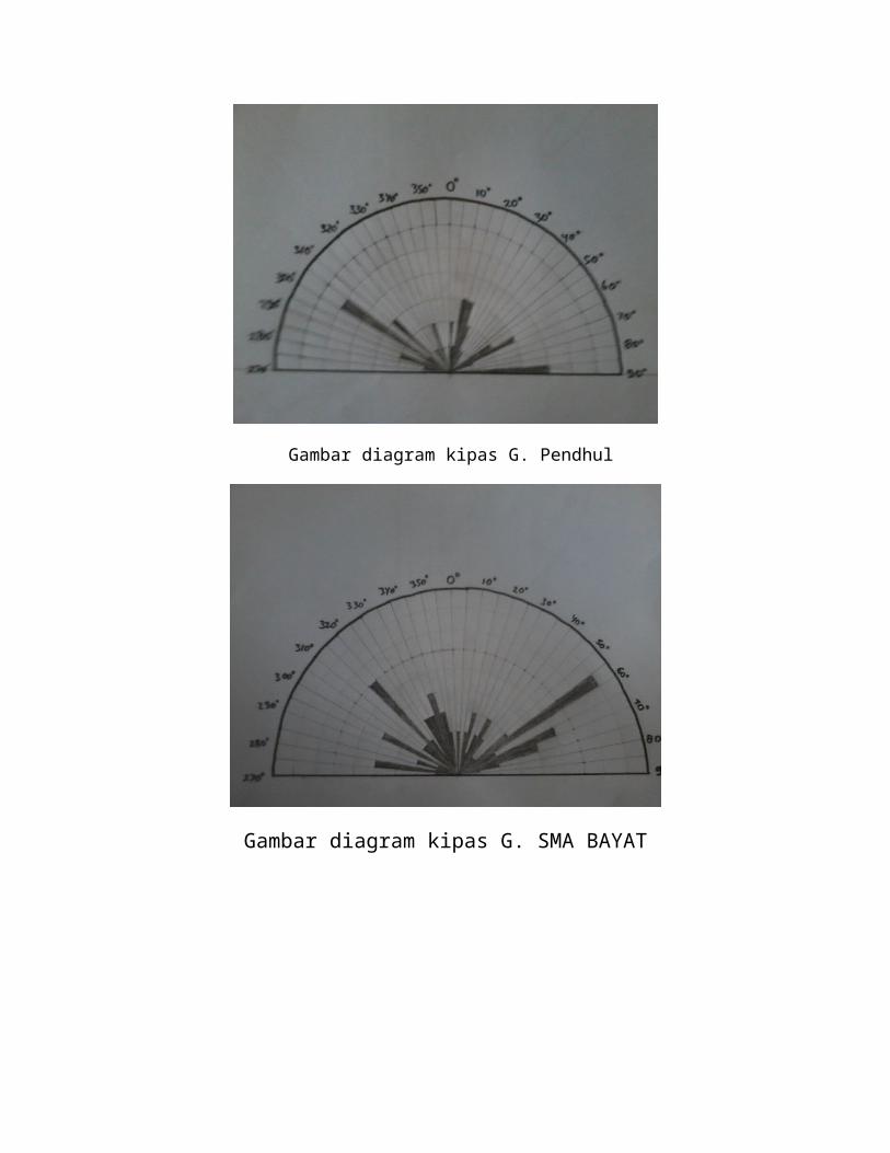
basis on this show that batugamping.Hal before the deposition of limestone, the rock has
undergone freezing cracks, filled by the results of its own in the form pelapukannya
limonit. After limestone deposition occurred, some of karbonatnya fills a gap caused by
cracks in the form of uric kalsit.Belakangan after uplifted and eroded limestone, some of
the calcite veins in igneous rocks exposed along the frozen tundra and were weathered,
forming tanah.Urat existing calcite dissolution and precipitation experienced back in
caliche forms, as many western in G. Temas and eastern and southern slopes
G.Pendul.
Based on its fossil content, limestone hills Jiwo neogen in this show or Miocene age N12
Based on the limestones of this age can be correlated with the formation Wonosari for
algae facies limestones, while the layered limestone facies is commensurate with the
formation Oya.Setelah limestone deposition, in the hills Jiwo not again found another
rock of Tertiary age. Quaternary era represented by lava breccias, sand deposits and
fluvio-Merapi volcanic clay sediments of the environmental rawa.Breksi black lava found
in the northern part of the hills Ngembel, in the form of andesite breccia with fragments
of diverse size, ranging from gravel to spread boulder. Fragmen generally float on the
silt-sized matrix to fine sand, is tufan.Gejala bedding and fossils found in the breccia
ini.Breccia TIDA is thought to originate from the activity of the lava flow of G. Merapi
from the northwest, which stopped due to hit Ngembel limestone hills, and occurs in the
Pleistocene.
CHAPTER IIIDATA, SYNTHESIS, ANALYSIS
1. Location: Mount Jeto
Plotting:
S 07 ° 45 '16.8 "
E 110 ° 40 '08 "
Measurement results:
- Strike / dip: N 21 ° E / 8 °
- Slope: 30 °
- Slope Direction: N 205 ° E
Rock outcrops found Dalkeith with a thickness of 16 meters.
2. Location: Mount Joko Old
Plotting:
S 07 ° 45 '37.2 "
E 110 ° 40 ° 29.6 '
Measurement results:
skiss metamorphic rocks): N 155 ° E- Liniasi (
- The boundary bet Dalkeith:ween metamorphic rocks
Coordinates: S 07 ° 45 '41 "
E 110 ° 40 '29.6 "
Elevation: 138 m
- Joko Old Stump
1) N 95 ° E / N 140 ° E
2) N 118 ° E / N 240 ° E
3) N 216 ° E / N 248 ° E
4) N 213 ° E / N 231 ° E
5) N 200 ° E / N 260 ° E
6) N 265 ° E / N 302 ° E
7) N 19 ° E / N 322 ° E
8) N 130 ° E / N 56 ° E
9) N 300 ° E / N 255 ° E
10) N 95 ° E / N 95 ° E
11) N 140 ° E / N 80 ° E
12) N 28 ° E / N 80 ° E
13) N 19 ° E / N 74 ° E
14) N 116 ° E / N 180 ° E
15) N 32 ° E / N 85 ° E
16) N 19 ° E / N 320 ° E
17) N 56 ° E / N 144 ° E
18) N 74 ° E / N 178 ° E
19) N 229 ° E / N 312 ° E
20) N 95 ° E / N 140 ° E
21) N 240 ° E / N 314 ° E
22) N 10 ° E / N 88 ° E
23) N 160 ° E / N 70 ° E
24) N 65 ° E / N 18 ° E
25) N 105 ° E / N 32 ° E
26) N 23 ° E / N 250 ° E
27) N 100 ° E / N 30 ° E
28) N 235 ° E / N 300 ° E
29) N 269 ° E / N 210 ° E
30) N 259 ° E / N 198 ° E
- There is a metamorphic rock:
A. Marble
2. Skiss
3. Filit
4. Gneiss
3. Location: Rear Bayat Community Health Center
Plotting:
S 07 ° 45 '57.2 "
E 110 ° 40 '23.9 "
Measurement results:
- Strike / dip: N 55 ° E / 40 °

N 43 ° E / 46 °
N 101 ° E / 38 °
- Found:
A. Frozen intrusive rocks (Dionite form Sill)
2. Mylonite
3. Graphite
4. Location: Mount Temas
Plotting:
S 07 ° 46 '02 "
E 110 ° 40 '40.6 "
Results of measurement:
- Strike / dip: N 47 ° E / 29 °
N 38 ° E / 24 °
N 355 ° E / 17 ° [UP]
- Boundary Stone Dalkeith - Frozen Stone
Coordinates: S 07 ° 45 '58.8 "
E 110 ° 40 '37 "5.
5. Location: Mount Lanang
Plotting:
S 07 ° 46 '36.6 "
E 110 ° 40 '52.4 "
Measurement results:
- Strike / dip: N 290 ° E / 60 °
N 281 ° E / 59 °
N 285 ° E / 51 °
- Slope: 31 °
- Slope Direction: N 355 ° E
- Found Mega Slump
Location: Mount Lanang
Plotting:
S 07 ° 46 '48 "
E 110 ° 40 '54.2 "
Measurement results:
- Strike / dip: N 20 ° E / 19 °
N 25 ° E / 16 °
N 40 ° E / 21 °
- Slope: 50 °
- Slope Direction: N 93 ° E
- Found limestone and sandstone rocks with a thickness of 15.7 meters.6.
6. Location: Home High School Bayat
Plotting:
S 07 ° 46 '52.2 "
E 110 ° 40 '45.3 "
Measurement results:
- Strike / dip: N 190 ° E / 79 °
N 350 ° E / 78 °
- List of high school Stump Bayat:
1. N 170 ° E / N 235 ° E
2. N 75 ° E / N 165 ° E
3. N 175 ° E / N 246 ° E
4. N 210 ° E / N 140 ° E
5. N 335 ° E / N 20 ° E
6. N 200 ° E / N 260 ° E
7. N 110 ° E / N 160 ° E
8. N 175 ° E / N 240 ° E
9. N 160 ° E / N 210 ° E
10. N 165 ° E / N 250 ° E
11. N 145 ° E / N 185 ° E
12. N 98 ° E / N 170 ° E
13. N 220 ° E / N 300 ° E
14. N 49 ° E / N 96 ° E
15. N 74 ° E / N 149 ° E
16. N 11 ° E / N 80 ° E

17. N 5 ° E / N 94 ° E
18. N 102 ° E / N 33 ° E
19. N 343 ° E / N 287 ° E
20. N 56 ° E / N 317 ° E
Location: Back SMA Bayat
Plotting:
S 07 ° 46 '57.8 "
E 110 ° 40 '49.4 "
Measurement results of Stump:
1. N 295 ° E / N 42 ° E
2. N 65 ° E / N 308 ° E
3. N 310 ° E / N 245 ° E
4. N 320 ° E / N 60 ° E
5. N 340 ° E / N 300 ° E
6. N 300 ° E / N 15 ° E
7. N 235 ° E / N 334 ° E
8. N 25 ° E / N 70 ° E
9. N 320 ° E / N 40 ° E
10. N 280 ° E / N 35 ° E
11. N 235 ° E / N 334 ° E
12. N 60 ° E / N 345 ° E
13. N 85 ° E / N 20 ° E
14. N 315 ° E / N 60 ° E
15. N 70 ° E / N 320 ° E
16. N 320 ° E / N 70 ° E
17. N 246 ° E / N 320 ° E
18. N 296 ° E / N 214 ° E
19. N 280 ° E / N 238 ° E
20. N 240 ° E / N 335 ° E
21. N 238 ° E / N 315 ° E
22. N 255 ° E / N ° 325E7.
7. Location: Mountain Tigers
Plotting:
S 07 ° 47 '05.5 "
E 110 ° 40 '12.5 "
Position:
- N 129 ° E / 33 °
N 9 ° E / 29 °
N 310 ° E / 32 °
- N 110 ° E / 40 °
N 98 ° E / 33 °
- N 140 ° E / 21 °
N 160 ° E / 16 °
N 170 ° E / 34 °
Intrusion:
S 07 ° 47 '7.1 "
N 170 ° 40 '13.9 "
Stump:
1. N 0 ° E / N 62 ° E
2. N 179 ° E / N 128 ° E
3. N 70 ° E / N 347 ° E
4. N 55 ° E / N 355 ° E
5. N 81 ° E / N 120 ° E
6. N 98 ° E / N 123 ° E
7. N 279 ° E / N 320 ° E
8. N 250 ° E / N 144 ° E
9. N 189 ° E / N 300 ° E
10. N 357 ° E / N 50 ° E
11. N 130 ° E / N 156 ° E
12. N 55 ° E / N 100 ° E
13. N 215 ° E / N 245 ° E
14. N 317 ° E / N 272 ° E
15. N 341 ° E / N 289 ° E

16. N 5 ° E / N 300 ° E
17. N 280 ° E / N 212 ° E
18. N 356 ° E / N 287 ° E
19. N 334 ° E / N 290 ° E
20. N 147 ° E / N 100 ° E
8. Location: Watu Prau
Plotting:
S 07 ° 46 '0.08 "
E 110 ° 40 '14.5 "
There are Numulites Dalkeith, clay, sand, and Flakes Quartzite Skiss intrusion.
Status of Sand Stone
N 50 ° E / 34 °
N 67 ° E / 28 °
N 60 ° E / 29 °
Boundary
• Numulites - Skiss
1. S 07 ° 46 '10 "
E 110 ° 39 '59.1 "
2. S 07 ° 45 '59.8 "
E 110 ° 40 '15 "
3. S 07 ° 46 '39.1 "
E 110 ° 40 '14.1 "
4. S 07 ° 46 '59.1 "
E 110 ° 40 '14.2 "
5. S 07 ° 46 '00.9 "
E 110 ° 40 '00 "
9. Location: Sumber Rejo (Back Home)
Plotting:
S 07 ° 46 '35.9 "
E 110 ° 40 '23.2 "
Measurement Results
- Strike / dip: N 65 ° E / 35 °
N 55 ° E / 40 °
N 70 ° E / 21 °
N 309 ° E / 18 °
N 304 ° E / 19 °
- Stump:
1. N 322 ° E / N 255 ° E
2. N 347 ° E / N 289 ° E
3. N 300 ° E / N 11 ° E
4. N 324 ° E / N 224 ° E
5. N 262 ° E / N 161 ° E
6. N 160 ° E / N 194 ° E
7. N 112 ° E / N 175 ° E
8. N 26 ° E / N 312 ° E
9. N 84 ° E / N 158 ° E
10. N 282 ° E / N 8 ° E
11. N 188 ° E / N 133 ° E
12. N 130 ° E / N 176 ° E
13. N 146 ° E / N 123 ° E
14. N 133 ° E / N 181 ° E
15. N 145 ° E / N 216 ° E
16. N 30 ° E / N 80 ° E
17. N 350 ° E / N 275 ° E
18. N 11 ° E / N 90 ° E
19. N 118 ° E / N 180 ° E
20. N ° E / N ° E
10. Location: Jerukan
Plotting:
S 07 ° 46 '34.6 "
E 110 ° 40 '5.8 "
Data:
- Strike / dip: N 35 ° E / 42 °
N 37 ° E / 43 °
- Boundary-Frozen Sediment: S 07 ° 46 '35.1 " ; E 110 ° 40 '5.8 "
- Found Frozen Intrusion rocks and silt
11. Location: Mount Pendul
Plotting:
S 07 ° 46 '18.2 "
E 110 ° 40 '20.5 "
Measurement results:
- Strike / dip: N 47 ° E / 15 °
N 50 ° E / 35 °
- Slope: N 178 ° E
- Direction Slope: 15 °
- Found igneous intrusions, Mylonite
- Found a metamorphic rock & liniasi N 35 ° E
- Limit silt & Filit: S 07 ° 46 '18.2 " ; E 110 ° 40 '20.4 "
- Metamorphic N 63 ° E
- Vein calcite ± 5mm
- Coordinate Limits
1. S 07 ° 46 '20.6 "
E 110 ° 40 '15.6 "
2. S 07 ° 46 '21.0 "
E 110 ° 40 '16.0 "
3. S 07 ° 46 '19.4 "
E 110 ° 40 '19.4 "
4. S 07 ° 46 '19.2 "
E 110 ° 40 '21.6 "
5. S 07 ° 46 '20.2 "
E 110 ° 40 '22.1 "
- Stump:
1. N 355 ° E / N 305 ° E
2. N 98 ° E / N 170 ° E
3. N 245 ° E / N 315 ° E
4. N 203 ° E / N 149 ° E
5. N 122 ° E / N 192 ° E
6. N 190 ° E / N 266 ° E
7. N 90 ° E / N 24 ° E
8. N 65 ° E / N 135 ° E
9. N 185 ° E / N 165 ° E
10. N 116 ° E / N 197 ° E
11. N 183 ° E / N 249 ° E
12. N 126 ° E / N 58 ° E
13. N 270 ° E / N 192 ° E
14. N 122 ° E / N 192 ° E
15. N 90 ° E / N 122 ° E
16. N 65 ° E / N 135 ° E
17. N 162 ° E / N 236 ° E
18. N 106 ° E / N 30 ° E
19. N 125 ° E / N 20 ° E
20. N 110 ° E / N 200 ° E
ROCK DESCRIPTION PER STATION
Station I. Mount Jetho
1.Types Of Rocks :Clastic Sedimentary Carbonate
Stone Colors : Yellow-White
Structure : Massive
Texture : - Grain Size : The Sand Is Being
- Sorting : Good
- Forms Of Items: Rounded
- Pack : Closed
Composition :
- Fragments : -
- Matrices : Calcite 30%
- Cement : 65% Carbonate
Others : 5% Are Uric Katsit
ROCK NAME : PACKSTONE
2. Types Of Rocks :Clastic Sedimentary Carbonate
Stone Colors : Yellow-White
Structure : Massive
Texture : - Grain Size : The Sand Is - Fine Sand
- Sorting : Good
- Forms Of Items: Rounded
- Pack : Closed
Composition:
- Fragments : -
- Matrices : Calcite 25%
- Cement : 75% Carbonate
Others :-
ROCK NAME : WACKSTONE
Station II. Joko Mount Tuo1. ROCK TYPE : MetamorphicCOLOR : Golden BrownSTRUCTURE : Foliasi - SkistoseTEXTURE : LapidioblastikMINERAL COMPOSITION:
-Quartz : 20%
- Muscovite : 70%
- Feldspar : 10%
Metamorphic TYPE : Regional
DEGREES Metamorphosis:
ROCK NAME : SKISS
2. ROCK TYPE : Metamorphic
COLOR : White Brownish
STRUCTURE : Hornfelsk
TEXTURE : Granoblastik
MINERAL COMPOSITION:
- Calcite : 30%
- Dolomite : 70%
Metamorphic TYPE : Regional
DEGREES Metamorphosis: Low
ROCK NAME : MARBLE
3. ROCK TYPE : Metamorphic
COLOR : Blackish
STRUCTURE : Phylitic
TEXTURE : Lepidoblastik
MINERAL COMPOSITION:
- Quartz : 60%
- Chlorite : 40%
Metamorphic TYPE : Regional
DEGREES Metamorphosis:
ROCK NAME: FHYLITE
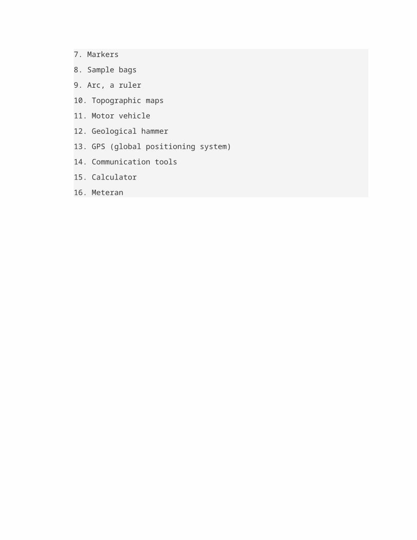
4. ROCK TYPE : Metamorphic
COLOR : Brownish
STRUCTURE : Gneissik
TEXTURE : Nematoblastik
MINERAL COMPOSITION:
- Biotite : 30%
- Feldspar : 70%
- Quartz : -
- Muscovite : -
Metamorphic TYPE : Regional
DEGREES Metamorphosis: Low
ROCK NAME : GNEISS
Station III. Behind The Health Center
1. Types Of Rocks : Clastic Sediments
Stone Color : White Gray
Structure : Parallel Lamination
Texture : - The Size Of Grain : Sand Is
- Sorting : Good
- Forms Of Items : Rounded
- Pack : Closed
Composition:
- Fragments :- Broken Stone: 35%
- Quartz: 30%
- Hornblende: 10%
- Biotite: 5%
- Matrix :- Broken Stone: 5%
- Quartz: 5%
- Silica: 5%
- Cement :- Silica: 5%
Others:
ROCK NAME : QUARTZ SAND
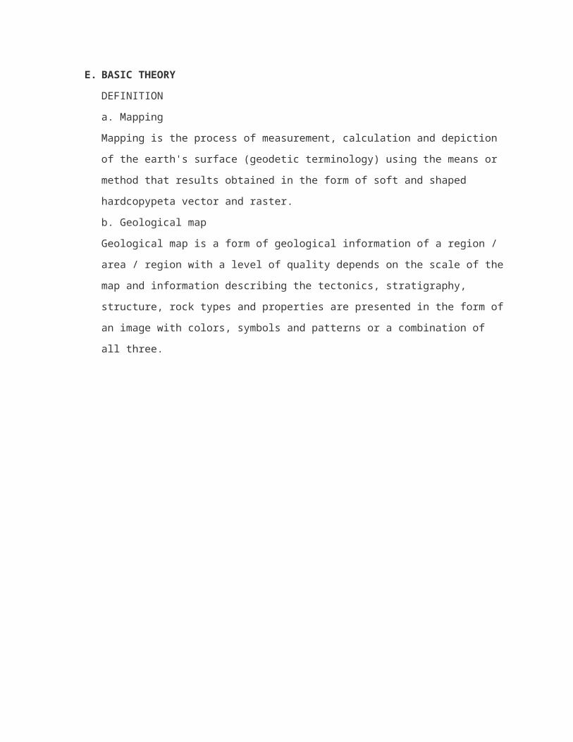
2. Types Of Rocks : Clastic Sediments
Stone Color : White Yellow
Structure : Massive
Texture : - Grain Size: Silt
- Sorting: Good
- Forms Of Items: Rounded
- Pack: Closed
Composition:
- Fragments :- Broken Stone : 30%
- Quartz : 20%
- Hornblende : 10%
- Fheldspar : 5%
- Matrix :- Broken Stone : 15%
- Quartz : 25%
Others :
ROCK NAME : SILT
3. ROCK TYPE : Metamorphic
COLOR : Brown-Black
STRUCTURE : Foliasi - Skistose
TEXTURE : Lapidioblastik
MINERAL COMPOSITION:
- Quartz : 20%
- Muscovite : 70%
- Feldspar : 10%
Metamorphic TYPE : Regional
DEGREES Metamorphosis:
ROCK NAME : SKISS
4. ROCK TYPE : Metamorphic
COLOR : Blackish
STRUCTURE : Phylitic
TEXTURE : Lepidoblastik
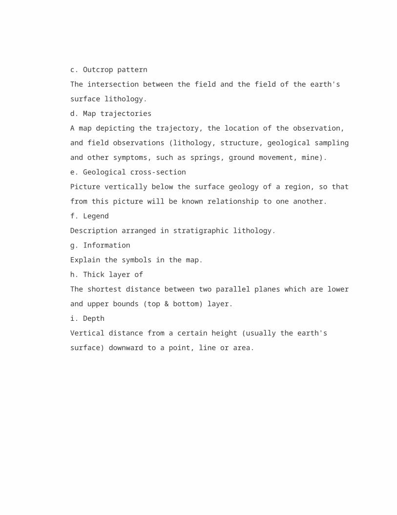
MINERAL COMPOSITION:
- Quartz : 60%
- Chlorite : 40%
Metamorphic TYPE : Regional
DEGREES Metamorphosis:
ROCK NAME : FHYLITE
5. ROCK TYPE : Metamorphic
COLOR : White Blackish
STRUCTURE : Hornfelsk
TEXTURE : Granoblastik
MINERAL COMPOSITION:
- Calcite : 30%
- Dolomite : 70%
Metamorphic TYPE : Regional
DEGREES Metamorphosis: Low
ROCK NAME : MARBLE
6. ROCK TYPE : Frozen Intermediete
COLOR : Gray-Green
STRUCTURE : Massive
TEXTURE : - Hipokristalin
- Porfiro Afanitik
- Subhedral – Anhedral
COMPOSITION:
- Plagioclase : 40%
- Honrblende : 10%
- Biotite : 16%
- Pyroksin : 30%
- Quartz : 4%
OTHER : -
ROCK NAME : Diorite
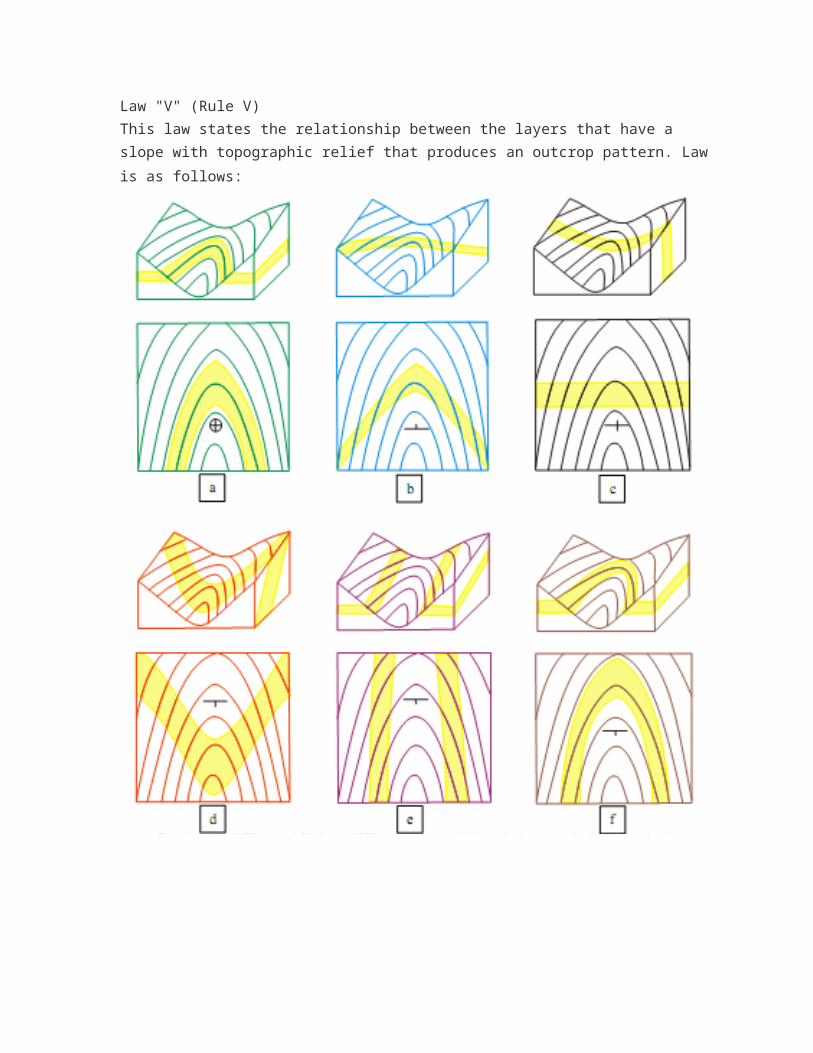
Station IV. Mount Lanang
1. Types Of Rocks : Clastic Sedimentary Carbonate
Stone Colors : Yellow-White
Structure : Massive
Texture : - Grain Size : The Sand Is Being
- Sorting : Good
- Forms Of Items: Rounded
- Pack : Closed
Composition :
- Allocem : -
- Mitrit : Calcite 35%
- Sparit : 65% Carbonate
Others :
ROCK NAME : PACKSTONE
2. Types Of Rocks : Clastic Sedimentary Carbonate
Stone Colors : Yellow-White
Structure : Massive
Texture : - Grain Size : The Sand Is - Fine Sand
- Sorting : Good
- Forms Of Items: Rounded
- Pack : Closed
Composition :
- Allocem : -
- Mitrit : Calcite 25%
- Sparit : 75% Carbonate
Others : -
ROCK NAME : WACKSTONE
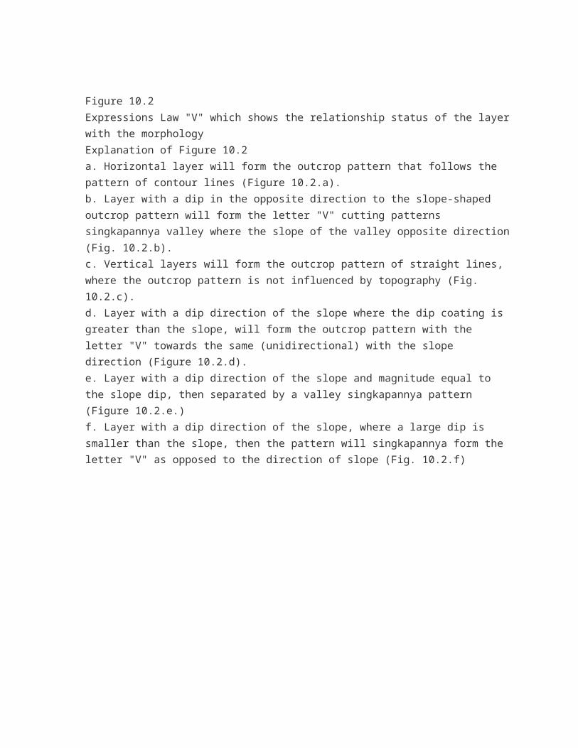
Station V. High School Freshman
1. Types Of Rocks : Clastic Sediments
Stone Color : Greyish White
Structure : Laminate
Texture : - The Size Of Grain : Sand Is
- Sorting : Good
- Forms Of Items : Round Responsibility - Rounded
- Pack : Closed
Composition :
- Fragments :- Broken Stone: 30%
- Quartz: 10%
- Silica: 25%
- Matrix :- Silica: 20%
- Cement :- Silica: 10%
ROCK NAME : SAND TUFFAN
2. Types Of Rocks : Sedimentary Pyroclastic
Stone Color : Greyish
Structure : Graded Bedding
Texture : - Grain Size : Coarse Sand - Gravel
- Sorting : Medium
- Forms Of Grain : An Angled Responsibility - An Angle
- Pack : Closed
Composition :
- Fragments :- Broken Stone : 35%
- Quartz : 5%
- Hornblende : 10%
- Biotite : 5%
- Pyroksin : 15%
- Matrix :- Broken Stone : 15%
- Quartz : 5%
- Cement :- Silica : 10%
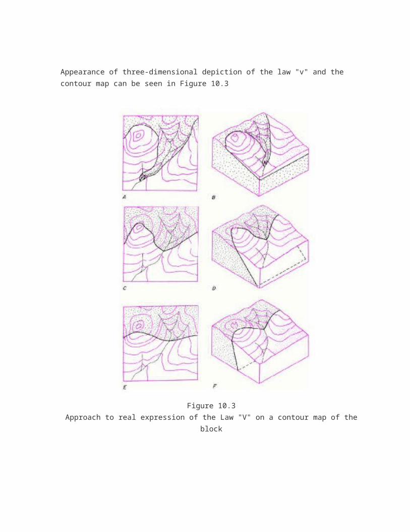
ROCK NAME: Breccia TUFFAA
Station VI. Mount Macan
1. Types Of Rocks : Clastic Sediments
Stone Color : Greyish White
Structure : Laminate
Texture : - The Size Of Grain : Sand Is
- Sorting : Good
- Forms Of Grain : An Angled Responsibility - An Angle
- Pack : Closed
Composition :
- Fragments :- Broken Stone : 30%
- Quartz : 10%
- Silica : 10%
- Matrix :- Broken Stone : 20%
- Silica : 5%
- Cement :- Silica : 10%
Others :
ROCK NAME : Sandstone TUFFAA
2. Types Of Rocks : Clastic Sediments
Stone Color : Yellowish White
Structure : Masive
Texture : - The Size Of Grain : Sand Is
- Sorting : Good
- Forms Of Grain : An Angled Responsibility - An Angle
- Pack : Closed
Composition :
- Fragments :- Broken Stone : 30%
- Quartz : 20%
- Hornblende : 10%
- Feldspar : 5%
- Matrix :- Muscovite : 10%
- Quartz : 25%
- Cement :-
ROCK NAME : SILT STONE
3. ROCK TYPE : Frozen Intermediete
COLOR : Gray-Green
STRUCTURE : Massive
TEXTURE : - Hipokristalin
- Porfiro Afanitik
- Subhedral – Anhedral
COMPOSITION:
- Plagioclase : 40%
- Honrblende : 10%
- Biotite : 16%
- Pyroksin : 30%
- Quartz : 4%
OTHER : -
ROCK NAME : DIORITE
Stasion VII. Watu Prau
1. Types Of Rocks : Clastic Sedimentary Carbonate
Stone Colors : Gray
Structure : Massive
Texture : - Grain Size : Kalsilutit
- Sorting : Poor
- Forms Of Items: Rounded - angled
- Pack : Opened
Composition :
- Allocem : -Numulites fossils : 45%
- Quartz : 5%- Calcite : 20%
- Mitrit : -Carbonate : 10%- Sparit : -Carbonate : 20%Others :
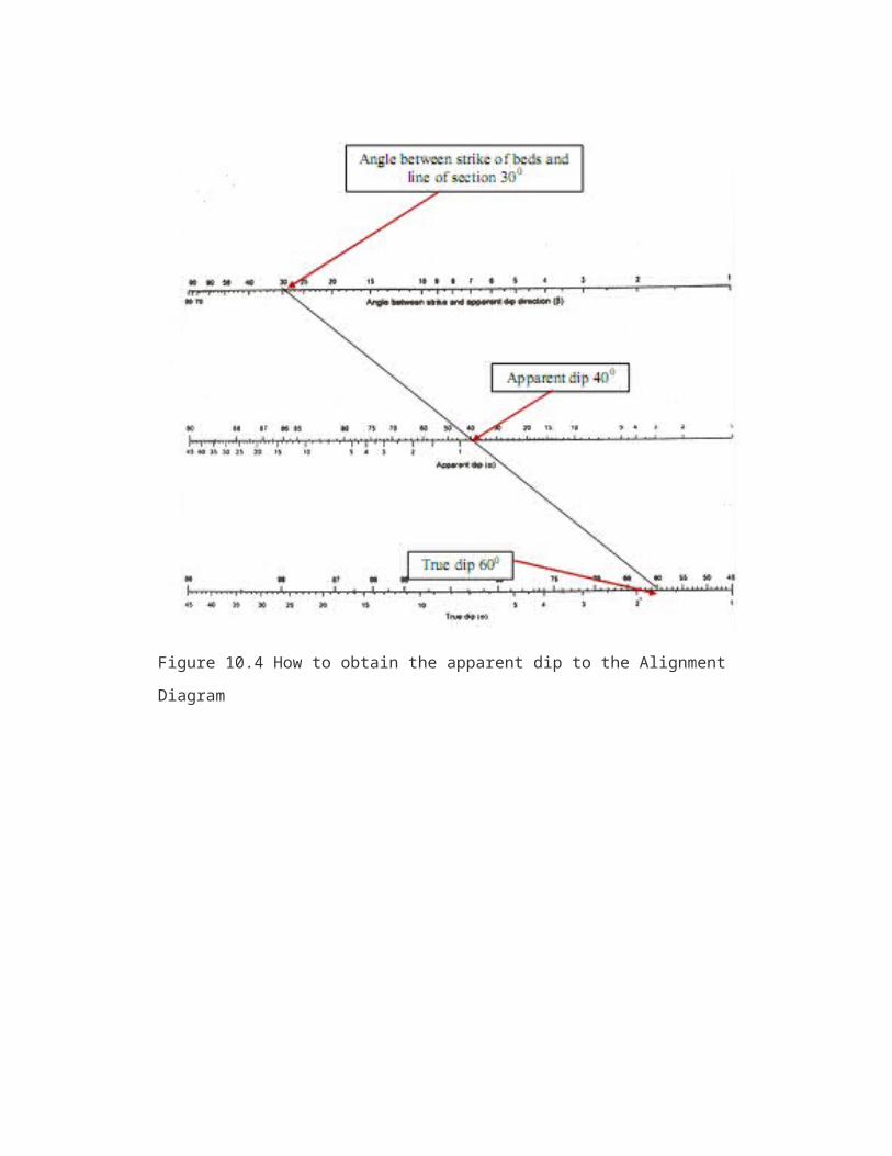
ROCK NAME : PACKSTONE
2. Types Of Rocks : Clastic Sediments
Stone Color : White Gray
Structure : Parallel Lamination
Texture : - The Size Of Grain : Sand Is
- Sorting : Good
- Forms Of Items : Rounded
- Pack : Closed
Composition:
- Fragments :- Broken Stone : 30%
- Quartz : 10%
- Silica : 25%
- Matrix :- Broken Stone : 20%
- Silica : 5%
- Cement :- Silica : 10%
Others:
ROCK NAME : SANDSTONE
3. ROCK TYPE : Frozen Intermediete
COLOR : Gray-Green
STRUCTURE : Massive (wether)
TEXTURE : - Hipokristalin
- Porfiro Afanitik
- Subhedral – Anhedral
COMPOSITION:- Plagioclase : 40%- Honrblende : 10%- Biotite : 16%- Pyroksin : 30%- Quartz : 4%
OTHER : -ROCK NAME : DIORITE
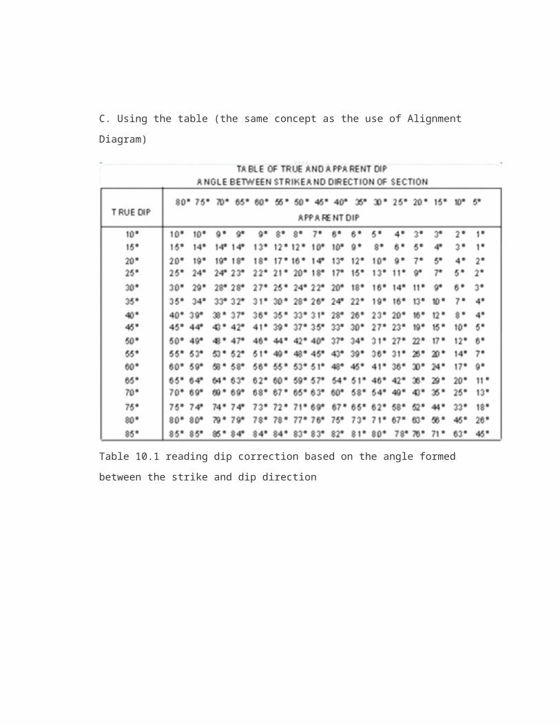
ANALYSIS
FAN DIAGRAM
a. Stasiun SMA Bayat
NO.ARAH
NOTASI JUMLAHN….°E N….°E
1 0-5 181-185 II 22 6-10 186-190 03 11-15 191-195 II 24 16-20 196-200 III 35 21-25 201-205 I 16 26-30 206-210 II 27 31-35 211-215 III 38 36-40 216-220 II 29 41-45 221-225 I 1
10 46-50 226-230 I 111 51-55 231-235 III 312 56-60 236-240 IIIIIIII 813 61-65 241-245 II 214 66-70 246-250 IIIII 515 71-75 251-255 IIII 416 76-80 256-260 II 217 81-85 261-265 I 118 86-90 266-270 019 91-95 271-275 I 120 96-100 276-280 IIII 421 101-105 281-285 I 122 106-110 286-290 II 223 111-115 291-295 I 124 116-120 296-300 IIII 425 121-125 301-305 026 126-130 306-310 II 227 131-135 311-315 II 228 136-140 316-320 IIIIII 629 141-145 321-325 II 230 146-150 326-330 I 131 151-155 331-335 III 332 156-160 336-340 III 333 161-165 341-345 IIII 434 166-170 346-350 III 335 171-175 351-355 II 236 176-180 356-360 0
b. Stasiun G.Pendhul
NO.ARAH
NOTASI JUMLAHN….°E N….°E
1 0-5 181-185 II 22 6-10 186-190 I 13 11-15 191-195 III 34 16-20 196-200 III 35 21-25 201-205 II 26 26-30 206-210 I 17 31-35 211-215 08 36-40 216-220 09 41-45 221-225 0
10 46-50 226-230 011 51-55 231-235 012 56-60 236-240 II 213 61-65 241-245 III 314 66-70 246-250 I 115 71-75 251-255 016 76-80 256-260 017 81-85 261-265 018 86-90 266-270 IIII 419 91-95 271-275 020 96-100 276-280 I 121 101-105 281-285 022 106-110 286-290 II 223 111-115 291-295 024 116-120 296-300 I 125 121-125 301-305 IIIII 526 126-130 306-310 I 127 131-135 311-315 III 328 136-140 316-320 029 141-145 321-325 030 146-150 326-330 I 131 151-155 331-335 I 132 156-160 336-340 033 161-165 341-345 II 234 166-170 346-350 I 135 171-175 351-355 036 176-180 356-360 0
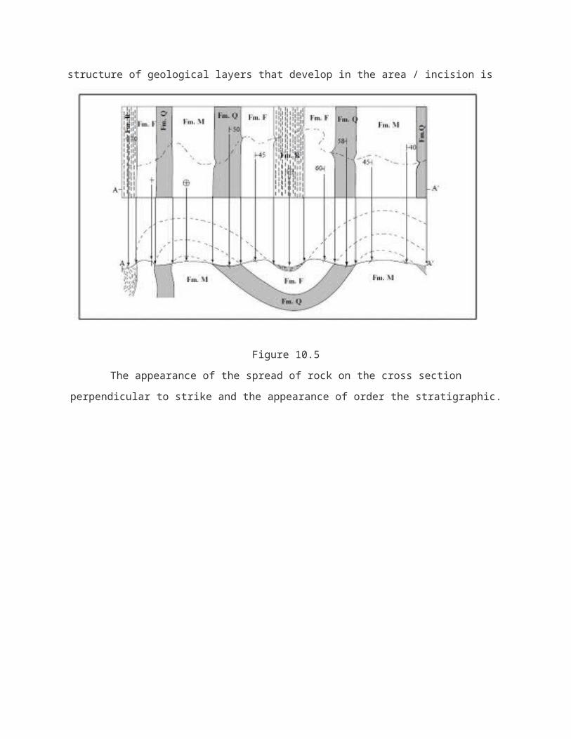
Gambar diagram kipas G. Pendhul
Gambar diagram kipas G. SMA BAYAT
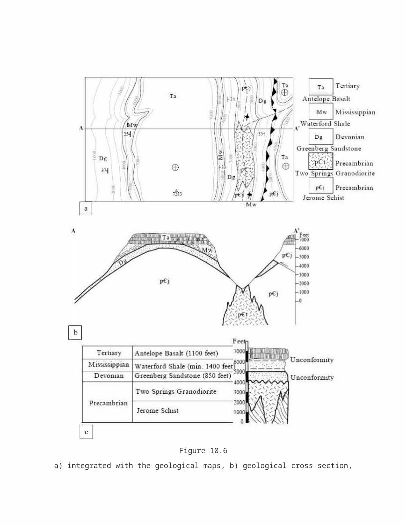
PENUTUP
A. Kesimpulan
Perbukitan jiwo timur terdapat 3 jenis batuan yaitu; batuan beku (intrusi), batuan sedimen dan
batuan metamorf. Batuan beku menerobos batuan lainnya (sill, dike) terutama batuan sedimen.
Dengan begitu batuan beku menjadi batuan termuda setelah alluvial, kemudian disusul batuan
sedimen yaitu batu gamping numulites, batu pasir dan batu lanau. Kemudian ditemukan batuan
breksi alas, menjadikan batuantersebut menjadi batuan tertua sebelim batuan metamorf.
Dari data yang kita dapat kemungkinan besar daerah Jiwo Timur banyak terdapat structure
geologi (sesar, lipatan, patahan,dll) karena ditemukan tanda-tanda adanya zona
hancuran(milonitik), adanya intrusi yang menunjukan adanya zona lemah dan dijumpai batuan
yang kompleks dalam suatu lokasi yang terbilang tidak luas.
Perlu adanya penelitian lebih lanjut supaya pemetaan geologi atau pengungkapan sejarah
daerah Jiwo timur, bayat bisa memperoleh hasil yang maksimal.
B. Kendala selama kegiatan
Untuk kendala yang besar, alhamdulilah kami tidak mengalaminya. Hanya kendala kecil
saja yang kami dapatkan selama kegiatan ini, diantaranya :
a. Ban sepeda motor bocor
b. Terlalu banyak bercanda
c. Kehilangan pengaris
d. Gps kehabisan battrey
C. Kritik dan Saran
Kami memiliki beberapa kritik sebagai berikut:
a. Seharusnya bapak/ibu guru mengawasi langsung para siswa ketika praktikum di
lapangan
b. Untuk teman-teman ketika praktikum jangan banyak bercanda
c. Peta lapangan sebaiknya dikasih lebih banyak untuk cadangan
d. Tempat mandi kurang banyak
e. Untuk teman-teman ketika berkendara jangan ugal-ugalan

Kami memiliki beberapa saran sebagai berikut:
a. Sebelum ke lapangan sebaiknya siswa dibekali ilmu secara matang supaya ketika
praktikum dapat maksimal
b. Perlu adanya penelitian lebih lanjut supaya pemetaan geologi atau pengungkapan
sejarah daerah Jiwo timur, bayat bisa memperoleh hasil yang maksimal.