sih~ 'se::>jnosecj ibjmbn lo uo!s!!o 'le!4~ ~rt~)i...(usdoi/usda, 2002) (3) a...
TRANSCRIPT
-'J}~~~7;-:Aq paJ\oJddv
:elBO
~Md 'Je~!JJO luewe6euell'J eJ!::IleUo!6e~:elBO
SIH~ 'se~JnOSeH leJmln~ Jo UO!S!"!O 'Je!4~
(1'~-£171~~~ ..~()I)' U1J~~77~;7~- : e} e a
SIH~ 'se::>JnoseCj IBJmBN lO UO!S!"!O 'le!4~
~rt~)I:Aq peMe!J\e~
>lJo~eN ~SI~O~ ueeueJJe~!pelflJ 'Je~! ewe6euelflJ eJ!::I~ 0 J / 1 ~ :e~eo \ :fi.q peJedeJd
'-
900Z
UUId :~U~UI~~UUUW ~l!d PUUIPI!.M
~lUd[ IUUO!~u.N: spuuIsI I~uuuqJ
EXECUTIVE SUMMARY The wildland fire management policies of the National Park Service (NPS) support Channel Islands National Park’s (CHIS) resource management goals. The primary goals are to provide for firefighter and public safety, protect natural and cultural resources, and protect human developments from all wildland fire. The Channel Islands National Park will suppress all wildland fires. The park may use prescribed fire to obtain resource objectives. The environmental compliance for prescribed fire will be carried out separate from this Fire Management Plan. This Wildland Fire Management Plan contains the following program direction: To guide the decision-making process for appropriate fire management response strategies prioritizing safety of life, resources and property. Provide a framework for fuels management through the use of prescribed fire and mechanical treatments. To provide a basis from which to cooperate more fully in planning and implementing a wildland fire program across agency boundaries. Program operations included in the Fire Management Plan (FMP) are:
1) preparedness 2) prevention 3) suppression 4) fuels management.
Applicable resource goals and objectives are derived from approved agency resource and general management plans. The FMP is organized to combine the latest scientific knowledge, including regional and local studies, with policy direction from the National Park Service, the Department of the Interior, the Federal Wildland and Prescribed Fire Management Policy and Program Review (USDI/USDA1995), and other Federal Government level wildland fire policies such as the National Fire Plan to accomplish resource and fire management goals and objectives. The intent of the plan is primarily operational in nature. This Plan is in compliance with the requirements found in the National Environmental Policy Act (NEPA). It is a suppression only fire management plan, proposing only fire suppression activity and debris burning. Research and prescribed burns will be covered by an environmental document prepared specifically for each burn.
TABLE OF CONTENTS Page
Executive Summary Table of Contents I. Introduction 1
A. The Fire Management Plan 1
B. Collaborative Processes Used to Develop the Fire Plan 1
C. Implementation of Federal Fire Management Policy 2
D. Compliance 3
E. Authorities for Implementing the Fire Plan 4 II. Land Management Planning and Fire Policy 4
A. NPS Management Policies Related to Fire Management 5
B. Channel Islands National Park Enabling Legislation 7
C. Channel Islands National Park General Management Plan 7
D. Channel Islands National Park Resource Management Plan 9
E. Meeting GMP and RMP Goals through the Fire Plan 10 III. Wildland Fire Management Strategies 10
A. General Management Considerations 10
B. Wildland Fire Management Goals 12
C. Wildland Fire Management Options 15
D. Description of Wildland Fire Management Strategies by Fire Management Unit 16
E. Wildland Fire Management Situation 20
1. Historic Weather Analysis 20

2. Fire Season 23
3. Fuel Characteristics 23
4. Fire Regime Alteration and Condition Class 24
5. Control Problems & Dominanat Topographical Features 28
6. Other Management Considerations 29 IV. Wildland Fire Management Program Components 30
A. General Implementation Procedures 30
B. Wildland Fire Suppression 30
C. Wildland Fire Use 43
D. Prescribed Fire 43
E. Non-Fire Fuel Treatment Applications 49
F. Emergency Rehabilitation and Restoration 50 V. Organizational and Budgetary Parameters 50
A. Organizational Structure of the Fire Management Program 50
B. Fire Management Organization 55
C. Wildland Fire Use Certification 56
D. Interagency Coordination 56 VI. Monitoring and Evaluation 57
A. Monitoring Programs 57
B. NPS Fire Monitoring Handbook 57
C. Fire Monitoring Plan 57 VII. Fire Research 58 VIII. Public Safety 58
A. Public Safety Issues and Concerns 58
B. Mitigating Safety Issues 58 IX. Public Information and Education 59
A. Public Information Capabilities and Needs 59
B. Step-Up Public Information Activities 60 X. Protection of Sensitive Resources 61
A. Cultural and Historic Resources Needing Protection 61
B. Natural Resources Needing Protection 62
C. Developments, Infrastructure, and Improvements Needing Protection 63
XI. Fire Critiques and Annual Plan Review 63 XII. Consultation and Coordination 63 XIII. Appendicies
Appendix A: References Cited Appendix B: 2001 Federal Wildland Fire Management Policy compliance Appendix C: Definition of Terms Appendix D: MIST Appendix E: Channel Islands Complexity Guide Appendix F: Agreements Appendix G: Tables and Graphs
1. Average monthly temperatures Channel Islands National Park 2. Average monthly rainfall Channel Islands National Park 3. Regional Santa Ana wind pattern 4. Santa Ana wind pattern in the Santa Barbara Channel 5. Seasonal Santa Ana wind days 6. Seasonal changes in live fuel moisture 7. Fire frequency and total area burned per month 8. Channel Islands vegetation types & fuel models 9. Vegetation maps of the northern Channel Islands 10. Cumulative total area burned by age class 11. Distribution of Channel Islands fire sizes 12. Age Classes of vegetation burned in SMMNRA 13. Fire Condition Class definitions
Appendix H: Physical and Biotic Characteristics Appendix I: Fire Danger and Activity Levels
Channel Islands National Park Fire Management Plan
- 1 -
INTRODUCTION
A. The Fire Management Plan National Park Service (NPS) wildland fire management is essential to the protection of human life and property, the protection and management of irreplaceable natural and cultural resources, and to the accomplishment of the NPS mission. The Channel Islands National Park (Channel Islands) Wildland Fire Management Plan (FMP) is the primary planning document directing park wildland fire management activities at Channel Islands. These activities include preparedness planning and activities, fire staffing and training, prevention, suppression, and the use of fuel treatments to achieve management and resource management objectives. This FMP meets the requirement of Director's Order-18 (DO-18) that all NPS park units with burnable vegetation have a wildland fire management plan approved by the superintendent. Channel Islands will review and update the fire management plan annually. Annual review ensures that the FMP continues to conform to current laws, objectives, procedures and strategies. A comprehensive plan revision, and National Environmental Policy Act (NEPA) compliance review, is required every five years. Channel Islands will provide a digital copy of each approved Fire Management Plan and all subsequent amendments to the NPS Fire Management Program Center (FMPC), located at the National Interagency Fire Center (NIFC), in Boise, Idaho.
B. Collaborative Processes Used to Develop This Plan The development of this Fire Management Plan is based on park planning documents that sought participation and information from land and fire management partners, academic experts, neighboring communities and other NPS programs during their creation. These documents include the Channel Islands National Park General Management Plan (1985), Land Protection Plan (1984), Santa Rosa Island Development Concept Plan (1995) and cooperative agreements with The Nature Conservancy, United States Navy, and the United States Coast Guard. Channel Islands National Park is comprised of five of the eight Channel Islands, located off the west coast of California, as well as the submerged lands and waters within one nautical mile of these islands. The United States Coast Guard owns East Anacapa Island and the light station located there. The United States Navy owns San Miguel and Prince Islands. They lease a several-acre complex on Santa Cruz Island from The Nature Conservancy. The Nature Conservancy owns approximately three-quarters of Santa Cruz Island. Within the Nature Conservancy lands is the Santa Cruz Island Reserve, operated by the University of California Natural Reserve System. These organizations were consulted during the formation of the FMP. Additionally, the following organizations were supplied with the final version of the FMP: Federal
• United States Geological Survey/Biological Resource Division • National Marine Fisheries Service
Channel Islands National Park Fire Management Plan
- 2 -
• United States Fish & Wildlife Service • United States Forest Service/Los Padres National Forest • Channel Islands National Marine Sanctuary • United States Navy • United States Coast Guard
Federally Recognized Tribes
• Santa Ynez Band of Chumash Indians State
• State Of California Clearing House • Central California Water Quality Control Board • California Department of Fish & Game • California Coastal Commission • California State Historic Preservation Officer • UC Reserve
Local
• Ventura County Air Quality Control Board • Santa Barbara County Air Quality Control Board
Non-governmental
• Santa Cruz Island Foundation • Santa Barbara Museum of Natural History • Santa Barbara Botanic Garden • The Nature Conservancy
The activities covered by this plan have been given due consideration in balance with other NPS unit fire and resource management activities. The superintendent is responsible for assuring policy compliance and the technical and operation soundness of the wildland fire management plan before it is approved.
C. Implementation of Federal Fire Management Policy This Fire Management Plan will implement fire management policies and help achieve resource management and fire management goals defined in:
(1) Federal Wildland Fire Management Policy and Program Review (1995)
(2) Managing Impacts of Wildfires on Communities and the Environment, and Protecting People and Sustaining Resources in Fire Adapted Ecosystems – A Cohesive Strategy (USDOI/USDA, 2002)
(3) A Collaborative Approach for Reducing Wildland Fire Risks to Communities and the Environment: 10 Year Comprehensive Strategy Implementation Plan (2001)
Channel Islands National Park Fire Management Plan
- 3 -
(4) The Wildland and Prescribed Fire Management Policy: Implementation and Reference Guide (1998)
(5) Managing the Impacts of Wildfires on Communities and The Environment (2002)
(6) National Fire Plan (2001)
(7) 10-Year Comprehensive Strategy (2001)
(8) Implementation Plan, 10-Year Comprehensive Strategy (2001)
(9) National Park Service Management Policies (2001)
(10) Channel Islands National Park General Management Plan (Draft, 2005) Channel Islands have a resource management plan (1999). The goals and objectives in the resource management plan have been incorporated into this Plan.
D. Environmental and Cultural Compliance Wildland fire suppression is conducted within Channel Islands as an emergency action (fire preparedness and suppression actions are generally exempt from the regulatory requirements of the National Environmental Protection Act [NEPA]). Other elements of this plan associated with wildland fire management (prescribed fire, fuel management, burned area rehabilitation, etc.) are non-emergency actions. These activities are subject to the requirements of NEPA, the National Historic Preservation Act (NHPA) and other applicable regulations. This plan meets National Environmental Policy Act requirements. The Categorical exclusion (CE) that can be applied to suppression/limited fuels treatment plan is the hazardous fuels CE (CE 1.12, 516 DM, Appendix 1) in the federal register dated June 5, 2003. Individually, the hazardous fuels treatment activities must meet the conditions of the CE. The conditions are the following:
• Hazardous fuels reduction activities using prescribed fire not to exceed 4,500 acres, and mechanical methods for crushing, piling, thinning, pruning, cutting, chipping, mulching, and mowing, not to exceed 1,000 acres. Such activities:
• Shall be limited to areas (1) in wildland-urban interface and (2) Condition Classes 2 or 3 in Fire Regime Groups I, II, or III, outside the wildland-urban interface;
• Shall be identified through a collaborative framework as described in "A Collaborative Approach for Reducing Wildland Fire Risks to Communities and the Environment 10-Year Comprehensive Strategy Implementation Plan;"
• Shall be conducted consistent with agency and Departmental procedures and applicable land and resource management plans;
• Shall not be conducted in wilderness areas or impair the suitability of wilderness study areas for preservation as wilderness;
Channel Islands National Park Fire Management Plan
- 4 -
Shall not include the use of herbicides or pesticides or the construction of new permanent roads or other new permanent infrastructure; and may include the sale of vegetative material if the primary purpose of the activity is hazardous fuels reduction. The plan is also subject to the regulations governing Section 106 of the National Historic Preservation Act (36 CFR Part 800). Actions may be subject to review under Section 106 if it is determined that there are historic properties within the area of potential effect and that these properties may be affected by the Federal undertaking. Individual undertakings will be addressed on a case-by-case basis as to whether they are included within an existing Programmatic Agreement or whether they require consultation with the State Historic Preservation Officer.
E. Authorities for Implementation of Fire Management Plan The authority for fire management is found in the National Park Service Organic Act (Act of August 25, 1916), which states that the Agency's purpose: "... is to conserve the scenery and the natural and historic objects and the wild life therein and to provide for the enjoyment of the same in such manner and by such means as will leave them unimpaired for the enjoyment of future generations." This authority was further clarified in the National Parks and Recreation Act of 1978: "Congress declares that...these areas, though distinct in character, are united...into one national Park system.... The authorization of activities shall be construed and the protection, management, and administration of these areas shall be conducted in light of the high public value and integrity of the National Park System and shall not be exercised in derogation of the values and purposes for which these various areas have been established, except as may have been or shall be directly and specifically provided by Congress." Additional statutory authorities providing CHIS Park Management guidance are:
- The General Authorities Act of 1970 - Public Law PL 96-199 (Channel Islands Enabling Legislation, March 5, 1980) - The Clean Air Act, Clean Water Act - The Endangered Species Act - The Antiquities Act. - Submerged Lands Act - Marine Mammal Protection Act - Marine Resource Protection, Research and Sanctuaries Act
II. LAND MANAGEMENT PLANNING AND FIRE POLICY
All land manangement activities in the National Park system must be consistent with the 1916 Organic Act which established the National Park Service by act of Congress to
Channel Islands National Park Fire Management Plan
- 5 -
Promote and regulate the use of the Federal areas known as national parks, monuments and reservations by such means and measures as conform to the fundamental purpose of the said parks, monuments and reservations, which purpose is to conserve the scenery and the natural and historic objects and the wild life therein and to provide for the enjoyment of the same in such manner and by such means as will leave them unimpaired for the enjoyment of future generations.
In addition, the National Park System General Authorities Act (1970) states
The authorization of activities shall be construed and the protection, management, and administration of national park areas shall be conducted in light of high public value and integrity of the National Park System and shall not be exercised in derogation of the values and purposes for which these various areas have been established, except as may have been or shall be directly and specifically provided by Congress.
A. NPS Management Policies as Related to Fire Management The National Park Service Management Policies (2001) is the basic Service-wide policy document of the National Park Service. It is the highest of three levels of guidance documents in the NPS Directives System. National Park Service Management Policies is designed to provide NPS management and staff with clear information on NPS policy, required and/or recommended actions, and other information to help them manage parks and programs effectively. Appendix B contains a summary of elements relating to compliance with the 2001 Federal Wildland Management Policy. National Park Service Management Policies include the following guidance related to the preparation of fire management plans and the management of fire on national park sites:
• Park fire management programs will be designed to meet park resource management objectives while ensuring that firefighter and public safety are not compromised. (NPS Management Policies, Chapter 4.5).
Each park with vegetation capable of burning will prepare a fire management plan and will address the need for adequate funding and staffing to support its fire management program. The plan will be designed to guide a program that responds to the park’s natural and cultural resource objectives; provides for safety considerations for park visitors, employees, neighbors, and developed facilities; and addresses potential impacts to public and private property adjacent to the park. Preparation of the plan will include collaboration with adjacent communities, interest groups, state and federal agencies, and tribal governments. (NPS Management Policies, Chapter 4.5). All fires burning in natural or landscaped vegetation in parks will be classified as either wildland fires or prescribed fires. All wildland fires will be effectively managed through application of the appropriate strategic and tactical suppression options. These options will be selected after comprehensive consideration of the resource values to be protected, firefighter and public safety, and costs. Prescribed fires are
Channel Islands National Park Fire Management Plan
- 6 -
those fires ignited by park managers to achieve resource management and fuel treatment objectives. Prescribed fire activities will include monitoring programs that record fire behavior, smoke behavior, fire decisions, and fire effects to provide information on whether specific objectives are met. All parks will use a systematic decision-making process to determine the most appropriate management strategies for all unplanned ignitions, and for any prescribed fires that are no longer meeting resource management objectives. (NPS Management Policies, Chapter 4.5) There may be situations in which an area may be closed to visitor use to protect the natural resources (for example, during an animal breeding season) or for reasons of public safety (for example, during a wildland fire). Such closures may be accomplished under the superintendent’s discretionary authority, and will comply with applicable regulations (36 CFR 1.5 and 1.7). (NPS Management Policies, Chapter 4.1) The second level of NPS guidance documents (under NPS Management Policies) are Director’s Orders. Director’s Orders provide operational policies and procedures that support and supplement Management Policies. Director’s Orders are often further supported with a third level of guidance consisting of reference manuals or handbooks. Specific guidance to the NPS on wildland fire is contained in Directors Orders (DO-18) and attendant Reference Manual (RM-18), and “The Wildland and Prescribed Fire Management Policy: Implementation and Reference Guide” (1998). Director’s Order 18 – Wildland Fire Management and Reference Manual 18 – Wildland Fire Management are the documents that provide National Park Service units with specific guidance on the preparation of wildland fire management plans and on wildland fire and prescribed fire management. DO-18 states:
Wildland fire may contribute to or hinder the achievement of park management objectives. Therefore, park fire management programs will be designed to meet resource management objectives prescribed for the various areas of the park and to ensure that firefighter and public safety are not compromised. Each park with vegetation capable of burning will prepare a fire management plan to guide a fire management program that is responsive to the park's natural and cultural resource objectives and to safety considerations for park visitors, employees, and developed facilities.
The NPS is committed to protecting park resources and natural ecological processes; but firefighter and public safety must be first priority in all fire management activities.
RM-18 states that the paramount considerations of each park fire management program will be:
1. Protection of life, both employee and public 2. Protection of facilities and cultural resources 3. Perpetuation of natural resources and their associated processes 4. Perpetuation of cultural and historic scenes.
These priorities are further emphasized in RM-18 (chapter 3, page 1) with the following language:
Channel Islands National Park Fire Management Plan
- 7 -
Safety is the responsibility of everyone assigned to a wildland or prescribed fire incident. The safety of employees and visitors alike must be of prime concern during fires. Agency administrators at all levels need to stress that firefighter and visitor safety always takes precedence over property and resource loss.
B. Channel Islands National Park Enabling Legislation Channel Islands National Park was established by an act of Congress via Public Law PL 96-199 on March 5, 1980. "...to protect the nationally significant natural, scenic, wildlife, ecological, archeological, cultural, and scientific values of the Channel Islands...” Channel Islands NP has cooperative agreements with The Nature Conservancy, Santa Cruz Island Preserve to work on significant resource management issues common to both landowners to be managed as one ecological unit with island-wide integration of management objectives and activities.
C. Channel Islands National Park General Management Plan The main function of a General Management Plan (GMP) is to identify desired resource conditions and visitor experiences to be achieved by the Park over a 10 to 20 year period. The desired resource conditions and visitor experiences ultimately determine the strategies, programs and actions the Park will utilize. All parks within the National Park System are required by law to operate under approved general management plans. This ensures that park managers carry out the mission of the NPS and the individual park unit as effectively and efficiently as possible. The GMP provides a foundation to guide and coordinate all subsequent park planning and management. Other park planning documents, including fire management plans and resource management plans, must follow the management direction of the GMP. Although fire management is not directly addressed in the Channel Islands General Management Plan (1985), the decisions made when controlling any fire in the park must not contradict Channel Islands’ statements of purpose, significance, and goals as described in the GMP. Channel Islands National Park is currently in the process of updating the 1985 GMP. The elements of the Channel Islands GMP which direct this Channel Islands’ FMP are:
Purpose Park purpose statements clarify the reasons Channel Islands National Park was established as part of the national park system and provide the foundation for park management.
Channel Islands National Park Fire Management Plan
- 8 -
Channel Islands National Park was set aside to protect the nationally significant natural, scenic, wildlife, marine, ecological, historical, archeological, cultural, and scientific values of the California Channel Islands. Additionally, Congress mandated that
(a) in recognition of the special fragility and sensitivity of park resources, visitor use will be limited in the park to assure negligible adverse impact on park resources and (b) the park shall be managed on a low-intensity, limited-entry basis.
Significance Significance statements identify the resources and values that are central to managing the park as well as express the importance of the park to our natural and cultural heritage. Understanding the park’s significance helps managers and the public make decisions that preserve the resources in a manner consistent with the park’s purposes. The significance of Channel Islands National Park stems from the islands’ remote, isolated position at the confluence of two major ocean currents, a region of persistent oceanic upwelling, and the border of two tectonic plates. The park contains examples of two biogeographical provinces in the ocean, the Oregonian and the Californian, and a dynamic transition zone between them. In a remarkably small area, the park harbors the biologic diversity of nearly 1,000 miles of the West Coast of North America. In addition to this diversity, park waters are also exceptionally productive. Swirling around the islands, cool, nutrient-rich oceanic waters rise into abundant sunlight and mix with warm coastal waters, accelerating photosynthesis and growth rates of myriad forms of sea life from microscopic plankton to blue whales. The park preserves some of the finest remnants of the coastal Mediterranean-type ecosystem in America. The most endangered in the world, this type of ecosystem is found in only five places. The unique suite of plants and animals that have colonized the islands and their isolation over eons has resulted in the evolution of many endemic species and subspecies. The park also harbors a prolific paleontological record; archeological resources that record nearly 13,000 years of continuous human occupation; and historical features that represent ranching, fishing, hunting, navigation, and other endeavors from a wide variety of cultures. The Channel Islands have long been recognized for their scientific values. The extensive archeological record, the unique island ecosystems and taxa, and the isolation from development and human impacts contribute to creating an environment of great interest to researchers, the public, and park management. Additionally, Channel Islands National Park provides the public with unparalleled opportunities for solitude, tranquility, wildlife viewing, and appreciation of natural history, outdoor recreation, and education. Mission Goals Channel Island’s mission goals articulate the ideal future conditions the National Park Service is striving to attain. All of the management actions described in the FMP should
Channel Islands National Park Fire Management Plan
- 9 -
be and are consistent with and support the park’s purpose, significance, and mission goals.
Restore and maintain natural ecosystems and processes
Channel Islands National Park was set aside, in part, to protect nationally significant natural and scientific values. Channel Islands are particularly noted for the abundance of wildlife and the high percentage of endemic taxa. However, these resources are fragile, and considerable degradation of island ecosystem has occurred due to human impacts.
Preserve and protect cultural resources
The enabling legislations for Channel Islands National Park recognizes the highly significant archeological remains of Native Americans, the role of the islands in the European exploration of North America, and the broad cultural values of the park.
Promote stewardship of park resources Protection of the resources of Channel Islands National Park is dependent on the actions of many agencies and individuals. Opportunities for research and active involvement of the public in the management of the park will increase understanding and broaden the support for park mission and stewardship. Administer the park efficiently and effectively
The demands of running island operations are considerable. The budget available to the park will likely always be less than what the needs are to achieve park goals. All management decisions will be reviewed and evaluated in light of the need to ensure an efficient and effective operation.
D. Channel Islands Resource Management Planning The Resources Management Plan for Channel Islands was approved in 1999. Like the GMP, the Resource Management Plan makes little direct reference to fire or fire suppression. It does place a strong emphasis on protection and restoration of the natural and cultural resources. The Santa Cruz Island Restoration Plan (June, 2002) includes the use of prescribed fire to control fennel to facilitate the eradication of feral pigs.
E. Meeting GMP and RMP Goals through the Plan Implementation of the Channel Islands National Park Fire Management Plan will help meet the objectives of the General Management Plan and Resource Management Plan by:
• Ensuring human health and safety throughout fire management programs and activities
Channel Islands National Park Fire Management Plan
- 10 -
• Protecting historic, cultural, and natural resources • Contributing to the preservation and rehabilitation of historic landscapes
The Fire Management Plan is a detailed program of action to implement fire management policies and objectives.
III. Wildland Fire Management Strategies All fires that are not ignited by park managers for specific purposes are defined as wildland fires. All wildland fires will receive management actions appropriate to the safety of firefighters and the public, the resources and values to be protected, the condition of fuels, current and predicted fire behavior, weather, and topography to accomplish the specific objectives for that individual fire. These management actions, termed “appropriate management responses,” will vary from fire to fire and may vary within an individual fire.
A. General Management Considerations The primary goals of the wildland fire management program at Channel Islands are to protect human health and safety, protect property, enhance community protection, diminish risk and consequences of severe wildland fires, and to the extent possible, increase health of the ecosystem. To accomplish these goals, all wildland fires at Channel Islands will be suppressed. Fire managers will balance the potential impacts of wildland fire with the potential impacts of fire suppression activities in choosing the appropriate management response. Important values and resources to be protected at Channel Islands include threatened & endangered species, native plant communities, native wildlife, ecological processes, water quality, soils, cultural and historic ranch landscapes, archeological resources, paleontological resources, adjacent marine environments, and park administrative and operations facilities. Decisions based on historical fire behavior indices will be considered in selecting appropriate management responses for suppression. The Park will not use wildland fire for resource benefit. The Park’s use of wildland fire is inappropriate due to the low natural fire frequency, the presence of non-native weedy plants that would expand following fire, and the ongoing recovery of island ecosystems from grazing. Wildland fires at Channel Islands are managed with the support of Los Padres National Forest Fire Management Program. This Interagency approach to wildland fire management involves partnership, cooperation and collaboration between the Park, the Forest Service, and the Nature Conservancy. Support from Los Padres National Forest includes air and ground resources, incident management, communications and ordering. The current agency agreement is in Appendix F Agreements Fire resources, in compliance with Interagency Fire Program Management Qualifications (IFPM) and Incident Qualifications and Certification Syatem (IQCS) available from CHIS, TNC, the Coast Guard and the US Navy, will be utilized as needed.

Channel Islands National Park Fire Management Plan
- 11 -
Fire Program Analysis (FPA) system, formulated in 2004, will provide managers as early as 2008 a common interagency process to evaluate the effectiveness of alternative fire management strategies through time to meet land management goals and objectives. The new FPA application will allow for landscape scale, interagency analysis at the planning unit. This analysis will result in agency budget. The project will re-engineer the business process so that all five federal agencies will utilize the same budget request process, models, assumptions and displays. Budget alternatives will be rolled up across all the agencies to a national database to facilitate analysis of the preparedness budget across and between agencies. The FPA System will analyze modules that address: Extended Attack, Large Fires and National Fire Resources, Hazardous Fuel Reduction, Wildland Fire Use and Prevention. Representatives in Central Coast Fire Planning Unit (FPU) 10 are Channel Islands, Santa Monica Mountains NRA, Los Padres NF, Bakersfield BLM, Hollister Field BLM, Pinnacles National Monument, Hopper Mountain and Bitter Creek USFWS, Elliot Slough and Pixley Refuge USFWS. The Mediterranean Coast Fire Management Network are gathering information required during the preparedness phase, of FPA implementation. Additional fire planning support and collaboration is provided by the Mediterranean Coast Network located at Santa Monica Mountains National Recreation Area (SAMO). The Network Fire Management Oficer (Network FMO) provides technical assistance to the Park coordinating assistance from the Network Fire Ecologist, Network Fire GIS Specialist, and Network Fire Education and Information Specialist in support of the overall fire management program at Channel Islands. The Network FMO provides technical assistance to the Park on all fire management matters, including fire management programs such as the Weather Information Management System (WIMS), the NPS Wildland Fire Computer System, the National Fire Danger Rating System (NFDRS), the resource ordering system (ROSS), the Incident Qualification and Certification System (IQCS) and Interagency Fire Program Management (IFPM), Fire Program Analysis (FPA), and FIREPRO and FPA budgeting. The Network FMO also assists with the Park’s wildland fire qualification and certification program, coordination of fire training and mobilizations, development of cooperative agreements with local and state agencies, administration of Rural Fire Assistance Program grants to local fire departments, and developing fire prevention, preparedness, and suppression operational plans. The Network Fire Ecologist assists in planning and managing fuel treatments, monitoring and evaluating ecological impacts of wildland fire and fuel treatments. This assistance includes fuels management, prescribed fire treatments, compliance, monitoring, mechanical treatments, planning, coordination, oversight and direction. The Fire GIS Specialist will be able to assist in mapping and planning for management of wildland urban interface treatments, and defensible space. The Fire Prevention and Education Specialist will support prevention and education for wildland urban interface programs, plans and public information. The SAMO Fuels Technician provides support and assistance to the Park hazardous fuels operations. The SAMO Fire Management Program Assistant (FMPA) provides program support for fire administrative tasks. The Park, in accordance with NPS policy, uses Minimum Impact Suppression Tactics (MIST) in all fire management activities. MIST is defined as the application of techniques that effectively accomplish wildland fire management objectives while minimizing the impacts to cultural and natural resources commensurate with ensuring public and firefighter safety and effective wildland fire control. Examples of MIST include using existing natural or constructed barriers to contain wildland fires, mowing firebreaks in grassland, and using pumps and hoses to apply water to suppress fire activity and reduce fire spread. MIST Guideleines are incouded in
Channel Islands National Park Fire Management Plan
- 12 -
Appendix D.
B. Wildland Fire Management Goals These goals are programmatic and are intended to provide safe and effective implementation of the fire management plan. The goals are derived from direction in the Channel Islands General Management Plan and the Channel Islands Resource Management Plan Goal 1: Make firefighter and public safety the highest priority of every fire management activity.
• All fire personnel will comply with the National Wildfire Coordinating Group (NWCG), IFPM, IQCS, PMS 310.0 and agency fitness requirements and will have personal protective equipment appropriate to the job or assignment.
• Qualifications and staff experience necessary to accomplish fire management program
objectives in a safe manner will be established and promoted. • All safety standards and guidelines identified within the Interagency Fire and Fire
Aviation Operations handbook will be followed. • The Job Hazard Analysis (JHA) process will be used for all potentially hazardous fire
management activities.
Goal 2: Suppress all wildland fires, regardless of ignition source, to protect the public, private property, and natural and cultural resources of Channel Islands National Park.
• Employ Minimum Impact Suppression Tactics (MIST), including adjusting tactics to avoid sensitive natural resources and cultural resources where tactically feasible, minimize the construction of fireline using mechanical equipment, use helicopter long lines instead of constructing helispots, and use cold trail techniques and natural barriers instead of line construction. Other implementation guidelines can be found in RM18, Chapter 9, Exhibit 5.
Use of MIST will not compromise firefighter or public safety or overtly impact overall strategic plans and tactical operations. National Park Service Resources Advisors will provide input concerning sensitive habitats through the Incident Commander/Unified Incident Commanders or Agency Representative. This information will be incorporated into the operational decision making process to assure use of appropriate tactics on the incident.
• Post-fire rehabilitation would be initiated through the BAER, Burned Area Emergency
Rehabilitation funding request process to mitigate a broad range of threats to natural and cultural resources critical to the CHIS mission and resource protection mandates. See RM18, Chapter 12 for guidelines to implement BAER. Policy regarding BAER is outlined in DOI Department Manual DM 620, Part III.
Goal 3: Manage wildland fires in concert with federal, state, and local air quality regulations.

Channel Islands National Park Fire Management Plan
- 13 -
• Communicate with the Santa Barbara Air District in order to abide by California Air
Pollution Control Laws, California Air Quality Legislation and the Federal Clean Air Act. Goal 4: Facilitate reciprocal fire management activities through the development and maintenance of cooperative agreements and working relationships with pertinent fire management entities.
• Work closely with CHIS cooperators: such as Los Padres NF, TNC, US Navy and US Coast Guard, Ventura County Fire Department, Santa Barbara County Fire Department, Ventura and Santa Barbara Air Quality Control Districts
• Work closely with CHIS partners: UC Santa Cruz Island Preserve, Vail & Vickers
Company, Santa Cruz Island Foundation, Santa Barbara Museum of Natural History, Santa Barbara Botanic Garden.
Goal 5: Reduce wildland fire hazard around developed areas and areas adjacent to cultural and historic sites.
• Use vegetation map, fire history map, and other tools to develop risk assessments which will identify and prioritize appropriate treatments.
Goal 6: Use fire as a means to remove the vegetative debris produced by mechanical fuel treatments, normal maintenance operations, and storm damage.
• Maintain and update debris burn plans to research and adhere to safe burning conditions.
• Train park personnel in safe establishment and maintenance of debris piles and
compliance with debris burn plan parameters. Goal 7: Educate employees and the public about the scope and effect of wildland fire management, including fuels management, resource protection, and fire prevention, hazard/risk assessment, mitigation and rehabilitation, and fire’s role in ecosystem management.
• Provide opportunities for park staff to increase their knowledge of wildland fire management so as to communicate this information to park visitors.
• When fire danger is very high or extreme, step up the distribution of prevention messages
and other fire information through signage, handouts, interpretive activities and/or personal contact.
• Work closely with landowners and permittees within the park toward improving appropriate
defensible space and promoting other Firewise techniques.
• Encourage and assist in the development of interpretive programs on fire safety and ecology.
• Develop fire prevention plan to reduce number of human-caused ignitions.
Channel Islands National Park Fire Management Plan
- 14 -
Goal 8: To use fire as a means to control non-native plant species provided that adequate research has been conducted to understand the response of the treated area to fire.
• Specific prescribed fire will be subject to the requirements of NEPA, the NHPA and other applicable regulations.
• Safe accomplishment of approved resource or hazard fuel reduction objectives.
• Completed through a collaborative effort with cooperating agencies.
The Channel Islands fire management program goals reflect Federal Fire Policy, the core principles and goals of the Comprehensive Strategy, and Cohesive Strategy where supported by land and resource management plans. Channel Islands’ wildland fire management goals contribute to accomplishing the 10-year Comprehensive Fire Strategy (NPS, 2000). Congress directed the Secretaries of the Interior and Agriculture to work with the Governors to develop this strategy in the FY 2001 Interior and Related Agencies Appropriations Act (P.L. 106-291). This strategy outlines goals and actions in four fire management program areas: oversight and accountability, wildland fire preparedness, wildland fire operations, and fire protection capabilities of rural fire districts. It outlines a comprehensive approach to the management of wildland fire, hazardous fuels, and ecosystem restoration and rehabilitation on Federal and adjacent State, tribal and private forest and range lands in the United States. A set of core principles was developed to guide the identification of goals for this strategy. These principles include such concepts as collaboration, priority setting, and accountability. The primary goals of the 10-Year Comprehensive Strategy are: 1. Improve Prevention and Suppression 2. Reduce Hazardous Fuels 3. Restore Fire Adapted Ecosystems 4. Promote Community Assistance The 2001 Federal Fire Policy and its implementation are founded on the following Guiding Principles: 1. Firefighter and public safety is the first priority in every fire management activity. 2. The role of wildland fire as an essential ecological process and natural change agent will be incorporated into the planning process. 3. Fire management plans, programs, and activities support land and resource management plans and their implementation. 4. Sound risk management is a foundation for all fire management activities. 5. Fire management programs and activities are economically viable, based upon values to be protected, costs, and land and resource management objectives. 6. Fire management plans and activities are based upon the best available science.
Channel Islands National Park Fire Management Plan
- 15 -
7. Fire management plans and activities incorporate public health and environmental quality considerations. 8. Federal, State, tribal, local, interagency, and international coordination and cooperation are essential. 9. Standardization of policies and procedures among federal agencies is an ongoing objective.
C. Wildland Fire Management Options The following wildland fire management options are available for use at Channel Islands: 1. Wildland Fire Suppression: Historically, all wildland fires have been suppressed at Channel Islands National Park. Under this plan, the Park will continue to suppress all wildland fires using the most appropriate management action. Determination of the most appropriate management action will consider human safety, threat and potential damage to property, resources, and cost effectiveness. Wildland fires may not be used to accomplish resource objectives. 2. Prescribed Fire: Though a program of using prescribed fire at Channel Islands is not considered in this Plan, individual burns may be used to reduce hazard fuels or to achieve resource objectives. If a determination is made that a specific prescribed fire is desired, that prescribed fire will be subject to the requirements of NEPA, the NHPA and other applicable regulations. Fire may be used to dispose of natural vegetative debris. The debris may be generated from routine maintenance, resources management activities, construction, or removal of hazard trees. Debris burned in a wildland environment (including traditional Island burn pits, and other administrative areas) requires a prescribed fire burn plan. Any material being burned for debris disposal must be classified as permissible to burn under applicable Federal, State, Tribal, and Local regulations. The Park will follow all applicable guidance and regulations when using fire for debris disposal. NPS guidance on debris burning is found in RM-18. Channel Islands has a developed and approved debris burn plan for wildland environments. The park has completed an Environmental Impact Statement for a prescribed fire to control fennel on Santa Cruz Island (2002). This plan has not yet been carried out (2006). 3. Wildland Fire Use: Wildland fire use will not be used at Channel Islands. This option was rejected due to the low natural frequency of fire, the presence of ungulates on Santa Rosa and Santa Cruz Islands, the presence of non-native invasive plants that are facilitated by fire, and the ongoing recovery of vegetation from grazing. 4. Non-Fire Applications: The reduction or removal of fuels by mechanical means is an option that may be used for objectives such as protection of resources, historic landscape restoration and maintenance, protection of private property located in the wildland/urban intermix, invasive species control, or other natural resource objectives.
Channel Islands National Park Fire Management Plan
- 16 -
D. Description of Wildland Fire Management Strategies by Fire Management Unit A fire management unit is any land management area definable by objectives, management constraints, topographic features, access, values-to-be-protected, political boundaries, fuel types, or major fire regime groups, etc., that sets it apart from management characteristics of an adjacent unit.
1. Channel Islands National Park Fire Management Unit The land of the Channel Islands National Park is 125,000 acres. The Park includes five of the eight California Channel Islands — Anacapa, Santa Cruz, Santa Rosa, San Miguel, and Santa Barbara Islands — and the submerged lands and waters within 1 nautical mile of each island (Appendix H.1). The park is one of the best examples of the Mediterranean ecosystem in North America with its characteristically short wet winters and long dry summers. The climate is moderated by the marine environment and extensive coastal fog which produces a less extreme fire environment than that in similar vegetation types on the mainland. The dominant native plant communities are coastal dune, coastal bluff, coastal sage scrub, grasslands, chaparral, island oak woodlands, mixed hardwood woodlands, pine stands, and riparian areas. Unique island species of trees persist here and nearly 10% of island plants are endemic and exist only on these islands. A large number of both plant and animal species are sensitive, rare, or endangered. Extensive areas of the islands are dominated by non-native vegetation, particularly annual grasses, perennial iceplant, or fennel. The Channel Islands are significant landmarks in our understanding of early human migration and settlement in the Americas. There is evidence of human presence on the islands for nearly 13,000 years. More than 2,500 archeological sites have been identified within the park boundaries, representing a continuous occupation spanning the entire human prehistory of North America. The oldest known human remains discovered in North America were unearthed on Santa Rosa Island. The oldest artifact found on the western coast (a woven sandal), evidence of material culture, was discovered on San Miguel Island. Spanish explorers, 19th century hunters, ranchers, fishers, and the military have all exploited island resources during the last 250 years. Historic ranches, military structures, and more than 100 shipwrecks remain as examples of the rich and diverse California heritage. Nearly 18 million people live within 100 miles of the islands. The waters of the channel limit public access to the islands, but also provide recreational opportunities. Each year, 100,000 scuba divers explore island reefs and kelp forests. Boaters find shelter in more than 100 secluded anchorages. Thousands of day visitors and campers enjoy island vistas, trails, sea caves, and tidepools. Researchers find the unspoiled island environments to be an accessible laboratory of unequalled quality.
a) Physical and Biotic Characteristics See Appendix H
Channel Islands National Park Fire Management Plan
- 17 -
b) Strategic and Measurable Fire Management Objectives The entire Park is designated as a single fire management unit (FMU) within Fire Program Unit (FPU) # 10 with a single set of management goals and objectives applying to the entire Park. These goals and objectives are listed below: Goal 1. Maintain firefighter and public safety. Firefighter and public safety is the highest priority of every fire management activity.
Objective: 100 percent of wildland fire operations are conducted so that they cause no injuries to the public and no serious injuries to firefighters.
Objective: All park staff with fire management responsibilities will receive sufficient training to bring them to the appropriate level of knowledge, skill, and certification and to maintain that certification.
Objective: Public safety is the first action taken by park staff from the inception of an incident.
Goal 2. Suppress wildland fires regardless of ignition source to protect public health and safety, Park buildings, and the natural, cultural, and historic resources of the Park.
Objective: Ensuring firefighter and public safety is the first action taken in the event of a wildfire. Initial attack of the fire will be taken by qualified personel as soon as possible after the fire has been sized up. Objective: Protection of Park resources is actively considered in 100 percent of wildland fire planning and fire management activities. Objective: Consideration of resource protection will be described in 100 percent of wildland fire planning and management documents (FMP, WFSA, BAER Plan, etc.).
Goal 3. Manage prescribed fires in concert with federal, state, and local air quality regulations.
Objective: Prescribed fire and debris burning will be conducted consistent with all Federal, State, and local smoke management regulations.
Goal 4. Facilitate reciprocal fire management activities through the development and maintenance of cooperative agreements and working relationships with pertinent fire management entities.
Objective: Cooperative agreements will be developed and maintained with all appropriate local, regional, and national fire management organizations.
Objective: All cooperative agreements will be reviewed annually to ensure that they are consistent with management and resource management goals.
Goal 5: Reduce wildland fire hazard around developed areas and areas adjacent to cultural and historic sites.
Channel Islands National Park Fire Management Plan
- 18 -
Objective: Known hazardous fuel accumulation that could contribute to the damage of Park resources or the properties of neighboring landowners will be reduced by mechanical treatment. Plantings that contribute to the significance of the historic ranching districts will be maintained so as to keep grasses mowed and tree limbs from contact with the ground and the buildings.
Goal 6: Use fire as a means to remove the vegetative debris produced by mechanical fuel treatments, normal maintenance or resource management operations, and storm damage
Objective: Debris burning will be conducted in accordance with NPS policy and applicable state and local regulations.
Goal 7: Educate employees and the public about the scope and effects of wildland fire and wildland fire management.
Objective: All Channel Islands employees will be able to provide basic fire information to visitors or direct them to a Park employee who is able to provide it.
Objective: When fire danger is very high or extreme, the park will increase efforts to contact Park visitors with a fire prevention message through signage, handouts, interpretive activities, or personal contact.
Objective: Property owners immediately adjacent to the Park will be informed of the threat posed by living in the wildland urban intermix and the steps that can be taken to minimize those risks.
c) Management Considerations These constraints, considerations, or decision criteria will influence all fire management activities within the fire management unit.
(1) Health and safety
All fire management actions will have firefighter and public safety as its first priority. All firefighters will adhere to applicable Federal and NPS policy established in IFPM, IQCS and PMS 310.1 for training, certification, and performance of wildland firefighters.
(2) No unacceptable impacts to cultural or natural resources.
All appropriate steps necessary to protect the Park’s cultural and natural resources will be taken as long as those steps do not endanger firefighter and public safety.
(3) Ensure socio-political economic impacts, including those involving the wildland urban intermix (WUI), are considered in developing implementation plans.
The effects of any fire management activity on the neighboring communities, with emphasis on the wildland/urban intermix component of those communities will be considered during planning and implementation of those activities.
Channel Islands National Park Fire Management Plan
- 19 -
(4) Ensure that the public, organizations, and cooperating agencies are aware of any fire management operation that may have an impact on them.
To ensure good relations with Park neighbors, local organizations and governments, cooperating agencies and the public, every effort will be made to keep these parties informed about significant fire management actions that might impact them or their interests.
d) Historic Role of Fire There is relatively less fire on the Channel Islands than on the mainland because ignition sources are much less common there and the foggy maritime climate generally limits fire spread. Although similar plant communities on the mainland experience regular fire, fire on the islands would have been much less frequent during the evolutionary history of island plant communities until evidence of human occupation on Channel Islands that extends back some 13,000 years. Several island taxa have relaxed fire-adapted traits such as serotiny and seed germination characteristics (Walter and Taha, 1999; Wells, 2000; Carroll et al., 1993). Sediment cores from Santa Cruz and Santa Rosa Island were used to evaluate historic fire occurrence on the islands. Cores from an upland site on Santa Rosa (Soledad Pond) showed that fire occurred throughout the 12,000 years of the sediment record with large scale, major fire events occurring with a minimum frequency of between 1 event/1000 years and 4.5 events/1000 years. A second coastal site on Santa Rosa Island (Abalone Rocks) yielded estimates of large scale fire events ranging from 5.5 to more than 9 events/1000years. Records from both Santa Cruz and Santa Rosa show that fire frequencies increased over the last 5000 years and reached their peaks during the historic period, approximately the last 200 years (Anderson, 1998 and 2002). Although it seems logical that the increase in fire activity could be attributed to Native American burning, the data could not distinguish between climatic or anthropogenic causes. Whatever the source of the fires represented in the charcoal record was, the historic fire return intervals on the Channel Islands are significantly longer than estimates of modern fire return intervals in mainland shrubland communities. The islands are the site of much ecological research on endemism, island ecosystem structure and plant community and animal habitat restoration. Terestrial plant communities were altered by livestock ranching over the past 150 years. Little of the original native landscape remains intact or undisturbed. Pre-European settlement vegetation of the islands was primarily native shrub or sub-shrub-dominated plant communities. Today, the islands are covered mainly by non-native annual grasslands dominated by a few species of Mediterranean grasses. Undisturbed native plant communities exist as remnant patches in areas inaccessible to ungulates. The continued presence of ungulates on Santa Rosa Island substantially changes the consequences of fire on that island because ungulates eat much of what sprouts from the seedbank or underground burls of shrubs and trees, substantially reducing the survival of some native species.
E. Wildland Fire Management Situation
1. Historic Weather Analysis General
Channel Islands National Park Fire Management Plan
- 20 -
Channel Islands National Park has a Mediterranean-type climate. This climate type is characterized by cool, wet winters with average annual rainfall of 8-40” and hot, dry summers (Miller and Hajek, 1981). These climate regions occur in only five locations throughout the world including parts of California, along the Mediterranean Sea, central Chile, parts of southwestern Western and South Australia, and the southwestern Cape region of South Africa. On the Channel Islands the climate is moderated by the marine influence with the result that summers are milder, there is generally higher humidity, and there is more frequent nocturnal fog compared to the mainland. In the Koppen system of climate classification this is a cool Mediterranean climate (Csb) or a Mediterranean Dry Summer Subtropical climate type, with a cool summer regime. There are currently five Remote Automated Weather Stations (RAWS) stations at Channel Islands National Park. Current and historic data from these stations are available at http://www.wrcc.dri.edu/channel_isl/. Historic data from San Miguel Island are also located at the wrcc web site.
Station RAWS Identifier Santa Rosa 045217 Santa Cruz 045216 Del Norte (Santa Cruz Island) not assigned Santa Barbara not assigned Anacapa not assigned
Unfortunately data collected from these stations has been irregular so that the historic weather analysis provided below is derived from other published records of Channel Islands climate data.
Temperature December-March are the coolest months and July-October the hottest months in the Channel Islands. The average mean temperature in January ranges from 53-59 degrees F; summers are a little warmer with an average mean temperature in July that ranges from 62-70 degrees F (Channel Islands National Park General Management Plan). Seasonal variation in mean, normal high and normal low temperatures is shown in Figure 1, Appendix G. Both winter and summer temperature extremes are moderated by the moist ocean air with generally high night-time humidities and frequent fog. Diurnal temperature differences are small with cool days and warm nights. The exception to the norm of relatively cool temperatures and high humidities occurs occasionally in the fall with Santa Ana wind conditions when temperatures dramatically increase and humidities decrease (see Wind below). As with rainfall, fog duration, and relative humidity there are significant variations in temperature between the islands. The Channel Islands are frost free for the most part. The one exception is the central valley of Santa Cruz Island where its inland location and surrounding high mountains create a microclimate more characteristic of a warm Mediterranean climate (Csa) such as that found on the mainland away from the immediate coast (Woodruff et al, 2004). This microclimate experiences freezing temperatures most years, higher average summer temperatures, and greater diurnal temperature variation. Humidity
Channel Islands National Park Fire Management Plan
- 21 -
Relative humidity in and around the Channel Islands varies diurnally. At night and in the early morning relative humidity often reaches 100%. In the afternoon, readings on average reach around 60% (Kimura, 1974 in Yoho et al., 1999). Rainfall On average, 95% of the rainfall in the Channel Islands occurs between November and April. January and February are the rainiest months (45% of average totals). Most rain comes from large storms that last for several days (Figure 2, Appendix G). The dry season generally extends from May-October. June, July and August are the driest months (1% of annual mean rainfall). Evaporation exceeds precipitation from April to November (Keeley, 2000). Regional rainfall patterns are highly variable and unpredictable. Long periods may occur between storms in a single season, and enormous variation exists in yearly rainfall totals. Extended multi-year droughts punctuated by moderate to extremely wet years are not uncommon (Major, 1977). Rainfall patterns also vary geographically within the Channel Islands National Park. Annual rainfall is about 14” per year (Figure 2, Appendix G) but depending upon the topographical features of a particular location, rainfall on the islands might range from less than 10 inches to more than 20 inches annually (Channel Islands General Management Plan). Fog Fog is a common weather feature, especially at San Miguel and Santa Rosa Islands. Fog is most common in spring and summer, and west of the Santa Cruz Channel. The marine layer fog flows down the coast with the prevailing NW wind, and bends around Point Conception, usually blanketing San Miguel and Santa Rosa, and often the western portion of Santa Cruz Island. Fog frequently is thicker and lingers longer into the day offshore than along the mainland coast. Preliminary data from Santa Cruz Island suggests that geographic variation in the presence and duration of the fog layer has a profound influence on the temperature and humidity regimes (Doug Fischer, pers.comm.). Wind Throughout the year, winds are primarily from the west-northwest, tending to increase throughout daylight hours and becoming east-northeasterly at night. Periodically, southern California experiences extreme foehn-type winds locally called Santa Ana winds. These high velocity winds are often associated with high temperatures and extremely low humidities. They have been identified as the primary driver of the wildfire regime in southern and central California shrublands (Keeley and Fotheringham, 2000; Moritz, 1997). Santa Ana winds result from a regional, large scale weather pattern caused by the atmospheric pressure differential between a Great Basin high-pressure cell and a Pacific Coast trough of low pressure. On the mainland these winds average 20-25 mph and maximum gusts over 100 mph have been recorded (http://www.nasm.si.edu/exhibitions/lae/html/what_new.htm). Figure 3 (Appendix G) shows the regional geographic pattern of relative wind intensity during a major Santa Ana event (October 23, 1993). Figure 4 (Appendix G) shows the local geographic pattern of relative wind intensity in the Santa Barbara Channel. The Channel Islands experience Santa Ana winds, but in the northern Channel Islands the intensity becomes less severe as the winds move from east to west (Figure 4). In contrast, the severity of the Santa Ana winds on Catalina Island seems to be as great as in the Los Angeles basin (Figure 3). Although Santa Ana winds can occur in any month, they predominate from September to December (Figure 5, Appendix G). In the Santa Monica Mountains the occurrence of major

Channel Islands National Park Fire Management Plan
- 22 -
fires coincides with this peak of Santa Ana wind activity when vegetation is dry and temperatures high (SAMO FMP EIS). A second small peak of Santa Ana wind activity occurs in March, but this is usually a time of high live fuel high moisture and does not create the severe fire conditions that occur during the fall Santa Ana winds. In addition to the regional Santa Ana winds, the Santa Barbara area experiences another type of local wind event that is associated with severe wildfires. These are downslope winds that occur primarily in the late afternoon to early evening known as “Sundowners”. These winds are heated adiabatically as they descend downslope from the north on the lee side of the east-west trending Santa Ynez Mountains, creating a temperature increase much higher than the seasonal norms. Sundowners have been associated with numerous severe wildfires in the Santa Barbara area, the most recent of which was the June, 1990 Painted Cave Fire when 640 structures burned (Ryan, 1996). Unlike Santa Ana winds, Sundowners are more common in the summer (June, July, September) than the fall (September, October, November, December). Sundowners vary in duration and intensity. Light sundowners (Category 1) cause irregular increases in temperature and light offshore breezes. Strong sundowners (Category 2) can occur 2-3 times/ year with a sharp increase in temperature and local gale force winds. Severe sundowners occur every 5-10 years and develop hot damaging winds along the south side of the Santa Ynez Mountains and the adjacent littoral (Category 3, Ryan, 1996). There are anecdotal reports that Category 3 Sundowner events can push across to the Channel Islands (Ryan, 1996), however a Sundowner event monitored on June 30, 1996 did not reach either Santa Rosa or Santa Cruz islands (Klimczak and Dorman, 1999). Because of the infrequency of the most severe Sundowners, they probably play a less significant role in fire weather on the northern Channel Islands than do Santa Ana winds.
Climate effects on live fuel moisture Live fuel moisture content is monitored by the Los Angeles County Fire Department as an indicator of fire hazard. Sixty percent live fuel moisture is considered to be the critical point at which fire behavior in live fuels becomes the same as that observed in dead fuels, i.e., cellular moisture no longer significantly retards the heat transfer process. There are no regularly collected data on live fuel moisture from the Channel Islands. The closest data would be from coastal Malibu sites (Figure 6, Appendix G). When rainfall is limited or occurs early in the season, the length of time during which vegetation is in a critical fuel condition is greatly extended. Most years in coastal Malibu vegetation does not reach critical moisture levels (Figure 6, Appendix G). The 2004 season is a notable example of record low levels of live fuel moisture (Figure 6, Appendix G). Because of the more moderate Channel Islands climate we expect that live fuel moisture levels would follow the same general pattern of seasonal decline as that observed on the mainland, but would remain higher. In general, Channel Islands vegetation would reach the critical live fuel moisture level less frequently and remain below the critical level for a shorter time.
2. Fire Season The fire database for the Channel Islands is too small to define the fire season based on the historic fire record. However it is possible to identify the season with the greatest potential for large fires, which is between September and December during Santa Ana winds. This conclusion is based on the islands’ climate and the fire history data from the Santa Monica Mountains. In the Santa Monica Mountains half of the area burned since 1925 has burned in the month of October, while ninety percent has burned between September and December

Channel Islands National Park Fire Management Plan
- 23 -
(Figure 7, Appendix G). Although fall fires account for most of the area burned, there are a greater number of fires in the summer (Figure 7, Appendix G). The seasonal discrepancy is caused because in a coastal climate, large fires occur exclusively during extreme fire weather conditions. With high temperatures, low humidity, low live fuel moisture levels, and high winds, wildfires spread rapidly and are highly resistant to control. Santa Ana winds, which are primary drivers of extreme fire weather in southern California, occur mostly in the fall. Lightning is not a driver of the fire season. Lightning is uncommon in the southern California coastal zone, and when it does occur, it is with winter storms or summer tropical monsoonal storms from the south. Lightning strikes rarely start fires and when they have, they have remained small because of the climate conditions associated with the lightning storms (See also Ignitions below). Although there is a peak season for the largest fires, the potential exists for fires to occur at any time of the year because of the flammable nature of the vegetation; the variability in annual precipitation with periods of extended drought; and possible ignition from anthropogenic sources at any time of the year.
3. Fuel Characteristics Over the last 50 years the USDA Forest Service has developed increasingly detailed systems of characterizing wildfire behavior by describing the fuel properties of vegetation and classifying it in terms of fuel models. Fuel models are based on an entirely different set of criteria than vegetation classifications and are more generalized than most vegetation maps of southern California landscapes (Rothermel 1972). The standard USFS fuel model system includes 13 fuel models for North America (Anderson 1982). Fuel model determinations are occasionally calibrated by actual quantitative measurement of physical properties of vegetation as fuel, but this is uncommon because the data collection involves time consuming and expensive destructive sampling and analysis. For most fuel mapping applications, vegetation types are converted or cross-walked to US Forest Service fire behavior fuel models by fuel specialists based on a somewhat empirical, somewhat subjective body of professional knowledge accumulated in the wildfire fighting community over many years. Fuel model guidelines for CHIS were developed in consultation with CHIS fuels specialist Cobie Cavanaugh. Similar vegetation types sometimes are best represented by different fuel models, depending on the local climate and vegetation structure (for example, some grasslands might best be represented as fuel model 1 or fuel model 3, depending on how much biomass the grass produces, even when species composition and cover is similar). Summaries of cover by various vegetation types and derived fuel models were produced for each island (Figure 8, Appendix G). Vegetation cover is more or less unique on each island. Best available vegetation maps for the islands were produced in different decades (1979 to 2004), by different general methods, at different scales, often using different classification systems (Figure 9, Appendix G). Accuracy of fuel mapping presented here is limited by the variable spatial and thematic resolution and dated nature of some of the vegetation maps. Modern, standardized vegetation maps for the 5 northern Channel Islands would substantially improve the accuracy of wildfire behavior estimation and prediction at CHIS. We hope that such a mapping effort will be possible in the future.
Channel Islands National Park Fire Management Plan
- 24 -
4. Fire Regime Alteration and Condition Class A fire regime is characterized by fire type, seasonality of fire, ignition sources, fire intensity, fire frequency, fire return interval, and fire size. The fire history database for the Channel Islands National Park is extremely limited because of the small number of fires that have occurred there in comparison to mainland areas with similar vegetation types such as the Santa Monica Mountains. The following analysis is therefore based on data from the islands of Channel Islands National Park as well as data from other Channel Islands and the Santa Monica Mountains. Fire Type Fires are typically either crown fires in shrubland vegetation types such as chaparral and coastal sage scrub or surface fires in grassland and oak savanna communities. Type converted shrublands with native shrubs growing in a non-native annual grassland matrix, such as occurs on the Channel Islands, will experience cooler surface fires compared to high intensity canopy fires seen in normal shrublands. Oak woodlands, island woodlands, and the pine forests with closed canopies or stands with shrub understories will burn predominately as canopy fires. Rate of Spread The rate of fire spread is determined by wind speed, topography (slope), fuels, and fuel moisture. Although there are no records from the Channel Islands, wind-driven Santa Ana fires spread at extremely rapid rates. In the Santa Monica Mountains the 1993 Old Topanga Fire traveled 6.5 miles in 4 ¼ hours and the 1978 Kanan Fire crossed 13 miles to reach the coast in 2 hours (Davis, 1999). Seasonality See Fire Season (above). Ignition sources Virtually all fires in the Channel Islands are caused by human activities. A four year record of San Clemente Island from 1996-1999 has a record of 62 fires which burned 5,237 acres with no lightning ignited fires (Tierradata, pers.comm.). This unusually high fire record is due to the intensive military use of the island. Records for Catalina Island collected by Denise Knapp (Catalina Island Conservancy) from local newspaper accounts, personal records, and Los Angeles County Fire Department log books (1959-1961 and 1974-1990) show that only four out of 145 wildland fires were started by lightning (2.7%). Two of these were small spots, one was ¼ acre, and one was 1 acre in size. Records complied by Mary Carroll et al (1993) for all the Channel Islands from 1830-1986 had only three lightning ignited fires out of 73 fire records (4%). One of these fires was the ¼ acre fire in the Denise Knapp Catalina fire record. The other two were a 0.13 ha fire on Santa Cruz Island and .05 ha fire on Santa Rosa Island. Although all recorded island lightning ignited fires have been small, in the Santa Monica Mountains one of six lightning ignited fires burned 600 acres, while the others remained small, between 0.1-0.2 acres in size. Recorded fire starts have a variety of causes, many often depending on land use history. Causes include mechanical and electrical equipment, campfires, plane crashes, vegetation type
Channel Islands National Park Fire Management Plan
- 25 -
conversion for ranching, military operations, flares, fireworks, and arson. Prescribed fires have burned more acres than any other cause on Santa Cruz Island and Santa Rosa Island in the last ten years On the mainland, where large fires dominate the fire history, the two most common causes of large fires are arson and arcing power lines (SAMO FMP EIS). Both types of ignition are most likely to occur during Santa Ana winds when fires are most likely to spread and be difficult to control. Both of these ignition sources are probably less important on the Channel Islands because of limited infrastructure and limited public access. Fire Size Most fires on the Channel Islands are small (Denise Knapp, Catalina fire record; Figure 11, Appendix G, Carroll et al, 1993). Fewer than a dozen fires exceeded 100 acres and only five fires exceeded 1000 hectares. The largest fire on record is the 4850 hectare (12,000 acre) September 1931 North Shore Fire on Santa Cruz Island. On the islands as on the mainland, most of the area has burned in the few largest fires. The scale of the Channel Islands’ recorded fires is less than that of fires in the comparable mainland setting of the Santa Monica Mountains. The single largest fire in the Channel Islands, the 12000 acre North Shore Fire, burned approximately 20% of the island and 9.6% of the total area of the Channel Islands National Park (125,000 acres). In contrast, the 12 largest fires in the Santa Monica Mountains range in size from 16,462 acres (11% total area) to 43,043 acres (29% total area). Two fires in 1993 burned 37% of the Santa Monica Mountains. It is important to note that the Channel Islands had high intensity grazing during the period of the historic fire record, which reduced vegetation cover and fuel loading. Removing grazers and browsers will result in vegetation recovery, greater loading and more continuous fuels. This may increase the likelihood of larger fires, although climate will still tend to constrain the occurrence of large fires. Fire Intensity and Fire Severity Fire Intensity Fire intensity is the rate at which a fire produces thermal energy. It depends on the ratio live: dead fuels, fuel loading (wt/unit area), fuel density (wt/unit fuel volume), fuel surface: volume ratio (amount of fine fuels), packing ratio (fuel volume: fuel bed ratio), fuel bed porosity (spacing shrubs), fuel moisture, amount of volatile secondary compounds (ether extractives), temperature, and wind patterns. Fire intensity can be expressed in a number of ways including radiant intensity, convective intensity, total fire intensity, reaction fire intensity, and fireline intensity (DeBano et al, 1998). Fireline intensity, one of the most commonly used measures of fire intensity, is defined as the product of the available heat of combustion per unit surface area and the rate of spread of fire. It is roughly related to flame length as I=300 h2 where, I=fireline intensity (kW/m) and h=flame height (m).
Channel Islands National Park Fire Management Plan
- 26 -
The range of fireline intensities in similar plant communities from the Santa Monica Mountains can vary by 4 orders of magnitude, from 108 kW/m in grassland prescribed burns with flame lengths of 0.6m (2 feet) to 1.1 x 10⁶ kW/m in chaparral fires where flame lengths of 61 m (200 feet) were observed in the Old Topanga Fire (LA County, 1993). Fire Severity Fire severity is a measure of fire’s effects on ecosystem properties including vegetation, soils, geology, water, wildlife and society. Fire severity depends on the nature of the fuels available for burning, and fire behavior when these fuels are burned. Surface measurements of fire intensity may be poorly correlated with fire effects on ecosystem processes because several other factors may strongly influence fire duration, duff consumption and relative amounts of subsurface heating. Because one can rarely measure the actual energy release of a fire, the term fire intensity has relatively limited practical application. Resource managers are primarily interested in evaluating ecosystem responses to fire, thus measures of fire severity are the focus of most fire effects monitoring. Because fire affects a variety of ecosystem components in complicated ways, fire severity cannot be expressed as a single quantitative measurement that relates to resource impact. Therefore relative magnitudes of fire impacts measured by a variety of resource and site-specific means are generally placed into broadly defined, discrete, nominal or ordinal classes of low, medium and high fire severity. Several methods of assessing fire severity from ground-based measurements have been used on recent fires in southern California. Intense fires with long residence time generally consume available fuels more completely than less intense fires with shorter residence time. Keeley (1998a) monitored fire severity of the 1993 fires on 90 sites in southern California. He employed two vegetation-based indices of fire severity based on measurements of unburned skeletons of shrubs. The first index was based on the diameter of the smallest remaining unburned twigs on shrub skeletons. The second index was based on the height above ground level of unburned twigs on shrub skeletons. These measures correlated with vegetation recovery at one year post-fire. Intense fires and fires with long residence time often produce white ash while less intense fires and fires with short residence time often produce black ash. Relative amounts of black and white ash are often cited in fire reports as evidence of relative fire intensity in different areas. For example, an analysis of the 1996 Calabasas Fire (Radkte, 1996) referred to ash color while noting that grasslands burned with low intensity, 3-year old chaparral burned very lightly, 26-year old chaparral burned with greater fire intensity, while 14-year old chaparral burned with moderate intensity. Remote sensing applications are increasingly promising sources of information about fire severity. Changes in vegetative cover, exposed soil, and relative amounts of different colored ash are readily discernable by aerial and space-based sensors. Recently fire severity and vegetation response after fires have been measured through multitemporal analysis of AVIRIS imagery (Riano et al. 2002) and LANDSAT thematic mapper imagery (US Geological Service. 2002). When calibrated with georeferenced data from ground-based measures of fire severity, fire severity indices derived from remote sensing data may provide thematically accurate, high resolution, spatially explicit landscape scale characterizations of fire severity. Ongoing work at SAMO and on other public lands seeks to calibrate fire severity indices based on remote sensing data with ground-based data such as that collected by Keeley (1998a) to produce

Channel Islands National Park Fire Management Plan
- 27 -
increasingly accurate and ecologically meaningful characterizations of fire effects on natural resources. Fire Frequency and Fire Return Interval Fire frequency is the number of fires within a given area in a specific period of time; the fire return interval is the period of time between fires within a given area in a specific period of time. The Channel Islands fire database is too small to determine if there has been any trend towards an increase in fire frequency or the total area burned per decade as has been observed in the mainland Santa Monica Mountains (SAMO FMP EIS). The limited amount of area identified in the historic fire records means that a large percentage of the Channel Islands has not burned in the 20th century. This is in contrast to the Santa Monica Mountains where only 1.6% of the 150,000 acres of the Santa Monica Mountains has not burned since 1925. There are also some areas in the Channel Islands where there have been repeated fires, for example around Pelican Bay (Junak et al, 1995) and from a series of prescribed fires on southwestern Santa Cruz (Sauces, Poso, Allegria and Johnson’s watersheds) by the Nature Conservancy. It will not be possible to calculate an average interfire interval for the Channel Islands until the park’s fire GIS database is completed; however, the average fire return interval will be much closer to 100 years than to the 32 years calculated for the Santa Monica Mountains from 1925-2001 (SAMO FMP EIS). This statistic expresses the average time between fires for any set of randomly determined locations in the area and is useful for providing a quantitative measure that can be used to compare the fire regimes between different geographic areas such as the Channel Islands, the Santa Monica Mountains and other mainland sites. The exact fire history (time since fire) and fire return interval (time between fires) at any particular location is more useful in trying to understand specific island vegetation patterns with respect to fire history than is the average fire return interval. Fire History Reconstructing an accurate and complete fire history for historic times at CHIS is difficult due to inconsistent reporting, and missing files of NPS individual fire report (1202) forms. All available fire records were collected from the national SACS fire occurrence database, from TNC and from the original CHIS FMP. Less than 15 percent of the area of CHIS has burned within the last 85 years (Figure 10). About 3 percent of the area of CHIS has burned in prescribed fires. The fire return interval represented by this fire history is about 580 years. Vegetation Age Classes Burned in Major Fires Data from the Santa Monica Mountains shows that in the largest wildfires, younger age classes of vegetation are not resistant to burning and fire size is not a function of the accumulation of fuels in older age classes of vegetation (Keeley and Fotheringham, 2001b; Figure 12, Appendix G). Using prescribed fire to create younger age classes of vegetation will not prevent large fires under extreme weather conditions in shrubland vegetation types. Environmental Correlates of Severe Fire Behavior Keeley has examined the influence of antecedent weather conditions on fire frequency and fire size (Keeley, 2002) in southern and central California. He found a weak positive correlation with the number of fires, but not the amount of area burned, with the amount of rainfall in the
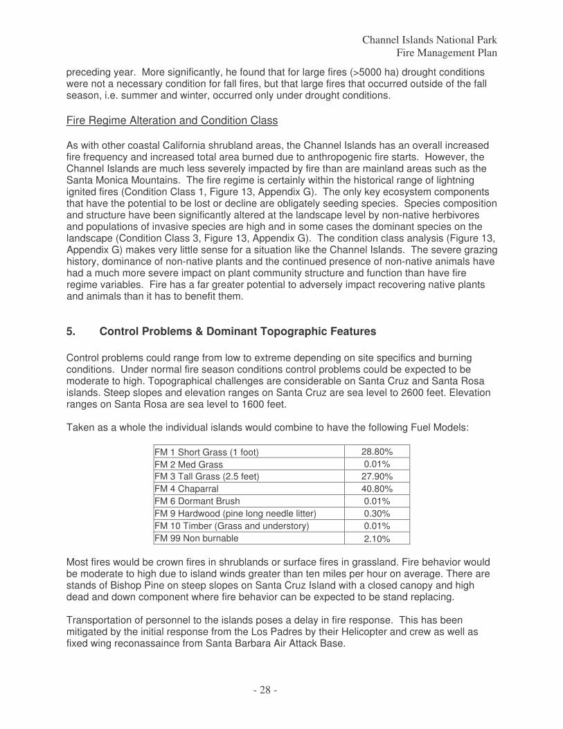
Channel Islands National Park Fire Management Plan
- 28 -
preceding year. More significantly, he found that for large fires (>5000 ha) drought conditions were not a necessary condition for fall fires, but that large fires that occurred outside of the fall season, i.e. summer and winter, occurred only under drought conditions. Fire Regime Alteration and Condition Class As with other coastal California shrubland areas, the Channel Islands has an overall increased fire frequency and increased total area burned due to anthropogenic fire starts. However, the Channel Islands are much less severely impacted by fire than are mainland areas such as the Santa Monica Mountains. The fire regime is certainly within the historical range of lightning ignited fires (Condition Class 1, Figure 13, Appendix G). The only key ecosystem components that have the potential to be lost or decline are obligately seeding species. Species composition and structure have been significantly altered at the landscape level by non-native herbivores and populations of invasive species are high and in some cases the dominant species on the landscape (Condition Class 3, Figure 13, Appendix G). The condition class analysis (Figure 13, Appendix G) makes very little sense for a situation like the Channel Islands. The severe grazing history, dominance of non-native plants and the continued presence of non-native animals have had a much more severe impact on plant community structure and function than have fire regime variables. Fire has a far greater potential to adversely impact recovering native plants and animals than it has to benefit them.
5. Control Problems & Dominant Topographic Features Control problems could range from low to extreme depending on site specifics and burning conditions. Under normal fire season conditions control problems could be expected to be moderate to high. Topographical challenges are considerable on Santa Cruz and Santa Rosa islands. Steep slopes and elevation ranges on Santa Cruz are sea level to 2600 feet. Elevation ranges on Santa Rosa are sea level to 1600 feet. Taken as a whole the individual islands would combine to have the following Fuel Models:
FM 1 Short Grass (1 foot) 28.80% FM 2 Med Grass 0.01% FM 3 Tall Grass (2.5 feet) 27.90% FM 4 Chaparral 40.80% FM 6 Dormant Brush 0.01% FM 9 Hardwood (pine long needle litter) 0.30% FM 10 Timber (Grass and understory) 0.01% FM 99 Non burnable 2.10%
Most fires would be crown fires in shrublands or surface fires in grassland. Fire behavior would be moderate to high due to island winds greater than ten miles per hour on average. There are stands of Bishop Pine on steep slopes on Santa Cruz Island with a closed canopy and high dead and down component where fire behavior can be expected to be stand replacing. Transportation of personnel to the islands poses a delay in fire response. This has been mitigated by the initial response from the Los Padres by their Helicopter and crew as well as fixed wing reconassaince from Santa Barbara Air Attack Base.
Channel Islands National Park Fire Management Plan
- 29 -
Travel by roads is slow, accessable by four wheel drive and smaller vehicles. During the initial stages of a wildfire on one of the islands the complexity may exceed the IAIC before a qualified IC would arrive on the island. This is mitigated by leaving the IAIC observing and relaying fire information to an IC enroute to the incident ICP.
6. Other Management Considerations Because the purpose of Channel Islands National Park is to preserve the nationally significant natural, scenic, wildlife, ecological, archeological, cultural, and scientific values of the Channel Islands..."., all wildland fire management actions will emphasize the preservation of the life, property, and natural & cultural resources. Fire prevention and control measures need to include the safety of fox pen captive breeding facilities; part of the endangered island fox program on Santa Cruz, Santa Rosa and San Miguel islands. The captive foxes are the primary insurance against a catastrophic event occurring in the wild fox population as well as a source of reintroduction stock to help augment the wild population. The wild population must also act as is an insurance against a catastrophic event for captive populations. During an incident the NPS Agency Representative is responsible for conveying fox pen information to the Incident Commander. Annual pre-fire season planning with the Los Padres National Forest by the Network FMO will include fire suppression briefing concerning fox pens, their locations and suppression strategies. Preventive measures should be adopted to reduce the probability that fires would impact foxes held in the captive breeding facility. In addition, fire response protocols should include the conservation of as many captive foxes as possible in the event a fire threatens the fox pen locations. Any site evaluations of the pens during an incident will be escorted by qualified fire personnel. Annual reduction of the fuel load will occur in and around the fox pens by creating a fire break around the outside of the perimeter fence and by reducing the fuel load inside the perimeter fence. Fox dens should be made of non burning material and appropriate for safe harbor in the event of a wildland fire. Due to times of the year when it may be inappropriate to conduct activities near the fox pens (late pregnancy through pup rearing period) it is safest to use power tools (weed trimmers) during the early growing season (November through mid-January) and manual removal February through May. Fuel reduction should be implemented again when noise can occur around the pens during July and August in preparation for the critical fire season. This work requires fire prevention measures and weather monitoring to ensure fire safe operations. The Central Valley compound is too large to remove all grass by hand, remove grass within 4 meters of the perimeter fence and within two meters of each pen. At the Navy site the pens are located on the top of a ridge; removal of grass should be conducted around each pen (4-meters strip width) as described above. During fuel reduction activities shovels and 5 gallon back pack pumps will be on site. Other considerations are the wildland urban intermix, numerous historic buildings and landscape plantings, as well as developing and maintaining good relations with assisting
Channel Islands National Park Fire Management Plan
- 30 -
agencies, cooperators, and Park neighbors. Section X addresses protection of sensitive resources on page 67. Fire management responsibility for US Navy, US Coast Guard and The Nature Conservancy lands inside NPS boundaries belongs to the Channel Islands National Park and falls within the cooperative agreement with the Los Padres NF.
IV. Wildland Fire Management Program Components
A. General Implementation Procedures Implementation of the components of the wildland fire management program at Channel Islands is consistent with the park’s fire management capabilities and will consider the current and predicted conditions affecting fire behavior. When possible, preplanned decisions based on historical fire behavior indices will be considered in Stage I Wildland Fire Implementation Plan development to select an appropriate management response. A Wildland Fire Situation Analysis (WFSA) will be initiated for all wildland fires that require an Incident Management Team. This plan will provide the framework for determining the appropriate management response. WFSA will be the responsibility of the Channel Islands Fire Committee with the Network Fire Management Officer.
B. Wildland Fire Suppression
1. Range of potential behavior The island weather in the summer can be generalized to have warm temperatures usually 60-80 degrees, high humidities averaging 70% and moderate wind speeds between 10 and 30 mph. Evening and morning fog layer gives the vegetation night time moisture recovery. Fuel conditions slow the rate of spread compared to the mainland but ocean winds from the northwest to northeast combined with alignment of slope allow the fire to spread more quickly than the fuel conditions would otherwise allow. The islands are also occasionally subject to dry Santa Ana winds from the east when fires could spread rapidly. Anacapa Island – three small islets about 700 acres – vegetation: Island Grassland, Coastal Sage and Chaparral. 45% of the island is typical of Fuel Model 2 and 45% correlates to Fuel Model 4. No fires have been reported on Anacapa but even a small fire could have a potentially significant impact on the seabird rookeries and cultural resources.
Santa Barbara totals approximately 650 acres, and is edged by vertical sea cliffs. The island is barren of trees and has only a few large shrubs. It has several small canyons that are biologically significant. 90% of the vegetation is Island Grassland characteristic of Fuel Model 1.
Santa Cruz Island supports approximately 36,000 acres or 55% chaparral species (i.e. Manzanita, Chamise), 26,000 acres, 40% tall grass, Fuel Model 3 and 400 acres of conifer forest.

Channel Islands National Park Fire Management Plan
- 31 -
Santa Rosa has approximately 54,000 acres of land. The interior is mountainous and covered with grassland, shrubs, and few trees. 30,000 acres, 60%, Fuel Model 1and 11,000 acres, 20%, Fuel Model 4 and 9000 acres, 15%, Fuel Model 3.
San Miguel covers approximately 10,000 acres. The island is generally a plateau with deeply eroded ravines. Since the removal of feral herbivores, vegetation (primarily grasses and shrubs) is again covering the island 3500 acres, 35%, Fuel Model 1 and 3500 acres, 35%, Fuel Model 4.
2. Preparedness actions Preparedness "refers to activities that lead to a safe, efficient, and cost-effective fire management program in support of land and resource management objectives through appropriate planning and coordination. Preparedness includes planned activities for the development and implementation of the wildland fire management program. These activities include staffing, training, fire prevention activities, education, provision and maintenance of support facilities, purchase of and contracting for equipment, supplies, support, planning and coordination, policy development and oversight, research, and interagency coordination." Departmental policy requires that all personnel engaged in wildland fire suppression and prescribed fire duties meet the standards set by the National Wildfire Coordinating Group (NWCG, PMS-310-1). Channel Islands will conform strictly to the requirements of the NPS wildland fire management qualification and certification system. Current training, safety and incident qualification requirements combined with the inability for island-going personnel to fulfill wildland fire resource orders make it difficult for CHIS park personnel to maintain red card qualifications. There are limited opportunities to have CHIS staff qualified as fire fighters at any level. Fire suppression is provided by the Network FMO and the fire suppression agreement with the Los Padres N.F. for initial attack. Militia positions such as resource advisors and technical specialists are readily supplied by the Park. Personnel with need to access the fire area will comply with incident qualifications outlined in PMS 310-1. The Network FMO will be responsible for obtaining the training required to meet Park needs for qualified wildland fire personnel. When advanced or specialized training is necessary, the Network FMO will work through the Regional Fire Management Officer to obtain funding and enrollment. The Network FMO will coordinate the Park's fire training needs with those of other nearby parks, cooperating agencies, and the region. Park wildland fire personnel will attend an annual wildland firefighter safety refresher and comply with Interagency Medical Standards for Qualification. Agreements with cooperators need to be addressed annually prior to fire season training. Fire equipment and cache items need to be maintained and inventoried prior to fire season training.
a. Fire Prevention, Education, and Community Assistance Channel Islands’ fire prevention and education program may be implemented in conjunction with other fire management and public safety agencies to increase awareness of fire prevention, develop understanding of the dangers and benefits of fire, protect human life and property, and prevent damage to cultural resources, occupied
Channel Islands National Park Fire Management Plan
- 32 -
structures, and natural resources. The program of public education regarding wildland fire prevention, potential fire benefits and dangers will be conducted as appropriate to help support Plan goals. Visitor contacts, bulletin board materials, handouts, and interpretive programs may be used to increase visitor and park neighbor awareness of fire hazards and benefits. The Area fire prevention and education specialist may provide assistance to the park for its fire prevention, education and community assistance programs. Park employees will be provided with information about fire prevention, the wildland/urban intermix, the objectives of the fire management program, and the dangers and benefits of prescribed fire and wildland fire. Employees will be kept informed about changes in the fire situation throughout the fire season. Park staff will work with the local cooperators and other agencies with fire management and public safety responsibilities to establish common protocols and procedures identify training needs, conduct joint training, and develop strategies for safer and more efficient fire management operations. A Park prevention plan wil be derived utilizing RAMS. This work will be accomplished with the Network FMO and FEIPS as well as input from the Channel Islands staff. b. Fire Danger A specific daily fire danger rating is not generated for the Park. The park will utilize the fire danger rating generated by the Los Padres National Forest. This rating can be obtained by phoning the Los Padres Communications Center at 805 938-9142 and at http://www.fs.fed.us/land/wfas/fdr_obs.dat, http://www.fs.fed.us/land/wfas/fd_class.gif Fire Danger Pocket Cards for the Los Padres are available to monitor trends and indicate fire danger comparison conditions. The PocketCard provides a description of seasonal changes in fire danger in a local area. The card communicates a common understanding of key index values provided by the National Fire Danger Rating System. Current Pocket Cards ar located at: http://famweb.nwcg.gov/pocketcards/southzon.htm. Los Padres announces morning and afternoon weather and the actual and predicted indices. c. Fire Weather Current fire weather information is available through the National Weather Service Forecast Office (Western Climate Center), The closest National Weather Service recording station is in Oxnard. Access to this information is available at http://www.wrh.noaa.gov/lox/. National Weather Service automated weather data for the islands can be found at: http://www.icess.ucsb.edu/resac/lws.html. Access to specific weather data covering western Ventura/Santa Barbara/ south Ca coast area can be found at: http://www.fs.fed.us/r5/fire/south/fwx/. Channel Islands has Remote Automated Weather Stations (RAWS) at Santa Barbara: CSBB, Santa Cruz: CSCI, and Santa Rosa: CSRI,
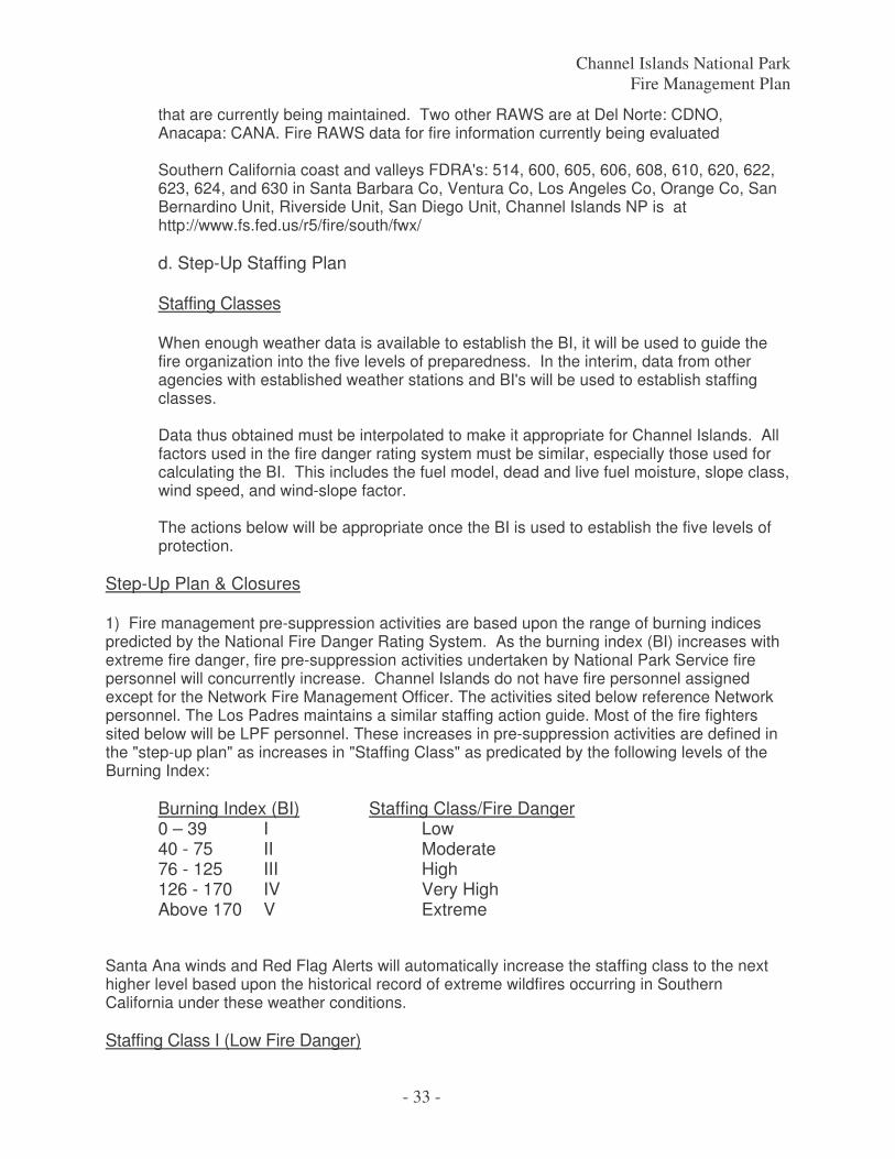
Channel Islands National Park Fire Management Plan
- 33 -
that are currently being maintained. Two other RAWS are at Del Norte: CDNO, Anacapa: CANA. Fire RAWS data for fire information currently being evaluated Southern California coast and valleys FDRA's: 514, 600, 605, 606, 608, 610, 620, 622, 623, 624, and 630 in Santa Barbara Co, Ventura Co, Los Angeles Co, Orange Co, San Bernardino Unit, Riverside Unit, San Diego Unit, Channel Islands NP is at http://www.fs.fed.us/r5/fire/south/fwx/ d. Step-Up Staffing Plan Staffing Classes When enough weather data is available to establish the BI, it will be used to guide the fire organization into the five levels of preparedness. In the interim, data from other agencies with established weather stations and BI's will be used to establish staffing classes. Data thus obtained must be interpolated to make it appropriate for Channel Islands. All factors used in the fire danger rating system must be similar, especially those used for calculating the BI. This includes the fuel model, dead and live fuel moisture, slope class, wind speed, and wind-slope factor. The actions below will be appropriate once the BI is used to establish the five levels of protection.
Step-Up Plan & Closures 1) Fire management pre-suppression activities are based upon the range of burning indices predicted by the National Fire Danger Rating System. As the burning index (BI) increases with extreme fire danger, fire pre-suppression activities undertaken by National Park Service fire personnel will concurrently increase. Channel Islands do not have fire personnel assigned except for the Network Fire Management Officer. The activities sited below reference Network personnel. The Los Padres maintains a similar staffing action guide. Most of the fire fighters sited below will be LPF personnel. These increases in pre-suppression activities are defined in the "step-up plan" as increases in "Staffing Class" as predicated by the following levels of the Burning Index: Burning Index (BI) Staffing Class/Fire Danger 0 – 39 I Low 40 - 75 II Moderate 76 - 125 III High 126 - 170 IV Very High Above 170 V Extreme Santa Ana winds and Red Flag Alerts will automatically increase the staffing class to the next higher level based upon the historical record of extreme wildfires occurring in Southern California under these weather conditions. Staffing Class I (Low Fire Danger)
Channel Islands National Park Fire Management Plan
- 34 -
Personnel will be on normal tours-of-duty. Supplies and equipment will be ready personnel will be assigned normal tours of duty and assigned to project work RAWS instruments will be serviced and/or stored away to prevent damage. All suppression equipment and gear will be serviced and maintained for immediate use. On duty Incident Qualified personnel will maintain one hour readiness during fire season. Staffing Class II (Moderate Fire Danger) Additional fire personnel are not required other than the parks normal daily complement of firefighters. Initial attack personnel will be assigned normal tours of duty and assigned to project work. Re-supply efforts will be completed and all equipment will be maintained and ready for use. Daily fire weather observations will be taken and entered into the National Fire Danger Rating System for computation of predicted fire danger (BI). Staffing Class III (High Fire Danger) A minimum of 10 firefighters, including one Incident Commander Type IV, will be available during working hours for initial attack. The individual fire fighters will be available, at their specific work location on the Los Padres ready for dispatch by air in during daylight hours Dispatch will have available schedules of all Incident Qualified personnel to minimize mobilization time. Where possible, island personnel will schedule staggered tours for 7 day coverage. Regular contact with local agencies will be initiated to monitor availability of resources for mutual aid mobilization. Predicted Lightning Activity Level of 5 or 6, dry lightning forecast or actual lightning occurring will raise the Staffing Class to IV. Staffing Class IV (Very High Fire Danger) A minimum of 10 firefighters, including one Incident Commander Type IV, will be available during working hours for initial attack. The individual fire fighters will be available, at their specific work location on the Los Padres ready for dispatch by air in during daylight hours. Regional Fire Management Officer will be contacted for accounting information and approval for starting an emergency pre-suppression account. Firepacks and equipment will be carried by PMS 310.1; IQCS qualified initial attack employees and be readily available at all times. Increase fire protection/detection patrols at key locations (i.e. visitor areas, work areas).
Channel Islands National Park Fire Management Plan
- 35 -
Dispatch will keep current information on resources availability, and qualified overhead in the event of an escaped fire situation, or out of park dispatch. 10 hour, 7 days a week coverage should be initiated when fire conditions meet the following criteria: 1) Fire activity is at Preparedness Level - IV and CHIS is at a high to extreme Fire Danger Rating (FDR). 2) CHIS is at a high to extreme FDR with 50% of the qualified fire fighters committed to out-of-park fires and our cooperators are at there respective draw down levels. The Fire Management Officer and/or alternate will maintain 7 day coverage. Aerial reconnaissance will be flown when conditions warrant. A record will be kept of staff whereabouts (on and off duty) to minimize mobilization time. Staffing Class V (Extreme Fire Danger) A minimum of 10 firefighters, including one Incident Commander Type IV, will be available during working hours for initial attack. The individual fire fighters will be available, at their specific work location on the Los Padres ready for dispatch by air in during daylight hours All divisions will be notified of possible dispatch of red carded personnel. Dispatch will keep informed of daily resource availability (NPS, USFS, County). Lieu days, leave, and training may be canceled for all staff. Additional fire protection/detection patrols of visitor use areas will be initiated. Aerial reconnaissance may be flown on a regular basis. Consideration will be made to bring in outside fire crews during multiple wildland fires. In addition to those actions and activities to be accomplished during Staffing Class IV, public-use area closures or other public-use restrictions will be considered and implemented on a case-by-case basis by the Chief Park Ranger or his/her acting designee. Additional payments for extended coverage and tours of duty will be charged to emergency pre-suppression funds.
3. Pre-Attack Plan A pre-attack plan is a comprehensive compilation of essential fire management information made available in the fire management or dispatch offices for use by an incident team. The Plan includes locations of incident concerns such as water sources, structures, helispots, flight routes, fuel breaks, roads, trails natural barriers and camp locations. The Plan has evaluations of structures and improvements, sensitive natural and cultural resources to ensure their value is considered during fire management operations. Also included would be criteria for evacuations and closures, structure protection needs, agreements, and maps The pre-attack strategy for Channel Islands will utilize initial attack as an aggressive suppression action consistent with firefighter and public safety and values to be protected. Confine, contain and control tactics will be employed. Firefighting with handtools, pumps and
Channel Islands National Park Fire Management Plan
- 36 -
aircraft utilizing existing roads and trails to construct wetline and handline or fire out are expected control actions. MIST tactics will be utilized. Limited heavy equipment is available on Santa Rosa Island. A resource advisor must be present during its use. Communication to the Park Dispatch Center will take place to initiate a wildland response by Park and Cooperator personnel. Initial attack action by qualified personnel should be used while resources are dispatched. Park vehicles should be equipped with firefighting personal protective equipment, tools and filled backpack pump. Fire hoses and extinguishers should be available at Park structures, maintained and tested annually.
4. Initial Attack Fire Detection The park will rely heavily on island personnel for fire detection. Information will be relayed to the Channel Islands Dispatch Center to report the incident to the Park Superintendent, Chief Ranger and Fire Management Officer. During very high and extreme fire danger episodes tours may be extended and lookouts stationed at key locations to broaden coverage. Transportation to and from the islands is conducted on a routine schedule by air and boat. Observation while in route will aid in detection. During regularly scheduled flights management may authorize deviation of flight patterns to supplement detection methods. When conditions warrant, the Park may use aerial detection by outside agencies. This may include USFS, Navy, and/or private organizations. This could include both fixed wing aircraft and helicopters. Fire Response All wildland fires will be suppressed with an appropriate response. Generally, all suppression activities on federal lands will be managed in Unified Command with a primary cooperator according to jurisdiction. Channel Islands Dispatch Center or Duty Officer will report an incident to the Los Padres Emergency Operations Center (EOC). The Los Padres EOC is responsible for contacting their appropriate fire management or law enforcement personnel to respond to the report of a wildland fire. The Los Padres will be the single ordering point for fire resource needs. The EOC will require an island point of contact. Incident communications will be established on Los Padres frequencies. The Interagency Agreement between the Los Padres and Channel Islands including the communications plan is in Appendix E. The Channel Islands Dispatch or Duty Officer will ensure notification of an incident will be made to the Channel Island’s Fire Management Officer (Network FMO), Chief Ranger, Superintendent, Public Information Officer, Natural Resource Officer, Cultural Resource Officer, Aviation Manager, and any cooperator of the incident island. The Fire Management Officer or Chief Ranger or designated qualified Agency Representative responds to the Incident Command Post, initially operating from the Santa Barbara Air Attack Base in Goleta, and serves as the Unified Incident Commander, Agency Representative or Resource Advisor. A qualified Resource Advisor will be requested to proceed to all fires on the Channel Islands or to fires that have potential to spread on these lands. The Resource Advisor will assist in identifying sensitive resources and provide input on appropriate actions to minimize the impacts to these resources. The National Park Service Incident Commander or Agency
Channel Islands National Park Fire Management Plan
- 37 -
Representative is responsible for requesting a Resource Advisor though the Los Padres EOC. Size Up/Initial Attack Initial Attack (IA) Wildland fires must receive appropriate initial attack action by the nearest available suppression forces. The reporting party should maintain visual contact with wildfire conditions from a safe location to provide periodic fire condition updates until suppression resources arrive on scene. Park personnel should evacuate personnel and visitors to a safe location away from expected fire behavior. Generally first on scene will be NPS personnel, most often the Island Ranger. The Initial Attack Incident Commander (IAIC) will be the first qualified unit to be able to manage the fire; Incident Commander (IC) Type 5, 4, or 3. Actions taken will be in the scope of qualifications of initial response personnel. This may require continued visual updates.of the incident until more personnel arrive on scene. The IC will size up the fire and inform the fire dispatcher of the size of the fire, rate of spread, types of fuels, weather conditions, hazards, fire potential, any immediate potential for damage to cultural resources or NPS facilities and the resource needs for suppression. Dispatch will then report the incident to the Los Padres EOC. As safety allows, IAIC will assess the complexity of the fire utilizing the Channel Islands Complexity Guide (Appendix E) to determine their capacity to manage the incident. If the IAIC is unable to initiate action due to the management complexity, forces will be staged in a safe location or modified tactics will be utilized until a fully qualified Type 3 Incident Commander arrives on scene. Cooperating fire agencies may provide qualified personnel in the role of IC until qualified personnel from the park arrive on scene and assume the role of IC or Unified Command IC for fires on federal lands. If the fire exceeds the qualifications of the current IAIC he/she will be relieved by the Network Fire Management Officer. The Fire Management Officer (or qualified designate) will make all strategic and tactical decisions, and will rely on the observations and current situation reported by the IAIC. Due to the minimal fire staffing of the park immediate resources will be dispatched per the Agreement with the Los Padres National Forest. A Transition will take place to determine the complexity of the incident and qualified Incident Commander will assume command. Channel Islands will provide a qualified Incident Commander and or Agency Representative and a qualified Resource Advisor to the incident. Because of the difficult logistics of mobilizing any needed fire suppression resources to all five of our management units, initial attack strategies are for aggressive control of the fire. Protection of human life receives the highest priority in regard to any suppression action. The measures currently being taken Initial Attack
a. Priority setting during multiple fire occurrences
1. Protection of life 2. Protecting Island fox captive breeding facilities 3. Protecting historic ranch and light station complexes 4. Protecting other Park facilities 5. Protecting habitat for federally listed plants 6. Protecting isolated historic structures
Channel Islands National Park Fire Management Plan
- 38 -
7. Protect vegetative cover 8. Other natural or cultural resources
b. Criteria for appropriate initial attack response consistent with GMP/RMP objectives
Public and firefighter safety. Protection of cultural, historic, and natural resources. Protection of improvements and private property. Minimum fire-line construction and use of Minimum Impact Suppression Tactics (MIST). Available suppression resources and response times. Fire behavior as determined by fuels, weather, and topography. Use aircraft and mechanized equipment as necessary and approved by park Superintendent to support above-listed criteria.
c. Confinement as a Strategy
Confinement may be used to minimize resource damage and to provide for firefighter safety. A confinement strategy may be selected for initial attack as long as it is not being used solely to meet resource management objectives. Resource benefits may be a by-product, but the strategy must be based upon the criteria listed above. A confinement strategy may also be selected in the WFSA process when initial attack has failed to contain a wildland fire. This strategy may also be used to minimize resource damage and to provide for firefighter safety.
d. Response Times Response time for initial attack ground resources is approximately one hour or more depending on proximity, accessibility, mainland fire activity, and other variables. Initial attack personnel dispatched by the Los Padres will take from one to two hours to arrive on scene. Extended attack resources should be able to respond in two to six hours or more, again depending on proximity and availability.
e. Restrictions and Special Concerns
The constraints on these strategies affect the manner in which the wildland fire will be suppressed, or the prescribed fire will be managed.
Channel Islands National Park Fire Management Plan
- 39 -
Fire retardant can stain or corrode historic structures and will not be used in the vicinity of these structures. If wooden structure protection is necessary, Class “A” foams may be used. Any fire suppression activity in the vicinity of a known historic site will receive guidance from a designated representative from the Park. Water resources are scarce on the islands but ocean water is obviously abundant. Use of helicopter water drops is anticipated as a primary fire suppression tool. Helicopters with buckets instead of fixed tanks are recommended in ordering resources. The Los Padres helicopters are equipped with buckets. Fixed tank helicopters need notice of salt water conditions.
f. Local Issues
Channel Islands utilize the Los Padres National Forest for initial and extended attack within the NPS boundary as well as adjacent properties on the islands. This alliance requires that Channel Islands work closely with these agencies in planning, training, preparedness, and other fire management issues.
5. Extended Attack and Large Fire Suppression a. Extended Attack. Extended attack occurs when a fire has not been contained or controlled by initial attack forces and continues into the next operational period. At a minimum, a qualified Type 3 IC will respond to all extended attack incidents to assure adequate oversight of federal firefighting resources. Qualified IC’s from cooperating agencies can fill this role until federal oversight can be provided. A transition to a higher level incident management team may be necessary as the incident grows in complexity. The Channel Islands Fire Transition Checklist, will be used to assist in making a transition determination. A Delegation of Authority will be prepared for all incidents involving federal lands which transition to a type I or II Incident Management Team. Suppression of fires will be aggressive and will be conducted with the highest regard for human safety. Furthermore, all control efforts will be evaluated for consideration of effects on resource values. Fire control activities will follow the Incident Command System process and will use standard suppression practices. Any fire suppression strategy will first take into consideration human life and safety, then private property, natural and cultural resources. Fire suppression methods used should be those which cause minimum resource damage while accomplishing effective control. The January 2001 Review and Update of the 1995 Federal Wildland Fire Management Policy recommended that federal “guiding principles” should include several key elements. Highlighted in the review is that firefighter and public safety is the first priority, and that fire management plans, programs, and activities should support land and resource management plans and their implementation. Additionally, fire management plans and activities should be based on the best available science, and fire management programs and activities are economically viable, based on values to be protected, costs, and land and resource management objectives. The appropriate management response to an incident will consider a
Channel Islands National Park Fire Management Plan
- 40 -
full range of alternatives. Incident Commanders should consider all available tactical options, but choose the suppression option with the least potential environmental impacts, as long as firefighter and public safety is not compromised. Tactical options that should be considered include:
• Use natural barriers as fireline, where feasible • Use cold trail, wet line, or a combination • Utilize roads and trails as fireline • Avoid riparian areas and other sensitive habitats • Use low impact tools
Suppression activities will avoid disturbance of all T&E species and their habitats, as well as archeological and cultural sites, whenever reasonably possible. A qualified National Park Service representative will be present at the Incident Command Post (ICP) during all extended attack suppression incidents. Maps of sensitive natural and cultural resources will be available to representatives prior to any suppression incidents. b. Implementation plan requirements – Wildland Fire Situation Analysis (WFSA) development: When a fire escapes initial attack, a new strategy must be developed to suppress the fire. This selection process is accomplished through the development of a WFSA. The WFSA is a decision process that employs a systematic and reasonable approach to determine the most appropriate management strategy for a particular situation. Reasonable management alternatives are identified, analyzed, and evaluated, and are consistent with the expected probability of success /consequences of failure. The Superintendent shall approve the WFSA and any revisions. Evaluation criteria include firefighter safety, anticipated costs, resource impacts, and social, political, and environmental considerations. The evaluation of alternatives becomes the triggering mechanism for re-evaluation of the WFSA. An electronic version of a WFSA can be found at the U. S. Forest Service website at http://www.fs.fed.us/fire/wfsa/. c. Incident Management Transition: Transition to an incident management team requires a briefing by the Superintendent and a limited delegation of authority for the suppression of the fire(s). The briefing should address agency specific concerns, priorities, firefighter and public safety, economic and resource concerns, and other topics or issues of importance and relevance to the suppression effort.
6. Minimum Impact Suppression Tactics The goal of MIST is to minimize fire suppression impacts on the land while ensuring the actions taken are safe, timely and effective. Strategies for suppression activities and tactical operations will be planned to have the least long-term impact to the resource. All fire management activities within the Chanel Islands should adhere to MIST where possible.

Channel Islands National Park Fire Management Plan
- 41 -
• All fire management activities in Channel Islands will rely on tactics, which do a minimum amount of resource damage while maintaining the safety of firefighters, personnel, and the public as the highest priority. • Fireline construction will be minimized by taking advantage of natural barriers, rock outcrops, trails, roads, streams, and other existing fuel breaks. • Limbing along the fireline will be done only as essential for the suppression effort and for safety. • Unburned material may be left within the final line. • Clearing and scraping will be minimized. • Snags or trees will be felled only when essential for control of the fire or for safety of personnel.
7. Rehabilitation Guidelines When a suppression action is taken, rehabilitation may be necessary. The most effective rehabilitation measure is prevention of impacts through careful planning. Every effort should be made to prevent excessive human-caused impacts during a suppression effort through careful planning and supervision, individual education and commitment, and the use of minimum impact suppression techniques. When suppression rehabilitation is necessary, efforts will be initiated by the Incident Commander while the fire is being suppressed through mop-up with guidance from the AREP, READ or designated individual from the Park. Rehabilitation will be directed toward minimizing or eliminating the effects of the suppression effort and reducing the potential damage and hazards caused by the fire. These actions may include:
• Construct waterbars to prevent erosion. • Place “boneyards” of cut vegetation in a natural or random arrangement. • Position cut ends of logs so as to be inconspicuous to visitors and camouflage where
possible. • Flush cut stumps, camouflage with soil and moss. • Restoration of natural ground contours. • Remove handline berms.
If re-vegetation or seeding is necessary, only island-specific native plant species will be utilized, and the Natural Resource Specialist/ Park Botanist will be consulted for approval of the species chosen. Rehabilitation efforts should be initiated as soon as they can be safely implemented, which may be before the fire is declared controlled. If extensive emergency stabilization is needed or if rehabilitation is needed to reduce the effects of a wildland fire then the Park can request appropriate funding through the Burned Area Emergency Response (BAER) fund. The BAER fund is administered through the NPS Branch of Fire and Aviation Management at the National Interagency Fire Center. The specifics of the policy can be found in 620 DM 3 DOI BAER Policy (2004). BAER project requests totaling $500,000 or less can be approved by the Regional BAER Coordinator. Submissions over this amount are reviewed at the regional level, and forwarded to the Fire Management Program

Channel Islands National Park Fire Management Plan
- 42 -
Center for approval. BAER plans must be submitted to the regional office within seven (7) calendar days following containment of a wildfire (RM18 1999). 8. Records and Reports The Fire Management Officer is responsible for all fire related records and reports except the WFIP. This responsibility may be delegated to an incoming Incident Commander for any fire escaping initial attack. Permanent Park Records. The following will be held as permanent historic resource records:
• Fire reports (DI-1202, WFIM, supplementary reports, ICS forms). • Fire weather records. • Historic records of the park, including photos or maps showing vegetative cover, etc. • Monthly reports or other records which document fire occurrence or behavior. • Maps or records pertinent to fire management. Situation Reports. Situation reports contain current information about fire danger, fire status, and resource availability. Parks prepare situation reports during the fire season or when (1) fire danger is very high or extreme, (2) when a fire has occurred or is in progress, (3) or when required. The Network FMO or Fire Program Management Assistant (FPMA) prepares and transmits situation reports via the Shared Access Computer System (SACS) and Wildland Fire Incident Management (WFIM). Since situation reports are used in the FirePro/FPA needs analysis, it is important that daily entries be made for all fires. Fire Report Records. Each fire of significance (five acres or greater) on Channel Islands will be reported immediately to the Superintendent by name, location and size. An ICS-209 report will be accomplished twice daily for extended fire situations. A DI-1202 will be completed for all fires. The fire reporting process is a critical element within the FirePro/FPA analysis and must accurately reflect the fire load of the Mediterranean Coast Network and FPU 10. The IC will maintain a complete accountability of fire costs for each fire. A qualified cause and origin fire investigator will investigate all wildland fires on the Channel Islands. Any investigations involving potential claims against the government, trespass fires, or other illegal activities on federal lands will be immediately turned over to the Law Enforcement Branch of the Resource Protection Division. Completion of the Individual Fire Reports is the responsibility of the ranking National Park Service employee on scene of the wildland fire. These reports will be submitted to the Fire Management Officer within 48 hours after the fire is declared out. Within 10 days individual fire reports will be entered into SACS/WFIM. An NWCG qualified fire investigator will be assigned to fires where a responsible party can be identified. A Case/Incident Record (Form 10-343) will be completed, with attachments, to document the fire activities. A case report is required when a potential suspect can be identified, if a claim for recovery of suppression costs may occur, or when resource damage has occurred to federal property.
Channel Islands National Park Fire Management Plan
- 43 -
C. Wildland Fire Use Wildland fire use will not be used as a management tool at Channel Islands. This option was rejected due to the low natural frequency of fire, the presence of ungulates on Santa Rosa and Santa Cruz Islands, the presence of non-native invasive plants that are facilitated by fire, and the ongoing recovery of vegetation from grazing.
D. Prescribed Fire Though a program of using prescribed fire at Channel Islands is not considered in this Plan, individual burns may be used for protection of cultural resources, especially hazard fuel reduction, and natural resource objectives. If a determination is made that a specific prescribed fire is required, that prescribed fire will be subject to the requirements of NEPA, the NHPA and other applicable regulations. All prescribed fire operations will adhere to NPS prescribed fire policies and procedures found in RM-18. The park completed an Environmental Impact Statement for Santa Cruz Island Restoration (2002). This plan includes use of fire to control non-native fennel. The fire portion of the plan has not been implemented.
1. Planning and Documentation a. An approved burn plan will identify needed resources, individual responsibilities, and
timelines. These activities include scheduling of resources, coordination with neighboring agencies and communities, and obtaining necessary permits.
b. Long-Term Prescribed Fire Strategy
1. The purpose of prescribed burning at Channel Islands would be to manage
vegetation (specifically invasive plant species), and reduce fuel loading. Prescribed fire objectives will be to manage vegetation to reduce hazardous fuel loads, promote or enhance the growth of native vegetation and control of non-native plant species.
2. Needed Personnel Channel Islands do not have sufficient personnel trained to manage a prescribed fire. Personnel needed for a specific burn will be identified in the projects burn plan and be from the NPS and USFS or other cooperating agency if PMS 310.1 and IQCS qualified.
3. Fire Weather, Effects, and Behavior Monitoring The primary purposes of fire monitoring are: • To ensure that any fire management activities that the Channel Islands proposes and
implements are meeting management objectives. • To provide guidance for future prescribed burning implementation. • To ensure that the park collects at least the minimum information necessary to evaluate the
CHIS fire management program (Fire Monitoring Handbook 2001).
Channel Islands National Park Fire Management Plan
- 44 -
The benefits to establishing standardized data collection procedures in a fire monitoring program include documenting basic information, detecting trends, identifying future research needs, and facilitating information exchange between resource protection staff and fire suppression agencies. The fire monitoring program will be in accordance with the National Park Service Fire Ecology Assessment Tools (FEAT) and Inventory and Monitoring standards as they apply to the needs of the Channel Islands. Monitoring of prescribed fires at Channel Islands is intended to provide information for quantifying and predicting fire behavior and its ecological effects on Park resources while building an historical record. Monitoring measures the parameters common to all fires: fuels, topography, weather, and fire behavior. In addition, ecological changes such as species composition and structural changes will be monitored for several years after a fire. This information will be very useful in adjusting the prescribed fire program to better meet short and long-term resource objectives. Point Reyes National Seashore is the host park for the Fire Effects Monitoring Crew associated with Channel Islands. The crew can visit the park to read established plots on a schedule defined in the Fire Monitoring Handbook. This schedule requires the plots to be monitored one, two, five and ten years after a prescribed fire treatment. The Network Fire Ecologist at the park is the point-of-contact for the crew and maintains the data associated with these monitoring plots. It is anticipated that a very little shrubland acreage within the park will be burned with prescribed fire, while there is the potential to burn accumulations of non native vegetation for the purpose of altering fire behavior and to control non-native plant species. The park should be prepared to monitor any sensitive plant populations that experience wildfire in order to develop basic information on fire effects in these species. During prescribed burning, monitoring will include mapping, weather, site and fuel measurements, and direct observation of fire characteristics such as flame length, rate of spread, and fire intensity. Operational monitoring provides a check to insure that the fire remains in prescription, and serves as a basis for evaluation and comparison of management actions in response to measured, changing fire conditions, and changes such as fuel conditions and species composition. All prescribed fires will be monitored regardless of size. The Network Fire Management Officer will establish specific fire information guidelines for each fire to update intelligence about the fire. The Network Fire Management Officer will assure that assigned qualified personnel are used to monitor the behavior of prescribed fires. By being able to assess fire’s potential, characterize and quantify its effects, and determine if it is within prescription, an efficient and flexible monitoring program will result.
4. Prescribed Fire Project Critique A Fire Management Committee, identified in Section V, A. page 55, will critique each prescribed fire. A report detailing the actual burn will accompany any recommendations or changes deemed necessary in the program. This report will be submitted to the Superintendent. A critique of the fire management program, including the prescribed fire program, will be held by the Fire Management Committee each year prescribed burns are conducted at the conclusion of
Channel Islands National Park Fire Management Plan
- 45 -
the fall fire season.
5. Reporting and Documentation Requirements All prescribed fire forms will be completed as outlined by the Network Fire Management Officer. A fire monitor will be assigned to collect all predetermined information and complete all necessary forms prior to, during, and after the fire. All records will be archived in Channel Islands' fire records for future use and reference. The Network Fire Management Officer will prepare a final report on the prescribed fire. Information will include a narrative of the fire operation, a determination of whether objectives were met, weather and fire behavior data, map of the burn area, photographs of the burn, number of work hours, and final cost of the burn. The forms necessary for documenting prescribed fire activities are outlined in RM-18. The Individual Fire Report, DI-1202, and the Incident Record, and entry into WFIM are the responsibility of the Network Fire Management Officer and documents all personnel and equipment costs involved in the burn.
6. Historic Fuel Treatment Map A series of prescribed burns were conducted between 1993 and 1999 by NPS and TNC personnel. Projects were generally intended to reduce fuel loading, to enhance regeneration of historic native vegetation types, or to reduce cover by exotic plant species. Some of the burns included monitoring plots intended to document fire effects on vegetation. The total area treated by all projects was 7251 acres (2934 hectares). The two Central Valley burns (1998) were followed up by herbicide applications, intended to eradicate dense stands of exotic fennel (Foeniculum vulgaris). Areas burned in the Poso (1993), Alegria (1994) Sauces (1995), Johnson’s (1996) burns were burned again in the Christy burn (1999). These projects were discontinued when Lyndal Laughrin, University of California Santa Cruz Island Reserve manager, determined that the potential vegetation of the sites was probably various shrub types, not grasslands as previously assumed, and that historic shrub vegetation types were not being encouraged by repeated short interval fires.
Channel Islands National Park Fire Management Plan
- 46 -
7. Local Prescribed Burn Plan Requirements Channel Islands would consider use of prescribed fire as a means to control hazardous fuels and non-native plant species, provided that adequate research has been conducted to understand the response of treated areas to fire. These prescribed fires will be subject to the requirements of NEPA, the NHPA and other applicable regulations. Prescribed burning on the Channel Islands is subject to written approval of a Smoke Management Plan from the Santa Barbara County Air Pollution Control Board (APCD). Park prescribed fire burn plans identify preplanned requirements (prescriptions) for initiating and continuing prescribed burn ignitions and operations. These prescriptions include:
• Minimum number of fire crew • Specific skill certification requirements for the fire crew • Other fire-related staff requirements • Range of possible ignition dates • Pre-ignition site preparation requirements • Equipment needed on-site
Channel Islands National Park Fire Management Plan
- 47 -
• Fuel model(s) used • Acceptable temperature, humidity, wind direction, wind speed, and fuel moisture ranges • Predicted fire behavior
8. Exceeding Prescribed Fire Burn Plan If the prescribed fire escapes the burn unit and immediate efforts at control are not successful, it will be declared a wildland fire and suppressed. A Wildland Fire Situation Analysis (WFSA) will be completed and additional personnel and resources ordered as determined by the Incident Commander. If the fire continues to burn out of control, additional resources will be ordered through the Los Padres Communication Center (LPF Dispatch) who will respond to the incident according to the Memorandum of Agreement to supply initial and extended attack resources including appropriate complexity level overhead personnel. Notification will be made to the Park Dispatch to contact the Park Superintendent, Chief Ranger and Network Fire Management Officer. An incident management team or other non-local resources may be requested to assume command of the fire.
9. Air Quality and Smoke Management
a. Air Quality Issues: The Channel Islands are located in a Class II air quality area. The Fire Management Plan will be in compliance with the Clean Air Act. The objectives for smoke management and compliance with the Clean Air Act are similar to those for fire management: to encourage a natural process so long as it does not endanger public health and safety. Smoke levels become unacceptable when they impair visibility to such a degree that they detract from visitor enjoyment of the primary Park resource with emphasis on the vistas of Channel Islands. Dense smoke within Channel Islands is generally unacceptable; however, it may be tolerated for short periods if the winds assure good mixing. Channel Islands will also evaluate the forecasted impact of smoke on local communities and visitor safety. Smoke impact to developed areas due to prescribed fire from the Channel Islands is expected to be nearly absent due to the Park’s remote location 15-40 nautical miles offshore. The prevailing winds NW-NE averaging 8-20 miles per hour and average mixing height above 1000’ at time of a burn. Channel Islands will work closely with the Santa Barbara County and Ventura County Air Districts.
It may be necessary to aggressively control fires when smoke affects a sensitive area or creates a significant public response. All fire activities may have to be curtailed when an extended inversion or air pollution episode is in effect. Traffic control measures will be undertaken in conjunction with local law enforcement personnel when such episodes occur. Complaints regarding smoke will be documented and communicated to the Superintendent.
b. Smoke Mitigation:
Channel Islands National Park Fire Management Plan
- 48 -
Channel Islands will notify the surrounding assisting agencies, at the time of any fire ignition. Thereafter, smoke characteristics will be evaluated regularly. A process will be developed for implementation to determine if adverse impacts to air quality and visibility are occurring from management decisions.
To minimize the effects of smoke the following guidelines will be considered when planning a prescribed fire:
Burning will be conducted only when visibility exceeds 5 miles or when the fire weather forecast indicates the presence of an unstable airmass, afternoon mixing heights are 500 meters or greater, and ventilation rates (mixing height in meters X transport wind speed in meters per second) is 1500 or greater.
10. Debris Burning Fire is occasionally used to dispose of natural vegetative debris deemed infeasible or impractical to remove mechanically in a wildland fuel environment. In the past, burnable debris generated by the Park has been pile burned on site due to prohibitive costs associated with any method of removing debris from the island. The debris may be generated from routine maintenance activities, resource management activities, piled debris generated from construction activities, removal of hazard trees, discarded building and administrative materials. Any material being burned for debris disposal must be classified as permissible to burn under applicable Federal, State, Tribal, and Local regulations. Debris burned in non-wildland environments does not require a prescribed burn plan. Debris burned in a wildland environment, including traditionally established burn pits on-island, requires a prescribed fire plan. The Park follows all applicable guidance and regulation when using fire for debris disposal. Parameters for debris burning are:
• Temperature: Less than or equal to normal average high temperature for the month.
• Wind Speed: Less than 15 mph.
• Relative Humidity: Greater than 40%.
• Fine Fuel Moisture: Surrounding fuels greater than 12%.
• Smoke Dispersal: Mixing heights equal to or greater than 1000 feet.
E. Non-Fire Fuel Treatment Applications
1. Mechanical treatments
a. Annual Activities
Channel Islands National Park Fire Management Plan
- 49 -
Hazard fuels at Channel Islands are typically managed through mowing (grasses and other herbaceous vegetation), raking, cutting and chipping (woody vegetation), or other mechanical or cultural means.
Fuels around buildings, boundaries, roads, trails, picnic areas and other sites occasionally accumulate sufficient fuel density to create a hazard to, Park facilities, historic resources, or human health and safety. These fuels are usually managed by mechanical removal. These fuels are removed from these areas at least twice annually.
Fuels reduction is maintained around most structures in the Park. These treatments are typically re-mowed every two to four weeks during the growing season depending on the importance of the resource, the amount of visitation in the area, and the availability of staff and equipment.
Heavy equipment including industrial mowers, large trucks, and trailer-mounted wood chippers are often used in mechanical fuel removal. Heavy equipment except mowers should usually be confined to existing roads and trails. In all cases, tracked and wheeled vehicles should only be used off roads and on trails under conditions where they will not significantly disturb soils, compact soils, or break up vegetative cover, and must be approved by the Park Management Team.
b. Required Monitoring Monitoring will be done to determine if the project objectives were met. This monitoring may be through the use of photo plots, vegetation transects, or a visual assessment. c. Critique Format Accomplishment of objectives, methodology, cost effectiveness, safety issues, and resource damage are some of the topics to be discussed. d. Funding and Cost Accounting FIREPRO/NFPORS funding requests for individual projects may be submitted to the Regional Fire Management Officer by the Network FMO. Documentation of individual project costs will be submitted to the Regional Fire Management Officer for review. Expenditures will not exceed the authorized project amount. e. Reporting and Documentation All project forms will be completed as outlined by the Network Fire Management Officer. All records will be archived with the Park's fire records for future use and reference. A completion report will be forwarded to the Regional Fire Management Officer. The network Fire Management Officer is responsible for preparing a final report on each project. Information will include a narrative of the project operation, a determination of whether objectives were met, map of the area, photographs of the site, number of work hours, and final cost of the project.
Channel Islands National Park Fire Management Plan
- 50 -
f. Annual Planned Project List Proposed projects may be submitted to the Network Fire Management Officer by any division chief. The Network Fire Management Officer will compile a list of these projects and submit them to the Superintendent for approval and prioritization.
F. Emergency Rehabilitation and Restoration On May 20, 2004, the Department of the Interior issued new policy on burned area emergency stabilization and rehabilitation. The specifics of the policy can be found in 620 DM 3 DOI BAER Policy (2004). The Network Fire Management Officer and the Natural Resource Specialist, subject to review by the Park Fire Committee, will jointly formulate a rehabilitation plan for each fire. The BAER plan will be submitted to the Regional BAER Coordinator through the Network Fire Management Officer for approval within 7 days of the time the fire is contained. BAER project requests totaling $500,000 or less can be approved by the Regional BAER Coordinator. Submissions over this amount are reviewed at the regional level and forwarded to the NPS Fire Management Program Center for approval.
V. ORGANIZATIONAL AND BUDGETARY PARAMETERS
A. Organizational Structure of the Fire Management Program This section discusses areas of responsibility for implementation of the fire management program by specific Park position. There may be instances that the same person functions in two areas of responsibility. The purpose of this section is to clearly define areas of responsibility, provide clear direction and accountability, and further the development of a responsive fire management program.
1. Superintendent
Fire management at Channel Islands is the responsibility of the Superintendent, with technical duties and accompanying responsibilities delegated to staff members. The Superintendent will be responsible for management of the program within Departmental and National Park Service policy, Director’s Order 18; Wildland Fire Management (DO-18), and all relevant laws and regulations.
a. Ensures that a comprehensive fire management program is adequately planned, staffed, implemented, and that the Fire Management Plan is reviewed annually and revised as necessary.
b. Maintains and facilitates public and media relations pertaining to both suppression and
prescribed fire.
c. Approves prescribed fire plans and Smoke Management Plans.
Channel Islands National Park Fire Management Plan
- 51 -
2. Acting Superintendent Is delegated all decision making responsibility when the Superintendent is absent from the Park.
3. Division of Natural Resources
The Chief, Natural Resources Management will have a major role in fire management planning. They will be involved in monitoring fires, both during and after suppression activities, and will obtain the database needed for fire planning. They can be called upon as a Resource Advisor during all suppression actions.
a. Coordinates fire research efforts, and serves as the primary resource advisor for project fires or prescribed fires.
b. Manages the Weather Information Management System (WIMS) and RAWS data.
c. Serves as a member of the Fire Management Committee.
d. Develops natural resource objectives for prescribed fire.
e. Plans and coordinates prescribed fires and non-fire hazard fuels and wildland/urban intermix treatment projects.
f. Recommends personnel in the Division that can train in and act in a resource or
technical advisory role on incidents.
4. Division of Cultural Resources Cultural Resources Management will have a major role in fire management planning. They will obtain the database needed for fire planning and be involved in recommending appropriate action for archeological and historic properties on the islands both during and after suppression activities. They can be called upon as Resource Advisors during all suppression actions. They will develop cultural resources objectives for prescribed fire.
5. Division of Resource and Visitor Protection The Chief Ranger has overall responsibility to ensure that the park's fire management program is implemented by the Fire Management Officer, and the fire management team. The Chief Ranger acts as the Alternate Park Fire Management Officer and is a member of the Park Fire Committee, reviews the Wildland Fire Situation Analysis (WFSA) prior to signing by the Superintendent or Chief of Operations. Approves assistance to other parks, regions, or agencies, and oversees management of the park's communications center. The Park Island Rangers are responsible for the initial action and assessment of the fire. They will act as Incident Commander within their incident qualifications until released. They are responsible for maintaining island fire caches and initiate any resupply needs. They are responsible for
Channel Islands National Park Fire Management Plan
- 52 -
managing the manual weather stations and cooperate in the maintenance of RAWS on their island.
6. Network Fire Management Officer
a. Responsible for all aspects of the Park fire and fuels management program planning, including implementation and execution.
b. Responsible for maintaining liaison and coordination with Network, Region,
interagency community and other Divisions in all matters relating to the Park fire management program.
c. Responsible for managing the Park’s use of the National Fire Danger Rating
System, the NPS Wildland Fire Computer System (SACS) and WFIM and WIMS, the resource ordering system (ROSS), the Incident Qualification and Certification System (IQCS), Fire Program Analysis (FPA), and FIREPRO/NFPORS budgeting.
d. Responsible for Park’s wildland fire qualification and certification program, fire
monitoring, fire training and mobilizations, development of preparedness, suppression, wildland/urban interface, fuels management and prescribed fire operational plans, development of cooperative agreements with local and state agencies, and administration of Rural Fire Assistance Program grants to local fire departments.
e. Responsible for overall coordination, direction, and supervision of wildland fire
prevention, preparedness, and suppression and coordinates all wildland fire emergencies and needs.
f. Briefs the Chief Ranger on current and planned fire management activity.
g. Develops and recommends approval of the Fire Management Plan to the
Superintendent.
h. Serves as chair of the Fire Management Committee. Presents approved committee recommendations to the Superintendent.
i. Responsible for completing the fire prevention analysis to determine the level
and type of prevention effort required by the Park. Ensures implementation of the approved fire prevention program.
j. Responsible for submission of fire situation reports to NPS Branch of Fire
Management through the Regional Fire Management Officer.
k. Ensures adequate inventory of equipment and supplies to efficiently implement the fire management program.
l. Coordinates the development of specific fuels management and prescribed fire
plans and execution of approved fuels projects and prescribed fires in
Channel Islands National Park Fire Management Plan
- 53 -
accordance with RM-18. Submits each prescribed fire plan or project proposal to the Superintendent through the Park Chief Ranger for approval.
m. Ensures that both a briefing statement and delegation of authority, approved by
the Superintendent, are prepared for incoming Incident Management Teams.
n. Maintains technical references, maps, and aerial photos for the fire program.
o. Responsible for completion of all fire reports (DI-1202s), and coordinates the timely entry of reports into the Wildland Fire Information Management System (WFIM) within 10 days of a fire.
p. Coordinates technical assistance to the Park for shared Fire GIS, Prevention,
and Fire Ecologist support for management planning, and implementation activities.
7. Network Fire Prevention and Education Specialist
The Network Fire Prevention, Education & Information Specialist (Network Fire PEIS) is the FIREPRO funded PEIS position located at SAMO. The Network PEIS provides assistance to the Park in conducting fire prevention and education plans & programs. The Network PEIS can also assist the park in evaluating park structures for wildland/urban intermix issues and with an outreach interface program to park neighbors and local governmental bodies and agencies.
8. Network Fire GIS Specialist The Network Fire GIS Specialist is the FIREPRO funded geographer position located at SAMO. The Network Fire GIS Specialist provides GIS support to the Park Network for fire incidents and fuels management planning and implementation. This position manages the historic fires, weather records, GIS vegetation, terrain and FPA layers for the Network as well as FPU #10 and #12.
9. Network Fire Ecologist The Network Fire Ecologist is the FIREPRO funded Fire Ecologist position located at SAMO. The Network Fire Ecologist provides technical assistance to the Park on ecological issues related to fire ecology, fire management, fire planning and vegetation management. Specific tasks of the fire ecologist are to assist in the writing of the fire management plan and its annual updates; prepare and evaluate environmental review of fire management related actions; develop a program of study and analysis that expands the park’s scientific knowledge-base relating to fire ecology and management; develop and manage the fire monitoring program for all wildfires and prescribed burns; provide consultation to fire fighters during suppression activities.
10. Regional Fire Management Officer
Channel Islands National Park Fire Management Plan
- 54 -
The Regional Fire Management Officer (Regional FMO) has delegated authority for the management of the region’s fire management program. The Regional FMO is responsible for planning, training, technical assistance, budget prioritization, coordination, and interagency issues for units of the National Park Service in the Pacific West Region. The Regional FMO assures that the regional fire management program is conducted accordance to established policy and procedures and that FIREPRO/NFPORS funds are used appropriately. The Regional FMO represents the parks in the region to the NPS Fire Management Program Center, the GEOGRAPHIC AREA COORDINATION CENTER (GACC), and other regional and national fire management organizations.
11. Regional Prescribed Fire Specialist The Regional Prescribed Fire Specialist (Regional PFS) provides technical assistance to the park on fire ecology, prescribed fire and fuels treatment matters.
12. NPS Fire Management Program Center The NPS Fire Management Program Center (FMPC) is located in Boise, Idaho and provides national leadership, direction, coordination and support for NPS fire, aviation and incident management. The primary purposes of the FMPC are:
a. Achieving national mandates for firefighter, NPS employee and visitor safety. b. Protecting natural and cultural resources. c. Maximizing partnerships with federal, state, local and tribal entities, in order to achieve
the greatest benefit for park resources. d. Achieving and maintaining the highest standard of professionalism, using state-of-art
concepts, technologies and practices. Annual wildland fire management appropriation provides FIREPRO funding for necessary expenses for fire planning and oversight functions, along with budgeted activities necessary to prepare for the normal fire season, and for the development and implementation of the wildland fire emergency suppression, emergency rehabilitation, and hazard fuels reduction program. FIREPRO/NFPORS funding is available for approved fire training, prevention, preparedness, suppression, prescribed fire, wildland/urban intermix, fuels treatment, and burned area emergency stabilization and rehabilitation projects. Related equipment, personal protective equipment and supplies may be acquired with FIREPRO funding. Financial grants may be provided to qualifying local fire departments through the Rural Fire Assistance Grant Program (RFA).
All FIREPRO/NFPORS funding requests are made through the Network Fire Management Officer.
B. Fire Management Organization
Channel Islands National Park Fire Management Plan
- 55 -
The Fire Management Committee will be comprised of the Park Superintendent, Network FMO, Chief of Natural Resources, Chief of Visitor & Resources Protection(Chief Ranger), Safety Officer, Park PIO, and Facility Manager. The Fire Management Officer will chair the Committee. The Committee may request technical expertise from other individuals at any time. Each committee member will designate an alternate to serve in the event that the normal representative is unavailable. In an effort to coordinate the Park's fire management program with those of other nearby Mediterranean Coast Network parks, representatives of the Network Fire Management Officer and those parks may meet to organize equipment and personnel needs relating to fire programs at each park. The Fire Management Committee will convene at the request of the Fire Management Officer, Chief Ranger, or Superintendent. The primary purpose of the Committee is to coordinate preparedness, suppression, and prescribed fire activities between the Park's divisions, and between the Park and cooperating agencies.
1. Committee Actions During Prescribed Burns During any active prescribed burn, the Network Fire Management Officer, representing the Committee, will brief the Superintendent at least once daily, and as often as necessary, on the current fire situation. Alternatives and recommendations for any change in the management strategy for the fire will be presented. During the progress of any prescribed burn, the Prescribed Burn Boss will ensure that a contingency plan is prepared should the burn exceed prescription. The Superintendent has final and complete authority for all fire management decisions. 2. Committee Actions During Suppression Fires Any wildland fire that threatens to exceed the initial attack capabilities will have a qualified Incident Commander assigned to manage the fire. If a fire extends beyond one operational period, the Network Fire Management Officer will ensure that a Wildland Fire Situation Analysis (WFSA) is prepared. 3. Committee Actions During Non-Fire Periods The Committee may be convened during periods of elevated fire danger to coordinate preparedness activities. The Committee will also be convened at other times to coordinate the Park's prevention, wildland/urban intermix, prescribed fire and fuels treatment activities. As mentioned above, the Committee will coordinate equipment and personnel needs with those of other nearby parks and cooperating agencies with fire programs.
C. Wildland Fire Use Certification The Park has rejected the strategy of wildland fire use. This option was rejected due to the smaller size of the Park, the significant degree of ecological recovery efforts, wildland urban intermix adjacent to the Park boundary and the lack of readily available qualified personnel required to manage these fires.
Channel Islands National Park Fire Management Plan
- 56 -
D. Interagency Coordination Interagency cooperation is vital to the full realization of NPS fire management program objectives. The ability of a single agency to implement a fire management program of any complexity is limited without coordination with and assistance from other organizations. Interagency cooperation and the coordination of shared resources and common activities are critical to the success of the Park’s fire management program. 1. Local Coordination
Channel Islands National Park has a written cooperative agreement with the Los Padres Naional Forest for wildland fire suppression within the park and surrounding areas. The park also has cooperative agreements for wildland fire suppression with The Nature Conservancy on Santa Cruz Island. NPS provides initial response for wildland fire suppression and delivers through interagency agreements resources to suppress wildfires. TNC submits all fire plans for review and approval to the NPS.
2. Network Coordination
Channel Islands NP is a member of the Mediterranean Coast Network. This Network is comprised of 3 NPS units in Southern California: Channel Islands National Park, Santa Monica Mountains National Recreation Area and Cabrillo National Monument. The Network FMO coordinates fire management needs between the Network Parks, and the shared FIREPRO positions (Fire FEIPS, Fire GIS, Fire Ecologist)
3. Regional Coordination
The NPS Pacific West Region is an associate member of the Pacific Southwest GACC, and Pacific Northwest GACC. Federal and state agencies have agreed to share fire resources through Area agreemments. Mobilization and dispatch of Park fire resources (staff, equipment, and supplies) is through the Southern California Geographic Area Coordination Center via the Network FMO and Los Padres Communications Center. A list of available resources and detailed procedures for requesting assistance are documented in the California Interagency Mobilization Guide. The mobilization guide is updated annually.
4. National Coordination
The National Park Service is a member of the Interagency Cooperative Fire Agreement and the National Wildfire Coordinating Group (NWCG). Participating members of the agreement include the U.S. Forest Service of the Department of Agriculture, the Bureau of Indian Affairs, Bureau of Land Management, National Park Service, and U.S. Fish and Wildlife Service of the Department of the Interior. Through additional agreements, state forestry and wildland fire agencies, private forestry companies, the Association of State Foresters, and many states participate in this agreement.
The principal objective of the Interagency Cooperative Fire Agreement is the cooperative and cost effective sharing of fire resources during national and regional emergencies. Through this agreement, a wide variety of fire resources and support services can be made available to units of the National Park Service. All requests for assistance through
Channel Islands National Park Fire Management Plan
- 57 -
this agreement are directed to the GEOGRAPHIC AREA COORDINATION CENTER through the Network FMO.
VI. MONITORING AND EVALUATION
A. Monitoring Programs The park will implement long and short term monitoring to access accomplishments, and determine the effects of fire management activities on cultural and natural resources. The Park will work closely with the Network FMO, Network Fire Ecologist and Regional Fire Ecologist in developing and implementing a fire monitoring program. Assistance in conducting fire monitoring activities, including the establishment and sampling of monitoring plots, will be coordinated through the Network FMO.
B. NPS Fire Monitoring Handbook This handbook will serve as the source document providing monitoring needs with minor adaptations made for local situations and conditions. An electronic copy can be found at http://www.nps.gov/fire/ecology/science/FMH.htm.
C. Fire Monitoring Plan A Fire Monitoring Plan will be developed for any future fire manangement actions that affect natural habitat areas and for possible wildfires. Monitoring will be based on the protocols found in the NPS Fire Monitoring Handbook and in accordance with Reference Manual 18, Chapter 11 Fire Ecology and Monitoring.
VII. FIRE RESEARCH Research is a necessary element in the fire management program at Channel Islands. The primary objective of fire research is to provide information on the ecological effects of fire in order to make sound fire management decisions. Fire research will be coordinated with the Natural Resource Division Chief and the Network Fire Ecologist. The most pressing information needs for CHIS fire research and fire management include continuing research of the pre-historic and historic fire history patterns; developing fire history maps and modern vegetation maps; determining the effect of long fire-free intervals on plant community structure and the potential response of vegetation to wildfire; determining fire effects on the recovery of native shrublands where recolonization of degraded habitat by native species is occurring after herbivore removal; examining fire effects on the large number of rare and threatened species with their varied fire requirements and responses; and further evaluating fire
Channel Islands National Park Fire Management Plan
- 58 -
as a restoration technique in degraded habitat areas. Monitoring will be a part of any prescribed fires conducted in the park. Monitoring will help to define the effectiveness of the fire management program by assessing the vegetative effects of fire. The monitoring protocols found in the NPS Fire Monitoring Handbook will be adapted and used by the park. Appropriate compliance will be needed for research projects involving fire.
VIII. PUBLIC SAFETY
A. Public Safety Issues and Concerns The Park is dedicated to ensuring the safety of each visitor and to all residents and property adjacent to the Park's boundary with regards to its fire management program. The Superintendent may close all or a portion of the Park (including roads and trails) when elevated fire danger, wildland fire or a prescribed fire pose an imminent threat to public safety.
B. Mitigation Safety Procedures The Park will implement a notification system to inform visitors, neighbors, and political audiences of all fire activity through normal communication channels. A fire activity report will be updated, as significant changes occur to inform Park personnel of potential fire threats. Areas of fire activity will be clearly signed at the visitor center. Residents adjacent to the Park will be notified in advance of any prescribed fire. If any fire poses a threat outside the Park's boundaries, law enforcement personnel will be notified.
IX. PUBLIC INFORMATION AND EDUCATION
A. Public Information Capabilities and Needs Public education and prevention are cornerstones of a successful fire management program. An informed and supportive agency staff, local and visiting public, recreationists, partner organizations and neighbors will contribute greatly to the success of the fire program and the resources that it is designed to benefit. The Mediterranean Coast Network Fire Prevention, Information and Education Specialist will provide support for many of these communication efforts. By utilizing existing methods (park publications, websites, ranger-led presentations) and developing new programs that provide visitors, park neighbors and partners with the regular information, many of the goals of this plan will be met. Close coordination with other park divisions, especially the Division of Interpretation, is essential.
Channel Islands National Park Fire Management Plan
- 59 -
Goals: The goals of the fire prevention and education program are to: • Inform the public and employees about NPS fire management concepts and practices,
including cooperation with local fire departments and coordination with the other park agencies southern California.
• Educate the public on the mission of the NPS, the purpose of National Environmental Policy Act, the goals of the National Fire Plan, and the responsibility of the individual residents to protect their own homes.
• Educate the public on the Mediterranean ecosystem and the role of wildland fire within it, reinforcing the importance of fire prevention planning.
• Integrate fire prevention information and public education into other park programs (such as Interpretation and Education)
Objectives: In order to obtain these goals the park will: • Provide critical information on the role of fire in ecosystems, the need for hazardous fuel
reduction, and the resources available to individuals and communities to meet their responsibilities to reduce threats from wildland fire to human lives and homes.
• Provide increased opportunities for dialogue between the NPS and other island stakeholders.
• Provide tools for public contact personnel to explain to all audiences the purpose, findings and recommendations of the fire management plan.
• Provide employees with regular, concise, informative and timely updates on fire program developments, information on fire education, reports on wildland and prescribed fires, and other such information deemed necessary to keep them current on fire management issues.
Actions: Joint strategies for the public information and education program include the following: • Develop and establish a proactive process that disseminates current and accurate fire
information to a network of contacts in agency staffs, the local community, the general public and media outlets.
• Continue to incorporate the principles of fire’s role in the Channel Islands ecosystem and the place of fire as a resource management tool into park interpretive programs, exhibits, videos, periodicals, brochures and civic groups’ presentations. The Comprehensive Interpretive Plan process will aid in this strategy.
• Establish a joint-agency website to promote prevention and wildland fire education objectives. Utilize similar broadcast methods, including the Traveler’s Information Station (TIS).
• Forward all fire-related press releases to the network fire information specialist and the superintendent and keep members of the headquarters staff well informed of fire activity.
• Utilize both permanent and temporary exhibits to transmit key messages. • Establish rapport with local press and media representatives and accommodate all interview
requests that will benefit the park by promoting the fire program. • Inform all audiences that the NPS continues to stress that public and firefighter safety is the
agency’s number one priority. • Develop prevention plans to reduce number of human-caused ignitions. Audiences: An audience is any segment of the public (internal or external) that has an interest in or is affected by the activities or management actions of a unit of the NPS. Information should be appropriate to the particular audiences; for example, in languages other than English or
Channel Islands National Park Fire Management Plan
- 60 -
tailored for school children. The following is a general listing of suggested audiences that should be considered in disseminating fire information. The list is not intended to be all inclusive. • Internal
• Park staff, at all levels and disciplines • Concessionaires, permittees and contractors • Park partners: cooperating associations, schools and friends groups.
• External • Park visitors/the general public • Inholders, neighbors • Adjacent government agencies, emergency services, etc.
B. Step-Up Public Information Activities The formulation of a fire prevention plan will include information to park staff and visitors that will minimize the likelihood of fire starts. Policies and internal decisions regarding campfires, smoking, equipment use and closures will be determined, complied in the plan and made known as the situations arise each fire season through the Network FEIPS and FMO. All times of the year: • Include basic fire information on the park’s website. • Assist NPS and TNC public contact personnel with fire management exhibits, educational
bulletins and brochures and visitor program information. • Continue outreach and educational activities which emphasize the importance of fire
prevention planning During annual fire season: • Post/maintain appropriate signs, bulletins and other literature at trailheads, visitor use areas,
visitor centers and ranger stations. • Conduct wildfire prevention class for NPS staff, with occasional repeats for new
employees/volunteers and other public contact personnel. • Fire prevention will be discussed at each park safety meeting during the fire season. • The fire prevention plan and analysis are reviewed and/or updated as changes occur During extreme fire danger conditions: • Include current fire information on the park’s website and, stressing that additional
precaution must be taken by visitors. • Use local radio, TIC, public access channels and the park website for briefing and updating
the public on fire information as needed (“High/Very High/”Extreme” adjective ratings) • Prepare and distribute flyers with appropriate fire safe messages to neighbors and partners. • Coordinate with the chief ranger and the superintendent to curtail visitor activities to protect
public safety, ranging from smoking or front-country fires bans to park site closures. During an active fire:
Channel Islands National Park Fire Management Plan
- 61 -
• Include daily fire updates on the park’s website. • Forward to the superintendent all press releases/media information for review and approval. • Consider holding public information meetings to update the public on facts to date,
suppression efforts for the future, and precautions they should take for their own safety. Coordinate efforts with any assigned Incident Management Team.
• Forward all media requests for information to the network fire information specialist and/or the superintendent.
Before/during a prescribed fire: • Include the appropriate fire information related to the plan on the park’s website. • Use local radio, public access channels and TIC for briefing and updating prescribed fire
information as needed. • Forward to the superintendent all press releases/media information for review and approval. • Consider holding a public information meeting to update the public on safety and planning
efforts, guidelines that regulate whether or not to ignite, and precautions they should take for their own safety.
• Forward all media requests for information to the fire information specialist and the superintendent.
X. PROTECTION OF SENSITIVE RESOURCES
A. Cultural and Historic Resources Needing Protection A chief resource concern is the historic buildings and complexes, landscape features and archeological sites located in the Park. The park contains over 2,000 recorded archeological sites, including human burials, on all five of the park islands. The historic light station on east Anacapa Island comprises buildings and structures dating to the 1932 construction of the station. Historic ranch complexes on Santa Cruz Island include Scorpion Ranch, Smugglers Ranch, Prisoners Harbor, and Del Norte, on NPS property, and the Main Ranch, Christy Ranch and other isolated buildings and structures on The Nature Conservancy’s property. These complexes contain houses, barns, sheds, corrals, fences, outbuildings, and historic plantings of eucalyptus, Monterey cypress, stone pine, olives, and other vegetation. The Vail Ranch at Bechers Bay on Santa Rosa Island comprises numerous buildings, structures, fences, corrals, and other features, covering some 15 acres. In addition, several cattle round-ups and line camps, as well as historic military structures and foundations, are located around the island. Protection of these resources is focused on prohibiting any activity that causes damage to the historic structures, tree plantings, artifacts, burials and objects. No fires will be allowed or prescribed within a safe distance of any of the historic resources. Areas of prescribed burns will be surveyed for archeological remains or burials, to ensure that these resources are not damaged by burning or activities associated with fire management.
B. Natural Resources Needing Protection There are threatened or endangered species on all park islands as well as aggressive ecological restoration programs. There is not a special concern for the natural resources
Channel Islands National Park Fire Management Plan
- 62 -
relating to air quality. There are several wetland areas on the park property, which will be protected from fire when possible and monitored if disturbed by fire. Endangered island foxes occur in pens on three of the park islands – Santa Cruz, Santa Rosa, and San Miguel. Two hack towers for bald eagle chicks occur on Santa Cruz Island. Efforts will be made to reduce fuels in the vicinity of fox pens and the hack towers to increase the level of protection in the event of an accidental fire start. Immediate protective action, such as fencing or removal of all non-native deer and elk, may be required if a fire occurs in recovering shrubland or woodland communities on Santa Rosa Island. Non-native mule deer and elk are currently permitted on the island and may occur there until 2011. If a fire occurs in the presence of these animals, they could eliminate some of the already rare island plants. A number of island plants and communities have been severely impacted by a number of ungulate species over the past 200 years. Some plants occur in very restricted ranges. The seed bank in the soil is depleted in many locations due to erosion or the lack of seed production by browsed plants. Therefore, a wildfire that kills adult plants and stimulates regeneration of the limited seeds in the soil could be followed by an elimination of these plants if browsed. An additional consideration is the endemic Santa Rosa Island manzanita, Arctostaphylos confertiflora. This species is classified as an obligate seeder. In obligate seeding shrubs the adult plants are generally long-lived and produce large amounts of seed over their individual lifetimes. The seeds are stored in the soil and their collective presence is termed a seed-bank. In the presence of a major disturbance event such as fire, the adults would be killed but the seeds stored in the soil would be stimulated to germinate. The perpetuation of these species is predicated on the presence of a large, adequate seed-bank. On Santa Rosa Island there are indications that the present seed-bank is not sufficient to maintain the current population extent of A. confertiflora. In the event of a major fire in A. confertiflora habitat, there would likely be an overall decline in habitat occupied by this species. Furthermore the survival of any newly germinated A. confertiflora seedlings would be impacted by the presence of non-native deer and elk on the island. These ungulates, primarily the deer, would be attracted to the lush regrowth of the surviving burned vegetation; they would then trample or consume the new A. confertiflora seedling. It is thought that, at this time, wildfire would generally be detrimental to most of the native vegetation communities on the islands.
C. Developments, Infrastructure, and Improvements Needing Protection Defensible space will be maintained around buildings, structures, and other improvements in the Park. RM 18 chapter 10 states that all NPS design and construction projects will consider wildland fire prevention, protection capability and mitigation measures to reduce potential for adverse impacts of wildland fire; as well as preconstruction vegetation/fuels management and use of fire resistant design and materials. The NPS has adopted the ICC (International Code Council) International Urban-Wildland Interface Code (2003). Contained in the ICC’s code are descriptions of urban-wildland interface area requirements, building construction regulations and fire protection requirements. The code stipulates that the minimum requirement for defensible space around structures is 30 feet. High fire-hazard areas and local ordinances may require additional clearance space.

Channel Islands National Park Fire Management Plan
- 63 -
XI. FIRE CRITIQUES AND ANNUAL PLAN REVIEW The Incident Commander or the Burn Boss will initially critique wildland and prescribed fires. This critique should take place with those directly involved in the management of the fire. The Park Fire Management Committee should review prescribed and wildland fires of significant size, cost, or where minor safety issues or minimal levels of public concern occur. These findings should be forwarded to the Network Fire Management Officer. Prescribed or wildland fires involving an Incident Management Team or significant political, safety, or public issues should be reviewed by the Regional Prescribed Fire Specialist. If a fire generates a major political or public concern, involves multiple serious injuries or a fatality, the Regional Fire Management Officer and the NPS Fire Management Program Center should participate in the review. . The Network Fire Management Officer will review the Fire Management Plan annually for currency and incorporate changes into the appendix. Changes to the appendices require approval of the Fire Management Committee. The fire management plan is subject to formal review every five years.
XII. CONSULTATION AND COORDINATION The following people were involved in the formulation and preparation of this fire management plan: Kate Faulkner, Chief, Division of Natural Resources, Channel Islands National Park, Ventura, Ca Ann Huston, Chief, Division of Cultural Resources, Channel Islands National Park, Ventura, Ca Jack Fitzgerald, Chief Division of Visitor & Natural Resources Protection, Channel Islands National Park, Ventura, Ca Sarah Chaney, Plant Biologist, Channel Islands National Park, Ventura, Ca Dirk Rodreiguz, Plant Biologist, Channel Islands National Park, Ventura, Ca Tim Coonan, Supervisory Wildlife Biologist, Channel Islands National Park, Ventura, Ca Kelly Minas, Park Archeologist, Channel Islands National Park, Ventura, Ca Kathryn Kirkpatrick, Fire Management Officer, Mediterranean Coast Fire Network Marti Witter, Fire Ecologist, Mediterranean Coast Fire Network Robert Taylor, Fire GIS Specialist, Mediterranean Coast Fire Network
Channel Islands National Park Fire Management Plan
- 64 -
Marty O’Toole, Fire Prevention, Education and Information SpecialistMediterranean Coast Fire Network Lotus Vermeer, Director, The Nature Conservancy, Santa Cruz Island Mike Broughton, Santa Barbara County Air Quality Control District

Appendix A
REFERENCES CITED
DO 12, NEPA DO 18, The Wildland and Prescribed Fire Management Policy: Implementation and Reference Guide, (1998). and attendant Reference Manual (RM-18). Federal Wildland Fire Management Policy and Program Review National Park Service, Organic Act, August 25, 1916 National Park Service, Public PL XX, establishing Channel Islands National Park Anderson, Hal E. 1982. Aids to determining fuel models for estimating fire behavior. USDA Forest Service General technical Report INT-122, 22 pages. Intermountain Forest and Range Experiment Station, Ogden UT 84401. Anderson, S. 1998. Fire history and vegetation change on Santa Cruz Island, Channel Islands National Park, California. Progress report for a cooperative agreement (PX8120-96-270) between Channel Islands National Park and Northern Arizona University. 25 May, 1998. Anderson, S. 2002. Fire and vegetation history on Santa Rosa Island, Channel Islands National Park, California. Final report for a cooperative agreement (1443CA80000-8-0002) between Channel Islands National Park and Northern Arizona University. 25 May, 1998. Carroll, M. C., L.L. Laughrin, and A.C. Bromfield. 1993. Fire on the California Islands: Does it play a role in chaparral and closed cone pine habitats? In: F. G. Hochberg (ed). Third California Islands Symposium, Santa Barbara Museum of Natural History, santa Barbara, CA. pp. 73-88. Davis, M. 1999. Ecology of Fear: Los Angeles and the imagination of disaster. Vintage Books, NY. DeBano, L.F., D.G. Neary, and P.F. Folliott. 1998. Fire’s Effects on Ecosystems. John Wiley & Sons, New York, 333 pp. Junak, S., T. Ayers, R. Scott, D. Wilken, D. Young. 1995. A Flora of Santa Cruz Island. Santa Barbara Botanic Garden and California Native Plant Society. Keeley, J.E. 1998. Postfire ecosystem recovery and management: the October 1993 large fire episode in southern California. Pages 69-90, in: J.M. Moreno (ed). Large Forest Fires. Blackhuys Publishers, Leiden, The Netherlands.
Keeley, J.E. 2000. Chaparral. Pages 204-253 in M.G. Barbour and W.D. Billings (editors). North American Terrestrial Vegetation, 2nd Edition. Cambridge University Press, Cambridge, England. Keeley, J.E. 2002. Role of fuels versus climate in 20th century burning patterns in coastal California. 2002 Fire Conference, the Western Section of the Wildlife Society and the Association for Fire Ecology. December 2-5, 2002 San Diego CA. Keeley, J.E. and C.J. Fotheringham. 2001b. History and management of crown-fire ecosystems: a summary and response. Conservation Biology 15(6):1561-1567. Klimczak, E. and C. E. Dorman. 1999. Sundowners, downslope wind events around the Santa Barbara Channel. In: Proceedings of the 5th California Islands Symposium, March 29- April 1, 1999. USDI Minerals Manangement Service, Pacific OCS Region, Ventura, CA. pp. 19-22. Los Angeles County Fire Department. 1993. Official Report of the Old Topanga Incident, November 2, 1993 to November 11, 1993. Los Angeles County Fire Department, Los Angeles, CA. 106 pages. Major, J. 1988. California climate in relation to vegetation. In: Barbour, M. and J. Major, eds. Terrestrial Vegetation of California. California Native Plant Society Special Publication No. 9. Sacramento, CA. pp, 11-74 Miller, P.C. and E. Hajek. 1981. Resource availability and environmental characteristics of mediterranaen type ecosystems, pp. 17-41 in P.C. Miller (ed), Resource use by chaparral and matorral. Springer-Verlag, New York. Radtke, K. W-H. 1996. “News release: The Calabasas Fire Another Natural or Man-Made Disaster?” National Foundation for Environmental Safety, 2118 Wilshire Blvd. #184, Santa Monica CA 90403. Riano, D. E. Chuvieco, S. Ustin, R. Zomer, P. Dennison, D. Roberts, J. Salas. 2002. Assessment of vegetation regeneration after fire through multitemporal analysis of AVIRIS images in the Santa Monica Mountains. Remote Sensing of the Environment 79:60-71. Rothermel, R.C. 1972. A mathematical model for fire spread predictions in wildland fuels. USDA Forest Service Research Paper INT-115, 40p. Intermountain Forest and Range Ezperiment Station, Ogden UT. Ryan, Gary. 1996. Downslope winds of Santa Barbara, California. NOAA technical memorandum NWS WR-240.
US Geological Service. 2002. National Burn Severity Mapping Project. http://edc2.usgs.gov/fsp/severity/methodology.asp Walter, H. S. and L.Taha, 1999. Regeneration of Bishop Pine (Pinus muricata) in the absence and presence of fire: a case stidy from Santa Cruz Island California. In: proceedings of the 5th California Islands Symposium, March 29-April1, 1999. USDI Minerals Manangement service, Pacific OCS region, Ventura, CA. pp172-181. Wells,M.L. 2000. Fire management strategies and stand structure development in Torrey pine. In: Keeley, J.E., M. Baer-Keeley, and C.J. Fotheringham.(eds) 2nd Interface Between Ecology and Land Development in California. USGS Open_File Report 00-62: 35-44. Woodruff, S., T. Boyle, J.B. Wall, M. Kuhlman. 2004. Cold-air drainage on Santa Cruz Island, California. Abstract. In: Abstracts, 6th California Channel Islands Symposium. December 1-3, 2004, Ventura, CA. National Park Service, Ventura, CA. pp. 136 Yoho, D., T. Boyle, E. McIntire. 1999. The climate of the Channel Islands. In: Proceedings of the 5h California Islands Symposium. March 23-April 1, 1999. Ventura, CA. USDI Minerals Management Service, Pacific OCS Region, Ventura, CA. pp 81-88.
Appendix B 2001 Federal Wildland Fire Management Policy Compliance 1. SAFETY Firefighter and public safety is the first priority. This Fire Management Plan and all activities described within reflect this commitment. 2. FIRE MANAGEMENT AND ECOSYSTEM SUSTAINABILITY The full range of fire management activities will be used to help achieve ecosystem sustainability, including its interrelated ecological, economic, and social components. 3. RESPONSE TO WILDLAND FIRE The 2001 Federal Wildland Fire Management Policy considers fire a critical natural process to be integrated into land and resource management plans and activities on a landscape scale, and across agency boundaries. The response to wildland fire presented in this Fire Management Plan is limited to suppression activities only. 4. USE OF WILDLAND FIRE The 2001 Federal Wildland Fire Management Policy states that wildland fire will be used to protect, maintain, and enhance resources and, as nearly as possible, be allowed to function in its natural ecological role. This Fire Management Plan does not allow the use of wildland fire for resource benefit. 5. REHABILITATION AND RESTORATION Rehabilitation and restoration efforts will be undertaken to protect and sustain ecosystems, public health, and safety, and to help communities protect infrastructure. 6. PROTECTION PRIORITIES The protection of human life is the single, overriding priority. Setting priorities among protecting human communities and community infrastructure, other property and improvements, and natural and cultural resources will be based on the values to be protected, human health and safety, and the costs of protection. Once people have been committed to an incident, these human resources become the highest value to be protected. 7. WILDLAND URBAN INTERMIX The operational roles of federal agencies as partners in the Wildland Urban Intermix are wildland firefighting, hazardous fuels reduction, cooperative prevention and education, and technical assistance. Structural fire suppression is the responsibility of tribal, State, or local governments. Federal agencies may assist with exterior structural protection activities under formal Fire Protection Agreements that specify the mutual responsibilities of the partners, including funding. Although Channel Islands National Park has full structural protection authority for their facilities on lands they administer, adequate personnel & equipment do not exist to safely perform structural fire fightingon Park lands. Channel Islands structural fire efforts are limited to prevention, internal sprinkler systems and exterior structural protection strategies.
8. PLANNING Every area with burnable vegetation must have an approved Fire Management Plan. Fire Management Plans are strategic plans that define a program to manage wildland and prescribed fires based on the area’s approved land management plan. Fire Management Plans must provide for firefighter and public safety; include fire management strategies, tactics, and alternatives; address values to be protected and public health issues; and be consistent with resource management objectives, activities of the area, and environmental laws and regulations. This Fire Management Plan is a strategic plan that provides for firefighter and public safety, addresses values to be protected, public health issues, and is consistent with resource management activities, activities of the area, and is consistent with environmental laws and regulations. 9. SCIENCE Fire Management Plans and programs will be based on a foundation of sound science. Research will support ongoing efforts to increase our scientific knowledge of biological, physical, and sociological factors. Information needed to support fire management will be developed through an integrated interagency fire science program. Scientific results must be made available to managers in a timely manner and must be used in the development of land management plans, Fire Management Plans, and implementation plans. This Fire Management Plan is based upon, and utilizes, the best available science and relevant research available. 10. PREPAREDNESS Agencies will ensure their capability to provide safe, cost-effective fire management programs in support of land and resource management plans through appropriate planning, staffing, training, equipment, and management oversight. This Fire Management Plan provides guidance for safe, cost-effective fire management, supporting land and resource management plans through appropriate preparedness activities. 11. SUPPRESSION Fires are suppressed at minimum cost, considering firefighter and public safety, benefits, and values to be protected, consistent with resource objectives. 12. PREVENTION Channel Islands will work together and with their partners and other affected groups and individuals to prevent unauthorized ignition of wildland fires. 13. STANDARDIZATION Agencies will use compatible planning processes, funding mechanisms, training and qualification requirements, operational procedures, values-to-be-protected methodologies, and public education programs for all fire management activities. Channel Islands is an active participant in, and contributor to, interagency planning processes, funding mechanisms, training and qualification requirements, operational
procedures, values-to-be-protected methodologies, and public education programs for all fire management activities employed in the Fire Program Analysis (FPA) FPU #10 Central Coast Fire Planning Unit (FPU). 14. INTERAGENCY COOPERATION AND COORDINATION Fire management planning, preparedness, prevention, suppression, fire use, restoration and rehabilitation, monitoring, research, and education will be conducted on an interagency basis with the involvement of cooperators and partners. Channel Islands is an active participant in, and contributor to, interagency planning processes, funding mechanisms, training and qualification requirements, operational procedures, values-to-be-protected methodologies, and public education programs for all fire management activities employed in the Fire Program Analysis (FPA) FPU #10 Central Coast Fire Planning Unit (FPU). 15. COMMUNICATION AND EDUCATION Agencies will enhance knowledge and understanding of wildland fire management policies and practices through internal and external communication and education programs. These programs will be continuously improved through the timely and effective exchange of information among all affected agencies and organizations. Channel Islands is an active participant in, and contributor to, interagency planning processes, funding mechanisms, training and qualification requirements, operational procedures, values-to-be-protected methodologies, and public education programs for all fire management activities employed in the Fire Program Analysis (FPA) FPU #10 Central Coast Fire Planning Unit (FPU). 16. AGENCY ADMINISTRATOR AND EMPLOYEE ROLES Agency administrators will ensure that their employees are trained, certified, and made available to participate in the wildland fire program locally, regionally, and nationally as the situation demands. Employees with operational, administrative, or other skills will support the wildland fire program as necessary. Agency administrators are responsible and will be held accountable for making employees available. 17. EVALUATION Agencies will develop and implement a systematic method of evaluation to determine effectiveness of projects through implementation of the 2001 Federal Fire Policy. The evaluation will assure accountability, facilitate resolution of areas of conflict, and identify resource shortages and agency priorities. Channel Islands is an active participant in, and contributor to, interagency planning processes, funding mechanisms, training and qualification requirements, operational procedures, values-to-be-protected methodologies, and public education programs for all fire management activities employed in the Fire Program Analysis (FPA) FPU #10 Central Coast Fire Planning Unit (FPU).

Appendix C DEFINITION OF TERMS Chain: A unit of measure equal to 66 feet. Control Line: A comprehensive term for all the constructed and natural fire barriers and treated fire edges used to control a fire. Direct Method: A method of suppression that treats the fire as a whole, or all its burning edges, by wetting, cooling, smothering, or chemically quenching the fire, or by mechanically separating the fire from unburned fuel. Fire Weather: Weather conditions which influence fire ignition, behavior, and suppression. Fire Management Plan: A strategic plan that defines a program to manage wildland fires. This plan is supplemented by operational procedures such as preparedness, preplanned dispatch burn plans and prevention. Flame Length (FL): The length of a flame measured from the base of the flame to it’s tip and parallel to the length of the flame. Flame length is measured on a slant when the flame is tilted due to the effects of wind and slope. Fuel Model: A simulated fuel complex for which all fuel descriptions required by the mathematical fire spread model have been specified. Fuel Type: An identifiable vegetative association of fuel elements of distinctive species, form, size, arrangement, or other characteristics. Hazard Fuels: Fuels that, if ignited, have significant potential to threaten human life and safety, real property, park resources, or carry fire across park boundaries. Indirect Attack: A method of suppression in which the control line is located along natural firebreaks, favorable breaks in topography, or at considerable distance from the fire. Initial Action: Action taken by the first resources to arrive at a wildland fire to meet protection and fire use objectives. Minimum Impact Suppression Tactics (MIST): The application of techniques that effectively accomplish wildland fire management objectives while minimizing the impacts to cultural and natural resources commensurate with ensuring public and firefighter safety and effective wildland fire control.
National Fire Danger Rating System (NFDRS): A multiple index scheme designed to provide fire control and land management personnel with a systematic means of assessing various aspects of fire danger on a day-to-day basis. Planned Ignition: A fire ignited by management actions to meet specific objectives. Preparedness: Activities that help to provide a safe, efficient and cost effective fire management program in support of land and resource management objectives through appropriate planning and coordination. Prescribed Fire: A fire ignited by park managers under known conditions of fuel, weather, and topography to achieve specific objectives. An approved prescribed fire plan must be completed and NEPA requirements must be met prior to ignition. Prescription: Measurable criteria that guide selection of appropriate management strategies and actions. Prescription criteria may include economic, public health, environmental, geographic, administrative, social or legal considerations. Rate of Spread (ROS): The time it takes the leading edge of a flaming fire front to travel a known distance. Rate of spread is commonly measured in chains/hour and meters/second. Suppression: management actions intended to protect identified values from a fire, extinguish a fire, or alter a fire's direction of spread. Unplanned Ignition: A wildland fire not ignited by management actions. Wildland: Any area under fire management jurisdiction of a land management agency. Wildland Fire: Any fire, other than prescribed fire that occurs in the wildland. Wildland Fire Situation Analysis (WFSA): A decision-making process that evaluates alternative management strategies against selected environmental, social, political, and economic criteria. Weather Information Management System (WIMS): An interactive computer system designed to accommodate the weather information needs of all federal and state natural resource agencies.
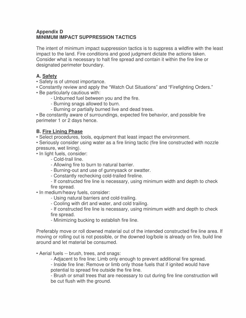
Appendix D MINIMUM IMPACT SUPPRESSION TACTICS The intent of minimum impact suppression tactics is to suppress a wildfire with the least impact to the land. Fire conditions and good judgment dictate the actions taken. Consider what is necessary to halt fire spread and contain it within the fire line or designated perimeter boundary. A. Safety • Safety is of utmost importance. • Constantly review and apply the “Watch Out Situations” and “Firefighting Orders.” • Be particularly cautious with:
- Unburned fuel between you and the fire. - Burning snags allowed to burn. - Burning or partially burned live and dead trees.
• Be constantly aware of surroundings, expected fire behavior, and possible fire perimeter 1 or 2 days hence. B. Fire Lining Phase • Select procedures, tools, equipment that least impact the environment. • Seriously consider using water as a fire lining tactic (fire line constructed with nozzle pressure, wet lining). • In light fuels, consider:
- Cold-trail line. - Allowing fire to burn to natural barrier. - Burning-out and use of gunnysack or swatter. - Constantly rechecking cold-trailed fireline. - If constructed fire line is necessary, using minimum width and depth to check fire spread.
• In medium/heavy fuels, consider: - Using natural barriers and cold-trailing. - Cooling with dirt and water, and cold trailing. - If constructed fire line is necessary, using minimum width and depth to check fire spread. - Minimizing bucking to establish fire line.
Preferably move or roll downed material out of the intended constructed fire line area. If moving or rolling out is not possible, or the downed log/bole is already on fire, build line around and let material be consumed. • Aerial fuels -- brush, trees, and snags:
- Adjacent to fire line: Limb only enough to prevent additional fire spread. - Inside fire line: Remove or limb only those fuels that if ignited would have potential to spread fire outside the fire line. - Brush or small trees that are necessary to cut during fire line construction will be cut flush with the ground.
• Trees, burned trees, and snags: - MINIMIZE cutting of trees, burned trees and snags. - Live trees will not be cut, unless determined they will cause fire spread across the fire line or endanger workers. If tree cutting occurs, cut the stumps flush with the ground. - Scrape around tree bases near fire line if hot and likely to cause fire spread. - Identify hazardous trees with an observer, flagging, and/or glow-sticks.
• When using indirect attack: - Do not fall snags on the intended unburned side of the constructed fire line, unless they are a safety hazard to crews. - On the intended burn-out side of the line, fall only those snags that would reach the fire line should they burn and fall over. Consider alternative means to falling (fire line explosives, bucket drops). - Review items listed above (aerial fuels, brush, trees, and snags).
C. Mop-Up Phase • Consider using “hot-spot” detection devices along perimeter (aerial or hand-held). • Light fuels:
- Cold-trail areas adjacent to unburned fuels. - Do minimal spading; restrict spading to hot areas near fire line. - Use extensive cold-trailing to detect hot areas.
• Medium and heavy fuels: - Cold-trail charred logs near fire line; do minimal scraping or tool scarring. - Minimize bucking of logs to check for hot spots or extinguish fire; preferably roll the logs and extinguish the fire. - Return logs to original position after checking or ground is cool. - Refrain from making bone yards; burned/ partially burned fuels that were moved should be arranged in natural position as much as possible. - Consider allowing larger logs near the fire line to burnout, instead of bucking into manageable lengths. Use lever, etc., to move large logs.
• Aerial fuels – brush, small trees, and limbs. - Remove or limb only those fuels that if ignited, have potential to spread fire outside the fire line.
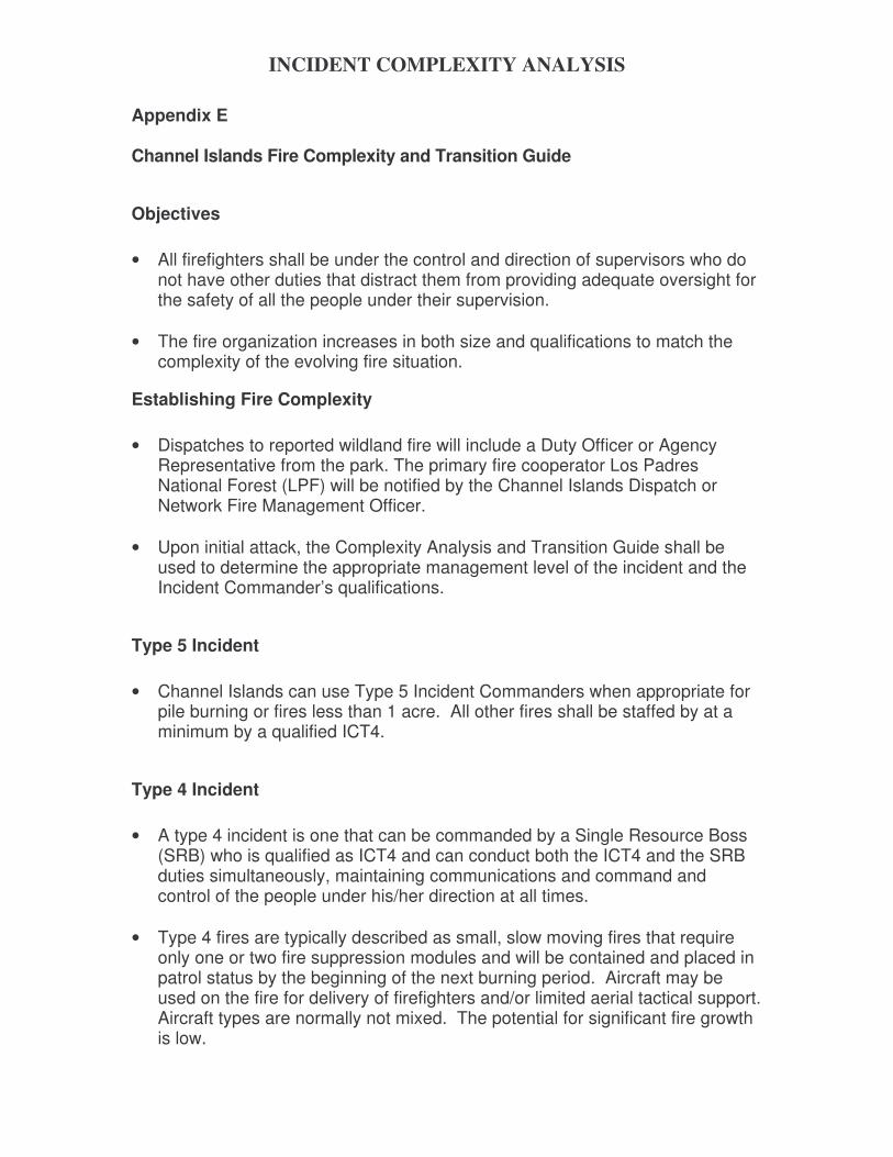
INCIDENT COMPLEXITY ANALYSIS
Appendix E
Channel Islands Fire Complexity and Transition Guide
Objectives • All firefighters shall be under the control and direction of supervisors who do
not have other duties that distract them from providing adequate oversight for the safety of all the people under their supervision.
• The fire organization increases in both size and qualifications to match the
complexity of the evolving fire situation.
Establishing Fire Complexity • Dispatches to reported wildland fire will include a Duty Officer or Agency
Representative from the park. The primary fire cooperator Los Padres National Forest (LPF) will be notified by the Channel Islands Dispatch or Network Fire Management Officer.
• Upon initial attack, the Complexity Analysis and Transition Guide shall be
used to determine the appropriate management level of the incident and the Incident Commander’s qualifications.
Type 5 Incident • Channel Islands can use Type 5 Incident Commanders when appropriate for
pile burning or fires less than 1 acre. All other fires shall be staffed by at a minimum by a qualified ICT4.
Type 4 Incident • A type 4 incident is one that can be commanded by a Single Resource Boss
(SRB) who is qualified as ICT4 and can conduct both the ICT4 and the SRB duties simultaneously, maintaining communications and command and control of the people under his/her direction at all times.
• Type 4 fires are typically described as small, slow moving fires that require
only one or two fire suppression modules and will be contained and placed in patrol status by the beginning of the next burning period. Aircraft may be used on the fire for delivery of firefighters and/or limited aerial tactical support. Aircraft types are normally not mixed. The potential for significant fire growth is low.
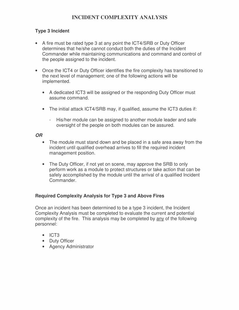
INCIDENT COMPLEXITY ANALYSIS
Type 3 Incident • A fire must be rated type 3 at any point the ICT4/SRB or Duty Officer
determines that he/she cannot conduct both the duties of the Incident Commander while maintaining communications and command and control of the people assigned to the incident.
• Once the ICT4 or Duty Officer identifies the fire complexity has transitioned to
the next level of management; one of the following actions will be implemented.
• A dedicated ICT3 will be assigned or the responding Duty Officer must
assume command. • The initial attack ICT4/SRB may, if qualified, assume the ICT3 duties if:
- His/her module can be assigned to another module leader and safe
oversight of the people on both modules can be assured.
OR • The module must stand down and be placed in a safe area away from the
incident until qualified overhead arrives to fill the required incident management position.
• The Duty Officer, if not yet on scene, may approve the SRB to only
perform work as a module to protect structures or take action that can be safely accomplished by the module until the arrival of a qualified Incident Commander.
Required Complexity Analysis for Type 3 and Above Fires Once an incident has been determined to be a type 3 incident, the Incident Complexity Analysis must be completed to evaluate the current and potential complexity of the fire. This analysis may be completed by any of the following personnel:
• ICT3 • Duty Officer • Agency Administrator
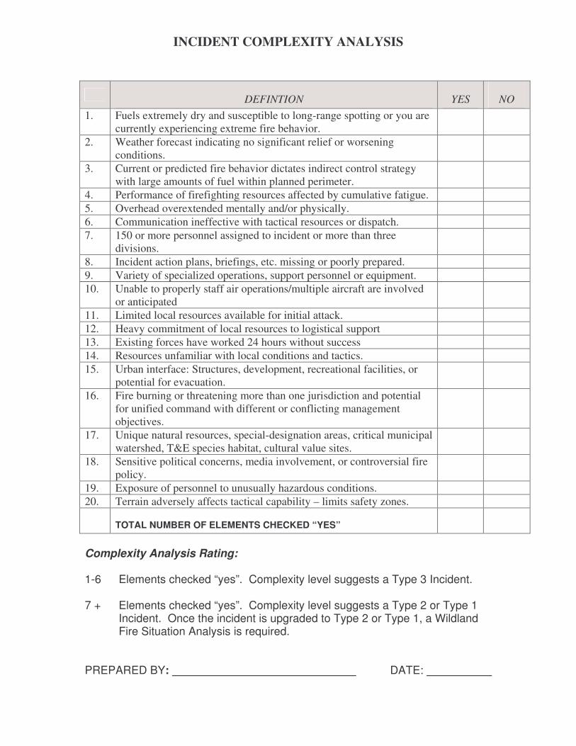
INCIDENT COMPLEXITY ANALYSIS
DEFINTION YES NO 1. Fuels extremely dry and susceptible to long-range spotting or you are
currently experiencing extreme fire behavior.
2. Weather forecast indicating no significant relief or worsening conditions.
3. Current or predicted fire behavior dictates indirect control strategy with large amounts of fuel within planned perimeter.
4. Performance of firefighting resources affected by cumulative fatigue. 5. Overhead overextended mentally and/or physically. 6. Communication ineffective with tactical resources or dispatch. 7. 150 or more personnel assigned to incident or more than three
divisions.
8. Incident action plans, briefings, etc. missing or poorly prepared. 9. Variety of specialized operations, support personnel or equipment. 10. Unable to properly staff air operations/multiple aircraft are involved
or anticipated
11. Limited local resources available for initial attack. 12. Heavy commitment of local resources to logistical support 13. Existing forces have worked 24 hours without success 14. Resources unfamiliar with local conditions and tactics. 15. Urban interface: Structures, development, recreational facilities, or
potential for evacuation.
16. Fire burning or threatening more than one jurisdiction and potential for unified command with different or conflicting management objectives.
17. Unique natural resources, special-designation areas, critical municipal watershed, T&E species habitat, cultural value sites.
18. Sensitive political concerns, media involvement, or controversial fire policy.
19. Exposure of personnel to unusually hazardous conditions. 20. Terrain adversely affects tactical capability – limits safety zones.
TOTAL NUMBER OF ELEMENTS CHECKED “YES”
Complexity Analysis Rating: 1-6 Elements checked “yes”. Complexity level suggests a Type 3 Incident. 7 + Elements checked “yes”. Complexity level suggests a Type 2 or Type 1
Incident. Once the incident is upgraded to Type 2 or Type 1, a Wildland Fire Situation Analysis is required.
PREPARED BY: DATE:
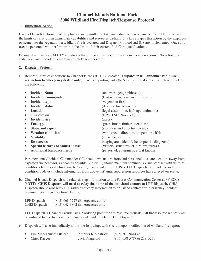
Channel Islands National Park 2006 Wildland Fire Dispatch/Response Protocol
Page 1 of 5
1. Immediate Action Channel Islands National Park employees are permitted to take immediate action on any accidental fire start within the limits of safety, their immediate capabilities and resources on-hand. If a fire escapes this action by the employee on scene into the vegetation, a wildland fire is declared and Dispatch Protocol and ICS are implemented. Once this occurs, personnel will perform within the limits of their current Red-Card qualifications. Personnel and visitor SAFETY are always the primary consideration in an emergency response. No action that endangers any individual’s reasonable safety is authorized. 2. Dispatch Protocol a. Report all fires & conditions to Channel Islands (CHIS) Dispatch. Dispatcher will announce radio-use
restriction to emergency-traffic only, then ask reporting party (RP) to give initial size-up which will include the following:
• Incident Name (one word geographic site) • Incident Commander (lead unit on-scene, until relieved) • Incident type (vegetation fire) • Incident status (describe fire behavior) • Location (legal description, lat/long, landmarks) • Jurisdiction (NPS, TNC, Navy, etc) • Incident size (acres) • Fuel type (grass, brush, timber litter, slash) • Slope and aspect (steepness and direction facing) • Weather conditions (wind speed, direction, temperature, RH) • Visibility (clear, fog, ceiling) • Best access (staging area, identify helicopter landing zone) • Special hazards or values at risk (visitors, structures, cultural resources,) • Additional Resource needs (personnel, equipment, etc. if known)
Park personnel/Incident Commander (IC) should evacuate visitors and personnel to a safe location, away from expected fire behavior, as soon as possible. RP, or IC, should maintain continuous visual contact with wildfire conditions from a safe location. RP, or IC, may be asked by CHIS or LPF Dispatch to provide periodic fire condition updates (include information from above list) until suppression resources have arrived on-scene.
b. Channel Islands Dispatch will relay size-up information to Los Padres Communication Center (LPF ECC).
NOTE: CHIS Dispatch will need to relay the name of the on-island contact to LPF Dispatch. CHIS Dispatch should also relay LPF radio frequency information to on-island contact for Interagency Incident communications (see section 3 below).
LPF Dispatch (805) 961-5727 (Emergencies only) CHIS Dispatch (805) 642-3862 (Emergencies only) LPF Dispatch is Channel Islands’ single ordering point for fire resource requests. All fire resource requests will be initiated by the Incident Commander only and directed to LPF Dispatch.
c. Dispatch will also immediately notify the following, with size-up, upon notification of wildland fire report:
• Fire Management Officer Kathryn Kirkpatrick (805) 501-9444 cell • Chief Ranger Jack Fitzgerald (805) 658-5717 or 218-0251
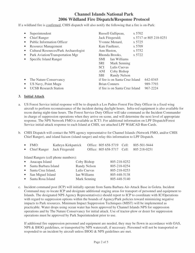
Channel Islands National Park 2006 Wildland Fire Dispatch/Response Protocol
Page 2 of 5
If a wildland fire is confirmed, CHIS dispatch will also notify the following that a fire is on-Park:
• Superintendent Russell Gallipeau, x 5702 • Chief Ranger Jack Fitzgerald; x 5717 or 805 218-0251 • Public Information Officer Yvonne Menard, x 5725 • Resource Management Kate Faulkner, x 5709 • Cultural Resources/Park Archaeologist Ann Huston, x 5752 • Park Aviation/Transportation Mgr Rhonda Brooks, x 5722 • Specific Island Ranger SMI Ian Williams SRI Mark Senning SCI Lulis Cuevas ANI Coby Bishop SBI Randy Nelson • The Nature Conservancy if fire is on Santa Cruz Island 642-0345 • US Navy, Point Mugu Brian Conners 989-7793 • UCSB Research Station if fire is on Santa Cruz Island 967-2224
3. Initial Attack a. US Forest Service initial response will be to dispatch a Los Padres Forest Fire Duty Officer in a fixed wing
aircraft to perform reconnaissance of the incident during daylight hours. Infra-red equipment is also available for recon during night-time hours. The Forest Service Duty Officer will take command as the Incident Commander in charge of suppression operations when they arrive on scene, and will determine the next level of appropriate response. The NPS Network FMO is available as ICT3. For additional information on LPF Dispatch/Forest Service initial-attack response to each Island at CHIS, see attached LPF WildCAD Run-Cards.
b. CHIS Dispatch will contact the NPS agency representative for Channel Islands (Network FMO, and/or CHIS
Chief Ranger), and island liaison (island ranger) and relay this information to LPF Dispatch.
• FMO: Kathryn Kirkpatrick Office: 805 658-5719 Cell: 805-501-9444 • Chief Ranger Jack Fitzgerald Office: 805 658-5717 Cell: 805 218-0251
Island Rangers (cell phone numbers): • Anacapa Island Coby Bishop 805-218-0252 • Santa Barbara Island Randy Nelson 805-218-0254 • Santa Cruz Island, Lulis Cuevas 805-218-0253 • San Miguel Island Ian Williams 805-448-5138 • Santa Rosa Island Mark Senning 805-448-5140
c. Incident command post (ICP) will initially operate from Santa Barbara Air-Attack Base in Goleta. Incident
Command may re-locate ICP and designate additional staging areas for transport of personnel and equipment to Islands. The designated NPS Agency Representative(s) should report to ICP to coordinate with IC/Operations with regard to suppression options within the bounds of Agency/Park policies toward minimizing negative impacts to Park resources. Minimum Impact Suppression Techniques (MIST) will be implemented as practicable. Water drops using ocean water has been approved by Channel Islands NPS for suppression operations and by The Nature Conservancy for initial attack. Use of tractor-plow or dozer for suppression operations must be approved by Park Superintendent prior to use.
If additional fire suppression personnel and equipment are needed, they may be flown in accordance with OAS, NPS & IHOG guidelines, or transported by NPS watercraft, if necessary. Personnel will not be transported or responded to an incident by aircraft unless IHOG & NPS guidelines are met.
Channel Islands National Park 2006 Wildland Fire Dispatch/Response Protocol
Page 3 of 5
d. Some Island LEO rangers are “red-carded” and should be utilized as on-site technical specialists (access maps of sensitive cultural and natural resources, advise on local resources concerns and policies). They should coordinate on-site with air tanker and helicopter assets to protect no-fly zones and to identify important areas to protect via retardant drops (e.g. fox pens, cultural resources)
• Air to ground frequency (170.000) • Crew net (168.200)
e. Current, red-carded CHIS employees dispatched to an incident will respond with initial attack gear including
proper PPE and provisions for the first operational period. For CHIS employees: fire PPE, except appropriate footwear, will be provided by CHIS Fire Management. Securing proper footwear is the responsibility of the red-carded individual.
4. Communications
LPF Dispatch will respond an F3/F4 repeater with operator [172.350(tx), 170.475(rx), tone 151.4], and/or human repeater to facilitate Incident communications. Island Incident operations will be directed through LPF dispatch on LPF channels as follows:
Used for: RX TX LPF Channel Forest Net (simplex) 170.550 170.550 1 Forest Net repeater (duplex) 170.550 169.900 2 LP 3 Tactical 170.475 170.475 3 LP 4 Tactical 172.350 172.350 4 NIFC TAC-2/Crew net 168.200 168.200 5 Air to ground 170.000 170.000 6
LPF Frequency Management Guidelines (LPF Field Procedures Guide, sec 5.4) will be followed for Fire Emergency Response.
4. Extended Attack a. CA-CNP Park Superintendent is responsible for completing the Incident Delegation of Authority. CA-CNP
Management Team and FMO are responsible for developing a Wildland Fire Situation Analysis (WFSA) for the Incident. The Superintendent, (or his designee), will present these documents to the assigned IC, along with a current incident/situation briefing. CA-CNP FMO or Chief Ranger is responsible to complete “significant fire report” form, and notifying PWR Fire Management Staff. FMO is responsible for incident status reporting, recording D1202 into WFIM, and retaining supporting documentation of incident (D1202, narrative, Daily wx & spot forecasts, cumulative fire maps, total cost summary, monitoring data).
b. If there is a need to keep suppression resources on an island for longer than one operational period (12 hours),
arrangements will be made by LPF Dispatch for logistical support. LPF Dispatch will utilize prearranged contracts for prepared food for the first operational period.
c. CA-CNP may be asked to assist with a variety of support needs (including, for example, GIS, RADO, RAWS,
drivers, camp help, etc.) during extended attack operations. In accordance with NPS Pacific West Region policy regarding NPS fires, first priority for incident trainees will be considered from an NPS priority trainee list. Attached is a list of CNP & Mediterranean-Coast Network priority trainees for the current field season.
d. The following is a list of available facilities on-Island. NOTE: fresh and/or potable water supplies are very
limited on all islands.
Channel Islands National Park 2006 Wildland Fire Dispatch/Response Protocol
Page 4 of 5
Santa Cruz Island East Santa Cruz (Scorpion) Campground – 10 crew, or 200 persons Limited on-island transportation – 2 Pickups Water storage – 10,000 gal
Santa Cruz Isthmus (Prisoners) Navy site – 12 beds Camping – 1 crew, 20 persons Limited on-island transportation – 1 x 4WD Pickup, 1x 2WD “six-pack”- limited to the Navy road. Water storage – 15,000 gal TNC (Central Valley)- for TNC-property incidents, by permission only Water storage – spring/well fed, on demand Santa Rosa Island Bechers Bay Ranch 8 – 10 beds Camping – 2 crews, 50 persons On-Island equipment and transportation: 3 pickups (can transport up to 10 passengers total) 1 Type-6 fire engine (280 gallon, w/ 20 gal. foam unit) 1 road grader 1 crane truck 1 track loader Water Storage – 15,000 gal
San Miguel Island
Campground – 30 persons No ground transportation Cooking & showers available at ranger station. Water storage – 5000 gal 4. Boat Transportation to Islands
LPF Dispatch may request NPS water-craft for transportation of personnel, and equipment. A NPS landing craft is available to transport ground equipment to Santa Cruz Island or Santa Rosa Island. These vessels can run after dark if necessary. Ventura Harbor boat ramp should be designated as the rally point when using boat transportation to the Islands. The following are descriptions of CHIS water-craft resources:
• 1 landing craft, suitable for transportation of equipment & incidental personnel (about 5-10 people),
dimensions are 22’ x 78’ area, weight limit 110,000 lbs. GVW.
• 3 boats, suitable for personnel and supply transport, only: Sea Ranger 24 persons; 10,000 lbs. Pacific Ranger 30 persons; 8,000 lbs. Ocean Ranger 48 persons; 40,000 lbs.
Personnel/supply transport is also available for charter via Park concessionaires: Island Packers in Ventura Harbor, and Truth Aquatics in Santa Barbara Harbor.
LPF Dispatch can request staging area at CHIS Headquarters (e.g. “old Island Packers parking lot”).
Channel Islands National Park 2006 Wildland Fire Dispatch/Response Protocol
Page 5 of 5
5. Key Contacts/Radio Identifiers
LPF: Aaron Gelobter Forest FMO Chief 1 (805) 967-6115 (X2, then X2) (805) xx-xxxx (cell) Brad Joos Deputy Forest FMO Chief 2 (805) 967-6115 (X2, then X1) (805) 886-6970 (cell) Linda Lowe ECC Manager Division 6 (805) 938-9142 (X 220) Mike Emmerling ECC Asst. Mgr. Battalion 61 (805) 938-9142 (X 221) Dana D’Andrea Santa Barbara District DC Division 4 (805) 967-3481 (X 220) (805) 886-8360 (cell) Mike Preasmeyer Santa Barbara District BC Battalion 42 (805) 566-0860 (805) 886-6142 Mark Von Tillow Santa Barbara District BC Battalion 41 (805) 967-3481 (X 221) (805) 895-6871 (cell) Lance Cross Ojai District DC Division 5 (805) 646-4348 (X 321) (805) 455-5879 (cell) Mike Strawhun Ojai District BC Battalion 51 (805) 646-4348 (X 324) (805) 798-0507 (cell) Carrie Landon Ojai District BC Battalion 52 (805) 521-1707 (805) 798-3521 (cell) LPF Dispatch, FAX number (805) 961-5797
NPS: Clay Hillin PWR Aviation Contact (360) 696-7549 Sue Husari PWR FMO (510) 817-1371 (office) (415) 613-7752 (cell) (415) 539-9128 (pgr) William Kaage PWR Deputy FM (510) 817-1370 (Oakland)
(559) 565-3128 (Three Rivers) (415) 990-1370 (cell)
Brenda Kauffman PWR FMPA (510) 817-1373 (office) CHIS: Russell Galipeau CHIS Superintendent 101 (805) 658-5702 Jack Fitzgerald CHIS Chief Ranger 201 (805) 658-5717 Kathryn Kirkpatrick Network FMO Chief 71 (805) 501-9444 Rhonda Brooks CHIS Trans/Aviation Mgr 801 (805) 658-5722 CHIS Transportation Dispatch 700 (805) 658-5720
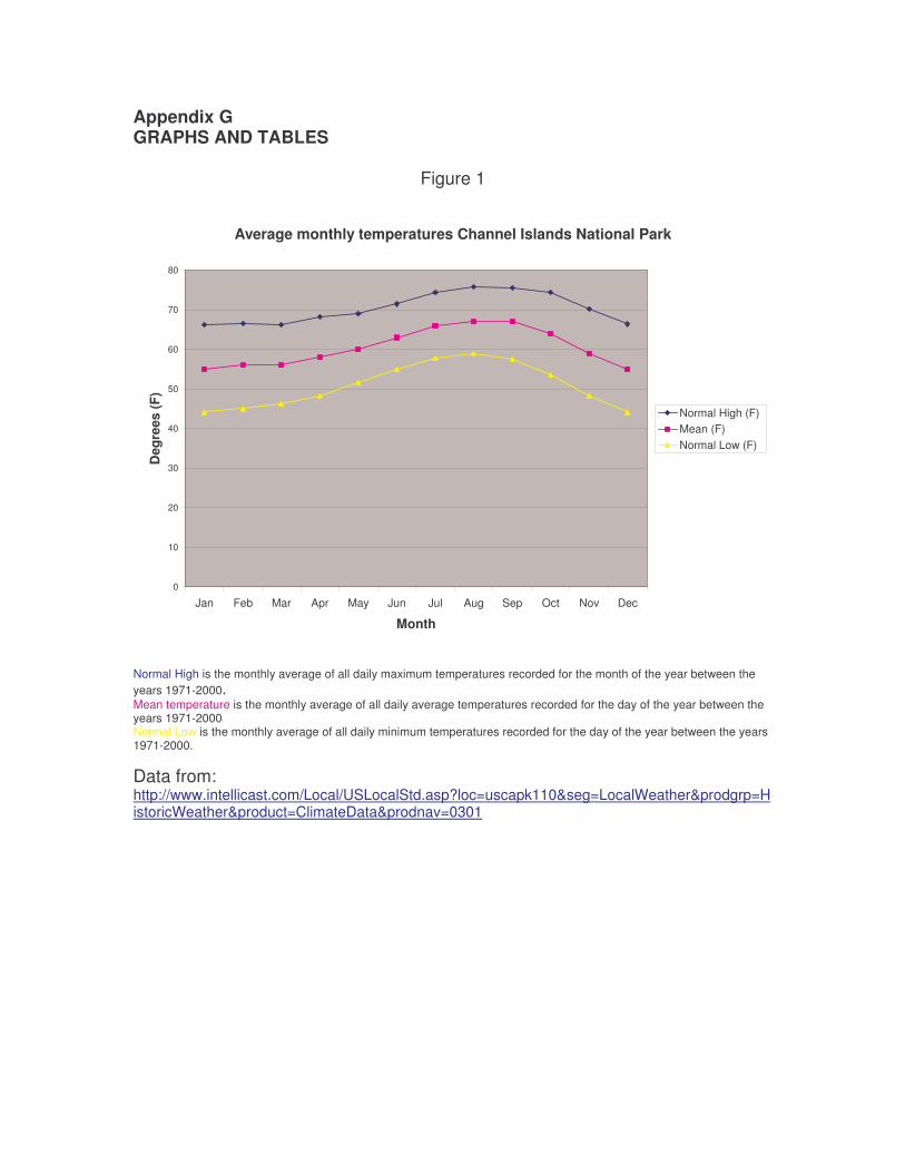
Appendix G GRAPHS AND TABLES
Figure 1
Average monthly temperatures Channel Islands National Park
0
10
20
30
40
50
60
70
80
Jan Feb Mar Apr May Jun Jul Aug Sep Oct Nov Dec
Month
Deg
rees
(F)
Normal High (F) Mean (F)Normal Low (F)
Normal High is the monthly average of all daily maximum temperatures recorded for the month of the year between the years 1971-2000. Mean temperature is the monthly average of all daily average temperatures recorded for the day of the year between the years 1971-2000 Normal Low is the monthly average of all daily minimum temperatures recorded for the day of the year between the years 1971-2000.
Data from: http://www.intellicast.com/Local/USLocalStd.asp?loc=uscapk110&seg=LocalWeather&prodgrp=HistoricWeather&product=ClimateData&prodnav=0301
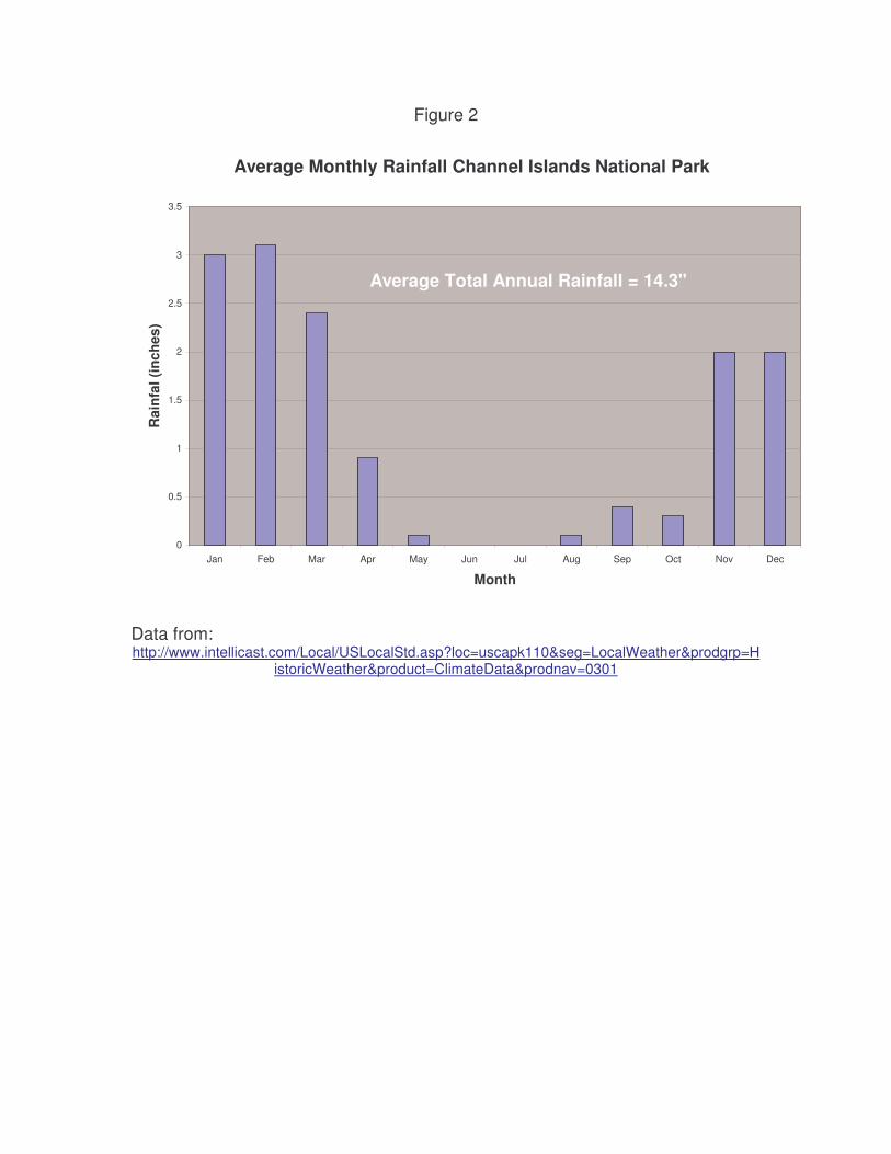
Figure 2
Average Monthly Rainfall Channel Islands National Park
0
0.5
1
1.5
2
2.5
3
3.5
Jan Feb Mar Apr May Jun Jul Aug Sep Oct Nov Dec
Month
Rai
nfal
(inc
hes)
Average Total Annual Rainfall = 14.3"
Data from: http://www.intellicast.com/Local/USLocalStd.asp?loc=uscapk110&seg=LocalWeather&prodgrp=H
istoricWeather&product=ClimateData&prodnav=0301
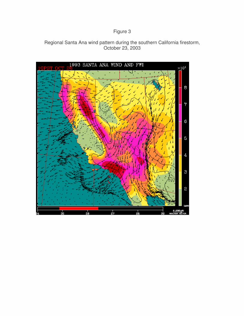
Figure 3
Regional Santa Ana wind pattern during the southern California firestorm, October 23, 2003
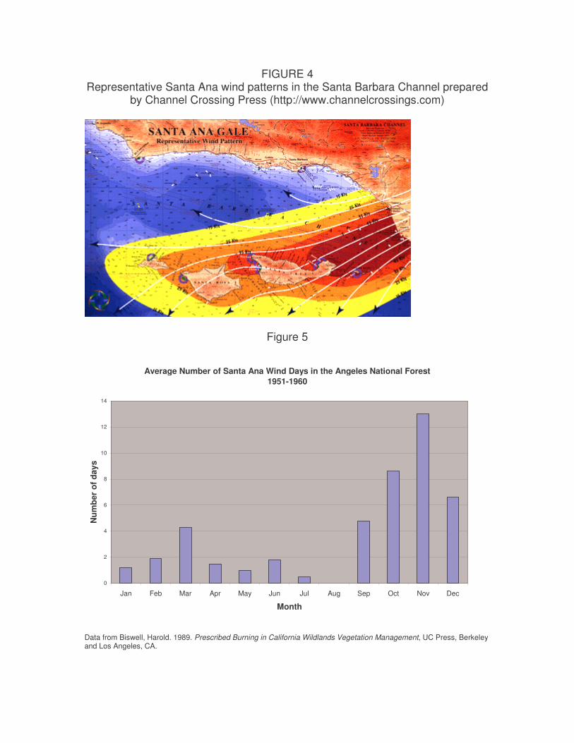
FIGURE 4 Representative Santa Ana wind patterns in the Santa Barbara Channel prepared
by Channel Crossing Press (http://www.channelcrossings.com)
Figure 5
Average Number of Santa Ana Wind Days in the Angeles National Forest 1951-1960
0
2
4
6
8
10
12
14
Jan Feb Mar Apr May Jun Jul Aug Sep Oct Nov Dec
Month
Num
ber
of d
ays
Data from Biswell, Harold. 1989. Prescribed Burning in California Wildlands Vegetation Management, UC Press, Berkeley and Los Angeles, CA.
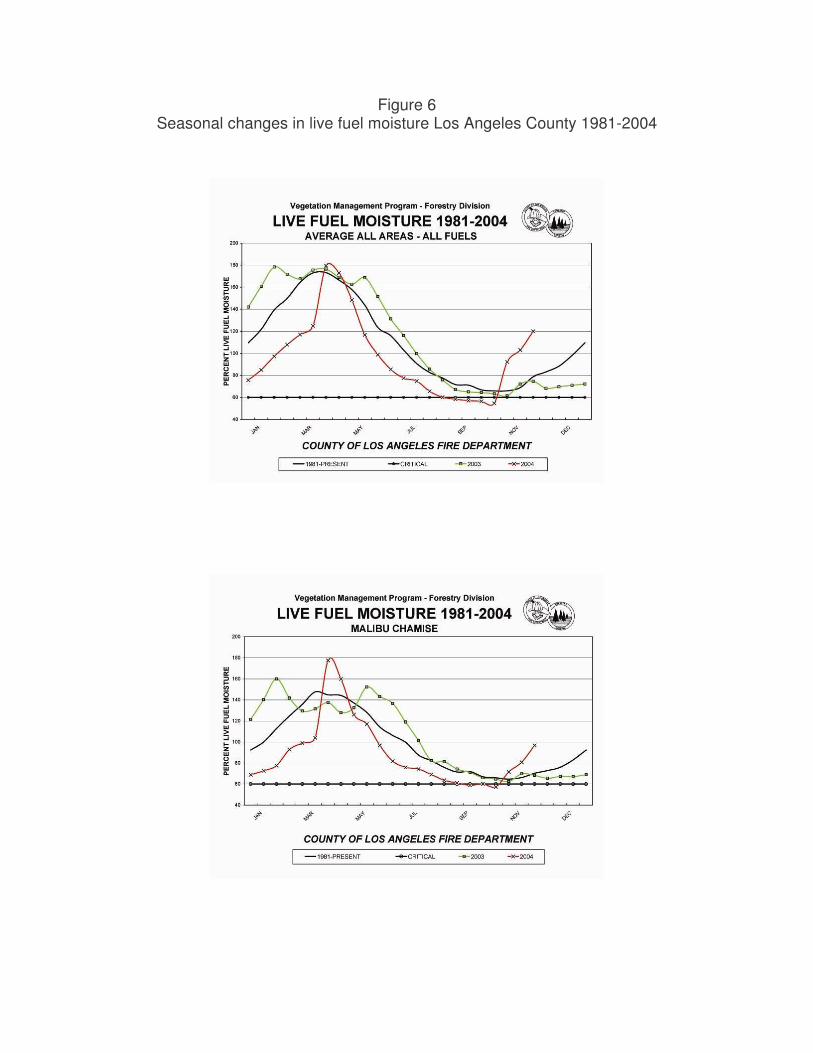
Figure 6 Seasonal changes in live fuel moisture Los Angeles County 1981-2004

Figure 7
Fire frequency and total area burned per month, 1925-2000, Santa Monica Mountains, CA
0%
5%
10%
15%
20%
25%
30%
35%
40%
45%
50%
jan feb mar apr may jun jul aug sep oct nov dec
month
area burned/month
number of fires/ month
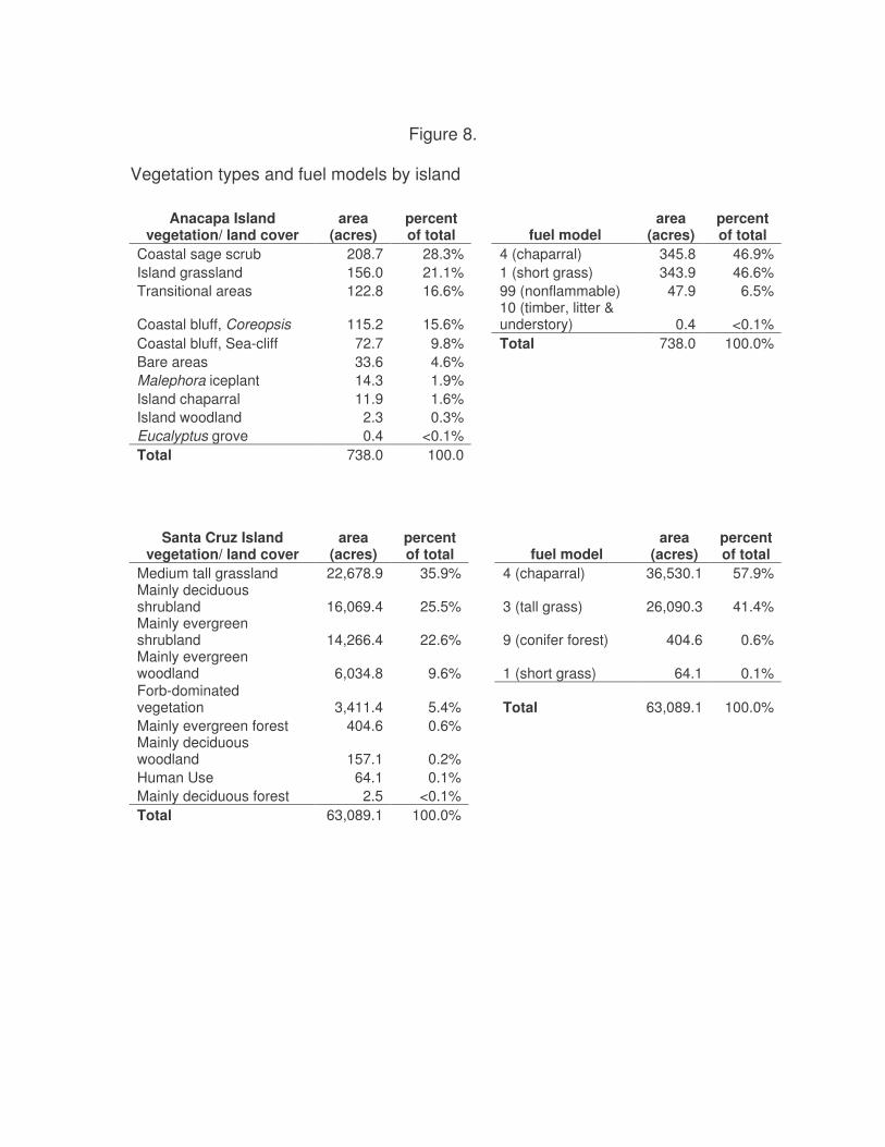
Figure 8.
Vegetation types and fuel models by island
Anacapa Island vegetation/ land cover
area (acres)
percent of total fuel model
area (acres)
percent of total
Coastal sage scrub 208.7 28.3% 4 (chaparral) 345.8 46.9% Island grassland 156.0 21.1% 1 (short grass) 343.9 46.6% Transitional areas 122.8 16.6% 99 (nonflammable) 47.9 6.5%
Coastal bluff, Coreopsis 115.2 15.6% 10 (timber, litter & understory) 0.4 <0.1%
Coastal bluff, Sea-cliff 72.7 9.8% Total 738.0 100.0% Bare areas 33.6 4.6% Malephora iceplant 14.3 1.9% Island chaparral 11.9 1.6% Island woodland 2.3 0.3% Eucalyptus grove 0.4 <0.1% Total 738.0 100.0
Santa Cruz Island vegetation/ land cover
area (acres)
percent of total fuel model
area (acres)
percent of total
Medium tall grassland 22,678.9 35.9% 4 (chaparral) 36,530.1 57.9% Mainly deciduous shrubland 16,069.4 25.5% 3 (tall grass) 26,090.3 41.4% Mainly evergreen shrubland 14,266.4 22.6% 9 (conifer forest) 404.6 0.6% Mainly evergreen woodland 6,034.8 9.6% 1 (short grass) 64.1 0.1% Forb-dominated vegetation 3,411.4 5.4% Total 63,089.1 100.0% Mainly evergreen forest 404.6 0.6% Mainly deciduous woodland 157.1 0.2% Human Use 64.1 0.1% Mainly deciduous forest 2.5 <0.1% Total 63,089.1 100.0%
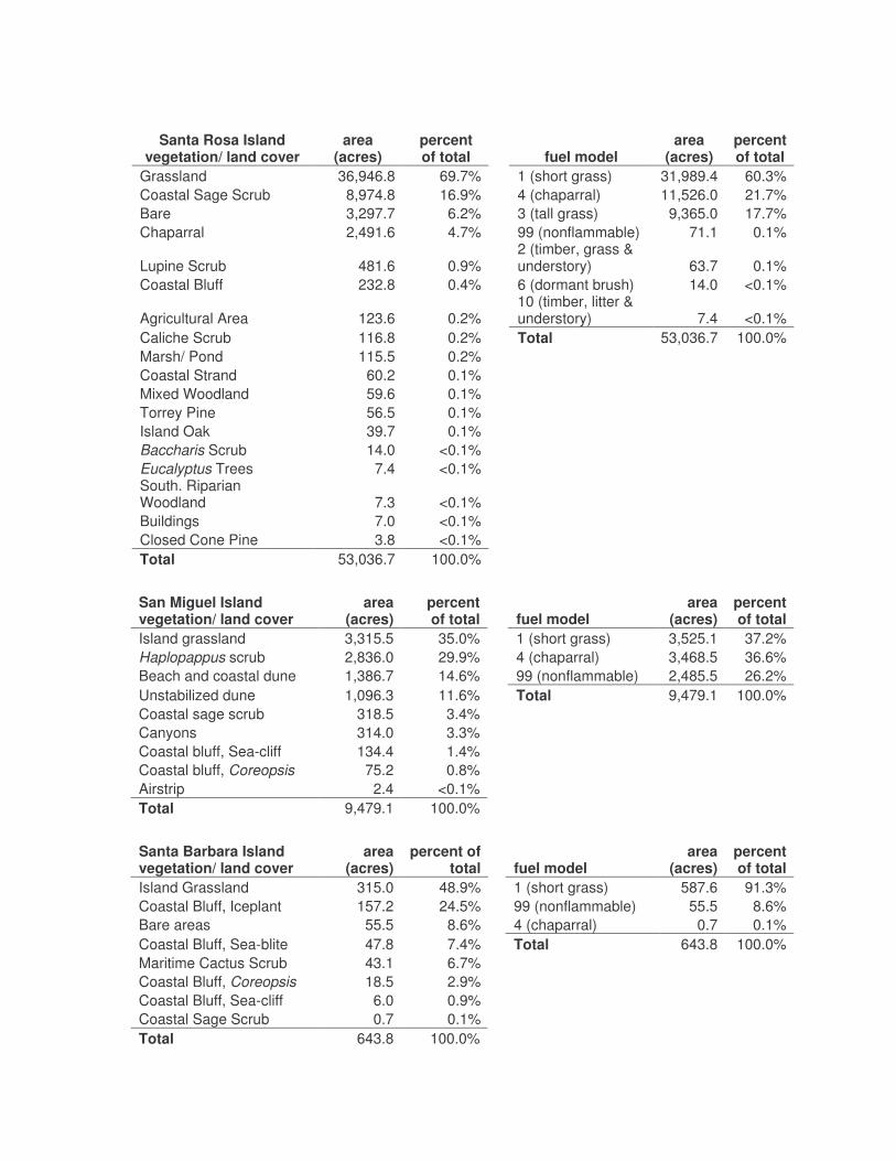
Santa Rosa Island
vegetation/ land cover area
(acres) percent of total fuel model
area (acres)
percent of total
Grassland 36,946.8 69.7% 1 (short grass) 31,989.4 60.3% Coastal Sage Scrub 8,974.8 16.9% 4 (chaparral) 11,526.0 21.7% Bare 3,297.7 6.2% 3 (tall grass) 9,365.0 17.7% Chaparral 2,491.6 4.7% 99 (nonflammable) 71.1 0.1%
Lupine Scrub 481.6 0.9% 2 (timber, grass & understory) 63.7 0.1%
Coastal Bluff 232.8 0.4% 6 (dormant brush) 14.0 <0.1%
Agricultural Area 123.6 0.2% 10 (timber, litter & understory) 7.4 <0.1%
Caliche Scrub 116.8 0.2% Total 53,036.7 100.0% Marsh/ Pond 115.5 0.2% Coastal Strand 60.2 0.1% Mixed Woodland 59.6 0.1% Torrey Pine 56.5 0.1% Island Oak 39.7 0.1% Baccharis Scrub 14.0 <0.1% Eucalyptus Trees 7.4 <0.1% South. Riparian Woodland 7.3 <0.1% Buildings 7.0 <0.1% Closed Cone Pine 3.8 <0.1% Total 53,036.7 100.0%
San Miguel Island vegetation/ land cover
area (acres)
percent of total fuel model
area (acres)
percent of total
Island grassland 3,315.5 35.0% 1 (short grass) 3,525.1 37.2% Haplopappus scrub 2,836.0 29.9% 4 (chaparral) 3,468.5 36.6% Beach and coastal dune 1,386.7 14.6% 99 (nonflammable) 2,485.5 26.2% Unstabilized dune 1,096.3 11.6% Total 9,479.1 100.0% Coastal sage scrub 318.5 3.4% Canyons 314.0 3.3% Coastal bluff, Sea-cliff 134.4 1.4% Coastal bluff, Coreopsis 75.2 0.8% Airstrip 2.4 <0.1% Total 9,479.1 100.0%
Santa Barbara Island vegetation/ land cover
area (acres)
percent of total fuel model
area (acres)
percent of total
Island Grassland 315.0 48.9% 1 (short grass) 587.6 91.3% Coastal Bluff, Iceplant 157.2 24.5% 99 (nonflammable) 55.5 8.6% Bare areas 55.5 8.6% 4 (chaparral) 0.7 0.1% Coastal Bluff, Sea-blite 47.8 7.4% Total 643.8 100.0% Maritime Cactus Scrub 43.1 6.7% Coastal Bluff, Coreopsis 18.5 2.9% Coastal Bluff, Sea-cliff 6.0 0.9% Coastal Sage Scrub 0.7 0.1% Total 643.8 100.0%
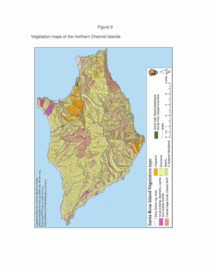
Figure 9
Vegetation maps of the northern Channel Islands
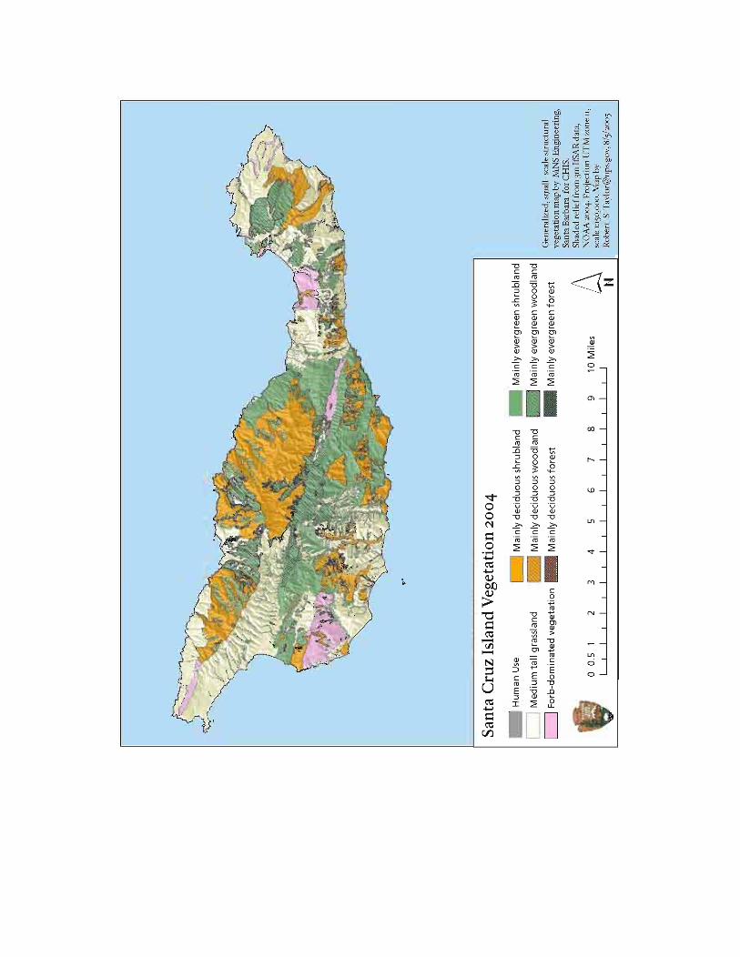
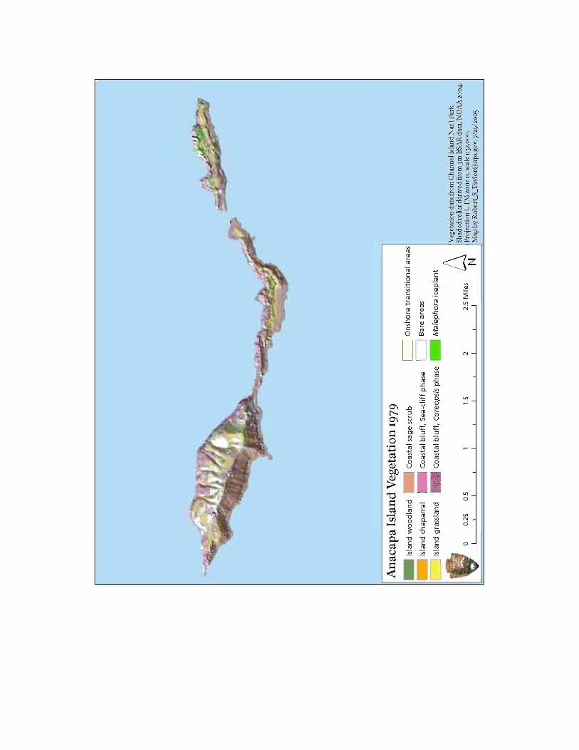
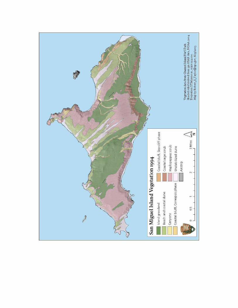
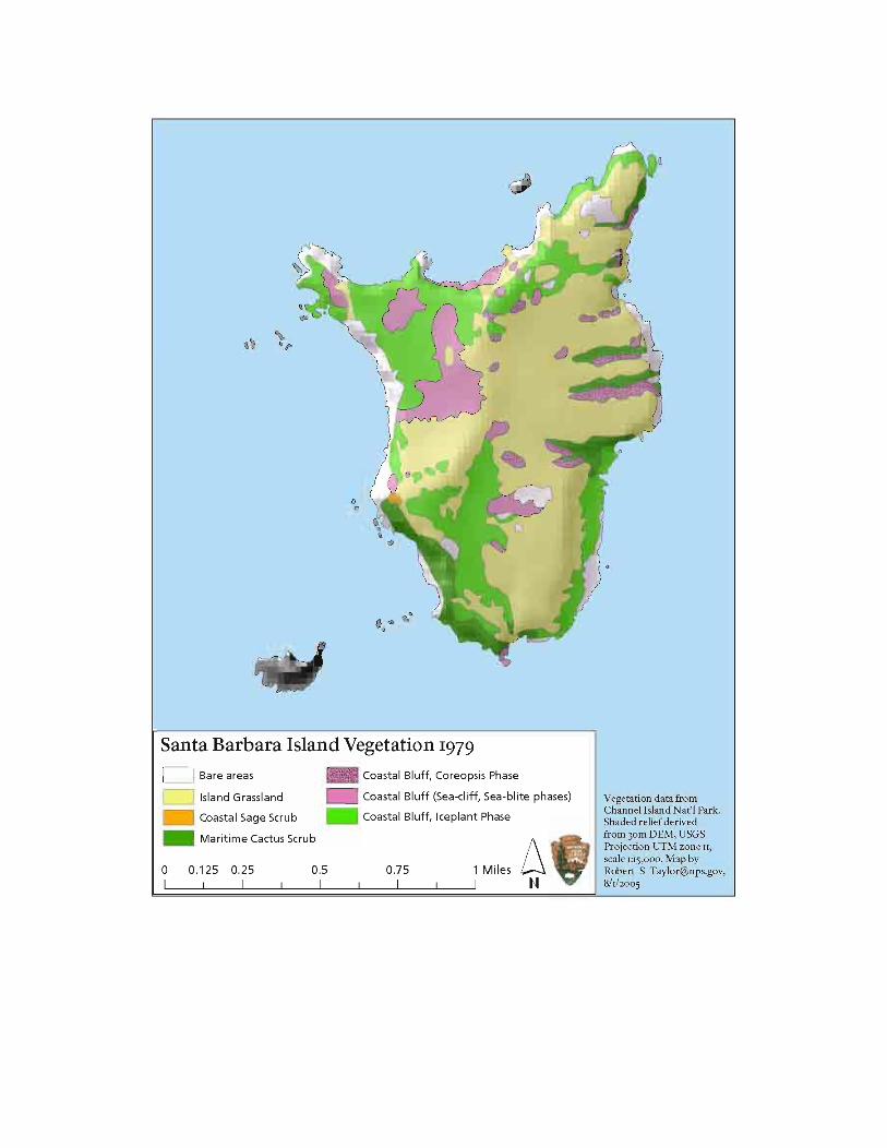
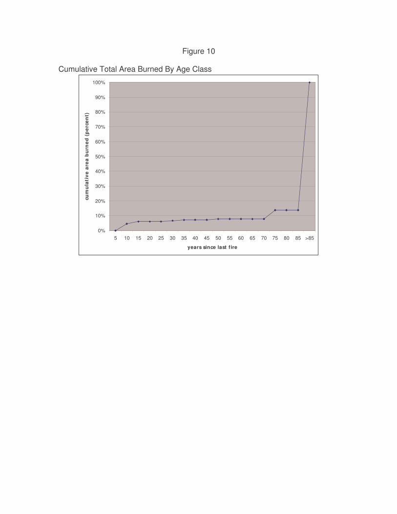
Figure 10 Cumulative Total Area Burned By Age Class
0%
10%
20%
30%
40%
50%
60%
70%
80%
90%
100%
5 10 15 20 25 30 35 40 45 50 55 60 65 70 75 80 85 >85
years since last f ire
cum
ula
tive
are
a b
urn
ed (
per
cen
t)
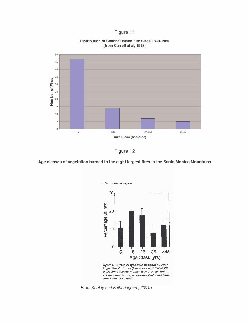
Figure 11
Distribution of Channel Island Fire Sizes 1830-1986 (from Carroll et al, 1993)
0
5
10
15
20
25
30
35
40
45
50
1-9 10-99 100-999 1000+
Size Class (hectares)
Num
ber
of F
ires
Figure 12
Age classes of vegetation burned in the eight largest fires in the Santa Monica Mountains
From Keeley and Fotheringham, 2001b
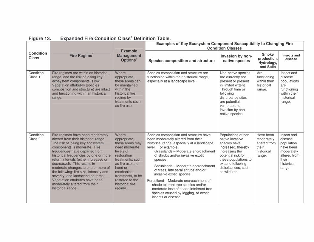
Figure 13. Expanded Fire Condition Classa Definition Table. Examples of Key Ecosystem Component Susceptibility to Changing Fire
Condition Classes Condition Class Fire Regime1
Example Management
Options1 Species composition and structure Invasion by non-native species
Smoke production, Hydrology, and Soils
Insects and disease
Condition Class 1
Fire regimes are within an historical range, and the risk of losing key ecosystem components is low. Vegetation attributes (species composition and structure) are intact and functioning within an historical range.
Where appropriate, these areas can be maintained within the historical fire regime by treatments such as fire use.
Species composition and structure are functioning within their historical range, especially at a landscape level.
Non-native species are currently not present or present in limited extent. Through time or following disturbance sites are potential vulnerable to invasion by non-native species.
Are functioning within their historical range.
Insect and disease populations are functioning within their historical range.
Condition Class 2
Fire regimes have been moderately altered from their historical range. The risk of losing key ecosystem components is moderate. Fire frequencies have departed from historical frequencies by one or more return intervals (either increased or decreased). This results in moderate changes to one or more of the following: fire size, intensity and severity, and landscape patterns. Vegetation attributes have been moderately altered from their historical range.
Where appropriate, these areas may need moderate levels of restoration treatments, such as fire use and hand or mechanical treatments, to be restored to the historical fire regime.
Species composition and structure have been moderately altered from their historical range, especially at a landscape level. For example:
Grasslands – Moderate encroachment of shrubs and/or invasive exotic species.
Shrublands – Moderate encroachment of trees, late seral shrubs and/or invasive exotic species.
Forestland – Moderate encroachment of shade tolerant tree species and/or moderate lose of shade intolerant tree species caused by logging, or exotic insects or disease.
Populations of non-native invasive species have increased, thereby increasing the potential risk for these populations to expand following disturbances, such as wildfires.
Have been moderately altered from their historical range.
Insect and disease population have been moderately altered from their historical range.
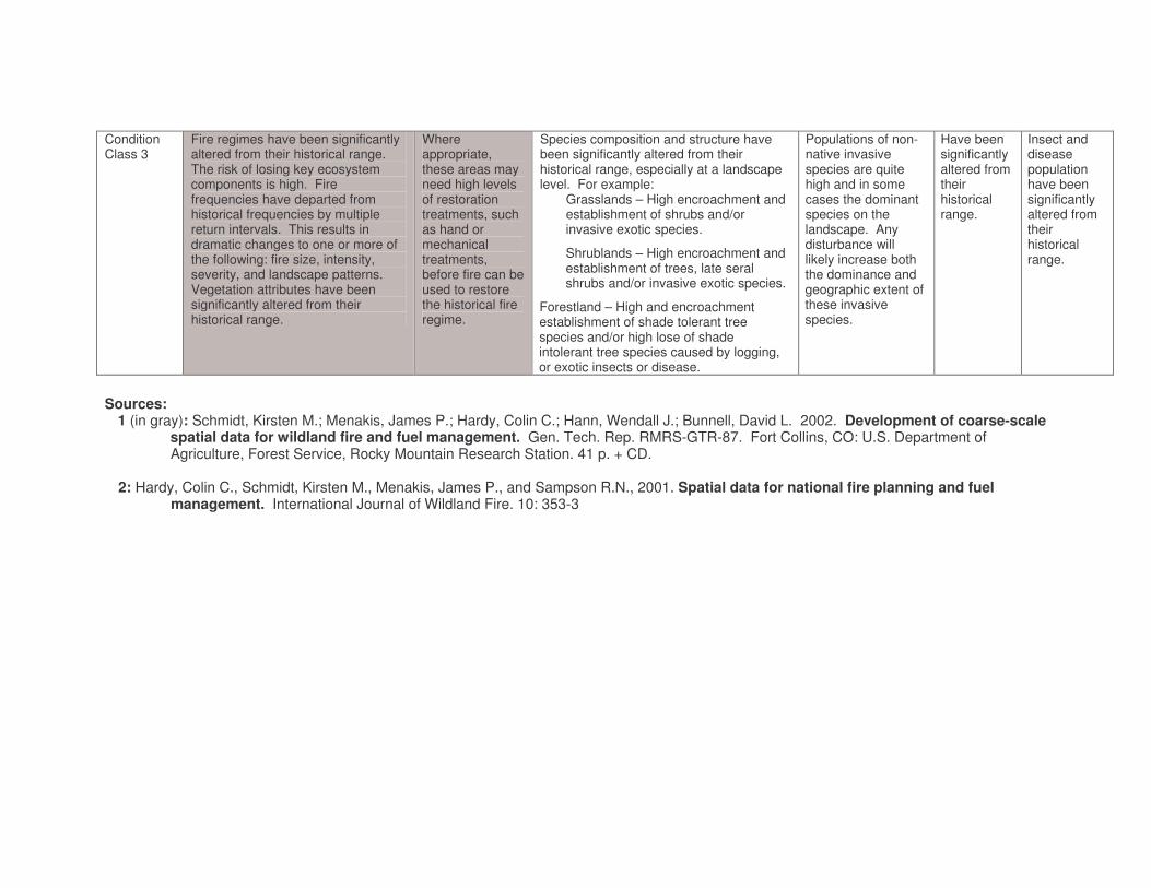
Condition Class 3
Fire regimes have been significantly altered from their historical range. The risk of losing key ecosystem components is high. Fire frequencies have departed from historical frequencies by multiple return intervals. This results in dramatic changes to one or more of the following: fire size, intensity, severity, and landscape patterns. Vegetation attributes have been significantly altered from their historical range.
Where appropriate, these areas may need high levels of restoration treatments, such as hand or mechanical treatments, before fire can be used to restore the historical fire regime.
Species composition and structure have been significantly altered from their historical range, especially at a landscape level. For example:
Grasslands – High encroachment and establishment of shrubs and/or invasive exotic species.
Shrublands – High encroachment and establishment of trees, late seral shrubs and/or invasive exotic species.
Forestland – High and encroachment establishment of shade tolerant tree species and/or high lose of shade intolerant tree species caused by logging, or exotic insects or disease.
Populations of non-native invasive species are quite high and in some cases the dominant species on the landscape. Any disturbance will likely increase both the dominance and geographic extent of these invasive species.
Have been significantly altered from their historical range.
Insect and disease population have been significantly altered from their historical range.
Sources:
1 (in gray): Schmidt, Kirsten M.; Menakis, James P.; Hardy, Colin C.; Hann, Wendall J.; Bunnell, David L. 2002. Development of coarse-scale spatial data for wildland fire and fuel management. Gen. Tech. Rep. RMRS-GTR-87. Fort Collins, CO: U.S. Department of Agriculture, Forest Service, Rocky Mountain Research Station. 41 p. + CD.
2: Hardy, Colin C., Schmidt, Kirsten M., Menakis, James P., and Sampson R.N., 2001. Spatial data for national fire planning and fuel
management. International Journal of Wildland Fire. 10: 353-3
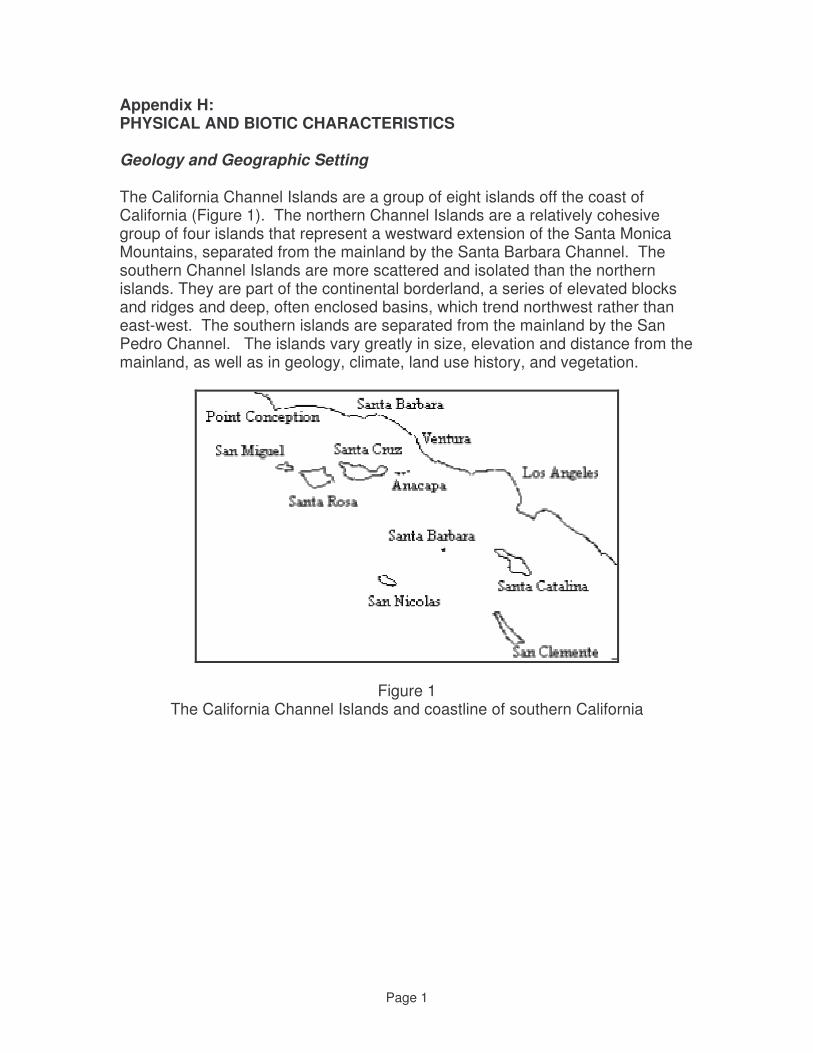
Page 1
Appendix H: PHYSICAL AND BIOTIC CHARACTERISTICS Geology and Geographic Setting
The California Channel Islands are a group of eight islands off the coast of California (Figure 1). The northern Channel Islands are a relatively cohesive group of four islands that represent a westward extension of the Santa Monica Mountains, separated from the mainland by the Santa Barbara Channel. The southern Channel Islands are more scattered and isolated than the northern islands. They are part of the continental borderland, a series of elevated blocks and ridges and deep, often enclosed basins, which trend northwest rather than east-west. The southern islands are separated from the mainland by the San Pedro Channel. The islands vary greatly in size, elevation and distance from the mainland, as well as in geology, climate, land use history, and vegetation.
Figure 1 The California Channel Islands and coastline of southern California
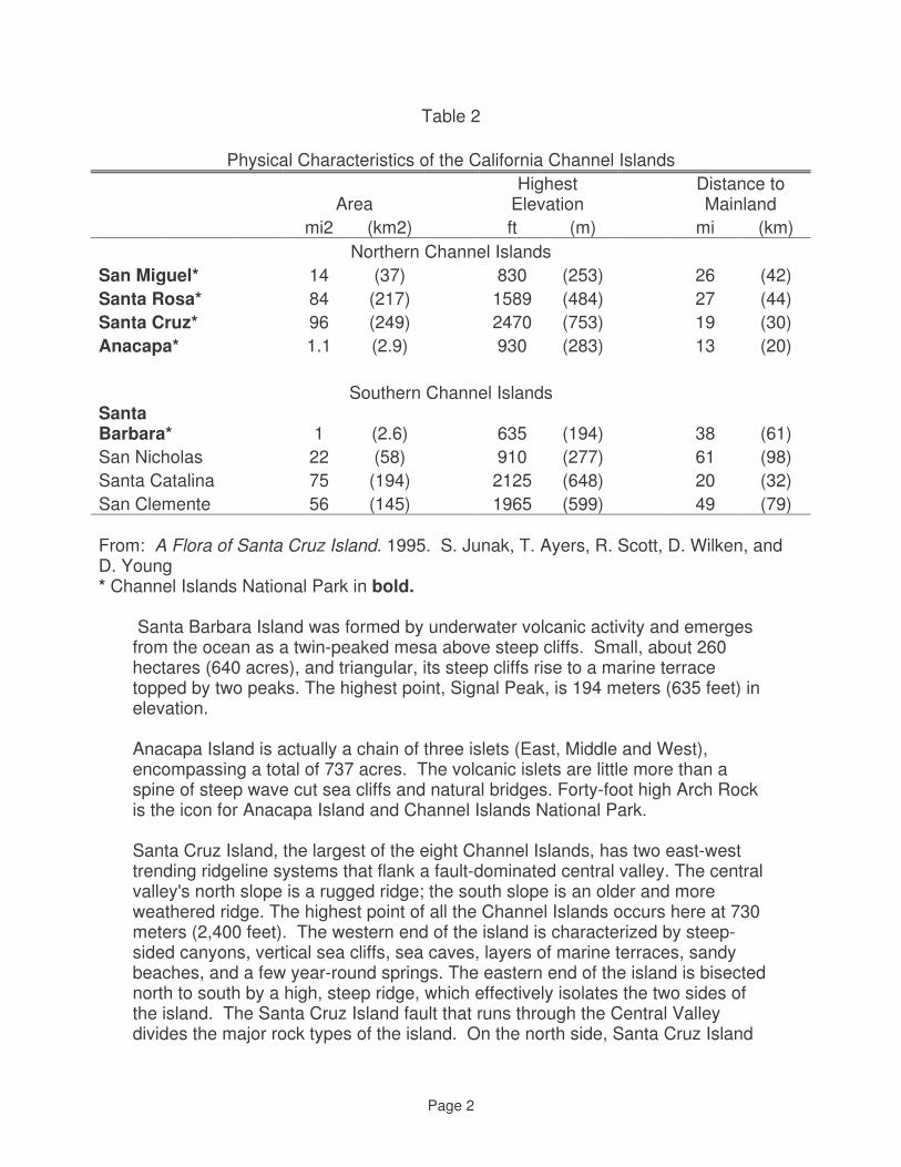
Page 2
Table 2
Physical Characteristics of the California Channel Islands
Area Highest
Elevation Distance to Mainland
mi2 (km2) ft (m) mi (km) Northern Channel Islands
San Miguel* 14 (37) 830 (253) 26 (42) Santa Rosa* 84 (217) 1589 (484) 27 (44) Santa Cruz* 96 (249) 2470 (753) 19 (30) Anacapa* 1.1 (2.9) 930 (283) 13 (20)
Southern Channel Islands Santa Barbara* 1 (2.6) 635 (194) 38 (61) San Nicholas 22 (58) 910 (277) 61 (98) Santa Catalina 75 (194) 2125 (648) 20 (32) San Clemente 56 (145) 1965 (599) 49 (79) From: A Flora of Santa Cruz Island. 1995. S. Junak, T. Ayers, R. Scott, D. Wilken, and D. Young * Channel Islands National Park in bold.
Santa Barbara Island was formed by underwater volcanic activity and emerges from the ocean as a twin-peaked mesa above steep cliffs. Small, about 260 hectares (640 acres), and triangular, its steep cliffs rise to a marine terrace topped by two peaks. The highest point, Signal Peak, is 194 meters (635 feet) in elevation. Anacapa Island is actually a chain of three islets (East, Middle and West), encompassing a total of 737 acres. The volcanic islets are little more than a spine of steep wave cut sea cliffs and natural bridges. Forty-foot high Arch Rock is the icon for Anacapa Island and Channel Islands National Park. Santa Cruz Island, the largest of the eight Channel Islands, has two east-west trending ridgeline systems that flank a fault-dominated central valley. The central valley's north slope is a rugged ridge; the south slope is an older and more weathered ridge. The highest point of all the Channel Islands occurs here at 730 meters (2,400 feet). The western end of the island is characterized by steep-sided canyons, vertical sea cliffs, sea caves, layers of marine terraces, sandy beaches, and a few year-round springs. The eastern end of the island is bisected north to south by a high, steep ridge, which effectively isolates the two sides of the island. The Santa Cruz Island fault that runs through the Central Valley divides the major rock types of the island. On the north side, Santa Cruz Island
Page 3
Volcanics dominate except on the isthmus and portions of the eastern end of the island where the volcanics are overlain by the Monterey formation, Miocene shale. The south side of the island is more diverse with high elevation areas dominated by Jurassic basement plutonic and metamorphic rocks. The rest of the island is characterized by Eocene to Miocene sedimentatary and metamorphic rocks, with minor amounts of Pleistocene alluvial deposits. Santa Rosa Island is the second largest of the Channel Islands. Roughly diamond-shaped, it is 15 miles long and 10 miles wide. Santa Rosa includes steep canyons, rocky intertidal regions, sand dunes, isolated beaches, and grass-covered, rolling hills. San Miguel Island is the northernmost and farthest west of the Channel Islands. It is primarily a plateau 120-150 meters (400-500 feet) in elevation from which two rounded hills emerge. The windswept dunes of the San Miguel plateau are 8 miles long and 4 miles wide, covering 9,376 acres. The coastline is rocky, with shoreline cliffs relieved by sandy beaches, where more than 100,000 seals and sea lions breed and haul out. The Channel Islands' best examples of caliche forest are found here. The origin of the Channel Islands was through tectonic uplifting of predominately marine sedimentary rocks and submarine Miocene volcanic rock during the Pliocene era. The length of time that terrestrial conditions have existed since emergence from the submarine environment is estimated to be 4 million years. The history of uplift and wave erosion of marine sedimentary rock are especially evident in the sequential series of wave cut marine terraces on Santa Rosa Island.
Fluctuating sea level changes during the Pleistocene, in conjunction with variable uplift throughout the continental borderlands, combine to create a complex history between the amount of island area emergent and submerged over time. During mid Pleistocene (1 million YBP) only the highest elevations of Santa Catalina, Santa Cruz and Santa Rosa were not submerged. During the most recent ice age, 18,000-20,000 YBP, eustatic sea level was lowered ± 100 m and the northern Channel islands formed a single land mass (Santarosae). The area of the smaller islands was also dramatically larger at this time, for example, the area of San Nicholas was quadrupled. The northern Channel Islands were ultimately isolated from each other 10,000-12,000 YBP when sea level rose as the world’s climate warmed and ice sheets melted.
Vegetation Terrestrial Vegetative Communities and Flora Channel Islands National Park supports a diverse terrestrial flora, including many rare, relict, and endemic species, as well as many nonnative species. Numerous
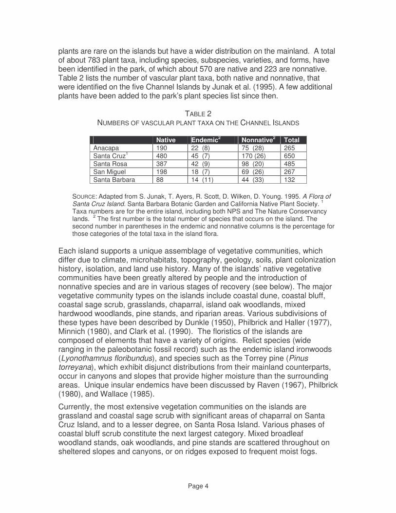
Page 4
plants are rare on the islands but have a wider distribution on the mainland. A total of about 783 plant taxa, including species, subspecies, varieties, and forms, have been identified in the park, of which about 570 are native and 223 are nonnative. Table 2 lists the number of vascular plant taxa, both native and nonnative, that were identified on the five Channel Islands by Junak et al. (1995). A few additional plants have been added to the park’s plant species list since then.
TABLE 2
NUMBERS OF VASCULAR PLANT TAXA ON THE CHANNEL ISLANDS
Native Endemic2 Nonnative2 Total Anacapa 190 22 (8) 75 (28) 265 Santa Cruz1 480 45 (7) 170 (26) 650 Santa Rosa 387 42 (9) 98 (20) 485 San Miguel 198 18 (7) 69 (26) 267 Santa Barbara 88 14 (11) 44 (33) 132
SOURCE: Adapted from S. Junak, T. Ayers, R. Scott, D. Wilken, D. Young. 1995. A Flora of Santa Cruz Island. Santa Barbara Botanic Garden and California Native Plant Society. 1 Taxa numbers are for the entire island, including both NPS and The Nature Conservancy lands. 2 The first number is the total number of species that occurs on the island. The second number in parentheses in the endemic and nonnative columns is the percentage for those categories of the total taxa in the island flora.
Each island supports a unique assemblage of vegetative communities, which differ due to climate, microhabitats, topography, geology, soils, plant colonization history, isolation, and land use history. Many of the islands’ native vegetative communities have been greatly altered by people and the introduction of nonnative species and are in various stages of recovery (see below). The major vegetative community types on the islands include coastal dune, coastal bluff, coastal sage scrub, grasslands, chaparral, island oak woodlands, mixed hardwood woodlands, pine stands, and riparian areas. Various subdivisions of these types have been described by Dunkle (1950), Philbrick and Haller (1977), Minnich (1980), and Clark et al. (1990). The floristics of the islands are composed of elements that have a variety of origins. Relict species (wide ranging in the paleobotanic fossil record) such as the endemic island ironwoods (Lyonothamnus floribundus), and species such as the Torrey pine (Pinus torreyana), which exhibit disjunct distributions from their mainland counterparts, occur in canyons and slopes that provide higher moisture than the surrounding areas. Unique insular endemics have been discussed by Raven (1967), Philbrick (1980), and Wallace (1985).
Currently, the most extensive vegetation communities on the islands are grassland and coastal sage scrub with significant areas of chaparral on Santa Cruz Island, and to a lesser degree, on Santa Rosa Island. Various phases of coastal bluff scrub constitute the next largest category. Mixed broadleaf woodland stands, oak woodlands, and pine stands are scattered throughout on sheltered slopes and canyons, or on ridges exposed to frequent moist fogs.

Page 5
Smaller but no less significant vegetation communities include coastal dune, baccharis scrub, caliche scrub, and wetlands. Coastal beach and associated dune habitats occur in the windiest sandy locations on all the northern islands but Anacapa, and coastal bluffs occur on all the islands. These coastal habitats appear to be relatively undisturbed compared to their counterparts on the mainland, where development and recreation have largely eliminated them. Because of its steep slope and general inaccessibility, coastal bluff habitat has provided a refugium from the habitat elimination that has accompanied alien herbivore grazing on the islands (Minnich 1980; Halvorson et al. 1992).
Coastal sage scrub is composed of soft-leaved, soft-stemmed plants that are palatable to browsers and grazers. The original coastal sage scrub habitat was reduced by overgrazing to the extent that it persists only in locations that are inaccessible to grazing and browsing animals, as in patches of cactus and on bluffs and canyon walls (Minnich 1980; Hobbs 1983). Coastal sage scrub has recovered well on the portion of SCI where sheep were removed nearly twenty years ago.
Before the introduction of alien animals (both livestock and wildlife), the upland habitat was largely shrubland; now, many of its representative species are found only on bluff sites (D'Antonio et al. 1992). The grasslands have greatly expanded at the expense of most other habitat types, and are largely composed of non-native annual species (Hobbs 1983; Cole 1994). In contrast, historical photographs reveal woody vegetation that has been lost from the islands during the last 100 years (Hobbs 1980; Minnich 1980). On Anacapa and San Miguel Islands, where grazing has been removed for over 50 years, the coastal sage scrub habitat has increased in extent (Johnson 1980). Here, the uncontrolled effects of grazing which eliminated or drastically reduced shrubland and artificially increased grasslands are diminishing.
The pre-grazing importance of cactus in the island communities may never be known, because overgrazing results in the spread of cactus to areas that have been denuded by livestock. Overgrazing on Santa Cruz Island greatly facilitated the spread of cactus to the point that over 40% of the “rangeland” was rendered useless for grazing (Hochberg et al. 1980a). On both Santa Cruz and Santa Rosa islands, a biological control agent, cocchineal scale, was employed to suppress cactus and improve grazing opportunities, have dramatically reduced cactus populations (Hochberg et al. 1980a). The scale insect persists on the islands.
The physical condition of the remnant chaparral habitats has been modified by grazing which has altered understory species composition, and by browsing that has pruned shrubs into unnatural, arborescent or tree-like shapes. Browsing by deer and elk on Santa Rosa Island and sheep on Santa Cruz Island has created an open “skeleton” community, reticulated by game trails, resulting in herbivore access to nearly 100% of the habitat (Hochberg et al. 1980a; Tim Thomas,
Page 6
USFWS, pers. obs. 1993). In contrast, historic reports on the conditions of the islands relate that the brushlands were impenetrable (Hochberg et al. 1980a).
Island woodlands are dominated by unique endemic tree species and have been affected heavily by grazing, browsing, and rooting animals seeking summer shelter and food (Clark et al. 1990; Halvorson 1993). Reproduction of tree species has been minimal in most stands. Fragmentation within their ranges and lack of structural diversity within the stands threaten continued viability of these communities. It is hoped that the removal of cattle from SRI and sheep from SCI will reverse this situation. Bishop pine forests areas that are protected from grazing have well-developed foliar cover and pine reproduction (Hobbs 1978). In contrast, Clark et al. (1990) report that on Santa Rosa Island, Bishop pine forests subjected to grazing lack the protective nutrient layer of ground litter and exhibit no reproduction. One exception to this is the Torrey pines, where significant recruitment is occurring. It is believed that these native trees currently occupy most of their potential range (Clark et al. 1990)
Riparian habitats are one of the most significant vegetation communities on the islands and throughout the arid west. The island riparian habitats have been heavily modified physically and structurally, and in some areas have been eliminated completely (Hochberg et al. 1980a; Minnich 1980). Normally, a canyon with year-round water will have well-developed riparian vegetation including willows (Salix spp.), cottonwoods (Populus spp.) and oaks (Quercus spp.). This vegetation would typically support a rich diversity of organisms, especially neo-tropical migratory bird species (Paul Collins, pers. comm. 1994). There are sufficient examples of remnant riparian communities on the islands to demonstrate that this condition occurred prior to the ranching era. However, years of livestock over-utilization have considerably reduced this resource-rich habitat.
Anacapa Island About 190 species of native plants have been documented on Anacapa. The differences in topography and exposure have resulted in a more varied assemblage of plant communities than would be expected for the size of this island. Grasslands, shrub communities, and woodlands of limited distribution are found here. Middle and West Anacapa support more native species than East Anacapa because they have more topographic variation and have not been extensively developed, as was East Anacapa. These two islets are rich in native perennial bunchgrasses and have extensive stands of coreposis scrub, where giant coreopsis (Coreopsis gigantea) and island liveforever (Dudleya caespitosa) grow. Many consider the large stands of bright-flowering giant coreposis to be one of the park’s outstanding vegetation features. Deep, moist canyons on north-facing slopes of West Anacapa contain small oak woodlands and stands of island chaparral. All three islets have sea cliff scrub on their northern slopes and coastal sage scrub or cactus scrub on their southern slopes. These communities are well developed on West Anacapa, moderately developed on Middle Anacapa, and marginally

Page 7
developed on East Anacapa. Mixed annual and perennial grasslands are well distributed on East Anacapa and Middle Anacapa, but are patchier on West Anacapa. Large areas of East Anacapa are also covered by nonnative perennial iceplant, primarily red-flowered iceplant (Malephora crocea). Iceplant is as yet very limited in extent on the other two islets. Although East Anacapa has been considerably altered, the rate and extent of the natural recovery of disturbed areas has been remarkable. The islet’s inaccessible bluffs still support undisturbed communities. Santa Cruz Island East End NPS lands comprise the eastern quarter of the island. About 480 native vascular plant species are known to grow on Santa Cruz, many of which are on NPS lands. Large portions of the east end of Santa Cruz are currently grassland dominated, with remnant areas of coastal bluff scrub, chaparral, coastal sage scrub, coyote-brush scrub, woodlands, and wetlands (riparian, coastal marshes and estuaries, vernal pools, discussed earlier). Grasslands grow mostly on the coastal terraces and broad plateaus at the east end and extend up the broader ridges into the steep rocky slopes to the west. The more prevalent nonnative annual grasses include rip-gut brome (Bromus diandrus), soft-chess (B. hordeacous), red brome (B. madritensis ssp. rubens), wild oats (Avena fatua, A. barbata), ryegrass (Lolium multiflorum), and foxtail barley (Hordeum murinum). Perennial native grasses such as purple needlegrass (Nassella pulchra) and California barley (Hordeum brachyantherum ssp. californicum) are becoming more extensive as natural recovery from sheep grazing progresses. Also scattered throughout the grasslands are solitary shrubs such as lemonade berry (Rhus integrifolia), manzanita (Arctostaphylos spp.), and island wild lilac (Ceanothus spp); seedlings of these shrubs are increasing rapidly. It is believed that with the absence of grazing these native shrubs will continue to expand and change what is now annual grassland back to native shrub communities, such as coastal sage scrub and island chaparral (NPS 2002a). Another widespread vegetation community found at elevations below 500 feet, on moderate slopes and flats, is coyote-brush scrub. It intergrades with coastal sage scrub on rocky slopes. This shrubland primarily grows on deep, unstable soils that are continually disturbed by natural forces. Many species found in the community are weedy nonnatives, particularly annual grasses and fennel (Foeniculum vulgare). Some areas of annual grassland/Baccharis scrub, such as those in the Del Norte area on the isthmus, are dominated by tall stands of fennel, particularly on intrinsically unstable clay soils that cover much of this area. Coastal sage scrub grows on dry, rocky slopes throughout the island, but particularly on south-facing slopes. It intergrades with grasslands on gentle slopes
Page 8
with deeper soils, and with island chaparral on rocky north-facing slopes. Much of this community has been altered by browsing and grazing, and is it currently dominated by nonnative annual grasses. However, some intact areas are on the slopes east of Valley Anchorage on the isthmus. In these areas nearly impenetrable thickets of shrubs about 3 to 4 feet tall grow. Dominant species in this community include California sagebrush (Artemisia californica), island paintbrush (Castilleja lanata ssp. hololeuca), Santa Cruz Island buckwheat (Eriogonum arborescens), California brittlebush (Encelia californica), sawtooth goldenbush (Hazardia squarrosa), coastal pricklypear (Opuntia littoralis), lemonade berry, and black sage (Salvia mellifera). Coastal sage shrub has recovered significantly since the removal of sheep from the island. Coastal bluff scrub grows on the steep coastal cliffs and slopes that surround much of the island. Due to their inaccessibility, this plant community has been a refugium for some plant species. With the elimination of grazing, many plant species formerly confined to these coastal bluffs are spreading out into other areas of the island. Common plant species found in this community include common yarrow (Achillea millefolium), morning glory (Calystegia macrostegia ssp. macrostegia), giant coreopsis, Greene’s Dudleya (Dudleya greenei), island hazardia (Hazardia detonsa), and island buckwheat (Eriogonum grande var. grande). Island chaparral and oak woodlands are the dominant woody vegetation communities on the isthmus. The island chaparral community differs somewhat from mainland chaparral. Structurally, the dominant island chaparral species can be more arborescent, resulting in a more open woodland appearance. This is hypothesized to be a result of the island’s grazing history. Island scrub oak (Querus pacifica) tends to dominate the island chaparral community on the isthmus. Other common species include a prostrate variety of chamise (Adenostoma fasciculatum var. prostratum), McMinn’s manzanita (Arctostaphylos viridissima), and toyon (Heteromeles arbutifolia). The southern coastal oak woodland community is dominated by coast live oak (Quercus agrifolia). This community also grows in a small area on the east end of the island. Several other vegetative communities grow on the east end of Santa Cruz. The island woodland community grows on north-facing slopes, ravines, and canyons. This community intergrades with island chaparral on dry, rocky slopes while turning into savannas on the deeper soils of the flats and more gentle slopes. The island woodland community is usually dominated by one or two species of trees or tree-like species. Overstory species can vary from a mixture of island endemics such as island ironwood (Lyonothamnus floribundus ssp. aspleniifolius) and island cherry (Prunus ilicifolia ssp. lyonii) to pure or mixed stands of oak (Quercus spp.). Other important species include toyon, lemonade berry, sugarbush (Rhus ovata), and island redberry (Rhamus pirifolia). A large but scattered Bishop pine (Pinus muricata) woodland is found south of China Harbor on the isthmus. A number of small areas of southern beach and dune community also grow along the perimeter of the island. Plant species found in these areas include sticky-sand verbena

Page 9
(Abronia maritima), silver beach-bur (Ambrosia chamissonis), sea rocket (Cakile maritima), beach evening-primrose (Camissonia cheiranthifolia spp. cheiranthifolia), salt grass (Distichlis spicata), California saltbush (Atriplex californica), and Australian saltbush (Atriplex semibaccata). In the more dune stable areas prostate coastal goldenbush (Isocoma menziesii var. sedoides), pink sand verbena (Abronia umbellata), and silver lupine (Lupinus albifrons ssp. douglasii) also grow. Santa Rosa Island The vegetation of Santa Rosa is diverse because of its relatively large size and elevational range. A total of 387 native plant species have been recorded on the island. As with the other islands, many native species are now only found in refuges on inaccessible steep sea bluffs and interior canyon walls. Grassland, sometimes dominated primarily by nonnative annual species but with an increasing cover of native perennial grasses, currently covers about two-thirds of the island’s area. Native perennial grasses grow in various areas, and dominate large portions of the island. This group of native grasses includes at least four species of ryegrasses (Leymus spp., Elymus spp.), three species of needlegrass (Nasella spp.), and saltgrass (Distichlis spicata). Coastal sage scrub and baccharis scrub are two of the more common native plant communities. As on the other islands, coastal sage scrub grows on steep slopes, but unlike the other islands it is not so strictly confined to southern exposures. Baccharis scrub grows on the east end of the island and also throughout grassland areas, particularly on deep, unstable soils on the moist, north-facing slopes and terraces of the island. It is dominated by coyotebrush (Baccharis pilularis). Island chaparral is found in three distinct areas of the island: the largest extent is on the north- and east-facing slopes of Black Mountain; a smaller area is on northwest-facing slopes on South Point; the third remaining area is on short, north-facing slopes on the eastern end of the island. Island scrub oak, prostrate chamise, three endemic taxa of manzanita (including the endemic Santa Rosa Island manzanita [Arctostaphylos confertiflora]), summer-holly (Comarostaphylos diversifolia ssp. planifolia), evergreen huckleberry (Vaccinium ovatum), and island monkey flower (Mimulus flemingii) dominate this community. Less than 1% of Santa Rosa is covered by woodlands, which grow mostly in or intermixed with island chaparral. Upland woodlands are dominated by pines, oaks, or other mixed hardwoods (i.e., oak, cherry, and ironwood). Eight native tree species occur on the island. They usually grow in discrete groves rather than being widely distributed across the landscape. With the exception of the Torrey pines and recently the Bishop pines, reproduction of the tree species has been minimal in most stands. Mixed woodlands grow primarily in the larger canyons in the northeast portion of the island. Tree species that grow here are coast live oak (Quercus agrifolia), island
Page 10
oak (Q. tomentella), and island cherry (Prunus ilicifolia ssp. lyonii). The island has a few small groves of Santa Cruz Island pines (Pinus muricata forma remorata) and ironwood (Lyonothamnus floribundus ssp. aspleniifolius), with the pine community being most developed on the north side of Black Mountain. Oak woodland, dominated by the endemic island oak, grows in groves mainly on Soledad Peak and Black Mountain. The grove on Black Mountain has recovered enough since grazing that oak seedlings have successfully established themselves around the grove. Extensive erosion is probably the main reason for lack of seedling establishment in other groves, notably those near Soledad Peak. The island also supports the entire population of Santa Rosa Island Torrey pine (Pinus torreyana ssp. insularis) woodlands, in a single (occasionally discontinuous) grove on the east end of the island, near Bechers Bay. This is one of two subspecies of Torrey pines in the world; the other (P. t. ssp. torreyana) grows on the mainland north of San Diego. The Santa Rosa population is fairly small, covering about 40 acres, but appears to be in good condition. Many seedlings have successfully established around the grove in recent years, and thus the grove is expanding. Willows (Salix lasiolepis) and cottonwoods (Populus trichocarpa) occur in a few riparian areas, the three cottonwood trees on the island being confined to a single drainage. A number of other vegetative communities occur on Santa Rosa, usually in limited and discontinous areas. Caliche scrub occurs on the west end of the island just as on San Miguel Island. Prostrate goldenbush (Isocoma meziesii var. sedoides) is the most common shrub in this community, with San Miguel locoweed (Astragalus miguelensis) also occurring frequently. Coastal bluff scrub has vegetation similar to caliche scrub, notably goldenbush and San Miguel locoweed, but also contains giant coreopsis, island liveforever, bedstraw (Galium spp.), and the island endemic Santa Rosa Island soft-leaved paintbrush (Castilleja mollis). This community primarily is found on the northern and western coastal bluffs. Lupine scrub is dominated by two species of bush lupine (Lupinus albifrons var. douglasii, and L. arboreus). This community is found on stabilized (sometimes Pleistocene relict) dunes on the northeast part of the island (Carrington Point), the eastern end of the island (Skunk Point), and the south side (China Camp area). Coastal strand, which is very similar to the coastal dune community on San Miguel, grows on unconsolidated dunes near beaches and coastal rocks. Several wetland communities (riparian herbaceous, riparian woodland, coastal marsh) are scattered through the island (see the earlier discussion of wetlands). San Miguel Island Almost 200 native plant species are known to occur on San Miguel. Grassland and

Page 11
isocoma scrub are the island’s two most common vegetative communities. The dominant vegetation community is grassland, which occurs on all parts of the island and is estimated to cover between 33% and 50% of the island. The predominant species are nonnative annual wild oats and bromes. Perennial native bunchgrasses, such as purple needlegrass, grow in small areas toward the eastern end of the island. Some grassland areas are being invaded by low shrubby vegetation, in particular coyotebrush. Isocoma scrub, the second most abundant plant community, also grows throughout the island, on poorly developed thin, rocky, or sandy soils. Goldenbush dominates this community. It is thought that this community is widespread because of the extent of past habitat disturbance. San Miguel is the only island in the park with extensive beach and coast dunes. Two dune communities have been identified. Southern beach and dune scrub grows on beach and coastal dunes. Dunes closest to the coast support little vegetation beyond sand verbena (Abronia maritima) and sea rocket (Cakile maritima), a nonnative species. Farther inland, away from salt spray, other species grow on stabilized sandy areas, including beachbur (Ambrosia chamissonis) and beach primrose (Camissonia cheiranthifolia ssp. cheiranthifolia). Inland dunes that are becoming moderately stabilized frequently support lush lupine scrub. Silver bush lupine (Luinus albifrons var. douglasii) and yellow bush lupine (Lupinus arboreus) commonly grow here. Other vegetative communities that grow on San Miguel include shrub communities, coastal bluff communities, and riparian woodland (previously discussed in the wetlands section). Besides isocoma scrub, two other shrub communities are found on the island. Coastal sage scrub covers 5%–10% of the island. It is most extensive on southwest-facing bluff slopes above the coastal terraces east and west of Crook Point, where it is frequently intermixed with coastal bluff scrub. It also is found on some south-facing canyon walls, occasionally forming impenetrable thickets. California sagebrush is the dominant species, with other less prominent species being island paintbrush and goldenbush. Caliche scrub is extensive on the west end; it also occurs in the central portion of the island north of San Miguel Hill. San Miguel Island locoweed and goldenbush are the dominant plant species in caliche. Two coastal bluff communities are found on the island. Coastal bluff scrub grows on steep, rocky cliffs and bluffs where it is exposed to severe winds and salt spray. It primarily grows in limited, inaccessible areas southwest of Harris Point and at Hoffman Point. Vegetation is generally low and prostrate. Nonnative crystalline iceplant has invaded large areas of this habitat. Coreopsis scrub grows in a few sites on the northern and eastern bluffs. In particular, dense populations of giant coreopsis grow on Harris Point, above Cuyler Harbor, and at the tops of Hoffman and Bay Points; smaller dense populations grow on the sides of shallow canyons north of Green Mountain. This community also has been invaded by crystalline iceplant species.
Page 12
Santa Barbara Island
About 88 native plant species have been recorded on Santa Barbara. This small island is dominated by nonnative grassland, though native shrubs are increasing and spreading. More than half the island is covered by nonnative grasses, mainly oats (Avena spp.), soft chess (Bromus hordaceous), and barley (Hordeum). The low-growing nonnative sub-shrub Australian saltbush (Atriplex semibaccata) is a significant component of the grassland in some areas. Scattered coyote brush (Baccharis pilularis) occurs in the grasslands and may represent a future successional stage in those areas. A variety of shrub communities also grow on the island, including boxthorn scrub, cactus scrub, Coreopsis scrub, sea cliff scrub, coastal sage scrub, and seabite scrub. California sagebrush (Artemesia californica) and southern island sagebrush (A. nesiotica) are recolonizing the south and east sides of the island. The cactus scrub community grows on warm south-facing slopes of canyons and sea cliffs. Disturbed areas and open sites on the island are also often dominated by the nonnative annual crystalline iceplant (Mesembryanthemum crystallinum). However, Santa Barbara’s nearly vertical sea cliffs have provided a refuge for native plants that have been eliminated or reduced in more accessible areas; from these seed source areas, plants are steadily recolonizing the terrace-top grasslands. There are no tree species on Santa Barbara Island. Fire Effects on Vegetation
Fire is uncommon in the Channel Islands due to a low probability of ignition and a climate regime moderated by maritime influences, especially fog. Although similar plant communities on the mainland experience regular fire, fire would have been much less frequent in the evolutionary history of island plant communities until the arrival of native Americans, approximately 12,000 YBP. Even with a history of native American burning, fire does not appear to be an important process influencing northern Channel Islands plant community structure and function. Most importantly, the response of individual species and plant communities can not be expected to follow the normal mainland model of post-fire vegetation recovery while island populations are in serious disequilibrium due to the continued presence of non-native herbivores, skewed population structures from years of non-regeneration, or large populations of non-native weeds. Even species that would normally recover vigorously after fire could have local populations eliminated by fire where non-native herbivores remain to browse resprouting plants or new seedlings. The recovery and expansion of native shrublands and woodlands observed once herbivores are removed can be reversed by fire killing sensitive younger age classes of regenerating shrubs or trees. More than anywhere else, consideration of fire effects in the Channel Islands needs to consider not only individual species’ response to fire, but the ecological context of fire.
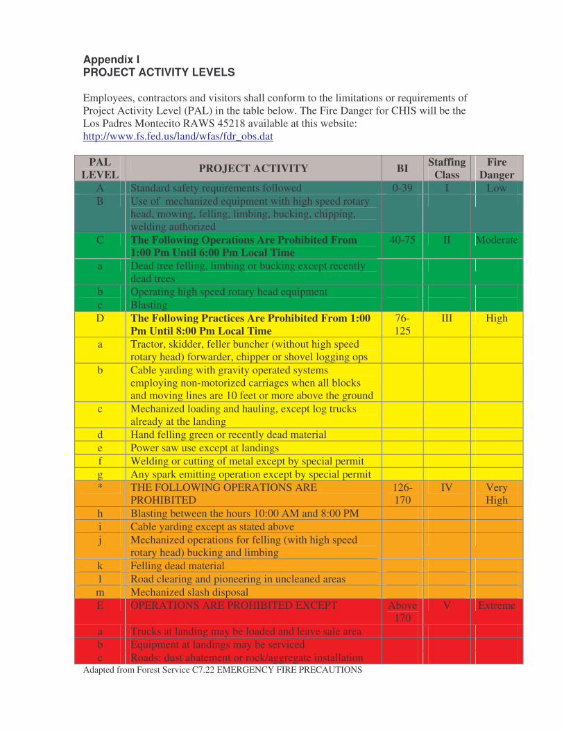
Appendix I PROJECT ACTIVITY LEVELS Employees, contractors and visitors shall conform to the limitations or requirements of Project Activity Level (PAL) in the table below. The Fire Danger for CHIS will be the Los Padres Montecito RAWS 45218 available at this website: http://www.fs.fed.us/land/wfas/fdr_obs.dat
PAL LEVEL PROJECT ACTIVITY BI Staffing
Class Fire
Danger A Standard safety requirements followed 0-39 I Low B Use of mechanized equipment with high speed rotary
head, mowing, felling, limbing, bucking, chipping, welding authorized
C The Following Operations Are Prohibited From 1:00 Pm Until 6:00 Pm Local Time
40-75 II Moderate
a Dead tree felling, limbing or bucking except recently dead trees
b Operating high speed rotary head equipment c Blasting D The Following Practices Are Prohibited From 1:00
Pm Until 8:00 Pm Local Time 76-125
III High
a Tractor, skidder, feller buncher (without high speed rotary head) forwarder, chipper or shovel logging ops
b Cable yarding with gravity operated systems employing non-motorized carriages when all blocks and moving lines are 10 feet or more above the ground
c Mechanized loading and hauling, except log trucks already at the landing
d Hand felling green or recently dead material e Power saw use except at landings f Welding or cutting of metal except by special permit g Any spark emitting operation except by special permit * THE FOLLOWING OPERATIONS ARE
PROHIBITED 126-170
IV Very High
h Blasting between the hours 10:00 AM and 8:00 PM i Cable yarding except as stated above j Mechanized operations for felling (with high speed
rotary head) bucking and limbing
k Felling dead material l Road clearing and pioneering in uncleaned areas
m Mechanized slash disposal E OPERATIONS ARE PROHIBITED EXCEPT Above
170 V Extreme
a Trucks at landing may be loaded and leave sale area b Equipment at landings may be serviced c Roads: dust abatement or rock/aggregate installation
Adapted from Forest Service C7.22 EMERGENCY FIRE PRECAUTIONS
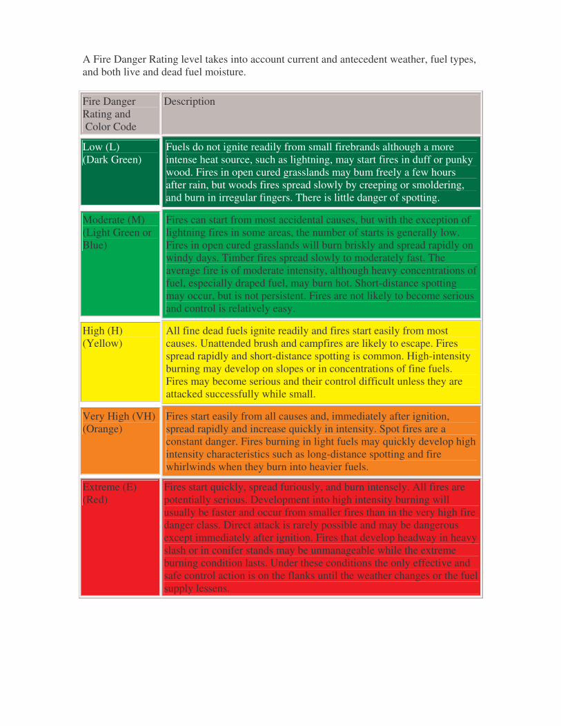
A Fire Danger Rating level takes into account current and antecedent weather, fuel types, and both live and dead fuel moisture.
Fire Danger Rating and Color Code
Description
Low (L) (Dark Green)
Fuels do not ignite readily from small firebrands although a more intense heat source, such as lightning, may start fires in duff or punky wood. Fires in open cured grasslands may bum freely a few hours after rain, but woods fires spread slowly by creeping or smoldering, and burn in irregular fingers. There is little danger of spotting.
Moderate (M) (Light Green or Blue)
Fires can start from most accidental causes, but with the exception of lightning fires in some areas, the number of starts is generally low. Fires in open cured grasslands will burn briskly and spread rapidly on windy days. Timber fires spread slowly to moderately fast. The average fire is of moderate intensity, although heavy concentrations of fuel, especially draped fuel, may burn hot. Short-distance spotting may occur, but is not persistent. Fires are not likely to become serious and control is relatively easy.
High (H) (Yellow)
All fine dead fuels ignite readily and fires start easily from most causes. Unattended brush and campfires are likely to escape. Fires spread rapidly and short-distance spotting is common. High-intensity burning may develop on slopes or in concentrations of fine fuels. Fires may become serious and their control difficult unless they are attacked successfully while small.
Very High (VH) (Orange)
Fires start easily from all causes and, immediately after ignition, spread rapidly and increase quickly in intensity. Spot fires are a constant danger. Fires burning in light fuels may quickly develop high intensity characteristics such as long-distance spotting and fire whirlwinds when they burn into heavier fuels.
Extreme (E) (Red)
Fires start quickly, spread furiously, and burn intensely. All fires are potentially serious. Development into high intensity burning will usually be faster and occur from smaller fires than in the very high fire danger class. Direct attack is rarely possible and may be dangerous except immediately after ignition. Fires that develop headway in heavy slash or in conifer stands may be unmanageable while the extreme burning condition lasts. Under these conditions the only effective and safe control action is on the flanks until the weather changes or the fuel supply lessens.