peta indeks risiko bencana gunung api / volcano … · peta indeks risiko bencana gunung api /...
TRANSCRIPT
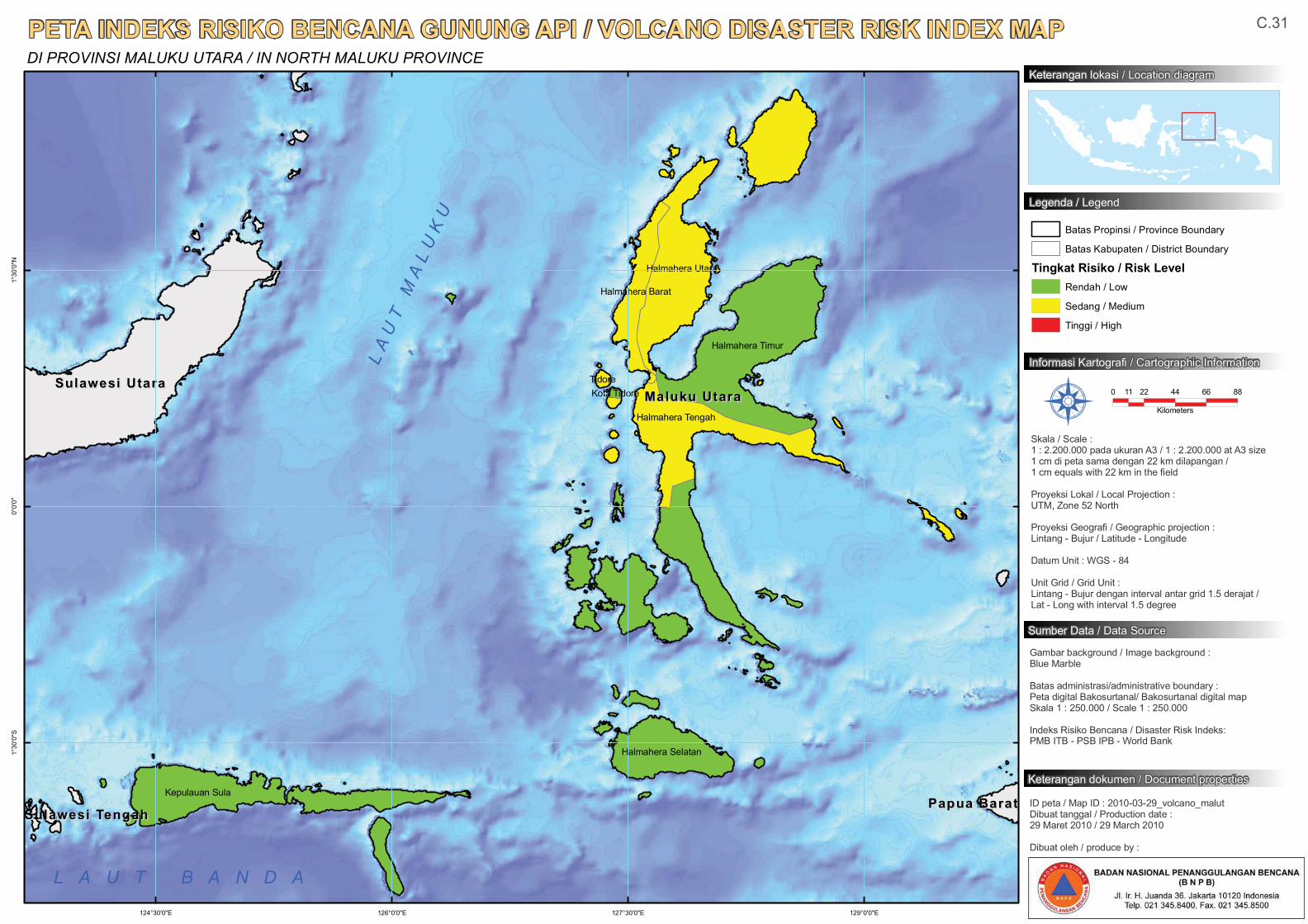
Halmahera Timur
Halmahera Tengah
Kepulauan Sula
Halmahera Selatan
Halmahera Utara
Halmahera Barat
TidoreKota Tidore Maluku UtaraMaluku Utara
Sulawesi UtaraSulawesi Utara
Papua BaratPapua BaratSulawesi TengahSulawesi Tengah
129°0'0"E127°30'0"E126°0'0"E124°30'0"E
1°30
'0"N
0°0'
0"1°
30'0
"S
PETA INDEKS RISIKO BENCANA GUNUNG API / VOLCANO DISASTER RISK INDEX MAPDI PROVINSI MALUKU UTARA / IN NORTH MALUKU PROVINCE
0 22 44 66 8811
Kilometers
Gambar background / Image background :Blue Marble
Batas administrasi/administrative boundary :Peta digital Bakosurtanal/ Bakosurtanal digital map Skala 1 : 250.000 / Scale 1 : 250.000
Indeks Risiko Bencana / Disaster Risk Indeks:PMB ITB - PSB IPB - World Bank
Informasi Kartografi / Cartographic Information
Sumber Data / Data Source
Skala / Scale :1 : 2.200.000 pada ukuran A3 / 1 : 2.200.000 at A3 size1 cm di peta sama dengan 22 km dilapangan / 1 cm equals with 22 km in the field
Proyeksi Lokal / Local Projection : UTM, Zone 52 North
Proyeksi Geografi / Geographic projection : Lintang - Bujur / Latitude - Longitude
Datum Unit : WGS - 84
Unit Grid / Grid Unit :Lintang - Bujur dengan interval antar grid 1.5 derajat / Lat - Long with interval 1.5 degree
ID peta / Map ID : 2010-03-29_volcano_malutDibuat tanggal / Production date :29 Maret 2010 / 29 March 2010
Dibuat oleh / produce by :
Å
Batas Propinsi / Province Boundary
Batas Kabupaten / District Boundary
Tingkat Risiko / Risk LevelRendah / Low
Sedang / Medium
Tinggi / High
Keterangan lokasi / Location diagram
Legenda / Legend
Keterangan dokumen / Document properties
C.31
LA
UT
MA
LU
KU
L A U T B A N D A
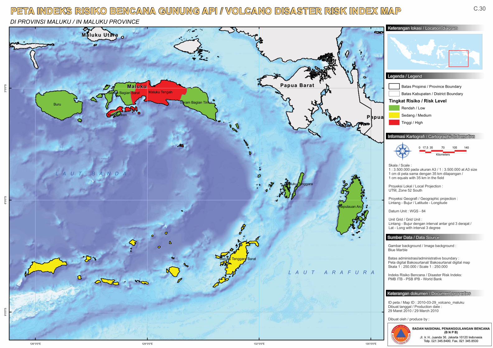
Buru
Maluku Tengah
Kepulauan Aru
Seram Bagian Timur
Seram Bagian Barat
Maluku Tenggara Barat
Maluku Tenggara
Kota Ambon
Papua BaratPapua BaratMalukuMaluku
PapuaPapua
Maluku UtaraMaluku Utara
135°0'0"E132°0'0"E129°0'0"E126°0'0"E
3°0'
0"S
6°0'
0"S
9°0'
0"S
PETA INDEKS RISIKO BENCANA GUNUNG API / VOLCANO DISASTER RISK INDEX MAPDI PROVINSI MALUKU / IN MALUKU PROVINCE
0 35 70 105 14017,5
Kilometers
Gambar background / Image background :Blue Marble
Batas administrasi/administrative boundary :Peta digital Bakosurtanal/ Bakosurtanal digital map Skala 1 : 250.000 / Scale 1 : 250.000
Indeks Risiko Bencana / Disaster Risk Indeks:PMB ITB - PSB IPB - World Bank
Informasi Kartografi / Cartographic Information
Sumber Data / Data Source
Skala / Scale :1 : 3.500.000 pada ukuran A3 / 1 : 3.500.000 at A3 size1 cm di peta sama dengan 35 km dilapangan / 1 cm equals with 35 km in the field
Proyeksi Lokal / Local Projection : UTM, Zone 52 South
Proyeksi Geografi / Geographic projection : Lintang - Bujur / Latitude - Longitude
Datum Unit : WGS - 84
Unit Grid / Grid Unit :Lintang - Bujur dengan interval antar grid 3 derajat / Lat - Long with interval 3 degree
ID peta / Map ID : 2010-03-29_volcano_malukuDibuat tanggal / Production date :29 Maret 2010 / 29 March 2010
Dibuat oleh / produce by :
Å
Batas Propinsi / Province Boundary
Batas Kabupaten / District Boundary
Tingkat Risiko / Risk LevelRendah / Low
Sedang / Medium
Tinggi / High
Keterangan lokasi / Location diagram
Legenda / Legend
Keterangan dokumen / Document properties
C.30
L A U T A R A F U R A
L A U T B A N D A
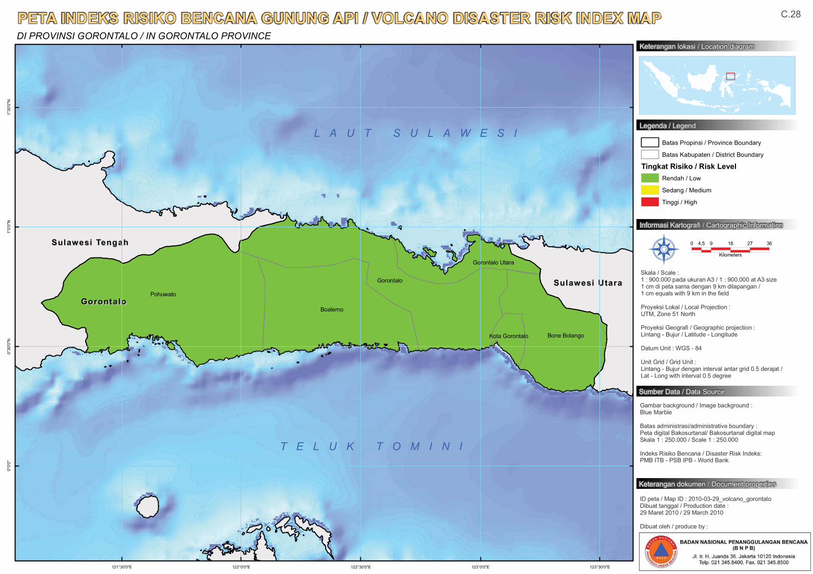
Pohuwato
Gorontalo
Boalemo
Bone Bolango
Gorontalo Utara
Kota Gorontalo
GorontaloGorontalo
Sulawesi TengahSulawesi Tengah
Sulawesi UtaraSulawesi Utara
123°30'0"E123°0'0"E122°30'0"E122°0'0"E121°30'0"E
1°30
'0"N
1°0'
0"N
0°30
'0"N
0°0'
0"
PETA INDEKS RISIKO BENCANA GUNUNG API / VOLCANO DISASTER RISK INDEX MAPDI PROVINSI GORONTALO / IN GORONTALO PROVINCE
0 9 18 27 364,5
Kilometers
Gambar background / Image background :Blue Marble
Batas administrasi/administrative boundary :Peta digital Bakosurtanal/ Bakosurtanal digital map Skala 1 : 250.000 / Scale 1 : 250.000
Indeks Risiko Bencana / Disaster Risk Indeks:PMB ITB - PSB IPB - World Bank
Informasi Kartografi / Cartographic Information
Sumber Data / Data Source
Skala / Scale :1 : 900.000 pada ukuran A3 / 1 : 900.000 at A3 size1 cm di peta sama dengan 9 km dilapangan / 1 cm equals with 9 km in the field
Proyeksi Lokal / Local Projection : UTM, Zone 51 North
Proyeksi Geografi / Geographic projection : Lintang - Bujur / Latitude - Longitude
Datum Unit : WGS - 84
Unit Grid / Grid Unit :Lintang - Bujur dengan interval antar grid 0.5 derajat / Lat - Long with interval 0.5 degree
ID peta / Map ID : 2010-03-29_volcano_gorontaloDibuat tanggal / Production date :29 Maret 2010 / 29 March 2010
Dibuat oleh / produce by :
Å
Batas Propinsi / Province Boundary
Batas Kabupaten / District Boundary
Tingkat Risiko / Risk LevelRendah / Low
Sedang / Medium
Tinggi / High
Keterangan lokasi / Location diagram
Legenda / Legend
Keterangan dokumen / Document properties
C.28
T E L U K T O M I N I
L A U T S U L A W E S I
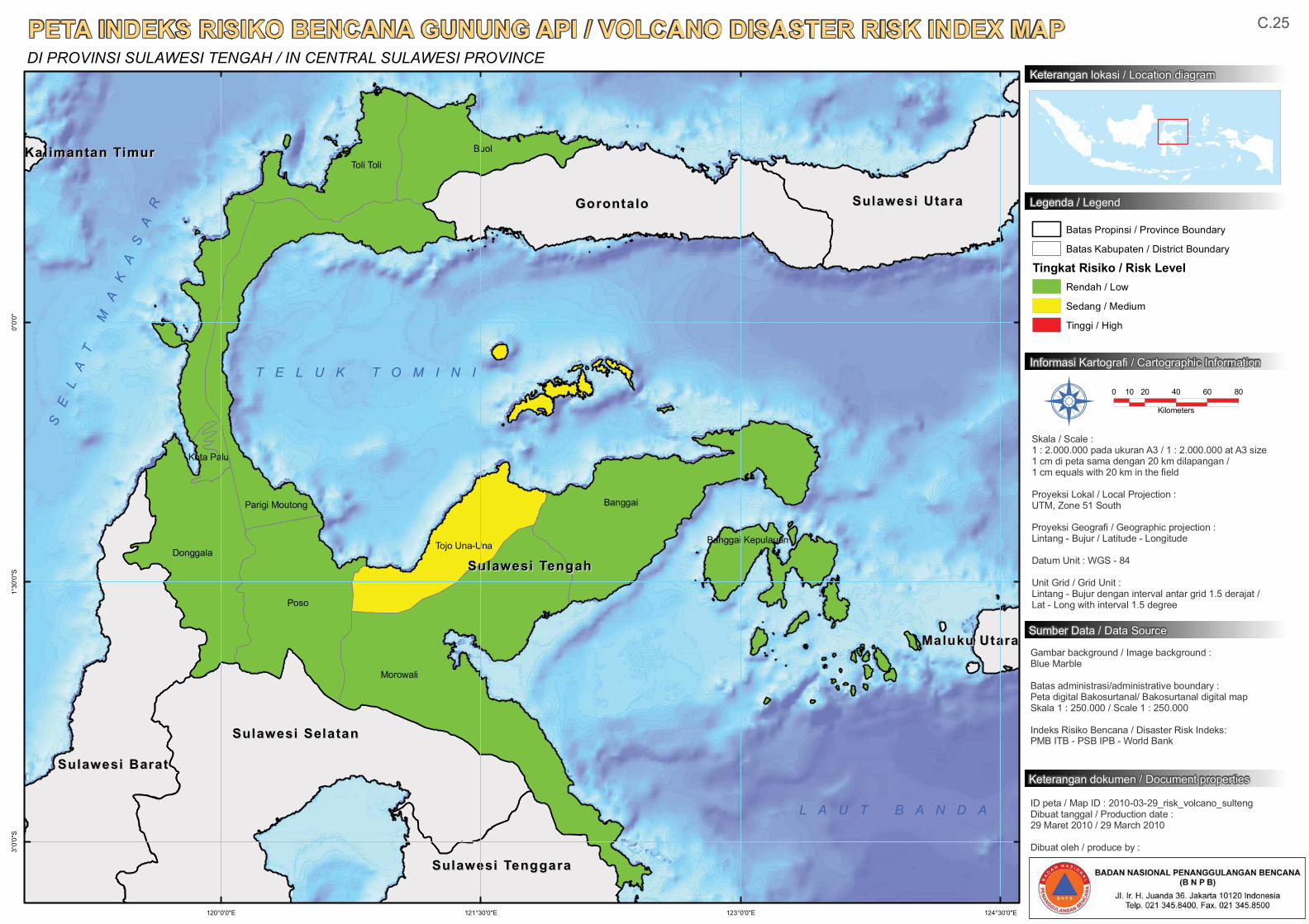
Morowali
Poso
Banggai
Buol
Donggala
Toli Toli
Parigi Moutong
Tojo Una-Una Banggai Kepulauan
Kota Palu
Sulawesi TengahSulawesi Tengah
Sulawesi SelatanSulawesi Selatan
GorontaloGorontalo
Sulawesi BaratSulawesi Barat
Sulawesi UtaraSulawesi Utara
Sulawesi TenggaraSulawesi Tenggara
Maluku UtaraMaluku Utara
Kalimantan TimurKalimantan Timur
124°30'0"E123°0'0"E121°30'0"E120°0'0"E
0°0'
0"1°
30'0
"S3°
0'0"
S
PETA INDEKS RISIKO BENCANA GUNUNG API / VOLCANO DISASTER RISK INDEX MAPDI PROVINSI SULAWESI TENGAH / IN CENTRAL SULAWESI PROVINCE
0 20 40 60 8010
Kilometers
Gambar background / Image background :Blue Marble
Batas administrasi/administrative boundary :Peta digital Bakosurtanal/ Bakosurtanal digital map Skala 1 : 250.000 / Scale 1 : 250.000
Indeks Risiko Bencana / Disaster Risk Indeks:PMB ITB - PSB IPB - World Bank
Informasi Kartografi / Cartographic Information
Sumber Data / Data Source
Skala / Scale :1 : 2.000.000 pada ukuran A3 / 1 : 2.000.000 at A3 size1 cm di peta sama dengan 20 km dilapangan / 1 cm equals with 20 km in the field
Proyeksi Lokal / Local Projection : UTM, Zone 51 South
Proyeksi Geografi / Geographic projection : Lintang - Bujur / Latitude - Longitude
Datum Unit : WGS - 84
Unit Grid / Grid Unit :Lintang - Bujur dengan interval antar grid 1.5 derajat / Lat - Long with interval 1.5 degree
ID peta / Map ID : 2010-03-29_risk_volcano_sultengDibuat tanggal / Production date :29 Maret 2010 / 29 March 2010
Dibuat oleh / produce by :
Å
Batas Propinsi / Province Boundary
Batas Kabupaten / District Boundary
Tingkat Risiko / Risk LevelRendah / Low
Sedang / Medium
Tinggi / High
Keterangan lokasi / Location diagram
Legenda / Legend
Keterangan dokumen / Document properties
C.25
T E L U K T O M I N I
L A U T B A N D A
SE
LA
TM
AK
AS
AR
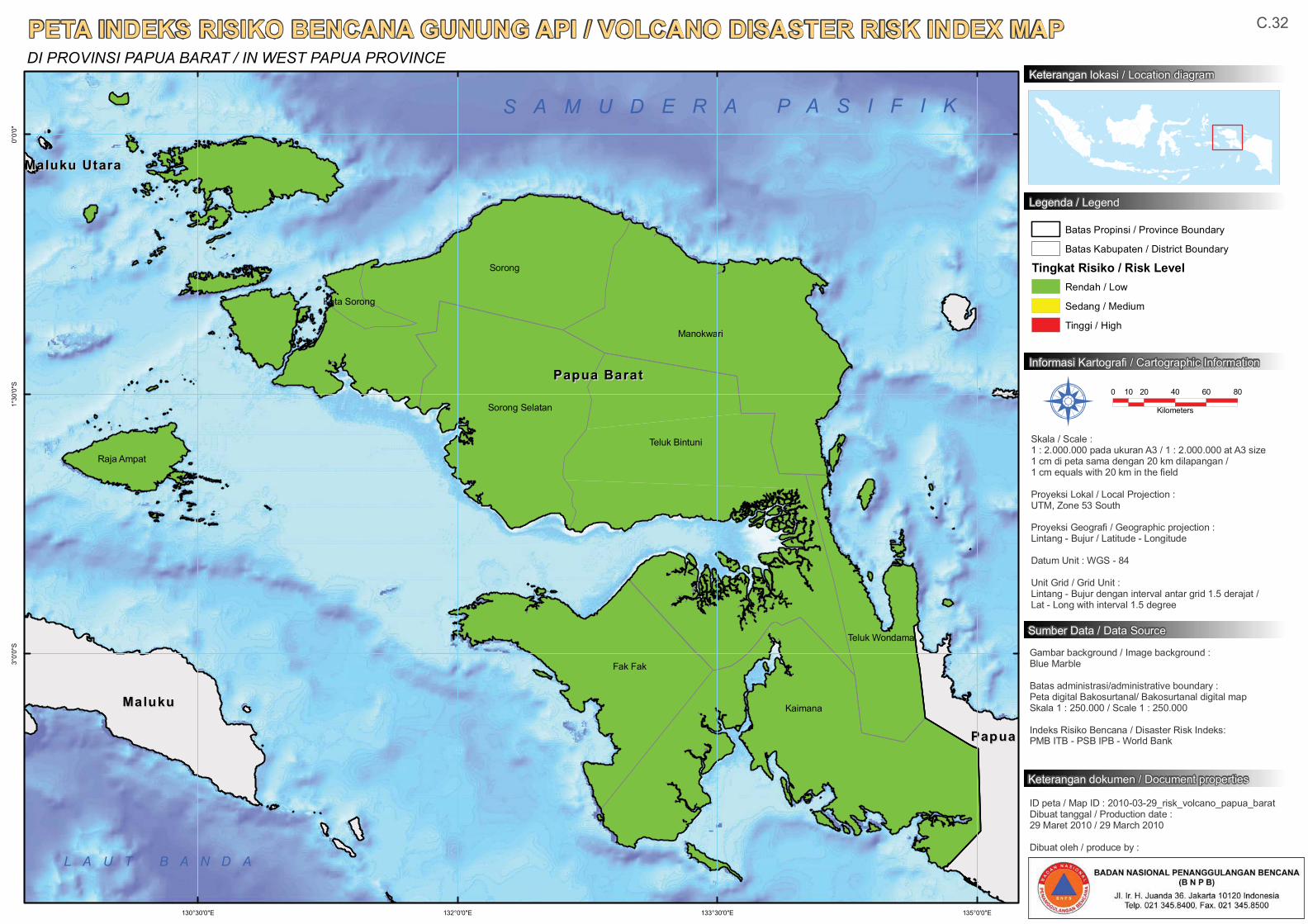
Kaimana
Sorong
Teluk Bintuni
Manokwari
Fak Fak
Sorong Selatan
Raja Ampat
Teluk Wondama
Kota Sorong
Papua BaratPapua Barat
MalukuMaluku
PapuaPapua
Maluku UtaraMaluku Utara
135°0'0"E133°30'0"E132°0'0"E130°30'0"E
0°0'
0"1°
30'0
"S3°
0'0"
S
PETA INDEKS RISIKO BENCANA GUNUNG API / VOLCANO DISASTER RISK INDEX MAPDI PROVINSI PAPUA BARAT / IN WEST PAPUA PROVINCE
0 20 40 60 8010
Kilometers
Gambar background / Image background :Blue Marble
Batas administrasi/administrative boundary :Peta digital Bakosurtanal/ Bakosurtanal digital map Skala 1 : 250.000 / Scale 1 : 250.000
Indeks Risiko Bencana / Disaster Risk Indeks:PMB ITB - PSB IPB - World Bank
Informasi Kartografi / Cartographic Information
Sumber Data / Data Source
Skala / Scale :1 : 2.000.000 pada ukuran A3 / 1 : 2.000.000 at A3 size1 cm di peta sama dengan 20 km dilapangan / 1 cm equals with 20 km in the field
Proyeksi Lokal / Local Projection : UTM, Zone 53 South
Proyeksi Geografi / Geographic projection : Lintang - Bujur / Latitude - Longitude
Datum Unit : WGS - 84
Unit Grid / Grid Unit :Lintang - Bujur dengan interval antar grid 1.5 derajat / Lat - Long with interval 1.5 degree
ID peta / Map ID : 2010-03-29_risk_volcano_papua_baratDibuat tanggal / Production date :29 Maret 2010 / 29 March 2010
Dibuat oleh / produce by :
Å
Batas Propinsi / Province Boundary
Batas Kabupaten / District Boundary
Tingkat Risiko / Risk LevelRendah / Low
Sedang / Medium
Tinggi / High
Keterangan lokasi / Location diagram
Legenda / Legend
Keterangan dokumen / Document properties
C.32
S A M U D E R A P A S I F I K
L A U T B A N D A
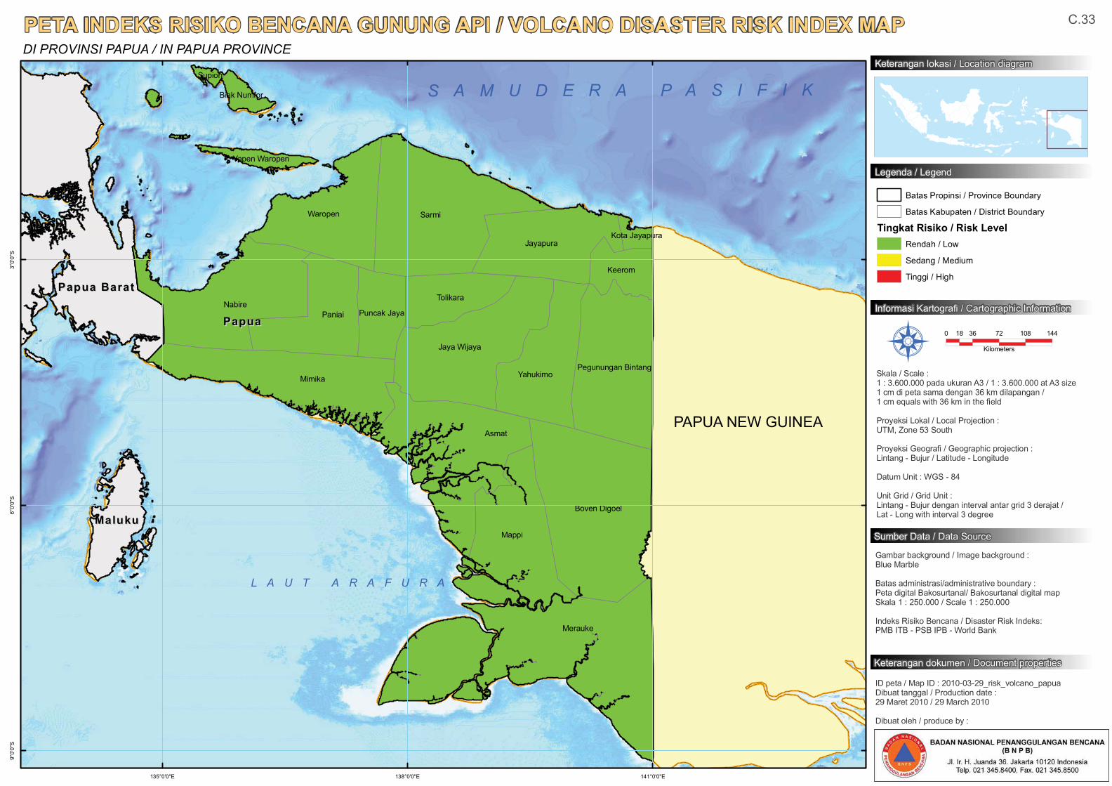
Sarmi
Merauke
Nabire
Mimika
Mappi
Asmat
Boven Digoel
Paniai
Waropen
Jaya Wijaya
Jayapura
Yahukimo
Tolikara
Pegunungan Bintang
Keerom
Puncak Jaya
Biak Numfor
Yapen Waropen
Kota Jayapura
Supiori
PapuaPapua
Papua BaratPapua Barat
MalukuMaluku
141°0'0"E138°0'0"E135°0'0"E
3°0'
0"S
6°0'
0"S
9°0'
0"S
PETA INDEKS RISIKO BENCANA GUNUNG API / VOLCANO DISASTER RISK INDEX MAPDI PROVINSI PAPUA / IN PAPUA PROVINCE
0 36 72 108 14418
Kilometers
Gambar background / Image background :Blue Marble
Batas administrasi/administrative boundary :Peta digital Bakosurtanal/ Bakosurtanal digital map Skala 1 : 250.000 / Scale 1 : 250.000
Indeks Risiko Bencana / Disaster Risk Indeks:PMB ITB - PSB IPB - World Bank
Informasi Kartografi / Cartographic Information
Sumber Data / Data Source
Skala / Scale :1 : 3.600.000 pada ukuran A3 / 1 : 3.600.000 at A3 size1 cm di peta sama dengan 36 km dilapangan / 1 cm equals with 36 km in the field
Proyeksi Lokal / Local Projection : UTM, Zone 53 South
Proyeksi Geografi / Geographic projection : Lintang - Bujur / Latitude - Longitude
Datum Unit : WGS - 84
Unit Grid / Grid Unit :Lintang - Bujur dengan interval antar grid 3 derajat / Lat - Long with interval 3 degree
ID peta / Map ID : 2010-03-29_risk_volcano_papuaDibuat tanggal / Production date :29 Maret 2010 / 29 March 2010
Dibuat oleh / produce by :
Å
Batas Propinsi / Province Boundary
Batas Kabupaten / District Boundary
Tingkat Risiko / Risk LevelRendah / Low
Sedang / Medium
Tinggi / High
Keterangan lokasi / Location diagram
Legenda / Legend
Keterangan dokumen / Document properties
C.33
L A U T A R A F U R A
S A M U D E R A P A S I F I K
PAPUA NEW GUINEA
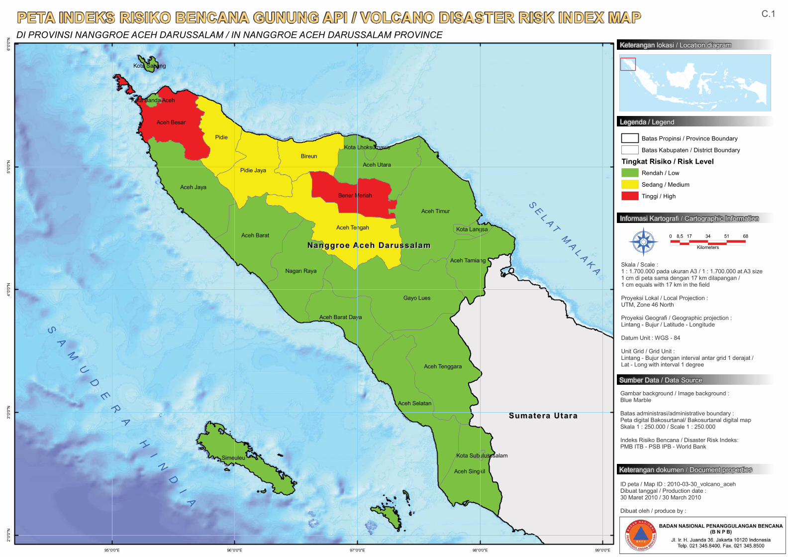
Gayo Lues
Aceh Timur
Pidie
Aceh Jaya
Aceh TengahAceh Barat
Aceh Tenggara
Bireun
Pidie Jaya
Aceh Selatan
Nagan Raya
Aceh Besar
Aceh Utara
Aceh Singkil
Simeuleu
Aceh Tamiang
Bener Meriah
Aceh Barat Daya
Kota Langsa
Kota Lhoksumawe
Kota Sabang
Kota Banda Aceh
Kota Subulusssalam
Nanggroe Aceh DarussalamNanggroe Aceh Darussalam
Sumatera UtaraSumatera Utara
99°0'0"E98°0'0"E97°0'0"E96°0'0"E95°0'0"E
6°0'
0"N
5°0'
0"N
4°0'
0"N
3°0'
0"N
2°0'
0"N
PETA INDEKS RISIKO BENCANA GUNUNG API / VOLCANO DISASTER RISK INDEX MAPDI PROVINSI NANGGROE ACEH DARUSSALAM / IN NANGGROE ACEH DARUSSALAM PROVINCE
0 17 34 51 688,5
Kilometers
Gambar background / Image background :Blue Marble
Batas administrasi/administrative boundary :Peta digital Bakosurtanal/ Bakosurtanal digital map Skala 1 : 250.000 / Scale 1 : 250.000
Indeks Risiko Bencana / Disaster Risk Indeks:PMB ITB - PSB IPB - World Bank
Informasi Kartografi / Cartographic Information
Sumber Data / Data Source
Skala / Scale :1 : 1.700.000 pada ukuran A3 / 1 : 1.700.000 at A3 size1 cm di peta sama dengan 17 km dilapangan / 1 cm equals with 17 km in the field
Proyeksi Lokal / Local Projection : UTM, Zone 46 North
Proyeksi Geografi / Geographic projection : Lintang - Bujur / Latitude - Longitude
Datum Unit : WGS - 84
Unit Grid / Grid Unit :Lintang - Bujur dengan interval antar grid 1 derajat / Lat - Long with interval 1 degree
ID peta / Map ID : 2010-03-30_volcano_acehDibuat tanggal / Production date :30 Maret 2010 / 30 March 2010
Dibuat oleh / produce by :
Å
Batas Propinsi / Province Boundary
Batas Kabupaten / District Boundary
Tingkat Risiko / Risk LevelRendah / Low
Sedang / Medium
Tinggi / High
Keterangan lokasi / Location diagram
Legenda / Legend
Keterangan dokumen / Document properties
C.1
SE
L A TM
AL A
KA
SA
MU
DE
RA
HI
ND
IA
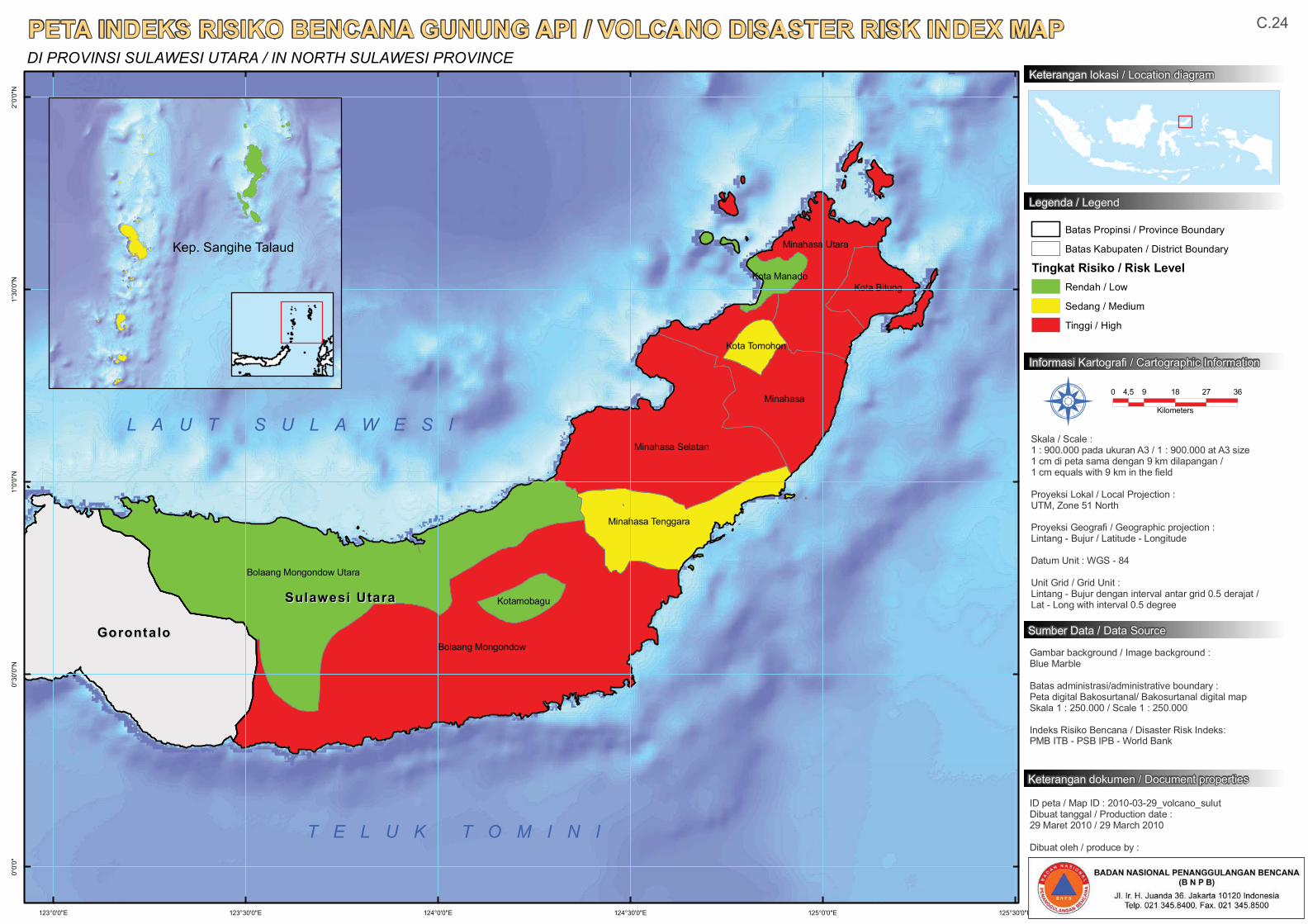
Bolaang Mongondow
Bolaang Mongondow Utara
Minahasa
Minahasa Selatan
Minahasa Utara
Minahasa Tenggara
Kota Bitung
Kotamobagu
Kota Tomohon
Kota Manado
Sulawesi UtaraSulawesi Utara
GorontaloGorontalo
125°30'0"E125°0'0"E124°30'0"E124°0'0"E123°30'0"E123°0'0"E
2°0'
0"N
1°30
'0"N
1°0'
0"N
0°30
'0"N
0°0'
0"
PETA INDEKS RISIKO BENCANA GUNUNG API / VOLCANO DISASTER RISK INDEX MAPDI PROVINSI SULAWESI UTARA / IN NORTH SULAWESI PROVINCE
0 9 18 27 364,5
Kilometers
Gambar background / Image background :Blue Marble
Batas administrasi/administrative boundary :Peta digital Bakosurtanal/ Bakosurtanal digital map Skala 1 : 250.000 / Scale 1 : 250.000
Indeks Risiko Bencana / Disaster Risk Indeks:PMB ITB - PSB IPB - World Bank
Informasi Kartografi / Cartographic Information
Sumber Data / Data Source
Skala / Scale :1 : 900.000 pada ukuran A3 / 1 : 900.000 at A3 size1 cm di peta sama dengan 9 km dilapangan / 1 cm equals with 9 km in the field
Proyeksi Lokal / Local Projection : UTM, Zone 51 North
Proyeksi Geografi / Geographic projection : Lintang - Bujur / Latitude - Longitude
Datum Unit : WGS - 84
Unit Grid / Grid Unit :Lintang - Bujur dengan interval antar grid 0.5 derajat / Lat - Long with interval 0.5 degree
ID peta / Map ID : 2010-03-29_volcano_sulutDibuat tanggal / Production date :29 Maret 2010 / 29 March 2010
Dibuat oleh / produce by :
Å
Batas Propinsi / Province Boundary
Batas Kabupaten / District Boundary
Tingkat Risiko / Risk LevelRendah / Low
Sedang / Medium
Tinggi / High
Keterangan lokasi / Location diagram
Legenda / Legend
Keterangan dokumen / Document properties
C.24
T E L U K T O M I N I
Kep. Sangihe Talaud
L A U T S U L A W E S I
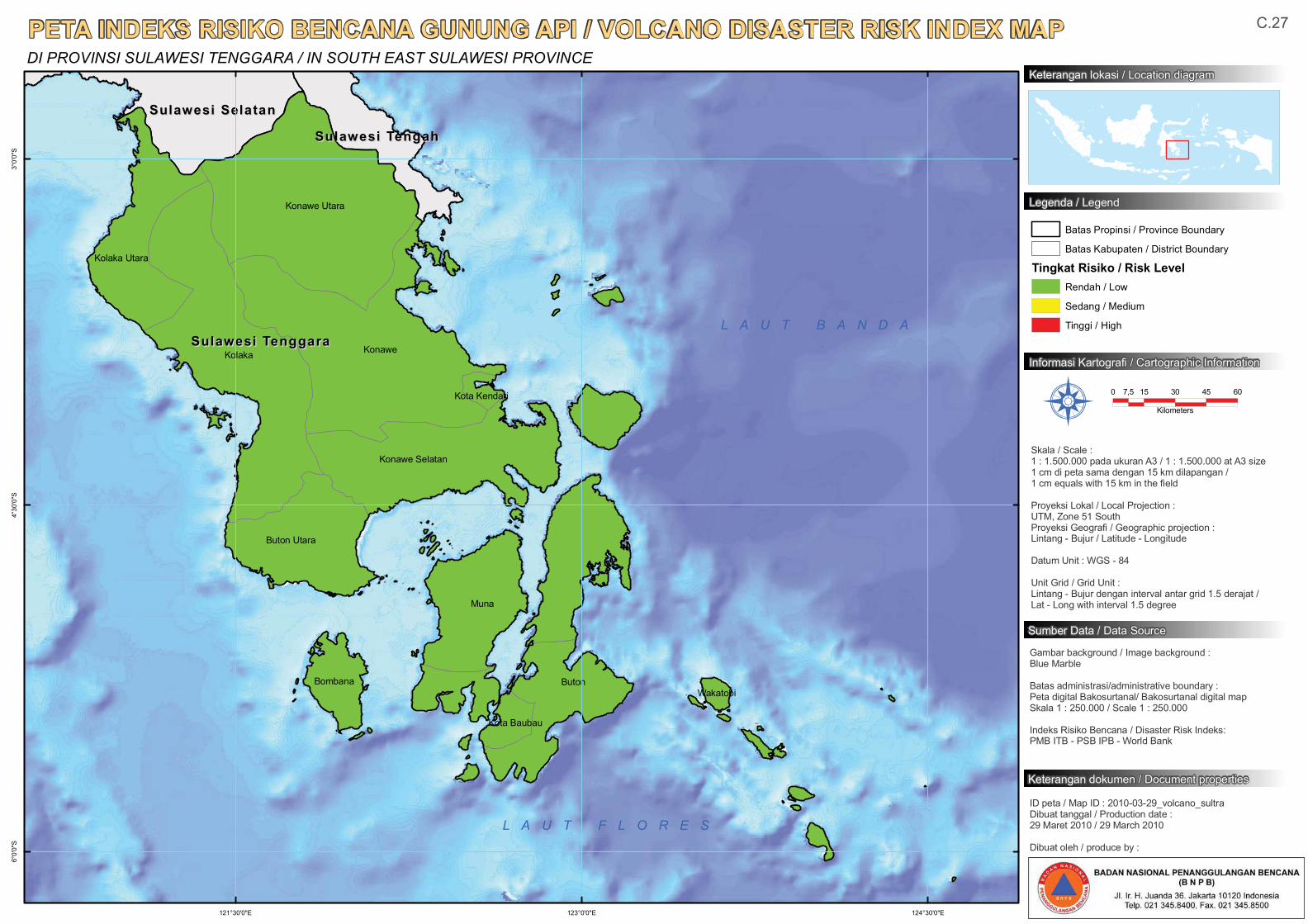
Kolaka Konawe
Konawe Utara
Muna
Buton
Konawe Selatan
Buton Utara
Kolaka Utara
Bombana
Kota Baubau
Wakatobi
Kota Kendari
Sulawesi TenggaraSulawesi Tenggara
Sulawesi SelatanSulawesi Selatan
Sulawesi TengahSulawesi Tengah
124°30'0"E123°0'0"E121°30'0"E
3°0'
0"S
4°30
'0"S
6°0'
0"S
PETA INDEKS RISIKO BENCANA GUNUNG API / VOLCANO DISASTER RISK INDEX MAPDI PROVINSI SULAWESI TENGGARA / IN SOUTH EAST SULAWESI PROVINCE
0 15 30 45 607,5
Kilometers
Gambar background / Image background :Blue Marble
Batas administrasi/administrative boundary :Peta digital Bakosurtanal/ Bakosurtanal digital map Skala 1 : 250.000 / Scale 1 : 250.000
Indeks Risiko Bencana / Disaster Risk Indeks:PMB ITB - PSB IPB - World Bank
Informasi Kartografi / Cartographic Information
Sumber Data / Data Source
Skala / Scale :1 : 1.500.000 pada ukuran A3 / 1 : 1.500.000 at A3 size1 cm di peta sama dengan 15 km dilapangan / 1 cm equals with 15 km in the field
Proyeksi Lokal / Local Projection : UTM, Zone 51 SouthProyeksi Geografi / Geographic projection : Lintang - Bujur / Latitude - Longitude
Datum Unit : WGS - 84
Unit Grid / Grid Unit :Lintang - Bujur dengan interval antar grid 1.5 derajat / Lat - Long with interval 1.5 degree
ID peta / Map ID : 2010-03-29_volcano_sultraDibuat tanggal / Production date :29 Maret 2010 / 29 March 2010
Dibuat oleh / produce by :
Å
Batas Propinsi / Province Boundary
Batas Kabupaten / District Boundary
Tingkat Risiko / Risk LevelRendah / Low
Sedang / Medium
Tinggi / High
Keterangan lokasi / Location diagram
Legenda / Legend
Keterangan dokumen / Document properties
C.27
L A U T B A N D A
L A U T F L O R E S
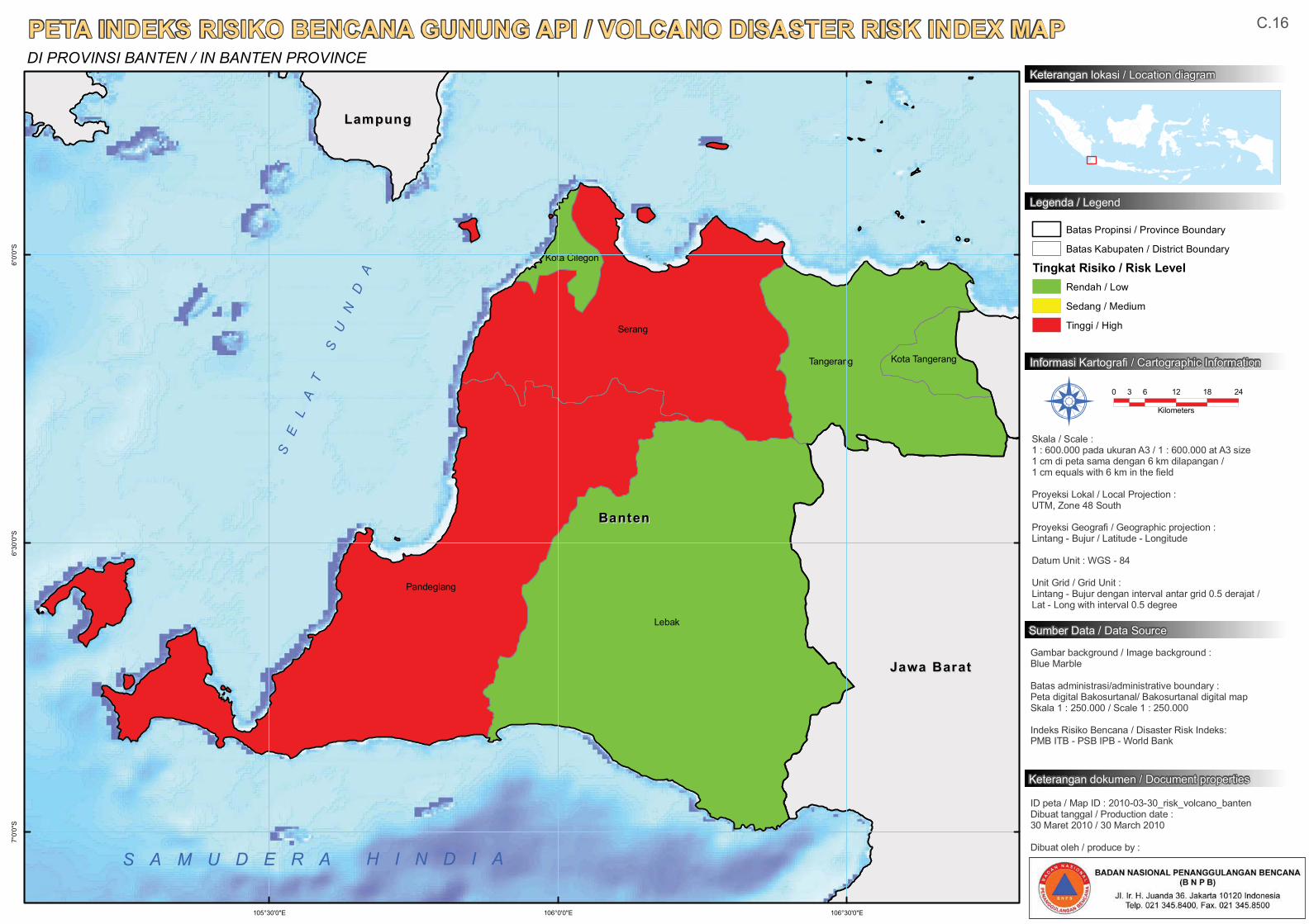
Lebak
Serang
Pandeglang
Tangerang Kota Tangerang
Kota Cilegon
BantenBanten
Jawa BaratJawa Barat
LampungLampung
106°30'0"E106°0'0"E105°30'0"E
6°0'
0"S
6°30
'0"S
7°0'
0"S
PETA INDEKS RISIKO BENCANA GUNUNG API / VOLCANO DISASTER RISK INDEX MAPDI PROVINSI BANTEN / IN BANTEN PROVINCE
0 6 12 18 243
Kilometers
Gambar background / Image background :Blue Marble
Batas administrasi/administrative boundary :Peta digital Bakosurtanal/ Bakosurtanal digital map Skala 1 : 250.000 / Scale 1 : 250.000
Indeks Risiko Bencana / Disaster Risk Indeks:PMB ITB - PSB IPB - World Bank
Informasi Kartografi / Cartographic Information
Sumber Data / Data Source
Skala / Scale :1 : 600.000 pada ukuran A3 / 1 : 600.000 at A3 size1 cm di peta sama dengan 6 km dilapangan / 1 cm equals with 6 km in the field
Proyeksi Lokal / Local Projection : UTM, Zone 48 South
Proyeksi Geografi / Geographic projection : Lintang - Bujur / Latitude - Longitude
Datum Unit : WGS - 84
Unit Grid / Grid Unit :Lintang - Bujur dengan interval antar grid 0.5 derajat / Lat - Long with interval 0.5 degree
ID peta / Map ID : 2010-03-30_risk_volcano_bantenDibuat tanggal / Production date :30 Maret 2010 / 30 March 2010
Dibuat oleh / produce by :
Å
Batas Propinsi / Province Boundary
Batas Kabupaten / District Boundary
Tingkat Risiko / Risk LevelRendah / Low
Sedang / Medium
Tinggi / High
Keterangan lokasi / Location diagram
Legenda / Legend
Keterangan dokumen / Document properties
S A M U D E R A H I N D I A
C.16
SE
LA
TS
UN
DA