kementerian perhubungan direktorat jenderal...
TRANSCRIPT

lb. Terkait ...
2. Mengalir dari butir 1 (satu) diatas, mengingat Direktorat Kenavigasian dan Distrik Navigasi mempunyai tugas pokok dan fungsi untuk menyusun dan menyebarkan maklumat pelayaran I navigational warnings, bersama ini disampaikan beberapa hal sebagai berikut:
a. Dalam rangka mempercepat penyebaran informasi terkait dengan bahaya pelayaran dan informasi-informasi lainnya yang terkait dengan keselamatan pelayaran di sekitarwilayah kerja masing-masing Distrik Navigasi, kiranya setelah menerima informasi mengenai bahaya pelayaran dari sumber yang dapat dipercaya, setiap Distrik Navigasi agar segera menyusun dan menyebarkan maklumat pelayaran I navigational warnings melalui Stasiun Radio Pantai dan/atau Vessel Traffic Setvlces (VTS) di wilayah kerja Saudara, serta mengirimkan juga informasi dimaksud kepada Direktorat Kenavigasian-Direktorat Jenderal Perhubungan Laut untuk disebarluaskan kembali ke wilayah Indonesia lainnya, melalui stasiun NA VTEX, Stasiun Radio Pantai dan VTS;
1. Menunjuk:
a. Peraturan Pemerintah No. 5 Tahun 2010 tentang Kenavigasian;
b. Peraturan Menteri Perhubungan No. PM 25 Tahun 2011 tentang Sarana Bantu Navigasi - Pelayaran;
c. Peraturan Menteri Perhubungan No. PM 26 Tahun 2011 tentang Telekomunikasi - Pelayaran;
d. Peraturan Menteri Perhubungan No. PM 129 Tahun 2016 tentang Alur Pelayaran di Laut dan Bangunan dan/atau lnstalasi di Perairan;
e. Chapter V Regulation 4 of the International Convention for the Safety of Life at Sea, 1974 Mengenai Navigational Warnings;
f. Chapter V Regulation 13 of the International Convention for the Safety of Life at Sea, 1974 Mengenai Establishment and Operation of Aids to Navigation;
g. International Maritime Organization (IMO) Circular No. MSC.1/Circ.1310 dated 8 June 2009 Concerning the Revised Joint IMOllHOIWMO Manual Maritime Safety Information (MSI).
Yth. 1. Para Kadisnav Kelas I; 2. Para Kadisnav Kelas II; dan 3. Para Kadisnav Kelas Ill.
di
TEMPAT
Ke pad a Standar Penggunaan lstilah Dalam Maklumat Pelayaran I Navigational Warnings Serta Pembuatan Quick Response Maklumat Pelayaran I Navigational Warnings
Jakarta, t.) September 2017
j Model Takah 02 j
Nomor Klasifikasi Lampi ran Peri ha I
JL. MEDAN MERDEKA BARAT No. 81 TEL : 3811308, 3505006. 3813269, 344 7017 I TLX . 3844492, 3458540 3842440
JAKARTA-10110 PST. 4213,4227.4209.4135 FAX: 3811786,3845430.3507576
KEMENTERIAN PERHUBUNGAN DIREKTORAT JENDERAL PERHUBUNGAN LAUT
GEDUNG KARYA LANTAI 12 S.D 17
··1r\NYOMAN S KAYADNYA MM. Pembina Uta a Muda (IV/c) NIP. 19600914 198403 1 002
L PERHUBUNGAN LAUT VIGASIAN
Tembusan: 1. Direktur Jenderal Perhubungan Laut; 2. Sekretaris Direktorat Jenderal Perhubungan Laut; 3. Para Kepala Sub Direktorat di lingkungan Direktorat
Kenavigasian.
4. Demikian disampaikan, atas perhatiannya diucapkan terima kasih.
3. Sehubungan dengan hal tersebut diatas, mengingat pentingnya informasi yang terkait dengan bahaya navigasi dan SBNP dimaksud, serta dalam rangka meningkatkan pelayanan dan efektivitas dalam proses penyampaian informasi dari Distrik Navigasi terkait dengan hal-hal tersebut diatas, kiranya dalam pembuatan Maklumat Pelayaran yang digunakan untuk sekitar wilayah kerja Distrik Navigasi dapat menggunakan standar penggunaan istilah dalam maklumat pelayaran I navigational warning sesuai dengan standar yang diatur oleh IMO dan The International Association of Marine Aids to Navigation and Lighthouse Authorities (IALA) sebagaimana terlampir. Lebih lanjut untuk mempercepat proses penyampaian informasi, selain disampaikan melalui jalur resmi, kiranya informasi dimaksud dapat disampaikan melalui jalur quick response Maklumat pelayaran, yaitu:
Alamat Surat Elektronik (Email) : [email protected]
Concact Person : Oktima Wuryantari I 081325366466
Diana Siahaan I 085360181124
Adapun standar penggunaan istilah dalam maklumat pelayaran I navigational warnings sesuai dengan standar yang diatur oleh IMO dan IALA, dapat diunduh pada www.outlook.com, dengan email sebagai berikut:
Email : [email protected]
Password : disnav25
b. Terkait dengan pengoperasian Sarana Bantu Navigasi Pelayaran (SBNP), apabila terdapat kerusakan dan/atau hambatan pada SBNP di wilayah kerja Distrik, kiranya setelah menerima laporan atas kerusakan dan/atau hambatan pada SBNP dimaksud, setiap Distrik Navigasi agar segera menyusun dan menyebarkan maklumat pelayaran I navigational warnings melalui Stasiun Radio Pantai dan/atau VTS di wilayah kerja Saudara serta mengirimkan juga informasi dimaksud kepada Direktorat Kenavigasian-Direktorat Jenderal Perhubungan Laut untuk disebarluaskan kembali ke wilayah Indonesia lainnya, melalui stasiun NAVTEX, Stasiun Radio Pantai dan VTS;
c. Lebih lanjut apabila SBNP yang sebelumnya dalam keadaaan rusak dan/atau terdapat hambatan, telah dapat beroperasi dengan normal, kiranya setelah menerima laporan resmi mengenai beroperasinya SBNP dimaksud, setiap Distrik Navigasi agar segera menyusun dan menyebarkan maklumat pelayaran I navigational warnings melalui Stasiun Radio Pantai I VTS di wilayah kerja Saudara serta mengirimkan juga informasi dimaksud kepada Direktorat Kenavigasian-Direktorat Jenderal Perhubungan Laut untuk disebarluaskan kembali ke wilayah Indonesia lainnya, melalui stasiun NA VTEX, Stasiun Radio Pantai dan VTS.
J:\CJRC\MSC\01\13 IO.doc
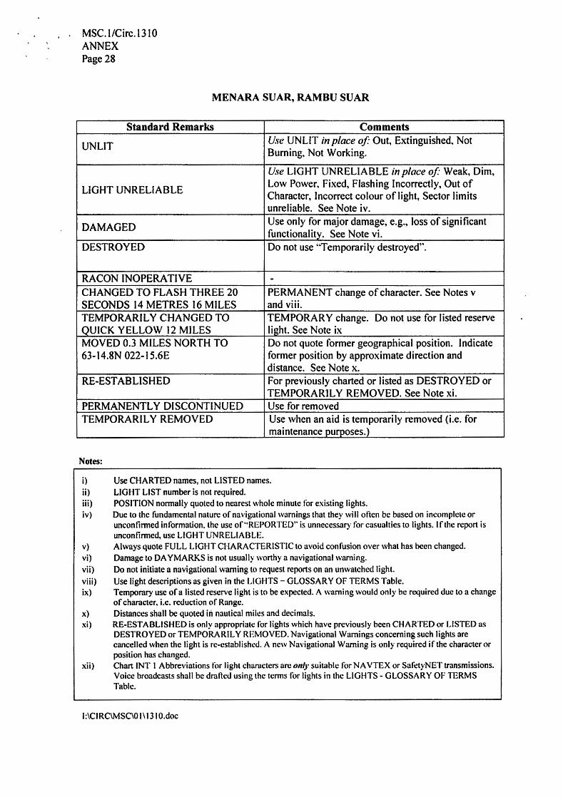
i) Use CHARTED names, not LISTED names. ii) LIGHT LIST number is not required. iii) POSITION normally quoted to nearest whole minute for existing lights. iv) Due to the fundamental nature of navigational warnings that they will often be based on incomplete or
unconfinncd information, the use of "REPORTED'' is unnecessary for casualties to lights. If the report is unconfirmed, use LIGHT UNRELIABLE.
v) Always quote FULL LIGHT CHARACTERlSTlC to avoid confusion over what has been changed. vi) Damage to DA YMARKS is not usually worthy a navigational warning. vii) Do not initiate a navigational warning to request reports on an unwatched light. viii) Use light descriptions as given in the LIGHTS - GLOSSARY OF TERMS Table. ix) Temporary use of a listed reserve light is to be expected. A warning would only be required due to a change
of character. i.e. reduction of Range. x) Distances shall be quoted in nautical miles and decimals. xi) RE-ESTABLISHED is only appropriate for lights which have previously been CHARTED or LISTED as
DESTROYED or TEMPORARILY REMOVED. Navigational Warnings concerning such lights are cancelled when the light is re-established. A new Navigational Warning is only required if the character or position has changed.
xii) Chart INT I Abbreviations for light characters arc 011/y suitable for NA VTEX or SafetyNET transmissions. Voice broadcasts shall be drafted using the terms for lights in the LIGHTS- GLOSSARY OF TERMS Table.
Notes:
Standard Remarks Comments
UNLIT Use UNLIT in place of· Out, Extinguished, Not Burning, Not Working. Use LIGHT UNRELIABLE in place of" Weak, Dim,
LIGHT UNRELIABLE Low Power, Fixed, Flashing Incorrectly, Out of Character, Incorrect colour of light, Sector limits unreliable. See Note iv.
DAMAGED Use only for major damage, e.g., loss of significant functionality. See Note vi.
DESTROYED Do not use "Temporarily destroyed".
RA CON INOPERATIVE - CHANGED TO FLASH THREE 20 PERMANENT change of character. See Notes v SECONDS 14 METRES 16 MILES and viii. TEMPORARILY CHANGED TO TEMPORARY change. Do not use for listed reserve QUICK YELLOW 12 MILES light. See Note ix MOVED 0.3 MILES NORTH TO Do not quote former geographical position. Indicate 63-14.SN 022- l 5.6E former position by approximate direction and
distance. See Note x. RE-ESTABLISHED For previously charted or listed as DESTROYED or
TEMPORARILY REMOVED. See Note xi. PERMANENTLY DISCONTINUED Use for removed TEMPORARILY REMOVED Use when an aid is temporarily removed (i.e. for
maintenance purposes.)
MENARASUAR,RAMBUSUAR
MSC. l/Circ.13 IO ANNEX Page 28
l:\CIRC\MSC\O I\ 131 O.doc
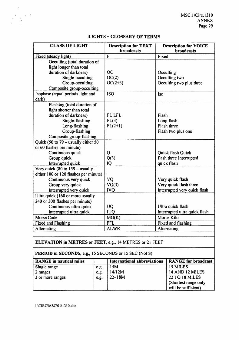
CLASS OF LIGHT Description for TEXT Description for VOICE broadcasts broadcasts
Fixed (steady tight) F Fixed Occulting (total duration of light longer than total duration of darkness) oc Occulting
Single-occulting OC(2) Occulting two Group-occulting OC(2+3) Occulting two plus three
Composite group-occulting lsophase (equal periods light and ISO lso dark)
Flashing (total duration of light shorter than total duration of darkness) FL LFL Flash
Single-flashing FL(3) Long flash Long-flashing FL(2+1) Flash three Group-flashing Flash two plus one
Composite group-flashing Quick (50 to 79 - usually either 50 or 60 flashes per minute)
Continuous quick Q Quick flash Quick Group quick 0(3) flash three Interrupted Interrupted quick IQ quick flash
Very quick (80 to 159- usually either 100 or 120 flashes per minute)
Continuous very quick VQ Very quick flash Group very quick VQ(3) Very quick flash three Interrupted very quick IVQ Interrupted very quick flash
Ultra quick (160 or more usually 240 or 300 flashes per minute)
Continuous ultra quick UQ Ultra quick flash Interrupted ultra quick IUQ Interrupted ultra quick flash
Morse Code MO(K) Morse Kilo Fixed and Flashing FFL Fixed and flashing Alternating ALWR Alternating
ELEVATION in METRES or FEET, e.g., 14 METRES or 21 FEET
PERIOD in SECONDS, e.g., 15 SECONDS or 15 SEC (Not S) RANGE in nautical miles International abbreviations RANGE for broadcast Single range e.g. 15M 15 MILES 2 ranges e.g. 14/12M 14 AND 12 MILES 3 or more ranges e.g. 22-18M 22 TO 18 MILES
(Shortest range only will be sufficient)
LIGHTS - GLOSSARY OF TERMS
MSC. t/Circ.1310 ANNEX Page 29
l:\CIRC\MSC\01\13 IO.doc
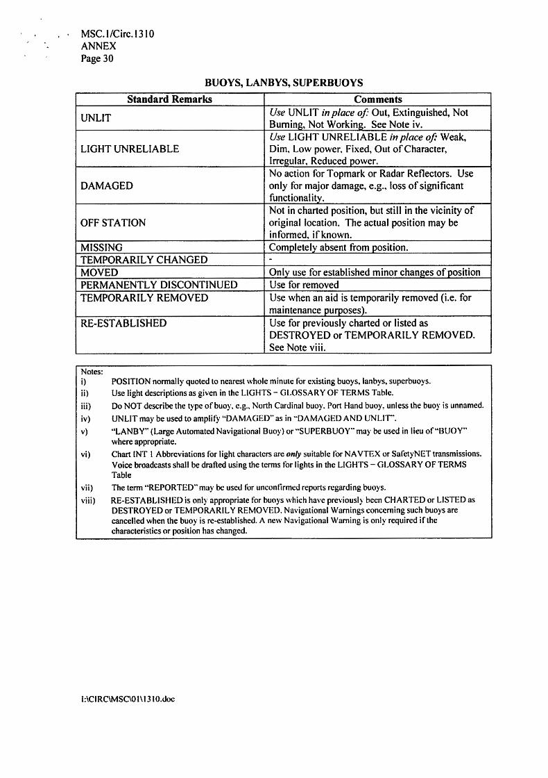
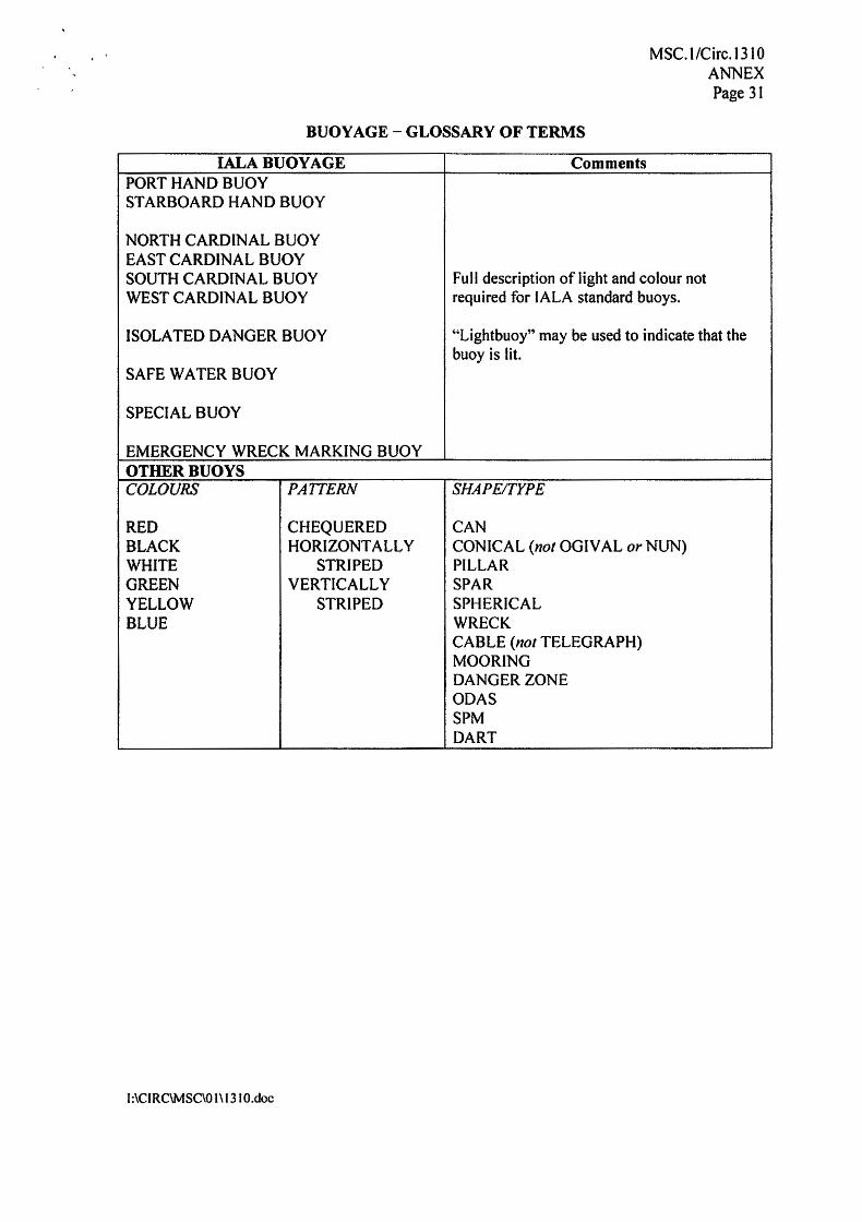
Notes: i) POSITION normally quoted to nearest whole minute for existing buoys, lanbys, superbuoys. ii) Use light descriptions as given in the LIGHTS - GLOSSARY OF TERMS Table. iii) Do NOT describe the type of buoy. e.g .. North Cardinal buoy. Port Hand buoy, unless the buoy is unnamed. iv) UNLIT may be used to amplify '"DAMAGED" as in ··DAMAGED AND UNLIT'. v) "LANBY'" (Large Automated Navigational Buoy) or .. SUPERBuoy·· may be used in lieu of••euoy·•
where appropriate. vi) Chart INT I Abbreviations for light characters arc only suitable for NA VTEX or SafetyNET transmissions.
Voice broadcasts shall be drafted using the terms for lights in the LIGHTS - GLOSSARY OF TERMS Table
vii) The term "REPORTED .. may be used for unconfirmed reports regarding buoys. viii) RE-ESTABLISHED is only appropriate for buoys which have previously been CHARTED or LISTED as
DESTROYED or TEMPORARILY REMOVED. Navigational Warnings concerning such buoys are cancelled when the buoy is re-established. A new Navigational Warning is only required if the characteristics or position has changed.
Standard Remarks Comments
UNLIT Use UNLIT in place of' Out, Extinguished, Not Buminj?;, Not Working. See Note iv. Use LIGHT UNRELIABLE in place of: Weak,
LIGHT UNRELIABLE Dim. Low power. Fixed, Out of Character, Irregular. Reduced power. No action for Topmark or Radar Reflectors. Use
DAMAGED only for major damage, e.g., loss of significant functional itv. Not in charted position, but still in the vicinity of
OFF STATION original location. The actual position may be informed, if known.
MISSING Completelv absent from position. TEMPORARILY CHANGED - MOVED Only use for established minor changes of position PERMANENTLY DISCONTINUED Use for removed TEMPORARILY REMOVED Use when an aid is temporarily removed (i.e. for
maintenance purposes). RE-ESTABLISHED Use for previously charted or listed as
DESTROYED or TEMPORARILY REMOVED. See Note viii.
BUOYS, LANBYS, SUPERBUOYS
MSC. l/Circ.1310 ANNEX Page 30
l:\CIRC\MSC\01\1310.doc
v)
iii)
Notes: i) ii)
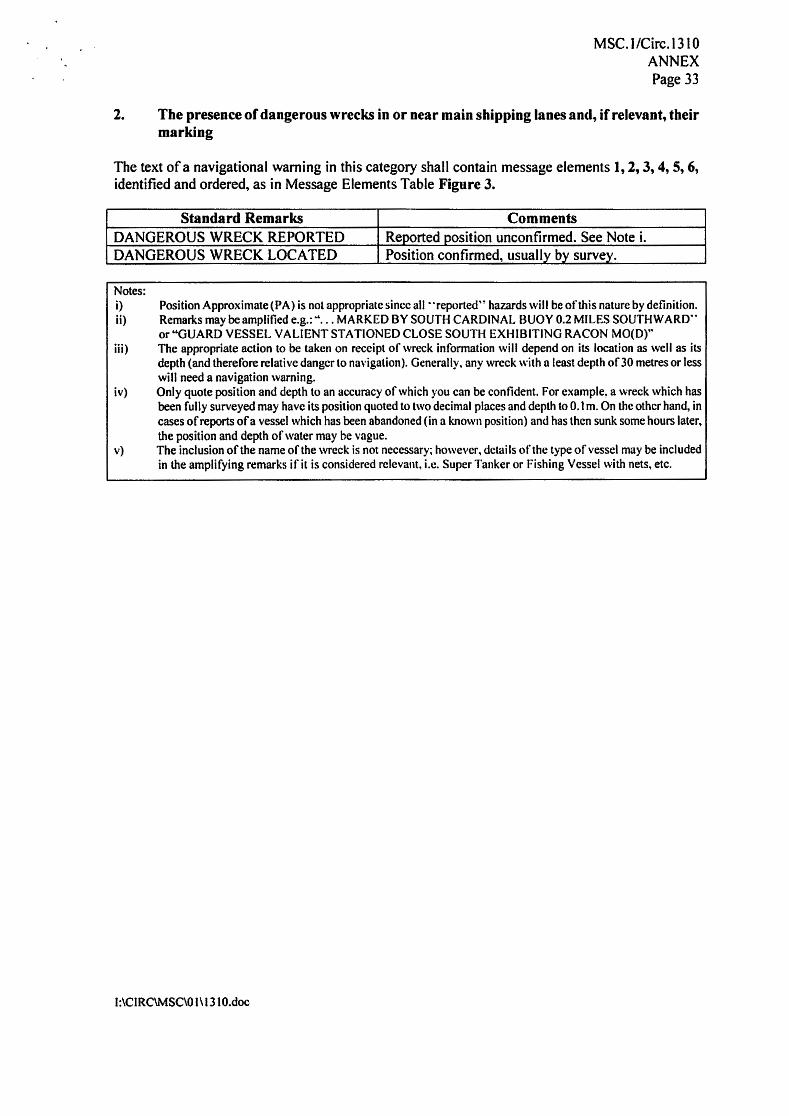
Position Approximate (PA) is not appropriate since all "repcrted" hazards will be ofthis nature by definition. Remarks may be amplified e.g.;" ... MARKED BY SOUTH CARDINAL BUOY 0.2 MILES SOUTHWARD .. or "GUARD VESSEL VA LI ENT STATIONED CLOSE SOUTH EXHIBITING RA CON MO(D)" The appropriate action to be taken on receipt of wreck information will depend on its location as well as its depth (and therefore relative danger to navigation). Generally, any wreck with a least depth of30 metres or less will need a navigation warning. Only quote position and depth to an accuracy of which you can be confident. For example, a wreck which has been fully surveyed may have its position quoted to two decimal places and depth to 0.1 m. On the other hand, in cases of reports ofa vessel which has been abandoned (in a known position) and has then sunk some hours later, the position and depth of water may be vague. The inclusion of the name of the wreck is not necessary; however, details of the type of vessel may be included in the amplifying remarks if it is considered relevant, i.e. Super Tanker or Fishing Vessel with nets, etc.
iv)
Standard Remarks Comments DANGEROUS WRECK REPORTED Reported position unconfirmed. See Note i. DANGEROUS WRECK LOCATED Position confirmed, usually by survey.
The text of a navigational warning in this category shall contain message elements 1, 2, 3, 4, 5, 6, identified and ordered, as in Message Elements Table Figure 3.
2. The presence of dangerous wrecks in or near main shipping lanes and, if relevant, their marking
MSC.1/Circ.1310 ANNEX Page 33
l:\CIRC\MSC\01\1310.doc
CAN CONICAL (not OGIVAL or NUN) PILLAR SPAR SPHERICAL WRECK CABLE (not TELEGRAPH) MOORING DANGER ZONE ODAS SPM DART
CHEQUERED HORIZONTALLY
STRIPED VERTICALLY
STRIPED
RED BLACK WHITE GREEN YELLOW BLUE
COLOURS PAITERN SHAPE/TYPE
"Lightbuoy" may be used to indicate that the buoy is lit.
Full description of light and colour not required for IALA standard buoys.
EMERGENCY WRECK MARKING BUOY OTHER BUOYS
SPECIAL BUOY
SAFE WATER BUOY
ISOLATED DANGER BUOY
NORTH CARDINAL BUOY EAST CARDINAL BUOY SOUTH CARDINAL BUOY WEST CARDINAL BUOY
PORT HAND BUOY STARBOARD HAND BUOY
Comments
BUOY AGE - GLOSSARY OF TERMS
IALA BUOY AGE
MSC. l/Circ.1310 ANNEX Page 31

l:\CIRaMSC\O I\ 1310.doc
Use CHARTED names. not LISTED names. LIGHT LIST number is not required. POSITION normally quoted to nearest whole minute for existing lights. For new lights or changed positions, quote accurate CHARTED position; in degrees, minutes and decimal minutes (maximum 2 decimal places). Always quote FULL LIGHT CHARACTERISTIC to avoid confusion over what has been changed. Damage to DA YMARKS is not usually worthy a navigational warning. Use light descriptions as given in the LIGHTS-GLOSSARY OF TERMS Table. Distances shall be quoted in nautical miles and decimals. RE-ESTABLISHED is only appropriate for aids which have previously been CHARTED or LISTED as DESTROYED or TEMPORARILY REMOVED. Navigational Warnings concerning such aids are cancelled when the aid is re-established. A new Navigational Warning is only required if the characteristics or position has changed. For new buoys, lanbys, superbuoys or changed positions. quote accurate CHARTED position; in degrees, minutes and decimal minutes (maximum 2 decimal places). Chart INT I Abbreviations for light characters are on(i· suitable for NA VTEX or SatetyNET transmissions. Voice broadcasts shall be drafted using the terms for lights in the LIGHTS - GLOSSARY OF TERMS Table.
xi)
x)
v) vi) vii) viii) ix)
Notes: i) ii) iii) iv)
Standard Remarks Comments ESTABLISHED The use of the word ESTABLISHED conveys that
the position and operation of the new or changed aid has been accurately confirmed by the appropriate competent authority.
RE-EST AB LI SHED For previously charted or listed as DESTROYED or TEMPORARILY REMOVED. See Note ix.
The text of a navigational warning in this category shall contain message elements 1, 2, 3, 4, 5, 6, identified and ordered, as in Message Elements Table Figure 3.
3. Establishment of major new aids to navigation or significant changes to existing ones when such establishment or change, might be misleading to shipping
MSC. I /Circ.1310 ANNEX Page 35
l:\CIRC\MSC\O 1\1310.doc
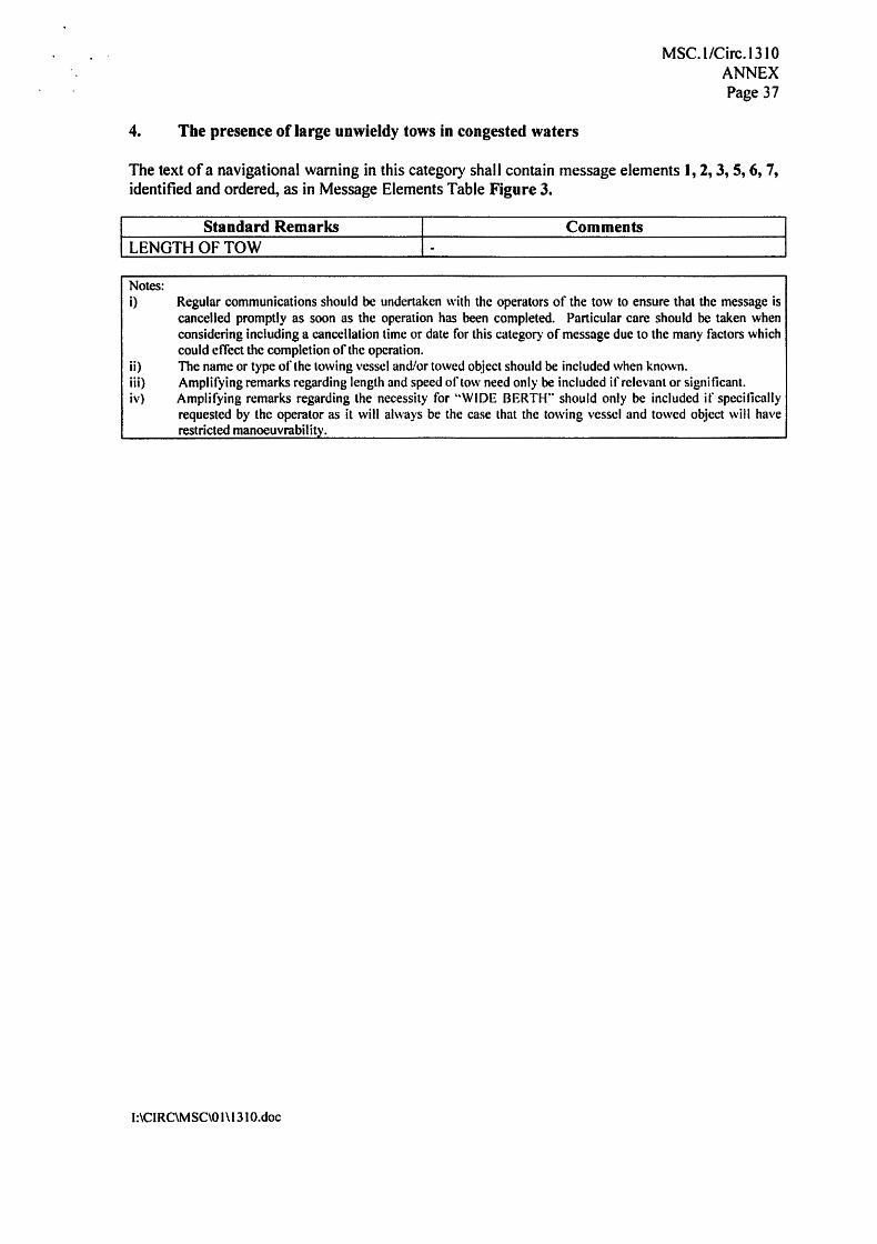
Notes: i) Regular communications should be undertaken with the operators of the tow to ensure that the message is
cancelled promptly as soon as the operation has been completed. Particular care should be taken when considering including a cancellation time or date for this category of message due to the many factors which could efTect the completion of the operation. The name or type of the towing vessel and/or towed object should be included when known. Amplifying remarks regarding length and speed of tow need only be included if relevant or significant. Amplifying remarks regarding the necessity for "WIDE BERTH .. should only be included if specifically requested by the operator as it will always be the case that the towing vessel and towed object will have restricted manoeuvrability.
ii) iii) iv)
Comments 1- LENGTH OF TOW
I Standard Remarks
The text of a navigational warning in this category shall contain message elements I, 2, 3, 5, 6, 7, identified and ordered, as in Message Elements Table Figure 3.
4. The presence of large unwieldy tows in congested waters
MSC. l/Circ.1310 ANNEX Page 37
l:\CIRC\MSC\O I\ 13 IO.doc
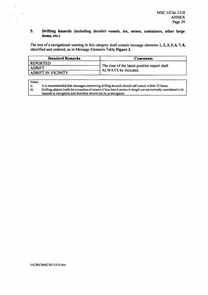
Notes: i) It is recommended that messages concerning drilling hazards should self cancel within 72 hours. ii) Drifting objects (with the exception of mines) of less than 6 metres in length are not normally considered to be
hazards to navigation and therefore should not be promulgated.
Standard Remarks Comments REPORTED The time of the latest position report shall ADRIFT ADRIFT IN VICINITY ALWAYS be included.
The text of a navigational warning in this category shall contain message elements 1, 2, 3, 5, 6, 7, 8, identified and ordered, as in Message Elements Table Figure 3.
S. Drifting hazards (including derelict vessels, ice, mines, containers, other large items, ete.)
MSC. I /Circ.13 10 ANNEX Page 39

l:\CIRC\MSC\O l \ 131 O.doc
Standard Remarks Comments SAR OPERATION - ANTIPOLLUTION OPERATIONS -
The text of a navigational warning in this category shall contain message elements 1, 2, 3, 5, 6, 7, identified and ordered, as in Message Elements Table Figure 3.
6. Areas where search and rescue (SAR) and anti-pollution operations are being carried out (for avoidance of such areas)
MSC.1/Circ.1310 ANNEX Page 41
l:\CIRC\MSC\01\1310.doc
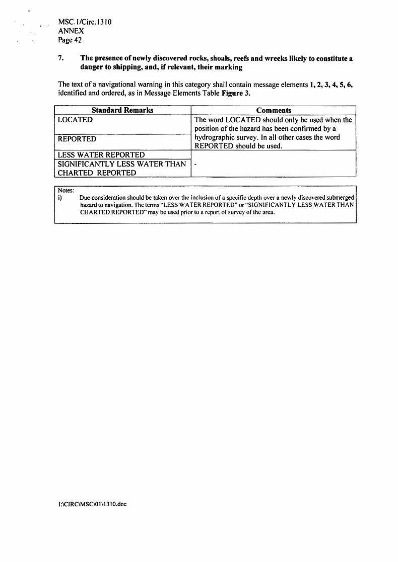
Notes: i) Due consideration should be taken over the inclusion of a specific depth over a newly discovered submerged
hazard to navigation. The terms ··LESS WATER REPORTED .. or "SIGNIFICANTLY LESS WATER THAN CHARTED REPORTED" may be used prior to a report of survey of the area.
Standard Remarks Comments LOCATED The word LOCATED should only be used when the
position of the hazard has been confirmed by a REPORTED hydrographic survey. In all other cases the word
REPORTED should be used. LESS WATER REPORTED SIGNIFICANTLY LESS WATER THAN - CHARTED REPORTED
The text of a navigational warning in this category shall contain message elements 1, 2, 3, 4, 5, 6, identified and ordered, as in Message Elements Table Figure 3.
7. The presence of newly discovered rocks, shoals, reefs and wrecks likely to constitute a danger to shipping, and, if relevant, their marking
MSC. l/Circ.1310 ANNEX Page 42

l:\CIRC\MSC\O I\ 131 O.doc
Notes: i) Regular communications should be undertaken with the operators to ensure that the message is cancelled
promptly as soon as the operation has been completed. Particular care should be taken when considering including a cancellation time or date for this category of message due to the many factors which could effect the completion of the operation.
ii) Use •'REQUESTED" when wide berth is for the benefit of the ship which is performing the operation. iii) Use "ADVISED .. when the operations create a significant hazard.
Standard Remarks Comments CABLE LA YING OPERATIONS IN PROGRESS - SEISMIC SURVEY IN PROGRESS - UNDERWATER OPERATIONS Do not use hSUBMARINE OPERATIONS" SCIENTIFIC OPERATIONS IN PROGRESS -
The text of a navigational warning in this category shall contain message elements 1, 2, 3, 5, 6, 7, identified and ordered, as in Message Elements Table Figure 3.
9. Cable or pipe-laying activities, the towing of large submerged objects for research or exploration purposes, the employment of manned or unmanned submersibles, or other underwater operations constituting potential dangers in or near shipping lanes
MSC. J /Circ.13 J 0 ANNEX Page 46
l:\CIRC\MSOOl\1310.doc
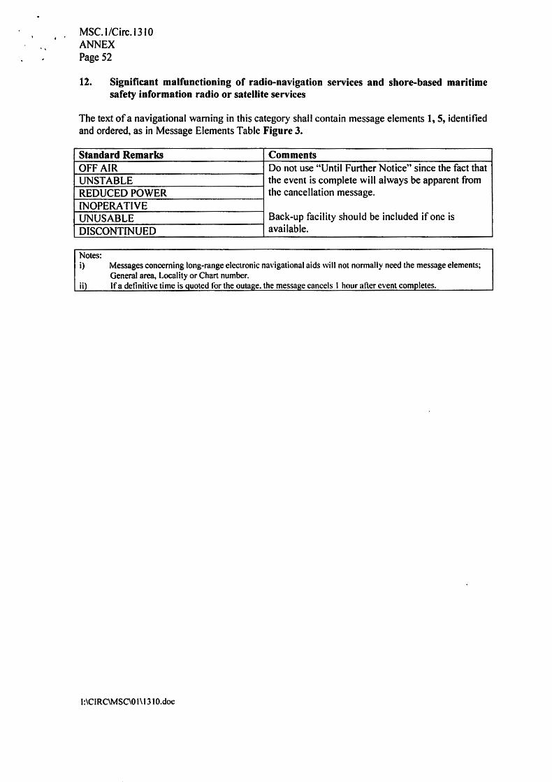
Notes: i) Messages concerning long-range electronic navigational aids will not normally need the message elements;
General area, Locality or Chart number. ii) If a definitive time is quoted for the outage. the message cancels I hour after event completes.
Standard Remarks Comments OFF AIR Do not use "Until Further Notice" since the fact that UNSTABLE the event is complete will always be apparent from REDUCED POWER the cancellation message. INOPERATIVE UNUSABLE Back-up facility should be included if one is DISCONTINUED available.
The text of a navigational warning in this category shall contain message elements 1, 5, identified and ordered, as in Message Elements Table Figure 3.
12. Significant malfunctioning of radio-navigation services and shore-based maritime safety information radio or satellite services
MSC. l/Circ.1310 ANNEX Page 52

l:\CIRC\MSC\01\1310.doc
Note: i) Add amplifying information if available for example. "Regional Piracy Centre, KUALA LUMPUR, TEL.
FAX. E-MAIL":
Standard Remarks Comments ACT OF PIRACY - ARMED ROBBERY -
The text of a navigational warning in this category shall contain message elements 1, 2, 3, 5, 6, identified and ordered, as in Message Elements Table Figure 3.
14. Acts of piracy and armed robbery against ships
MSC. I /Circ.1310 ANNEX Page 56
l:\CIRC\MSC\O 1\13 IO.doc
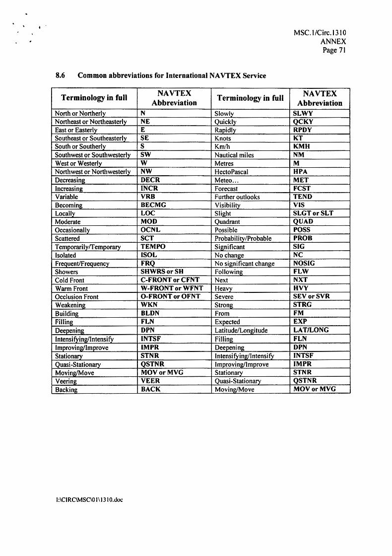
Terminology in full NAVTEX Terminology in full NAVTEX Abbreviation Abbreviation
North or Northerly N Slowly SLWY Northeast or Northeasterly NE Quickly QCKY East or Easterly E Rapidly RPDY Southeast or Southeasterly SE Knots KT South or Southerly s Km/h KMH Southwest or Southwesterly SW Nautical mi Jes NM West or Westerly w Metres M Northwest or Northwesterly NW HectoPascal HPA Decreasing DECR Meteo ... MET Increasing INCR Forecast FCST Variable VRB Further outlooks TEND Becoming BECMG Visibility VIS Locally LOC Slight SLGTorSLT Moderate MOD Quadrant QUAD Occasionally OCNL Possible POSS Scattered SCT Probabilitv/Probable PROB Temporarily/Temporary TEMPO Significant SIG Isolated ISOL No change NC Frequent/frequency FRQ No sianificant change NOSIG Showers SHWRSorSH Following FLW Cold Front C-FRONT or CFNT Next NXT Warm Front W-FRONT or WFNT Heavy HVY Occlusion Front 0-FRONT or OFNT Severe SEVorSVR Weakening WKN Strong STRG Building BLDN From FM Filling FLN Exoected EXP Deepening DPN Latitude/Longitude LAT/LONG I ntensi fying./l ntensi f y INTSF Filling FLN Improving/Improve IMPR Deenenina DPN Stationary STNR Intensifying/Intensify INTSF Quasi-Stationary QSTNR Improving/Improve IMPR Moving/Move MOVorMVG Stationary STNR Veering VEER Quasi-Stationary QSTNR Backing BACK Moving/Move MOVorMVG
8.6 Common abbreviations for International NA VTEX Service
MSC.1/Circ.1310 ANNEX Page 71