gp-3105 gravity & magnetic · 1. mahasiswa mampu menjelaskan teori dasar metode gayaberat serta...
TRANSCRIPT
Djedi S. Widarto
Dicky Ahmad Zaky
GP-3105 GRAVITY & MAGNETICMETODE GAYABERAT & MAGNETIK TA 2019/2020
Program Studi Teknik Geofisika
Fakultas Teknologi Eksplorasi dan Produksi
Universitas Pertamina
LECTURE #01
Penjelasan Perkuliahan dan RPS
Memberikan pengertian kepada mahasiswa tentang metoda gayaberat dan magnetik dalam geofisika eksplorasi, mulai dari prinsip dasar gayaberat dan magnetik, kemudian pengambilan, pengolahan, pemodelandan interpretasi data gayaberat dan magnetik untuk aplikasi studi geodinamika, eksplorasi sumberdaya (geothermal, air, minyak-gasbumi, mineral), geoteknik dan lingkungan.
TUJUAN
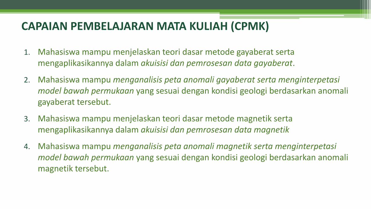
1. Mahasiswa mampu menjelaskan teori dasar metode gayaberat serta mengaplikasikannya dalam akuisisi dan pemrosesan data gayaberat.
2. Mahasiswa mampu menganalisis peta anomali gayaberat serta menginterpetasi model bawah permukaan yang sesuai dengan kondisi geologi berdasarkan anomali gayaberat tersebut.
3. Mahasiswa mampu menjelaskan teori dasar metode magnetik serta mengaplikasikannya dalam akuisisi dan pemrosesan data magnetik
4. Mahasiswa mampu menganalisis peta anomali magnetik serta menginterpetasi model bawah permukaan yang sesuai dengan kondisi geologi berdasarkan anomali magnetik tersebut.
CAPAIAN PEMBELAJARAN MATA KULIAH (CPMK)
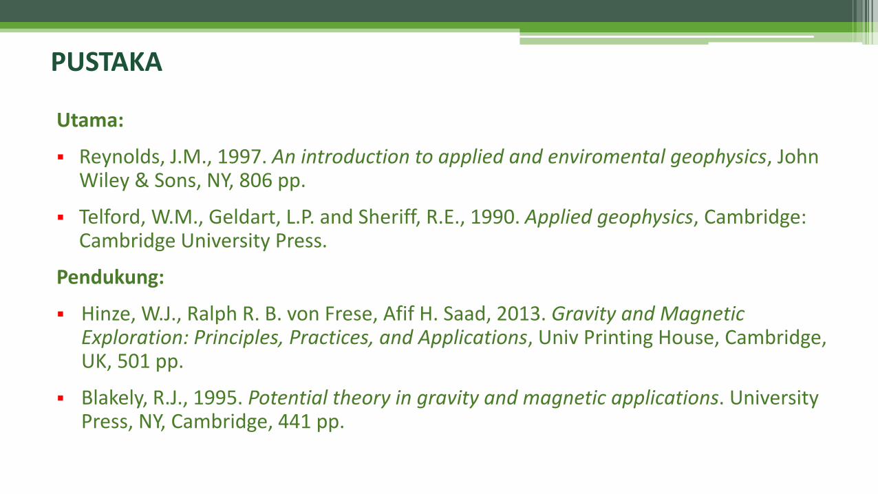
Utama:
▪ Reynolds, J.M., 1997. An introduction to applied and enviromental geophysics, John Wiley & Sons, NY, 806 pp.
▪ Telford, W.M., Geldart, L.P. and Sheriff, R.E., 1990. Applied geophysics, Cambridge: Cambridge University Press.
Pendukung:
▪ Hinze, W.J., Ralph R. B. von Frese, Afif H. Saad, 2013. Gravity and Magnetic Exploration: Principles, Practices, and Applications, Univ Printing House, Cambridge, UK, 501 pp.
▪ Blakely, R.J., 1995. Potential theory in gravity and magnetic applications. University Press, NY, Cambridge, 441 pp.
PUSTAKA

▪ UTS 30%
▪ UAS 30%
▪ PRAKTIKUM 25%
▪ TUGAS & QUIZ 15%
PENILAIAN
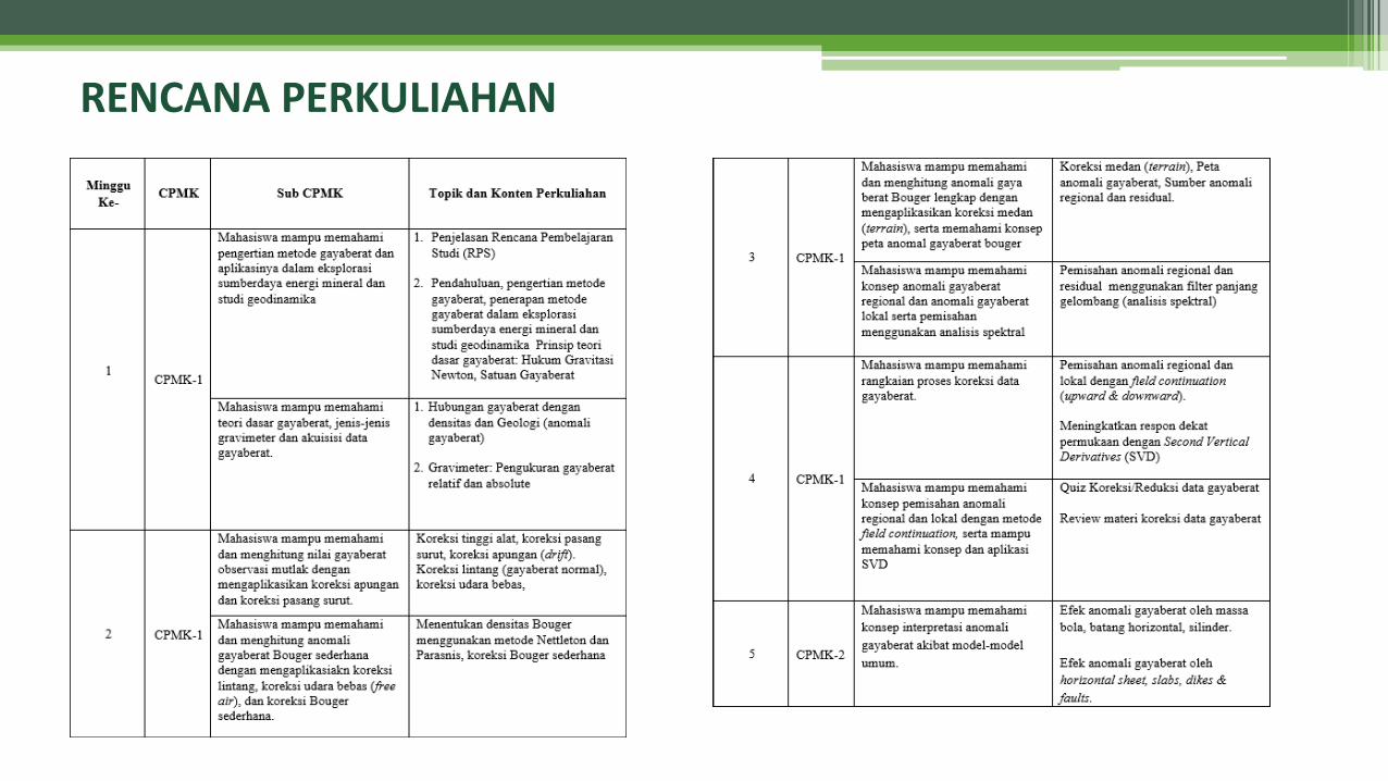
RENCANA PERKULIAHAN
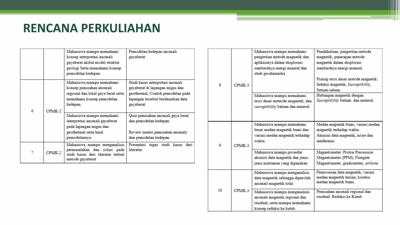
RENCANA PERKULIAHAN
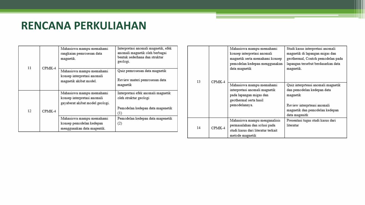
RENCANA PERKULIAHAN
GRAVITY METHOD▪ Introduction▪ Basic Theory of the Gravity Method▪ Gravitymeter: Instrumentation &
Acquisition
INTRODUCTION
What Are the Geophysical Methods?
▪ GEOPHYSICS:The study of the earth by quantitative physical methods, especially by seismic reflection and refraction, gravity, magnetic, electrical, electromagnetic, and radioactivity methods (Sheriff, 1999).
▪ EXPLORATION GEOPHYSICS / GEOPHYSICAL PROSPECTING / APPLIED GEOPHYSICS:Making and interpreting measurements of physical properties of the earth to determine subsurface conditions, usually with an economic objective, e.g., discovery of fuel or mineral deposits. Properties measured include seismic, gravity, magnetic, electric, and temperature (Sheriff, 1999).
▪ PETROLEUM GEOPHYSICS:Making and interpreting measurements of physical properties of the earth to determine subsurface conditions related to hydrocarbon.
Types of Geophysical Methods
Surface MethodsSeismic Methods :
▪ Seismic reflection methods▪ Surface wave (refraction) methods
Potential Field Methods :▪ Gravity & magnetic
Electrical Methods▪ Resistivity methods▪ Self-potential▪ Mise a-la masse methods▪ Induced polarization
Electromagnetic Methods▪ Magnetotelluric methods ▪ Time-domain electromagnetic methods▪ Ground penetrating radar▪ Very-low frequency methods▪ Seismo-electric method
Nuclear Methods▪ Nuclear magnetic resonance (NMR)
method
Borehole MethodsIn-Hole Procedures
Cross-Hole Procedures
Surface to Borehole Procedures:▪ Velocity surveys
▪ Vertical seismic profiling
Logging Techniques:▪ Electrical methods ▪ Acoustic logging▪ Nuclear logging
▪ Flow logging▪ Other methods of logging
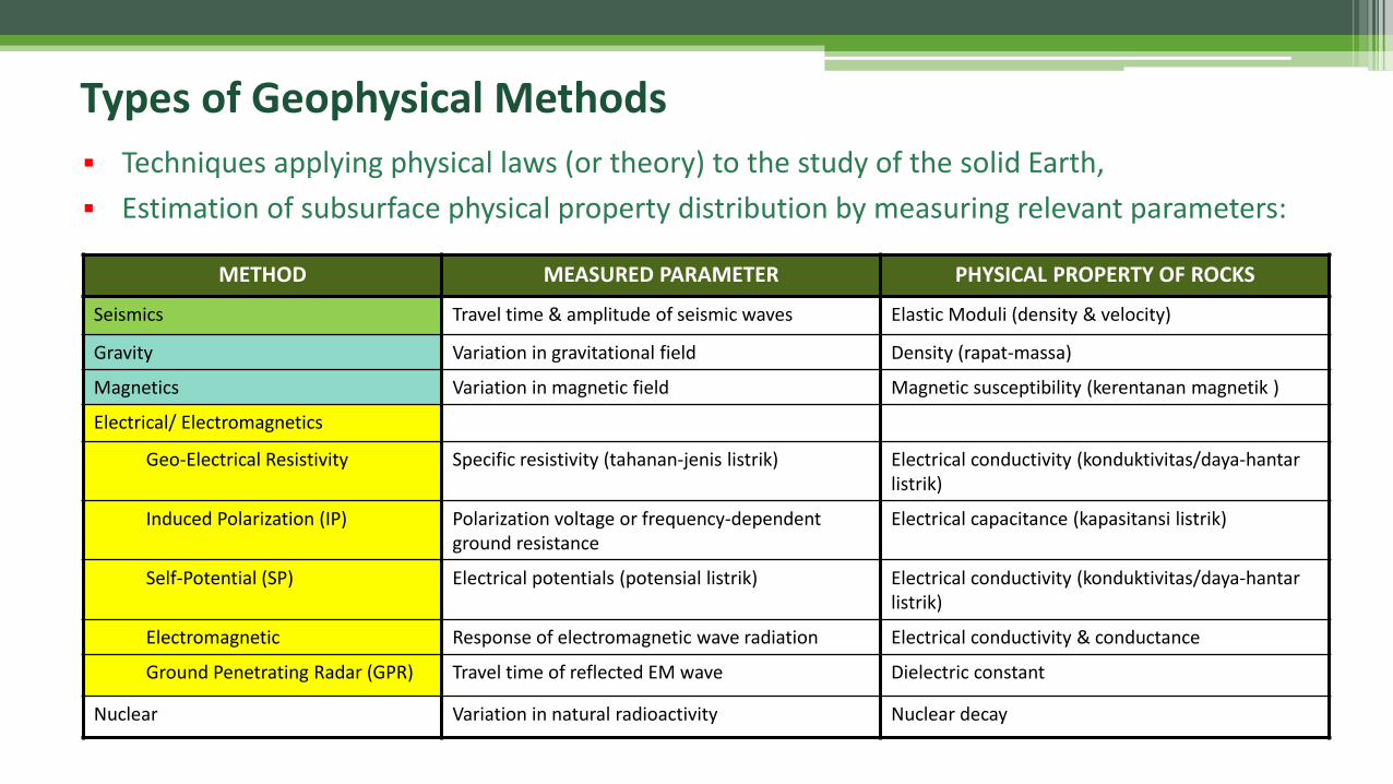
METHOD MEASURED PARAMETER PHYSICAL PROPERTY OF ROCKS
Seismics Travel time & amplitude of seismic waves Elastic Moduli (density & velocity)
Gravity Variation in gravitational field Density (rapat-massa)
Magnetics Variation in magnetic field Magnetic susceptibility (kerentanan magnetik )
Electrical/ Electromagnetics
Geo-Electrical Resistivity Specific resistivity (tahanan-jenis listrik) Electrical conductivity (konduktivitas/daya-hantar listrik)
Induced Polarization (IP) Polarization voltage or frequency-dependent ground resistance
Electrical capacitance (kapasitansi listrik)
Self-Potential (SP) Electrical potentials (potensial listrik) Electrical conductivity (konduktivitas/daya-hantar listrik)
Electromagnetic Response of electromagnetic wave radiation Electrical conductivity & conductance
Ground Penetrating Radar (GPR) Travel time of reflected EM wave Dielectric constant
Nuclear Variation in natural radioactivity Nuclear decay
Types of Geophysical Methods
▪ Techniques applying physical laws (or theory) to the study of the solid Earth,
▪ Estimation of subsurface physical property distribution by measuring relevant parameters:
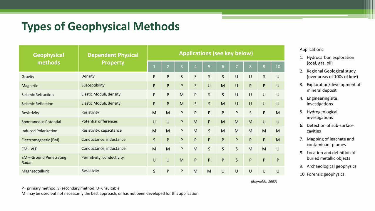
Geophysical methods
Dependent Physical Property
Applications (see key below)
1 2 3 4 5 6 7 8 9 10
Gravity Density P P S S S S U U S U
Magnetic Susceptibility P P P S U M U P P U
Seismic Refraction Elastic Moduli, density P P M P S S U U U U
Seismic Reflection Elastic Moduli, density P P M S S M U U U U
Resistivity Resistivity M M P P P P P S P M
Spontaneous Potential Potential differences U U P M P M M M U U
Induced Polarization Resistivity, capacitance M M P M S M M M M M
Electromagnetic (EM) Conductance, inductance S P P P P P P P P M
EM - VLF Conductance, inductance M M P M S S S M M U
EM – Ground Penetrating Radar
Permitivity, conductivityU U M P P P S P P P
Magnetotelluric Resistivity S P P M M U U U U U
P= primary method; S=secondary method; U=unsuitableM=may be used but not necessarily the best approach, or has not been developed for this application
Applications:
1. Hydrocarbon exploration (coal, gas, oil)
2. Regional Geological study (over areas of 100s of km2)
3. Exploration/development of mineral deposit
4. Engineering site investigations
5. Hydrogeological investigations
6. Detection of sub-surface cavities
7. Mapping of leachate and contaminant plumes
8. Location and definition of buried metallic objects
9. Archaeological geophysics
10. Forensic geophysics
(Reynolds, 1997)
Types of Geophysical Methods
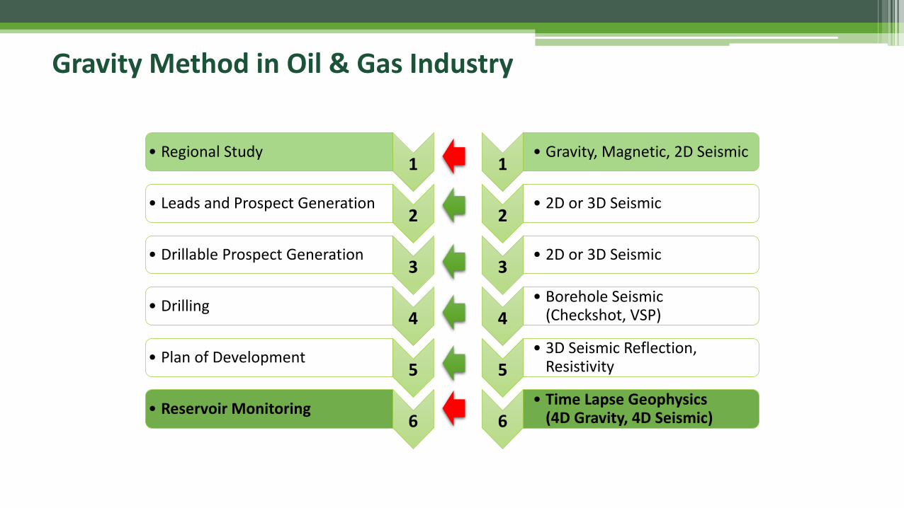
Gravity Method in Oil & Gas Industry
1• Regional Study
2• Leads and Prospect Generation
3• Drillable Prospect Generation
4• Drilling
5• Plan of Development
6• Reservoir Monitoring
1• Gravity, Magnetic, 2D Seismic
2• 2D or 3D Seismic
3• 2D or 3D Seismic
4• Borehole Seismic
(Checkshot, VSP)
5• 3D Seismic Reflection,
Resistivity
6• Time Lapse Geophysics
(4D Gravity, 4D Seismic)
(Bassett and Watts, 2015)
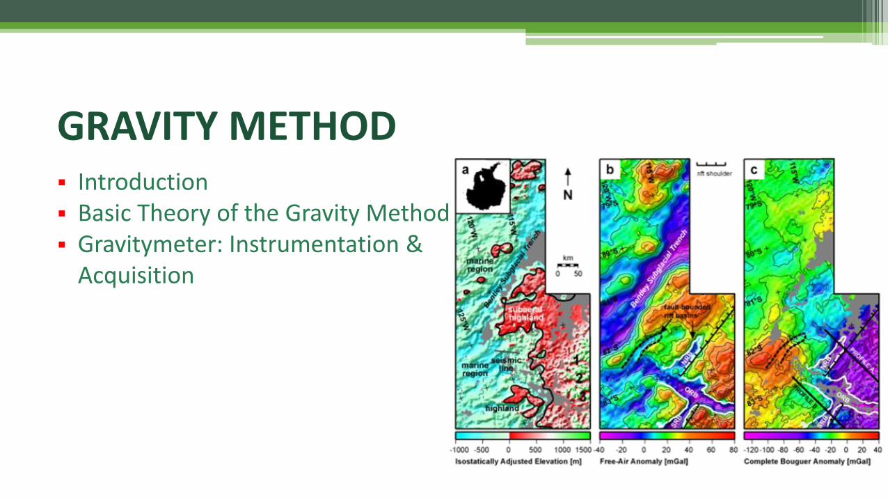
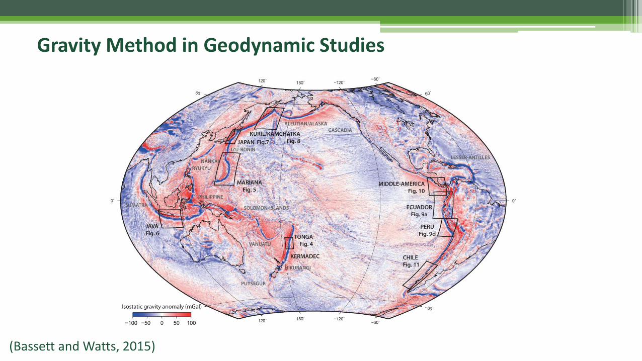
Gravity Method in Geodynamic Studies
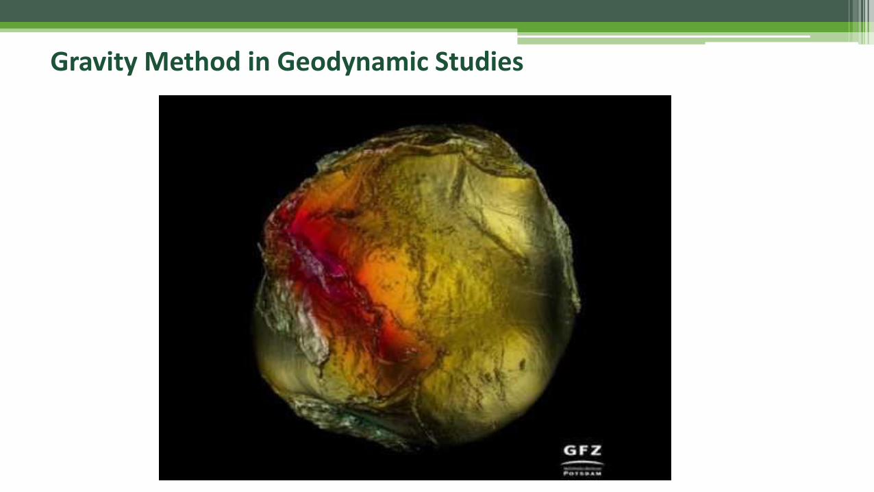
Gravity Method in Geodynamic Studies
What Are the Gravity Method?
▪ The method senses the Earth’s lateral density variation. Gravity measurements are affected by changes in rock density,
▪ The method, surface and subsurface surveys, are effective in locating faults and geologic structure with density contrasts to their surrounding,
▪ The borehole gravity meter has broad application, from locating porosity in wildcats or through casing in old wells to monitoring fluid changes in production reservoirs,
▪ Fast and inexpensive tool.

▪ 1590 : Galileo Galilei → free-fall experiments
▪ 1687 : Isaac Newton → Newton Law, establishment of theoretical foundation….
▪ 18th & 19th centuries:
✓ Development of pendulum-based gravimeter,
✓ First global application in geophysical exploration ….
▪ 1928 :
✓ Vening Meinez→ shipborne/marine gravity survey;
✓ First oil discovery at Nast Dome, Texas, using Eotvos torsion balancegravimeter ....
History of the Gravity Method
▪ 1932 : Pendulum gravimeter at Cleveland oil field, Texas;
▪ 1932-1935 : Manufacturing of gravimeter with 0.1 mGal accuracy;
▪ 1940 : gravimeter improvements by Worden and LaCoste & Romberg;
▪ 2000 - present:
✓ micro-gravitymeter (micro-Gal) by Scintrex,
✓ absolute gravimetry,
✓ gradient gravimetry,
✓ full-tensor gravimetry (FTG),
✓ satellite gravimetry ….
History of the Gravity Method
Application of the Gravity Method
▪ Geodynamic Studies (Land, Marine, Airborne & Satellite Gravimetry):
✓ Structural-tectonic & Regional Geology,
✓ Volcanology ....
▪ Energy, Mineral & Groundwater Exploration (Land, Marine & Airborne Gravimetry):
✓ Hydrocarbon basin study,
✓ Geothermal,
✓ Ore/mineral deposits,
✓ Groundwater resources ....
▪ Detailed Study (Land Gravimetry) :
✓ Reservoir monitoring (oil & gas, geothermal) → 4D (time-lapse) micro-gravimetry,
✓ Groundwater dynamic → 4D (time-lapse) micro-gravimetry ....
Basic Theory of the Gravity Method
Basic Theory of the Gravity Method
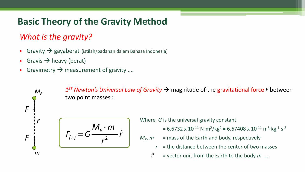
▪ Gravity → gayaberat (istilah/padanan dalam Bahasa Indonesia)
▪ Gravis → heavy (berat)
▪ Gravimetry →measurement of gravity ….
1ST Newton’s Universal Law of Gravity →magnitude of the gravitational force F between two point masses :
What is the gravity?
r
F
F
ME
m
Where G is the universal gravity constant
= 6.6732 x 10⁻¹¹ N-m2/kg2 = 6.67408 x 10⁻¹¹ m3·kg-1·s-2
ME, m = mass of the Earth and body, respectively
r = the distance between the center of two masses
= vector unit from the Earth to the body m ….r̂
r̂r
mMGF
E
)r( 2
=
Basic Theory of the Gravity Method
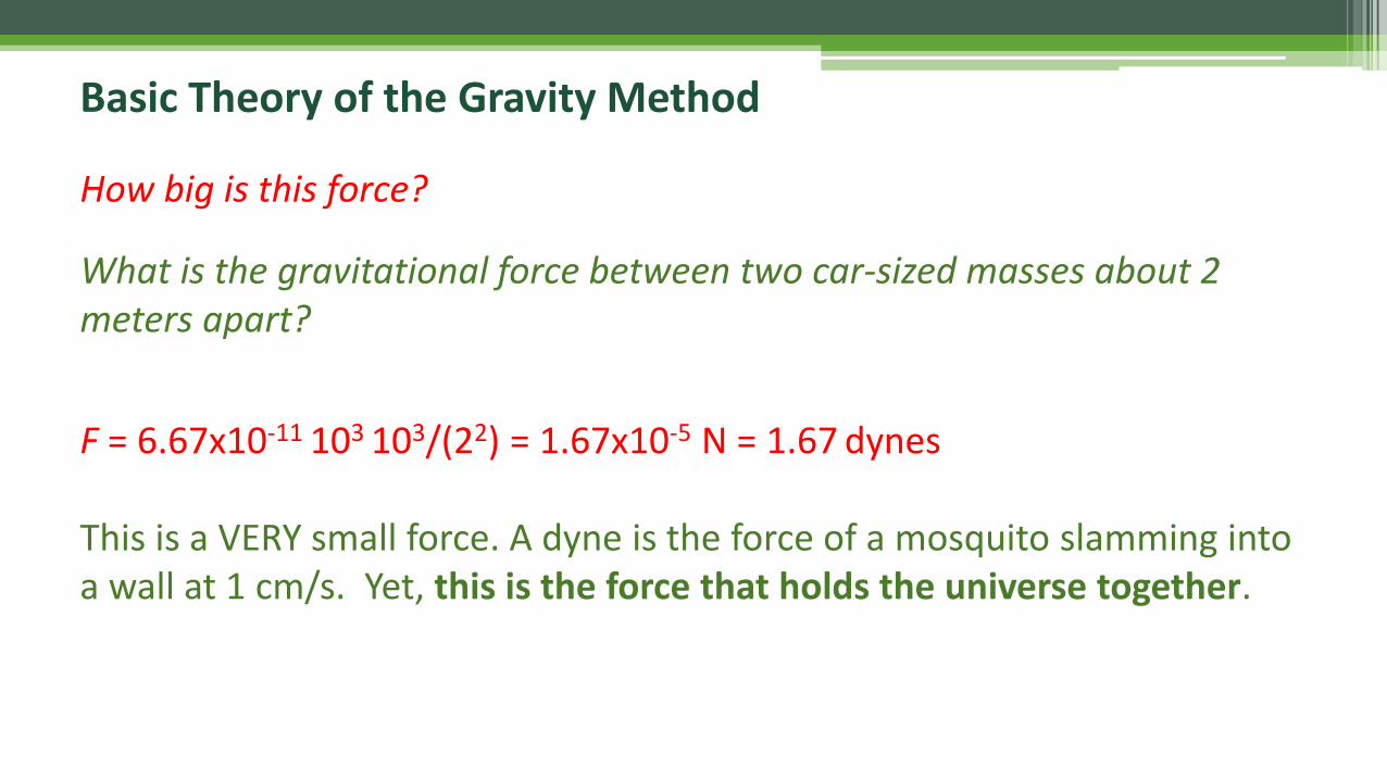
How big is this force?
What is the gravitational force between two car-sized masses about 2 meters apart?
F = 6.67x10⁻¹¹ 103 103/(22) = 1.67x10⁻⁵ N = 1.67 dynes
This is a VERY small force. A dyne is the force of a mosquito slamming into a wall at 1 cm/s. Yet, this is the force that holds the universe together.
Basic Theory of the Gravity Method
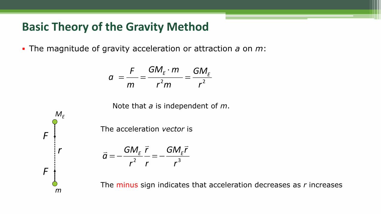
▪ The magnitude of gravity acceleration or attraction a on m:
22 r
GM
mr
mGM
m
Fa EE
=
==
Note that a is independent of m.
The acceleration vector is
32 r
rGM
r
r
r
GMa EE
−=−=
The minus sign indicates that acceleration decreases as r increases
r
F
F
ME
m
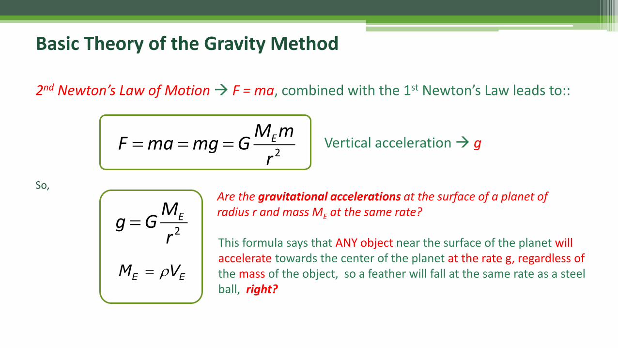
2nd Newton’s Law of Motion → F = ma, combined with the 1st Newton’s Law leads to::
Vertical acceleration → g
So,Are the gravitational accelerations at the surface of a planet of radius r and mass ME at the same rate?
Basic Theory of the Gravity Method
2r
mMGmgmaF E===
This formula says that ANY object near the surface of the planet will accelerate towards the center of the planet at the rate g, regardless ofthe mass of the object, so a feather will fall at the same rate as a steel ball, right?
2r
MGg E=
EE VM =
Basic Theory of the Gravity Method
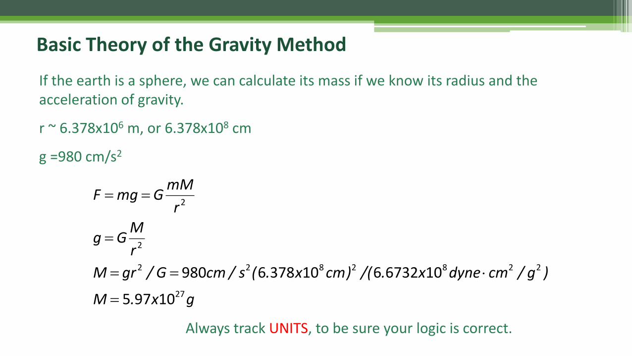
If the earth is a sphere, we can calculate its mass if we know its radius and the acceleration of gravity.
r ~ 6.378x10⁶ m, or 6.378x108 cm
g =980 cm/s2
gx.M
)g/cmdynex./()cmx.(s/cmG/grM
r
MGg
r
mMGmgF
27
2282822
2
2
10975
1067326103786980
=
==
=
==
Always track UNITS, to be sure your logic is correct.
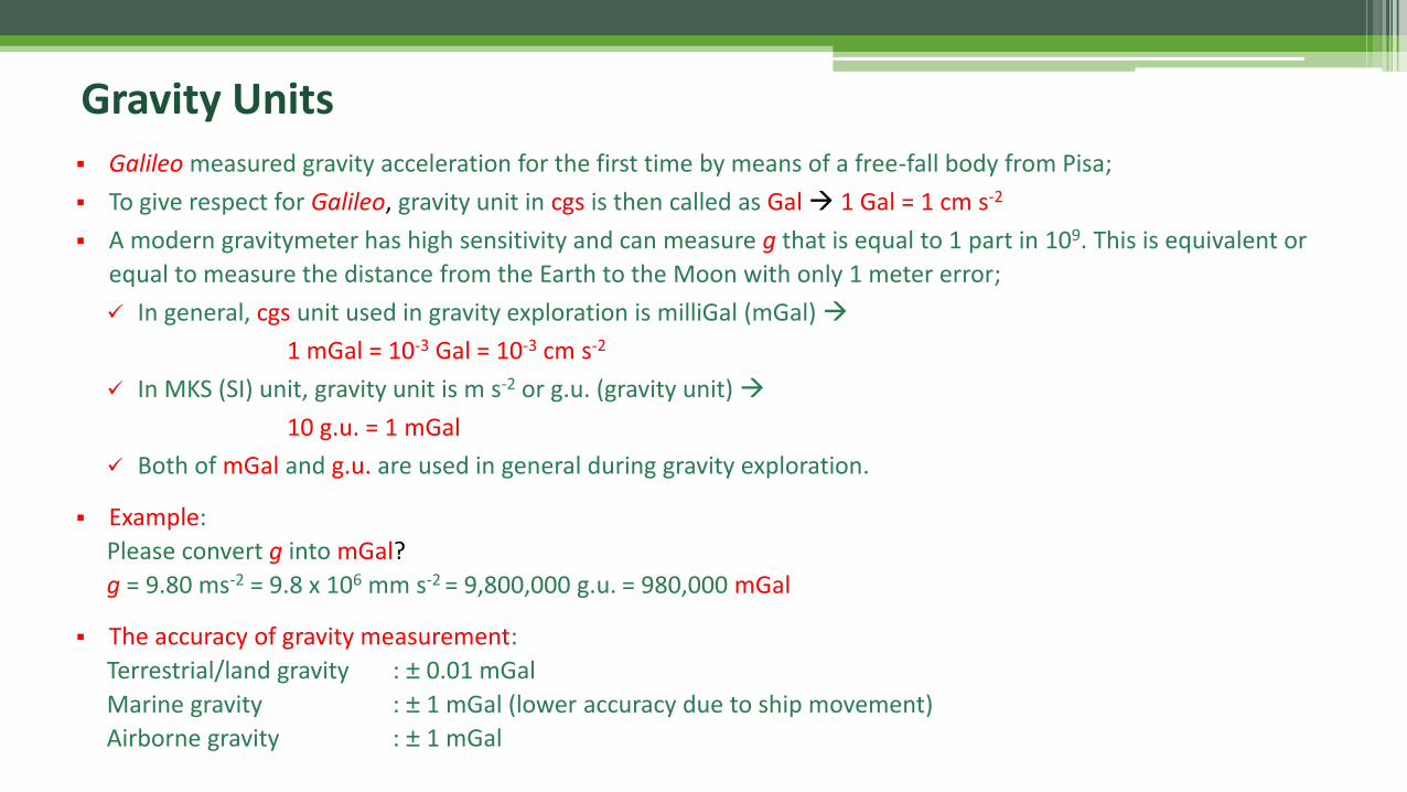
Gravity Units▪ Galileo measured gravity acceleration for the first time by means of a free-fall body from Pisa;
▪ To give respect for Galileo, gravity unit in cgs is then called as Gal→ 1 Gal = 1 cm s-2
▪ A modern gravitymeter has high sensitivity and can measure g that is equal to 1 part in 109. This is equivalent or
equal to measure the distance from the Earth to the Moon with only 1 meter error;
✓ In general, cgs unit used in gravity exploration is milliGal (mGal) →
1 mGal = 10-3 Gal = 10-3 cm s-2
✓ In MKS (SI) unit, gravity unit is m s-2 or g.u. (gravity unit) →
10 g.u. = 1 mGal
✓ Both of mGal and g.u. are used in general during gravity exploration.
▪ Example:
Please convert g into mGal?
g = 9.80 ms-2 = 9.8 x 106 mm s-2 = 9,800,000 g.u. = 980,000 mGal
▪ The accuracy of gravity measurement:
Terrestrial/land gravity : ± 0.01 mGal
Marine gravity : ± 1 mGal (lower accuracy due to ship movement)
Airborne gravity : ± 1 mGal
Gravity Variation on the Earth
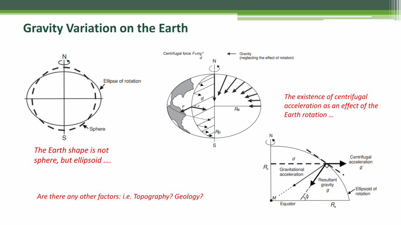
The Earth shape is not sphere, but ellipsoid ….
The existence of centrifugal acceleration as an effect of the Earth rotation …
Are there any other factors: i.e. Topography? Geology?
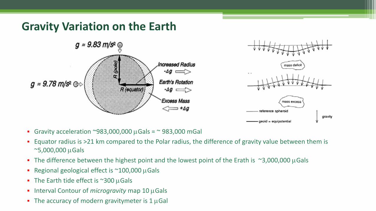
▪ Gravity acceleration ~983,000,000 mGals = ~ 983,000 mGal
▪ Equator radius is >21 km compared to the Polar radius, the difference of gravity value between them is~5,000,000 mGals
▪ The difference between the highest point and the lowest point of the Erath is ~3,000,000 mGals
▪ Regional geological effect is ~100,000 mGals
▪ The Earth tide effect is ~300 mGals
▪ Interval Contour of microgravity map 10 mGals
▪ The accuracy of modern gravitymeter is 1 mGal
Gravity Variation on the Earth
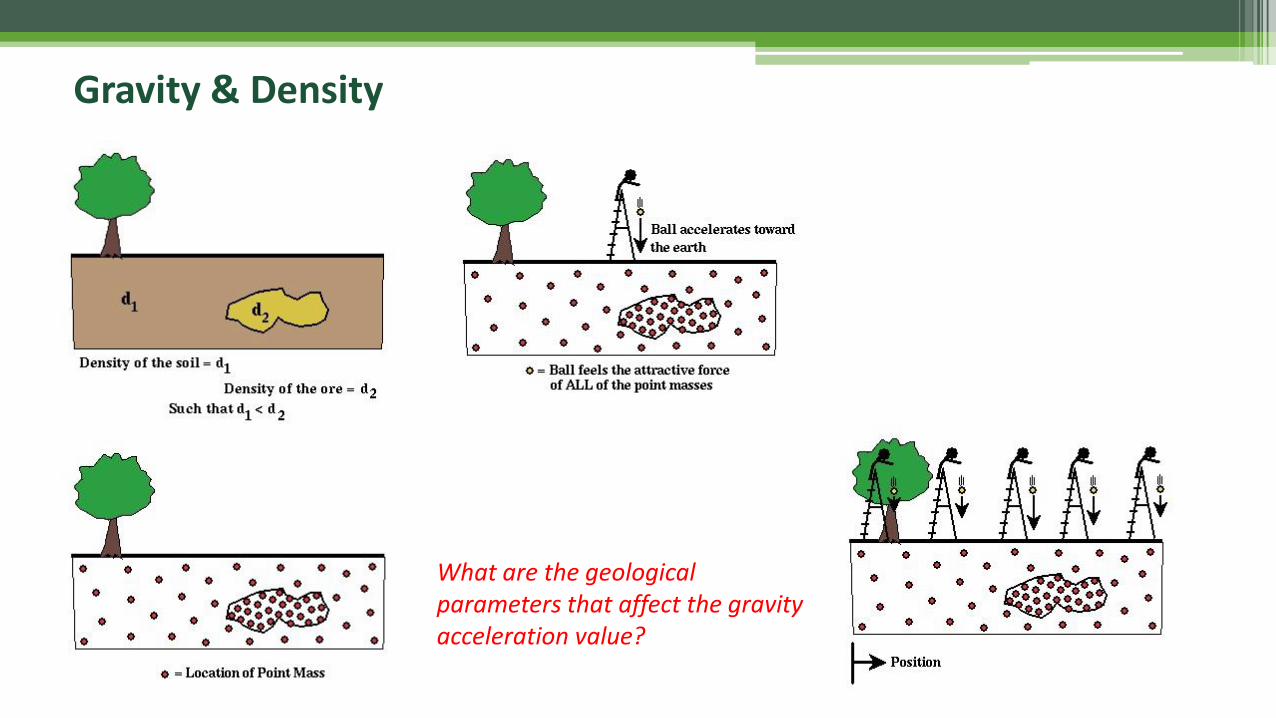
Gravity & Density
What are the geological parameters that affect the gravity acceleration value?
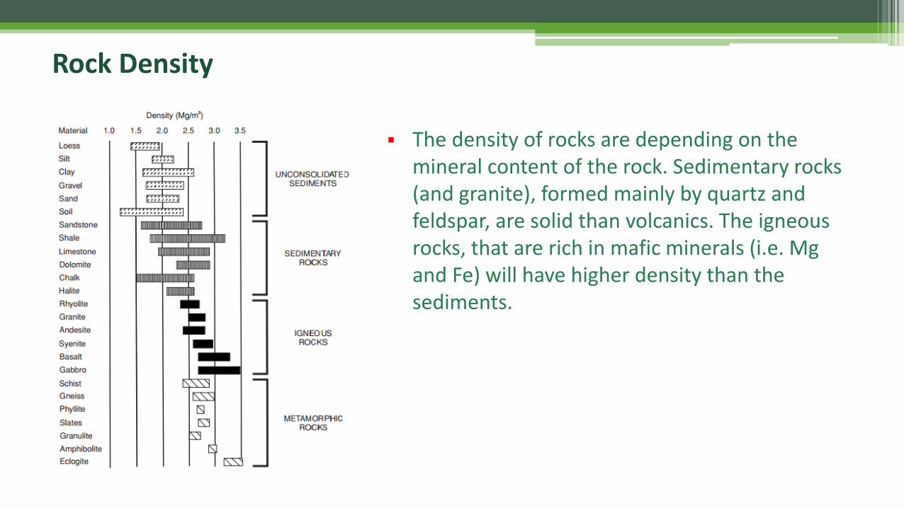
Rock Density
▪ The density of rocks are depending on the mineral content of the rock. Sedimentary rocks (and granite), formed mainly by quartz and feldspar, are solid than volcanics. The igneous rocks, that are rich in mafic minerals (i.e. Mg and Fe) will have higher density than the sediments.
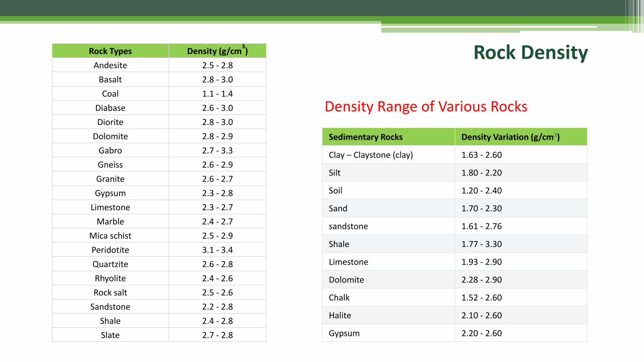
Rock Types Density (g/cm3)
Andesite 2.5 - 2.8
Basalt 2.8 - 3.0
Coal 1.1 - 1.4
Diabase 2.6 - 3.0
Diorite 2.8 - 3.0
Dolomite 2.8 - 2.9
Gabro 2.7 - 3.3
Gneiss 2.6 - 2.9
Granite 2.6 - 2.7
Gypsum 2.3 - 2.8
Limestone 2.3 - 2.7
Marble 2.4 - 2.7
Mica schist 2.5 - 2.9
Peridotite 3.1 - 3.4
Quartzite 2.6 - 2.8
Rhyolite 2.4 - 2.6
Rock salt 2.5 - 2.6
Sandstone 2.2 - 2.8
Shale 2.4 - 2.8
Slate 2.7 - 2.8
Sedimentary Rocks Density Variation (g/cm3)
Clay – Claystone (clay) 1.63 - 2.60
Silt 1.80 - 2.20
Soil 1.20 - 2.40
Sand 1.70 - 2.30
sandstone 1.61 - 2.76
Shale 1.77 - 3.30
Limestone 1.93 - 2.90
Dolomite 2.28 - 2.90
Chalk 1.52 - 2.60
Halite 2.10 - 2.60
Gypsum 2.20 - 2.60
Density Range of Various Rocks
Rock Density
Gravitymeter(Instrumentation & Acquisition)
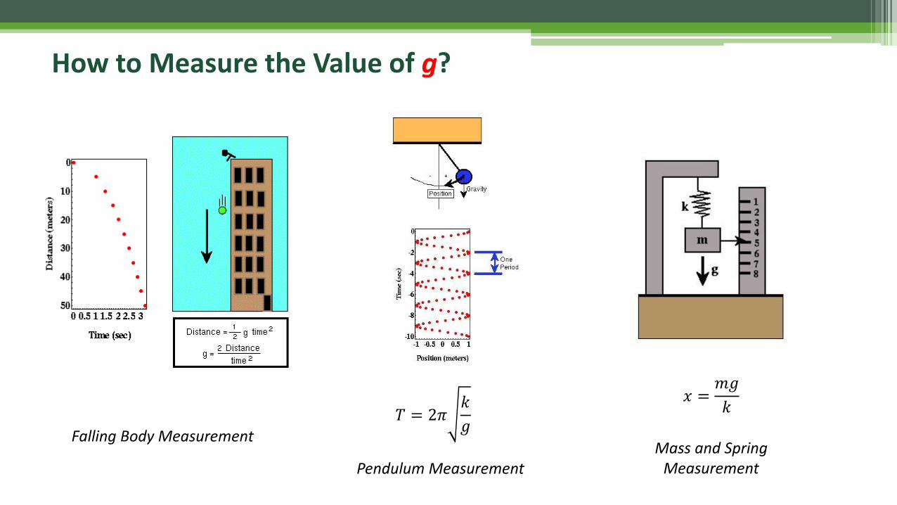
How to Measure the Value of g?
Falling Body Measurement
Pendulum MeasurementMass and Spring
Measurement
𝑇 = 2𝜋𝑘
𝑔
𝑥 =𝑚𝑔
𝑘
How to Measure the Value of g?
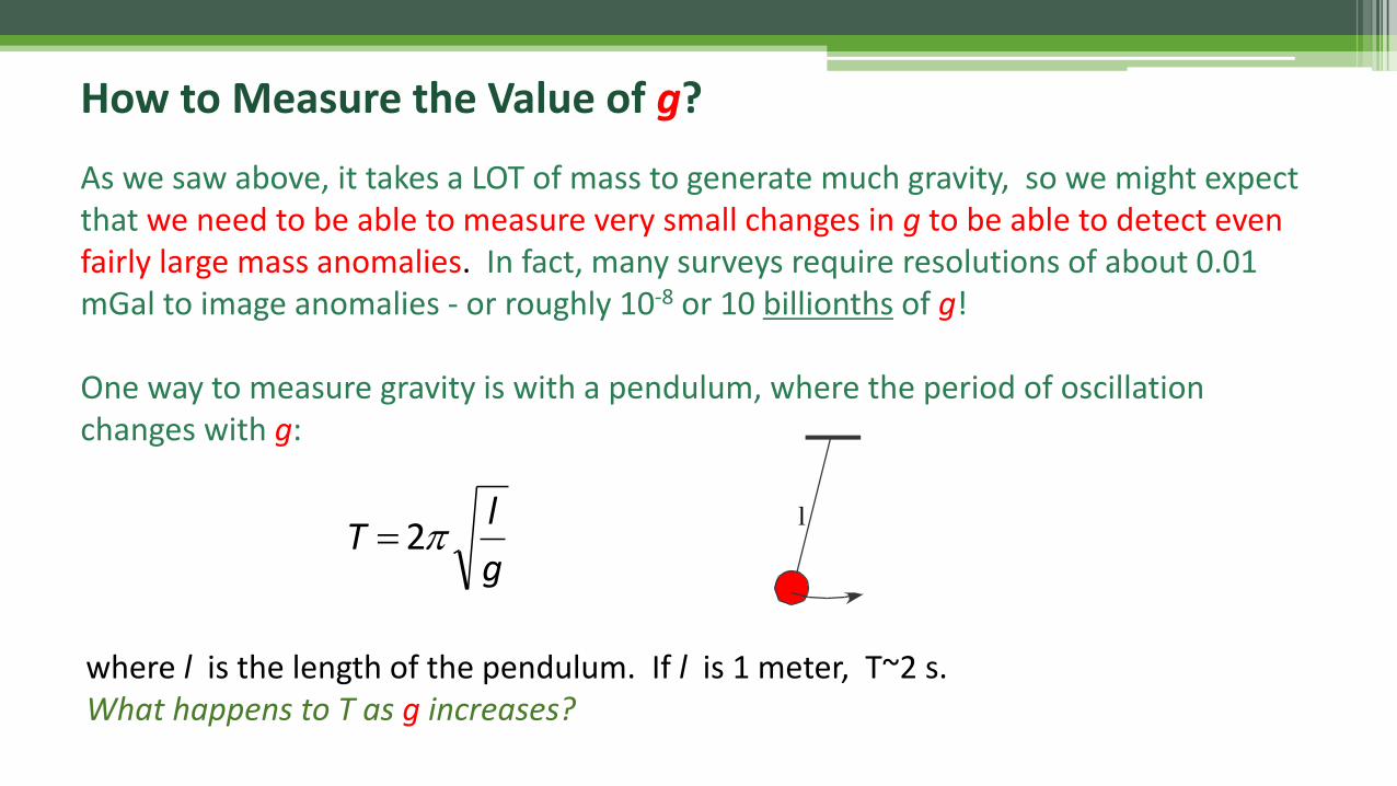
As we saw above, it takes a LOT of mass to generate much gravity, so we might expect that we need to be able to measure very small changes in g to be able to detect even fairly large mass anomalies. In fact, many surveys require resolutions of about 0.01 mGal to image anomalies - or roughly 10-8 or 10 billionths of g!
One way to measure gravity is with a pendulum, where the period of oscillation changes with g:
where l is the length of the pendulum. If l is 1 meter, T~2 s.What happens to T as g increases?
g
lT 2=
l
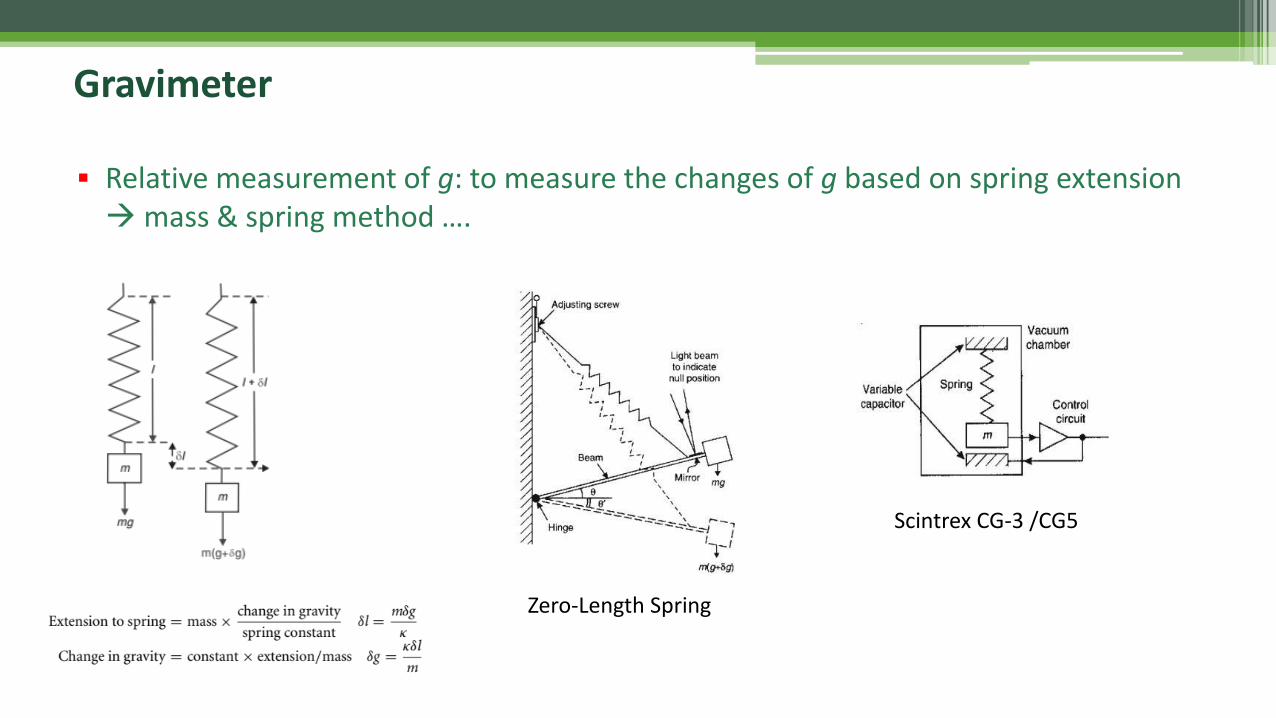
▪ Relative measurement of g: to measure the changes of g based on spring extension →mass & spring method ….
Scintrex CG-3 /CG5
Zero-Length Spring
Gravimeter

Land (Relative) Gravimeters: LaCoste & Romberg G / D Models
LaCoste-Romberg Gravimeter
Gravimeter
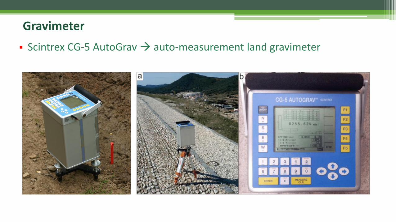
▪ Scintrex CG-5 AutoGrav → auto-measurement land gravimeter
Gravimeter
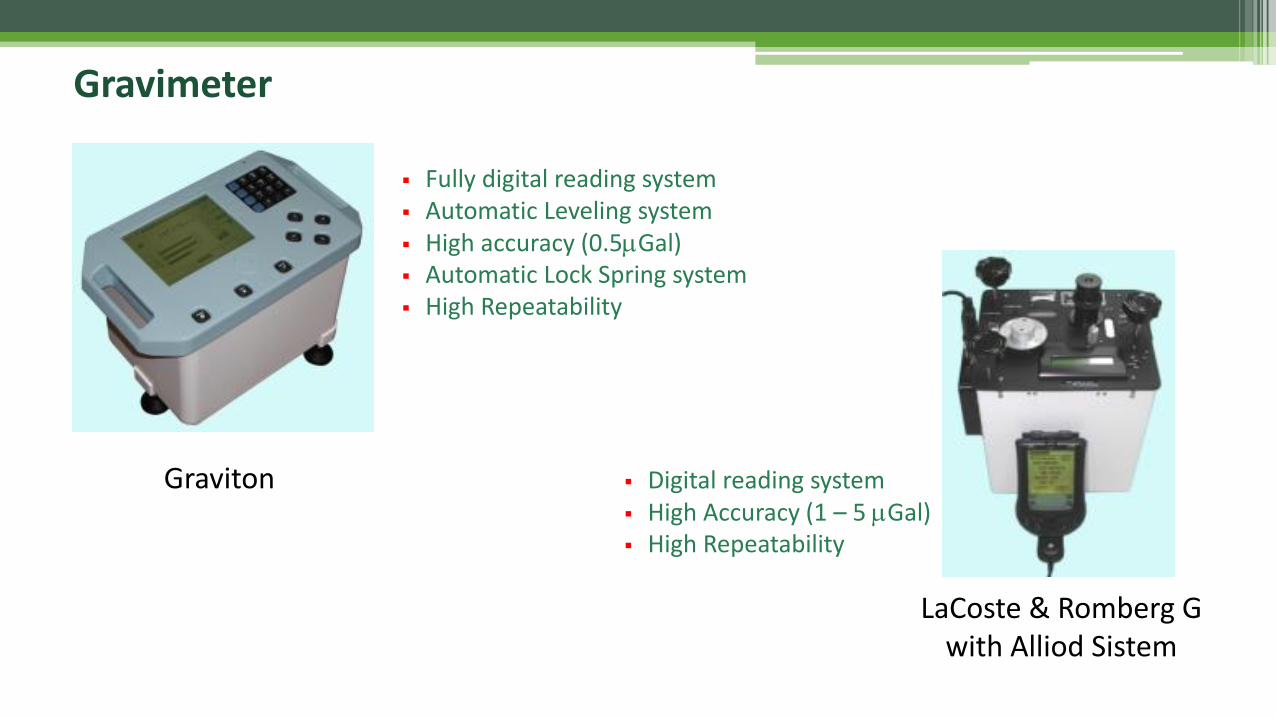
Graviton
LaCoste & Romberg G with Alliod Sistem
▪ Fully digital reading system▪ Automatic Leveling system ▪ High accuracy (0.5mGal)▪ Automatic Lock Spring system▪ High Repeatability
▪ Digital reading system ▪ High Accuracy (1 – 5 mGal)▪ High Repeatability
41
Gravimeter
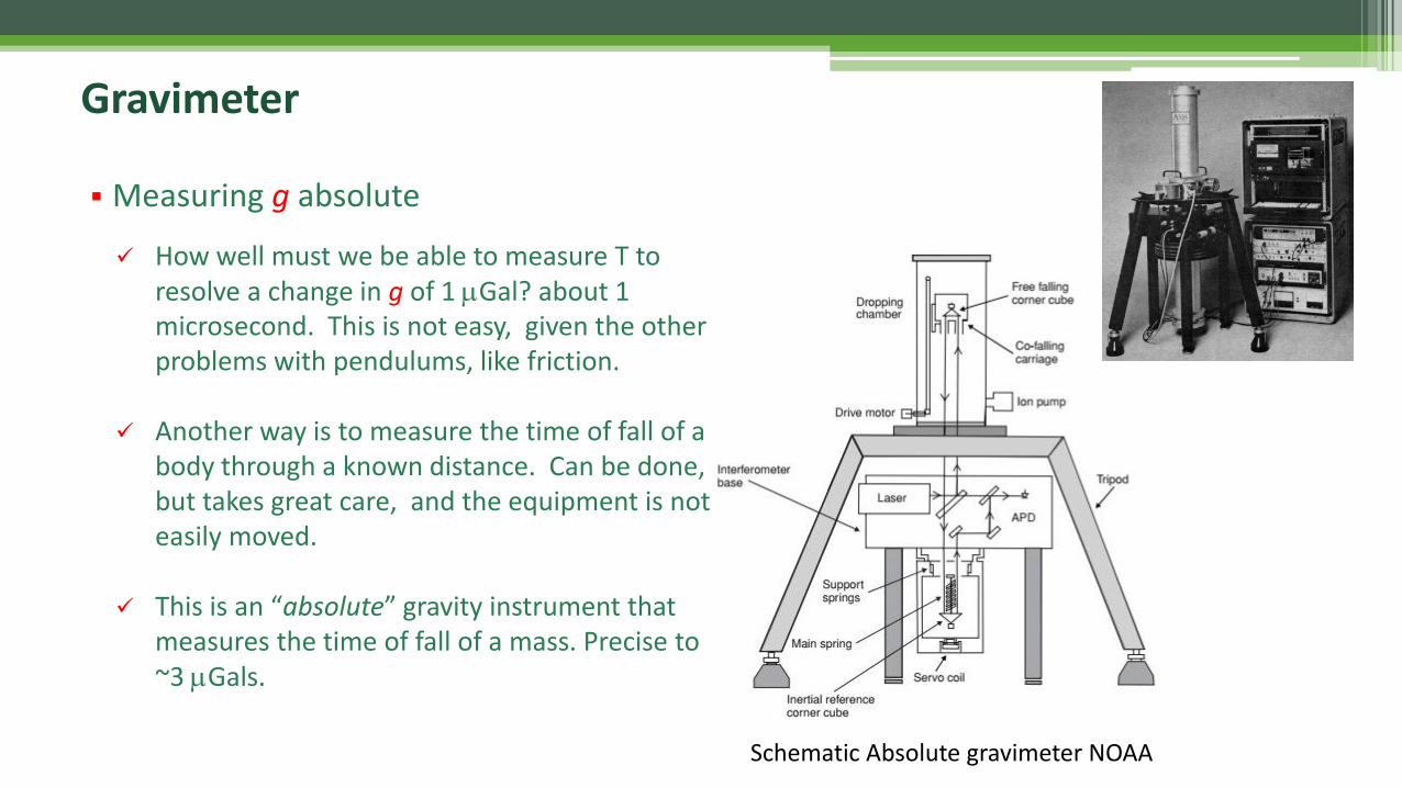
▪ Measuring g absolute
Gravimeter
Schematic Absolute gravimeter NOAA
✓ How well must we be able to measure T to resolve a change in g of 1 mGal? about 1 microsecond. This is not easy, given the other problems with pendulums, like friction.
✓ Another way is to measure the time of fall of a body through a known distance. Can be done, but takes great care, and the equipment is not easily moved.
✓ This is an “absolute” gravity instrument that measures the time of fall of a mass. Precise to ~3 mGals.
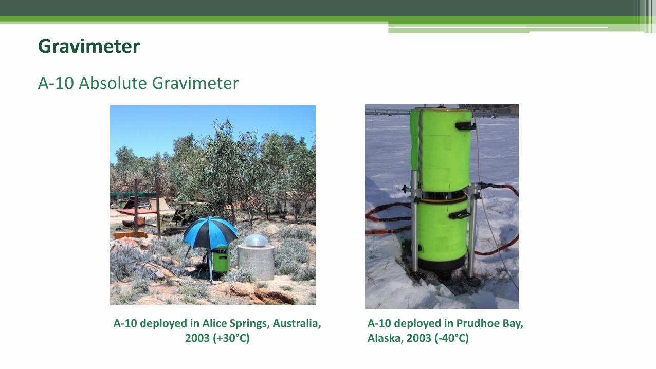
A-10 deployed in Alice Springs, Australia, 2003 (+30°C)
A-10 deployed in Prudhoe Bay, Alaska, 2003 (-40°C)
A-10 Absolute Gravimeter
Gravimeter
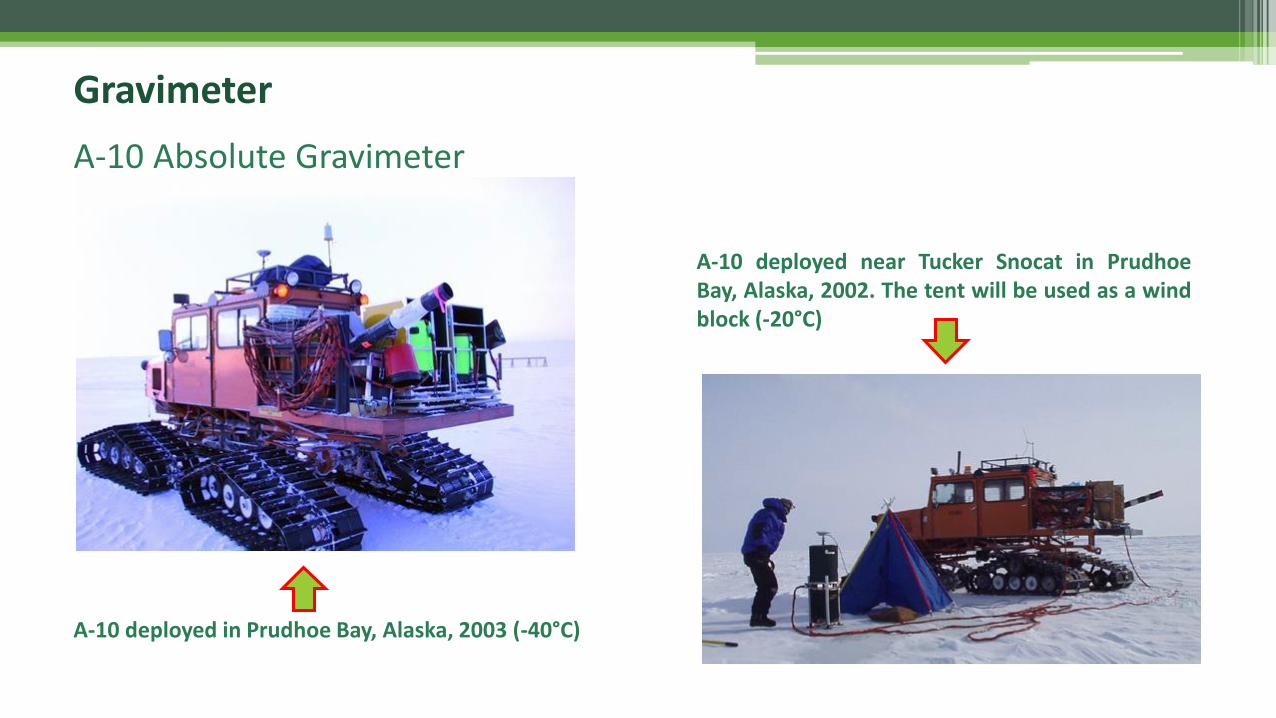
A-10 deployed near Tucker Snocat in PrudhoeBay, Alaska, 2002. The tent will be used as a windblock (-20°C)
A-10 deployed in Prudhoe Bay, Alaska, 2003 (-40°C)
A-10 Absolute Gravimeter
Gravimeter
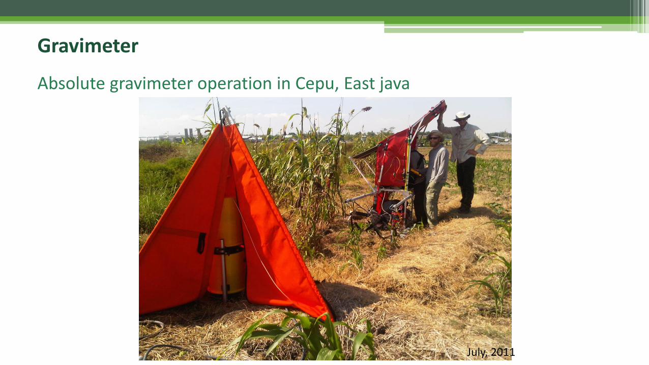
July, 2011
Absolute gravimeter operation in Cepu, East java
Gravimeter
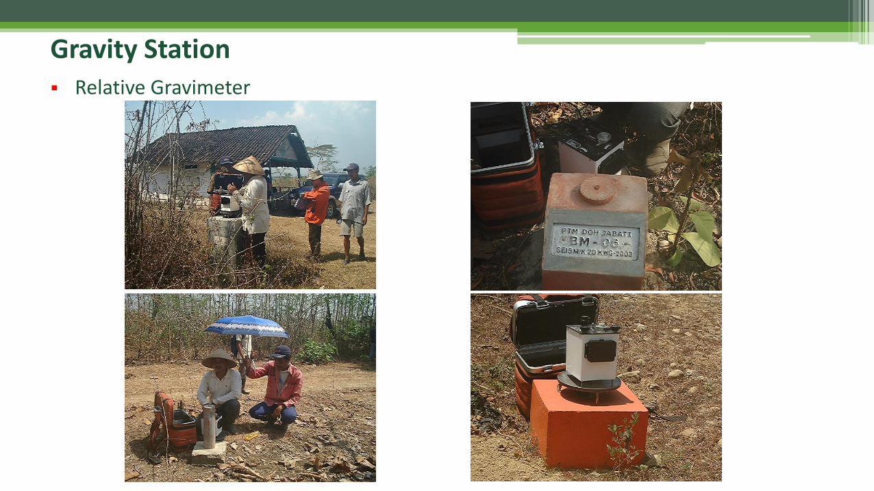
Gravity Station▪ Relative Gravimeter
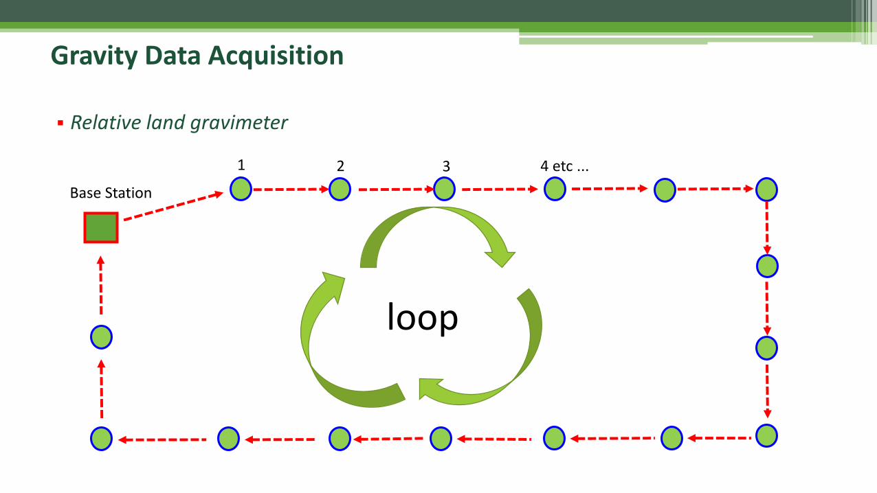
Base Station
1 2 3 4 etc ...
loop
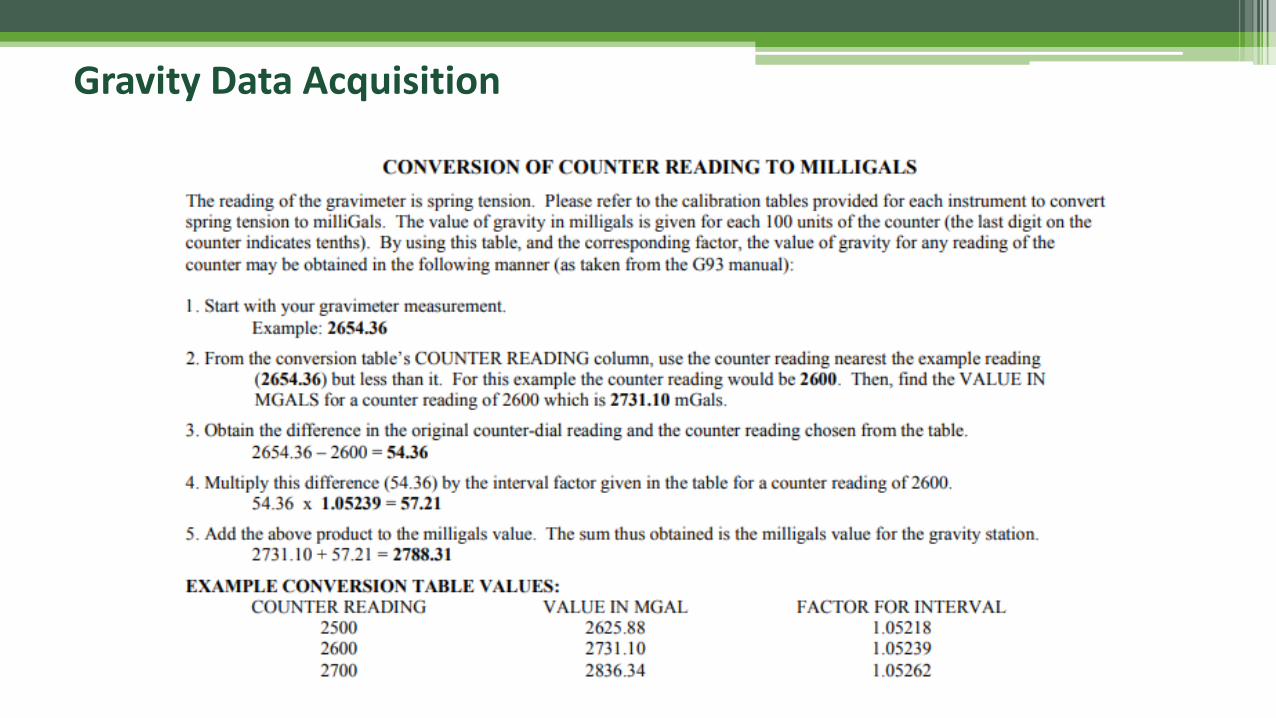
Gravity Data Acquisition
▪ Relative land gravimeter
Gravity Data Acquisition
Thank you,See you for the next lecture ....